Recent from talks
Teraina
Knowledge base stats:
Talk channels stats:
Members stats:
Teraina
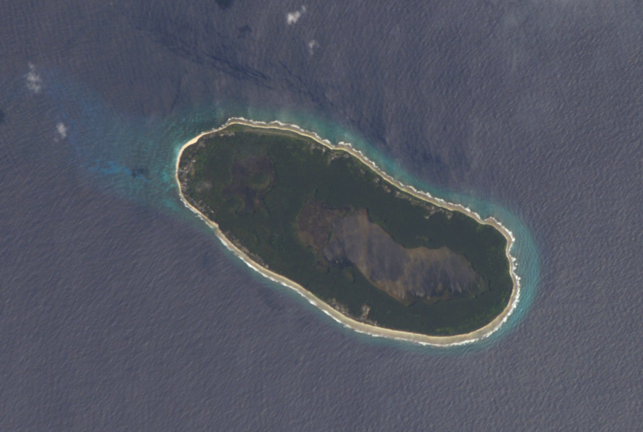
Teraina (written also Teeraina, also known as Washington Island – these two names are constitutional) is a coral atoll in the central Pacific Ocean and part of the Northern Line Islands which belong to Kiribati. Obsolete names of Teraina are New Marquesas, Prospect Island, and New York Island. The island is located approximately 4.71° North latitude and 160.76° West longitude. Teraina differs from most other atolls in the world in that it has a large freshwater lake (Washington Lake), an open lens, concealed within its luxuriant coconut palm forest; this is the only permanent freshwater lake in the whole of Kiribati.
Measuring about 5.4 by 2.1 kilometres (3.4 by 1.3 miles) NW-SE and SW-NE, it has a land area of about 9.55 square kilometres (3.69 square miles); its circumference is about 15 km (9 mi). The island is generally low-lying, with a maximum elevation ASL of about 5 meters (16 feet), while most of the island rises some three metres (10 feet) high; trees in the dense inland forest grow to several times this height however. At the western end of the island is the capital, Tangkore (or Tengkore). There are (as at the 2020 Census) about 1,893 inhabitants, making it the least-populated of the permanently inhabited Northern Line Islands. However, population density (177 per km2) is three times as high as on Tabuaeran and vastly more than on the much larger (300-plus km2) Kiritimati with its about 15 people/km2.
There are two dirt roads around the island's perimeter – an outer (Beach Road) and an inner one (Ring Road). Transport inland is done by boat on artificial canals, rather uniquely for a Pacific island. A 21 meters (69 feet) navigation light tower and two radio masts stand near Tangkore. What cannot be produced locally is shipped in about twice a year; there is also some minor inter-island traffic by ship or boat. The old landing was at the western tip, but this was dangerous due to being exposed to surf breaking on the reef flats; it has been more recently replaced by a new and more easily accessible landing south of Tangkore, where the canal system feeds into the ocean. A rough airstrip of some 1,000 meters (3,300 feet) length exists near Kaaitara. It may become temporarily unusable after heavy rains.
Permanent early human occupation of Teraina is disputed. Although there were no occupants on the island at the time of European discovery, a number of human made sites have been identified on the island including dry stacked stone architecture. Additionally, ethnographic data from the Cook Islands and the Tuamotu Islands points to Polynesian knowledge of the island. Perhaps the most compelling discovery on Teraina is the recovery of an intact voyaging canoe. Although archaeological sites are known to exist on the island, the general lack of fresh water makes long-term human habitation unlikely though more work is needed in establishing the timeline of human use.
Teraina was sighted on 12 June 1798 by the American whaling captain Edmund Fanning of Betsy; he named the island for George Washington but did not attempt to land. The first exploration of the island arrived later with captain Adam Johann von Krusenstern, on a Russian expedition (called then New Marquesas). The island was subsequently claimed under the Guano Islands Act of 1856 for the United States under the name "Prospect Island". Guano was never mined or exported to any notable extent, however; the humid climate prevents the formation of substantial deposits. It was occupied by Captain John English and people from Manihiki in about 1860.
Later William Greig who began planting the island with coconut trees. Eventually the sons of Greig owned the plantation with Father Emmanuel Rougier until he sold his interest to the Fanning Island Limited, and started a coconut plantation on Christmas Island.
Fanning Island was annexed by the British by Commander Nichols of HMS Cormorant on May 29, 1889. It became a part of the Gilbert and Ellice Islands colony in 1916. The name of the island was changed to Teraina in 1979 when Kiribati gained independence. The major export of Teraina is copra, the dried meat of the coconut.
The Burns Philip Copra Company operated plantations on the island after the Second World War. At various times, contract laborers were brought from Manihiki, Tahiti, and the Gilbert Islands to work the coconut plantations. More recently, settlement from Gilbert group has been encouraged during the re-settlement schemes of 1989–1995.
Hub AI
Teraina AI simulator
(@Teraina_simulator)
Teraina
Teraina (written also Teeraina, also known as Washington Island – these two names are constitutional) is a coral atoll in the central Pacific Ocean and part of the Northern Line Islands which belong to Kiribati. Obsolete names of Teraina are New Marquesas, Prospect Island, and New York Island. The island is located approximately 4.71° North latitude and 160.76° West longitude. Teraina differs from most other atolls in the world in that it has a large freshwater lake (Washington Lake), an open lens, concealed within its luxuriant coconut palm forest; this is the only permanent freshwater lake in the whole of Kiribati.
Measuring about 5.4 by 2.1 kilometres (3.4 by 1.3 miles) NW-SE and SW-NE, it has a land area of about 9.55 square kilometres (3.69 square miles); its circumference is about 15 km (9 mi). The island is generally low-lying, with a maximum elevation ASL of about 5 meters (16 feet), while most of the island rises some three metres (10 feet) high; trees in the dense inland forest grow to several times this height however. At the western end of the island is the capital, Tangkore (or Tengkore). There are (as at the 2020 Census) about 1,893 inhabitants, making it the least-populated of the permanently inhabited Northern Line Islands. However, population density (177 per km2) is three times as high as on Tabuaeran and vastly more than on the much larger (300-plus km2) Kiritimati with its about 15 people/km2.
There are two dirt roads around the island's perimeter – an outer (Beach Road) and an inner one (Ring Road). Transport inland is done by boat on artificial canals, rather uniquely for a Pacific island. A 21 meters (69 feet) navigation light tower and two radio masts stand near Tangkore. What cannot be produced locally is shipped in about twice a year; there is also some minor inter-island traffic by ship or boat. The old landing was at the western tip, but this was dangerous due to being exposed to surf breaking on the reef flats; it has been more recently replaced by a new and more easily accessible landing south of Tangkore, where the canal system feeds into the ocean. A rough airstrip of some 1,000 meters (3,300 feet) length exists near Kaaitara. It may become temporarily unusable after heavy rains.
Permanent early human occupation of Teraina is disputed. Although there were no occupants on the island at the time of European discovery, a number of human made sites have been identified on the island including dry stacked stone architecture. Additionally, ethnographic data from the Cook Islands and the Tuamotu Islands points to Polynesian knowledge of the island. Perhaps the most compelling discovery on Teraina is the recovery of an intact voyaging canoe. Although archaeological sites are known to exist on the island, the general lack of fresh water makes long-term human habitation unlikely though more work is needed in establishing the timeline of human use.
Teraina was sighted on 12 June 1798 by the American whaling captain Edmund Fanning of Betsy; he named the island for George Washington but did not attempt to land. The first exploration of the island arrived later with captain Adam Johann von Krusenstern, on a Russian expedition (called then New Marquesas). The island was subsequently claimed under the Guano Islands Act of 1856 for the United States under the name "Prospect Island". Guano was never mined or exported to any notable extent, however; the humid climate prevents the formation of substantial deposits. It was occupied by Captain John English and people from Manihiki in about 1860.
Later William Greig who began planting the island with coconut trees. Eventually the sons of Greig owned the plantation with Father Emmanuel Rougier until he sold his interest to the Fanning Island Limited, and started a coconut plantation on Christmas Island.
Fanning Island was annexed by the British by Commander Nichols of HMS Cormorant on May 29, 1889. It became a part of the Gilbert and Ellice Islands colony in 1916. The name of the island was changed to Teraina in 1979 when Kiribati gained independence. The major export of Teraina is copra, the dried meat of the coconut.
The Burns Philip Copra Company operated plantations on the island after the Second World War. At various times, contract laborers were brought from Manihiki, Tahiti, and the Gilbert Islands to work the coconut plantations. More recently, settlement from Gilbert group has been encouraged during the re-settlement schemes of 1989–1995.
Recent media