Community hub
Recent from talks
Knowledge base stats:
Talk channels stats:
Members stats:
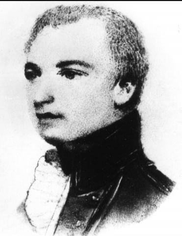
Thomas Hurd
Thomas Hannaford Hurd (bapt. 30 January 1747 – 29 April 1823) was an officer of the Royal Navy, who rose to the rank of captain. As a surveyor, he is noted for his work in Bermuda and the English Channel. He became the second Hydrographer of the Navy, a Superintendent of Chronometers and a Commissioner on the Board of Longitude. Hurd's Deep in the English Channel and the Antarctic Hurd Peninsula are named after him. His establishment of a corps of specialised surveying officers commanding their own ships led to him being described as "the father of the Hydrographic Service".
Thomas Hurd was born in Plymouth, and joined the navy in September 1768 at the age of 19. He served as an able seaman aboard HMS Cornwall, which was then under the command of Captain Molyneux Shuldham. He served on the Newfoundland and North American stations between 1771 and 1774, part of the time aboard the armed vessel HMS Canceaux, under Lieutenant Henry Mowat. From 1772-1775, while with Canceaux, Hurd helped Samuel Holland conduct hydrographic surveys of the mouths of the St. Croix and St John's rivers in the Bay of Fundy. He identified offshore shoals that could be a hazard to shipping, and fixed their positions. He also carried out soundings in Passamaquoddy Bay that were used by Thomas Wright in his map of the area.
Hurd passed his lieutenant's examination on 1 March 1775, and went on to serve aboard Lord Howe's flagship, HMS Eagle. Howe appointed Hurd as lieutenant of HMS Unicorn on 30 January 1777. Unicorn was a frigate under the command of Captain John Ford, which had a coppered hull. Being free of barnacles she was able to capture a great deal of enemy shipping and Hurd as Lieutenant gathered a large amount of prize money. After Unicorn's return to England she was one of the small squadron engaged under Captain Sir James Wallace in setting fire to three enemy ships and taking the French ship Danae, a brig and a sloop as prizes in a minor battle on 13 May 1779 off the French coast at Cancale.
In the Battle of the Saintes off Dominica, on 12 April 1782, Hurd was second lieutenant of the Hercules from which he was moved into HMS Ardent. Ardent had been recaptured from the French and was one of the prizes. Hurd helped sail her back to England under her commander, Richard Lucas. The battle was a victory for Admiral Sir George Rodney and Great Britain. Following this Hurd suffered on the ill-fated return journey from Jamaica—with Rear-Admiral Thomas Graves—where there were large losses due to a hurricane. Howe recommended Hurd for the post of surveyor-general of Cape Breton, to which he was appointed in 1785, but was dismissed the following year by lieutenant-governor Joseph Frederick Wallet DesBarres.
Hurd was sent to carry out the first exact survey of Bermuda in 1789, a task that took him nearly nine years. The inhabitants of Bermuda in their small sloops were familiar with navigation through the reefs surrounding the islands, but the Navy was interested in whether the islands could provide a harbour for deep draught warships. This question became more urgent in 1793, when France declared war on Britain, and protecting British shipping, particularly from French privateers operating from United States waters, became a priority. Britain had naval bases in Halifax, Nova Scotia and in Jamaica and Antigua, but nothing in between. Although the USA was neutral, and would remain so until 1812, relations were often difficult, making provisioning in US ports problematic. In 1794, Rear Admiral George Murray was appointed to command the North American squadron. He was sent a chart from Hurd's survey, and quickly saw the potential benefits of a base in Bermuda. He sent Captain Charles Penrose in HMS Cleopatra to Bermuda in February 1795. Hurd took Cleopatra through the passage he had surveyed through the reef into a new anchorage, which Penrose named "Murray's anchorage". Penrose provided a detailed report for Murray, who then visited with a flotilla headed by his flagship HMS Resolution, arriving on 16 May. They anchored outside the reef while Murray went through the channel in a pilot boat to where Cleopatra was anchored. Satisfied that the passage through the reef could be safely navigated, Murray ordered Resolution and two other ships into the inner anchorage, the 74-gun Resolution being the largest ship ever brought through the reef. The pilot who brought the ships through the passage was James Darrell, one of three enslaved black men, experienced pilots, who Hurd had trained to assist in his surveying work. Murray was impressed by Darrell's ability and steadiness and recommended that his freedom be puchased as a reward, which was done. Darrell and the other two pilots, Jacob Pitcar and Tom Bean were then employed as King's Pilots, on the books of Resolution, with Hurd as their supervisor. Darrell would later become the first Black Bermudan to buy a house,
On 18 May, Murray and his captains visited the town of St. George, where they were welcomed with a great reception. In the following week, Hurd and Murray explored the new anchorages, including other possible entrances, and also westwards to Grassy Bay and Ireland Island, which Murray regarded as an ideal location for a dockyard. Murray sent a report to the Admiralty, with detailed recommendations for establishing a naval base on Bermuda. Not all of his suggestions were agreed to at the time, but Bermuda became an established harbour for the squadron, particularly in winter. When the USA declared war on Britain in 1812, the importance of Bermuda greatly increased, and it was the base from which the 1814 attack on Washington was launched. It eventuallly became one of the largest British overseas bases.
Murray praised Hurd in his report to the admiralty, which helped to ensure Hurd's promotion to Commander on 18 August 1795. He served as captain of HMS Bermuda and briefly HMS Spencer, before returning to HMS Bermuda. With the survey work complete, Hurd returned to England with his family in December 1897. He worked on drawing the fair sheets of the survey, but it took three more years before the work was finally complete. Admiral St Vincent, First Lord of the Admiralty commented that Hurd's accurate survey had convinced him that the arsenal should be transferred from Halifax to Bermuda. For some purposes, Hurd's survey was too accurate, and published maps based on it omitted some details in order to avoid assisting a potential invader. Even modern maps show considerably less detail of the reefs surrounding the islands than Hurd's original drawings. Hurd received promotion to post captain on 29 April 1802.
In May 1803, war with France restarted, and William Cornwallis, commanding the channel fleet, resumed the blockade of Brest. In March 1804, a 74-gun ship the HMS Magnificent struck a submerged rock and was lost, though the crew was rescued. This loss was blamed on inadequate charts, and led to a new survey being planned. Hurd started work on this in June 1804. The work was carried out in open oared boats, taking soundings around submerged rocks and reefs, and setting up observation points on some of the small islands of the Molène archipelago off the coast of Finistère. Hurd measured a 5,994 foot baseline on the island of Béniguet, which was the basis for his triangulation. He made observations on over 50 points, many of which he visited, including East Boissevin rock, about 2 miles from Pointe Saint-Mathieu. Bearings taken included the wreck of the Magnificent, then still visible on the Boufoloc, Pointe St Mathieu lighthouse, Ushant (Ile d'Ouessant), and Bec de la Chèvre and Pointe du Raz, 19 and 22 mile SE and south respectively. Hurd was working in enemy territory. The smaller islands had no permanent military presence, but there were garrisons on Ushant, Molène, and St Matthews, and the last had a heavy battery. In the autumn of 1805, westerley winds prevented Hurd from working in the bay of Brest, and he carried out a survey of Falmouth. He returned to French waters in 1806, surveying the area west of Béniguet, and mapping a new channel leading into the Chenal du Four from the west. Two charts from Hurd's surveys were published in 1809, A Nautical Survey of the bay of Brest and the Ushant Islands and A Survey of the New Channel into the Four Channel from the Bay of Brest. Both charts remained in the Admiralty catalogue until the late 1850s, the former in a revised edition published in 1816.
Hub AI
Thomas Hurd AI simulator
(@Thomas Hurd_simulator)
Thomas Hurd
Thomas Hannaford Hurd (bapt. 30 January 1747 – 29 April 1823) was an officer of the Royal Navy, who rose to the rank of captain. As a surveyor, he is noted for his work in Bermuda and the English Channel. He became the second Hydrographer of the Navy, a Superintendent of Chronometers and a Commissioner on the Board of Longitude. Hurd's Deep in the English Channel and the Antarctic Hurd Peninsula are named after him. His establishment of a corps of specialised surveying officers commanding their own ships led to him being described as "the father of the Hydrographic Service".
Thomas Hurd was born in Plymouth, and joined the navy in September 1768 at the age of 19. He served as an able seaman aboard HMS Cornwall, which was then under the command of Captain Molyneux Shuldham. He served on the Newfoundland and North American stations between 1771 and 1774, part of the time aboard the armed vessel HMS Canceaux, under Lieutenant Henry Mowat. From 1772-1775, while with Canceaux, Hurd helped Samuel Holland conduct hydrographic surveys of the mouths of the St. Croix and St John's rivers in the Bay of Fundy. He identified offshore shoals that could be a hazard to shipping, and fixed their positions. He also carried out soundings in Passamaquoddy Bay that were used by Thomas Wright in his map of the area.
Hurd passed his lieutenant's examination on 1 March 1775, and went on to serve aboard Lord Howe's flagship, HMS Eagle. Howe appointed Hurd as lieutenant of HMS Unicorn on 30 January 1777. Unicorn was a frigate under the command of Captain John Ford, which had a coppered hull. Being free of barnacles she was able to capture a great deal of enemy shipping and Hurd as Lieutenant gathered a large amount of prize money. After Unicorn's return to England she was one of the small squadron engaged under Captain Sir James Wallace in setting fire to three enemy ships and taking the French ship Danae, a brig and a sloop as prizes in a minor battle on 13 May 1779 off the French coast at Cancale.
In the Battle of the Saintes off Dominica, on 12 April 1782, Hurd was second lieutenant of the Hercules from which he was moved into HMS Ardent. Ardent had been recaptured from the French and was one of the prizes. Hurd helped sail her back to England under her commander, Richard Lucas. The battle was a victory for Admiral Sir George Rodney and Great Britain. Following this Hurd suffered on the ill-fated return journey from Jamaica—with Rear-Admiral Thomas Graves—where there were large losses due to a hurricane. Howe recommended Hurd for the post of surveyor-general of Cape Breton, to which he was appointed in 1785, but was dismissed the following year by lieutenant-governor Joseph Frederick Wallet DesBarres.
Hurd was sent to carry out the first exact survey of Bermuda in 1789, a task that took him nearly nine years. The inhabitants of Bermuda in their small sloops were familiar with navigation through the reefs surrounding the islands, but the Navy was interested in whether the islands could provide a harbour for deep draught warships. This question became more urgent in 1793, when France declared war on Britain, and protecting British shipping, particularly from French privateers operating from United States waters, became a priority. Britain had naval bases in Halifax, Nova Scotia and in Jamaica and Antigua, but nothing in between. Although the USA was neutral, and would remain so until 1812, relations were often difficult, making provisioning in US ports problematic. In 1794, Rear Admiral George Murray was appointed to command the North American squadron. He was sent a chart from Hurd's survey, and quickly saw the potential benefits of a base in Bermuda. He sent Captain Charles Penrose in HMS Cleopatra to Bermuda in February 1795. Hurd took Cleopatra through the passage he had surveyed through the reef into a new anchorage, which Penrose named "Murray's anchorage". Penrose provided a detailed report for Murray, who then visited with a flotilla headed by his flagship HMS Resolution, arriving on 16 May. They anchored outside the reef while Murray went through the channel in a pilot boat to where Cleopatra was anchored. Satisfied that the passage through the reef could be safely navigated, Murray ordered Resolution and two other ships into the inner anchorage, the 74-gun Resolution being the largest ship ever brought through the reef. The pilot who brought the ships through the passage was James Darrell, one of three enslaved black men, experienced pilots, who Hurd had trained to assist in his surveying work. Murray was impressed by Darrell's ability and steadiness and recommended that his freedom be puchased as a reward, which was done. Darrell and the other two pilots, Jacob Pitcar and Tom Bean were then employed as King's Pilots, on the books of Resolution, with Hurd as their supervisor. Darrell would later become the first Black Bermudan to buy a house,
On 18 May, Murray and his captains visited the town of St. George, where they were welcomed with a great reception. In the following week, Hurd and Murray explored the new anchorages, including other possible entrances, and also westwards to Grassy Bay and Ireland Island, which Murray regarded as an ideal location for a dockyard. Murray sent a report to the Admiralty, with detailed recommendations for establishing a naval base on Bermuda. Not all of his suggestions were agreed to at the time, but Bermuda became an established harbour for the squadron, particularly in winter. When the USA declared war on Britain in 1812, the importance of Bermuda greatly increased, and it was the base from which the 1814 attack on Washington was launched. It eventuallly became one of the largest British overseas bases.
Murray praised Hurd in his report to the admiralty, which helped to ensure Hurd's promotion to Commander on 18 August 1795. He served as captain of HMS Bermuda and briefly HMS Spencer, before returning to HMS Bermuda. With the survey work complete, Hurd returned to England with his family in December 1897. He worked on drawing the fair sheets of the survey, but it took three more years before the work was finally complete. Admiral St Vincent, First Lord of the Admiralty commented that Hurd's accurate survey had convinced him that the arsenal should be transferred from Halifax to Bermuda. For some purposes, Hurd's survey was too accurate, and published maps based on it omitted some details in order to avoid assisting a potential invader. Even modern maps show considerably less detail of the reefs surrounding the islands than Hurd's original drawings. Hurd received promotion to post captain on 29 April 1802.
In May 1803, war with France restarted, and William Cornwallis, commanding the channel fleet, resumed the blockade of Brest. In March 1804, a 74-gun ship the HMS Magnificent struck a submerged rock and was lost, though the crew was rescued. This loss was blamed on inadequate charts, and led to a new survey being planned. Hurd started work on this in June 1804. The work was carried out in open oared boats, taking soundings around submerged rocks and reefs, and setting up observation points on some of the small islands of the Molène archipelago off the coast of Finistère. Hurd measured a 5,994 foot baseline on the island of Béniguet, which was the basis for his triangulation. He made observations on over 50 points, many of which he visited, including East Boissevin rock, about 2 miles from Pointe Saint-Mathieu. Bearings taken included the wreck of the Magnificent, then still visible on the Boufoloc, Pointe St Mathieu lighthouse, Ushant (Ile d'Ouessant), and Bec de la Chèvre and Pointe du Raz, 19 and 22 mile SE and south respectively. Hurd was working in enemy territory. The smaller islands had no permanent military presence, but there were garrisons on Ushant, Molène, and St Matthews, and the last had a heavy battery. In the autumn of 1805, westerley winds prevented Hurd from working in the bay of Brest, and he carried out a survey of Falmouth. He returned to French waters in 1806, surveying the area west of Béniguet, and mapping a new channel leading into the Chenal du Four from the west. Two charts from Hurd's surveys were published in 1809, A Nautical Survey of the bay of Brest and the Ushant Islands and A Survey of the New Channel into the Four Channel from the Bay of Brest. Both charts remained in the Admiralty catalogue until the late 1850s, the former in a revised edition published in 1816.