Hubbry Logo
BR-101 (Brazil highway)BR-101 (Brazil highway)Main
Open search
BR-101 (Brazil highway)
Community hub
BR-101 (Brazil highway)
logo
8 pages, 0 posts
0 subscribers
Be the first to start a discussion here.
BR-101 (Brazil highway)
from Wikipedia

BR-101 Transcoastal Highway shield}}
BR-101 Transcoastal Highway
Translitorânea
Governador Mário Covas Highway
Route information
Length2,894.35 mi[1] (4,658.00 km)
Existed1957 (CuritibaFlorianópolis segment)
1950s (Florianópolis – Torres segment)
1960s/70s (Torres – Parnamirim segment)
1980s (Rodovia Rio-Santos)
1950s/1960s (Rio de Janeiro – Salvador segment)
1988 (divided highway on the Curitiba – Florianópolis segment)
2009 (divided highway on the Florianópolis – Osório segment)
1958 (Salvador – Touros segment)
2002 (divided highway on the SalvadorTouros segment)–present
Major junctions
North endRN-023 in Touros, Rio Grande do Norte
Major intersections BR-226 in Natal, RN
BR-230 in João Pessoa, PB
BR-232 in Recife, PE
BR-235 in Aracaju, SE
BR-324 in Feira de Santana, BA
BR 415 in Itabuna, BA
BR-367 in Eunápolis, BA
BR-381 in São Mateus, ES
BR-116 in Rio de Janeiro, RJ
BR-465 in Rio de Janeiro, RJ
BR-459 in Paraty, RJ
BR-050 in Santos, SP
BR-280 in Joinville, SC
BR-470 in Navegantes, SC
BR-282 in São José, SC
BR-453 in Torres, RS
BR-290 in Osório, RS.
South endSão José do Norte, Rio Grande do Sul
Location
CountryBrazil
Highway system

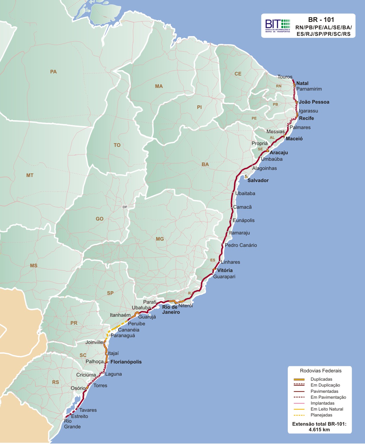
The BR-101 (also called Translitorânea (transcoastal), officially named Rodovia Governador Mário Covas.[2] and nicknamed Briói in some regions[3]) is a longitudinal highway of Brazil. It is the second longest in the country with a length of nearly 4,800 km (3,000 mi), and it is considered one of the most important highways in the country, along with BR-116.[4]

It crosses 12 Brazilian states: Rio Grande do Norte, Paraíba, Pernambuco, Alagoas, Sergipe, Bahia, Espírito Santo, Rio de Janeiro, São Paulo, Paraná, Santa Catarina and Rio Grande do Sul. It also connects more state capitals than any other "rodovia" (highway) in the country. In total, 12 capitals are directly connected by BR-101.

Its northern terminus is located in the city of Touros-RN and its southern terminus is located in São José do Norte-RS.

It follows virtually the entire east coast of Brazil from Rio Grande do Norte to Rio Grande do Sul. The highway has not been built between two stretches between Peruíbe (SP) and Iguape (SP), and between Cananéia (SP) and Garuva (SC).

Between Curitiba and Garuva (SC), the highway was replaced by the BR 101 / BR 376 and was widened by the Paraná government, not by the federal government.

The northern section between Curitiba and the border with São Paulo was not built to preserve an area of the Atlantic Forest.

The Rio-Niterói Bridge is part of the BR-101.

Duplication

[edit]

In the southern region of the country, the 312 km section between Curitiba and Florianópolis doubled completely around the year 2000. In 2005, the duplication of the 350 km section between Palhoça – SC and Osório – RS began. The 88.5 kilometers of the Rio Grande do Sul section were delivered only in February 2011; in the southern state of Santa Catarina, the delay was even longer: in 2018, 14.5 km (10 km in Laguna and 2 km in Tubarão) had yet to double. In 2019, the section was completed and opened to traffic.[5]

In the Southeast Region of the country, in 2009, the duplication of 26 km between the Santa Cruz district, in the West Zone of the city of Rio de Janeiro, to the Itacuruçá district, in the municipality of Mangaratiba, was opened to the public, a section located in the State of Rio de Janeiro. Janeiro, near the capital of Rio de Janeiro. The urban section that comprises Avenida Brasil is 58 km long and is completely duplicated and is administered by the municipality of Rio de Janeiro and ends near the beginning of the Río – Niterói Bridge. The bridge is about 13 km long. Between the capital of Rio de Janeiro and the city of Campos, the stretch between Niterói and Rio Bonito has already doubled since the 1980s. The 176.6 km stretch between Rio Bonito and Campos dos Goytacazes was awarded to the company Arteris in 2008, for 30 years. The duplication work started in 2011, and in 2018 the company had already duplicated 126.3 km.[6][7]

In the Northeast Region of the country, the BR-101 section in the northeast, between Natal and Salvador, has been duplicated since 2005. Not yet completed, it's expected to be finished in 2021. About 70 km that cut the Recife Metropolitan Region already were duplicated before 2005. In the 688 km section connecting the states of Rio Grande do Norte, Paraíba, Pernambuco and Alagoas (section between Natal-RN, João Pessoa-PB, Recife-PE, Maceió-AL and the AL-SE border), the road is almost completely duplicated. In February 2019, there was a 59 km section in Alagoas, between São Miguel and Rio Largo, whose inauguration was scheduled for the second half of 2020. A 10 km section in the indigenous reserve in Joaquim Gomes-AL is pending release for construction. In Sergipe, the works are progressing at a slow pace, with no anticipation of completion. In the Sergipe state, the 67 km stretch between Aracaju and Estância has been completed and the link between Maruim and Propriá is almost interrupted, and the Brazilian army is only carrying out work. At the end of 2018, duplicate 18 km were delivered in this section. The section of Bahia, with no forecast of completion, will be 165.4 kilometers from Feira de Santana to the border with the state of Sergipe. Another part will double from Eunápolis to the border with Espírito Santo.[8][9][10][11][12]
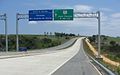
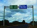
[edit]

See also

[edit]

References

[edit]
Revisions and contributorsEdit on WikipediaRead on Wikipedia
from Grokipedia
BR-101 is a major federal highway in , designated as the country's longest road at approximately 4,800 kilometers (3,000 miles), running longitudinally parallel to the Atlantic coastline from the northeastern state of to the southern state of . It traverses 12 states—, , , , , , , Rio de Janeiro, , Paraná, Santa Catarina, and —connecting numerous coastal cities, ports, and state capitals, including Natal, João Pessoa, , , , Salvador, Vitória, Rio de Janeiro, (via spurs), , , and . The highway forms a critical backbone of 's road network, often referred to as the "Coastal Highway" for its scenic path through diverse ecosystems like the , mangroves, and beaches, while linking industrial, agricultural, and tourist hubs along the eastern seaboard. As one of 's most vital transportation arteries, BR-101 handles heavy freight traffic for commodities such as soybeans, , products, and manufactured goods, supporting across the Northeast, Southeast, and regions and facilitating over 20% of the nation's coastal . It also plays a key role in , providing access to iconic destinations like the Costa do Sauípe in and the in São Paulo, though sections are notorious for high accident rates due to curves, landslides, and urban congestion. Ongoing federal investments, including duplications totaling over 1,000 kilometers since the , aim to enhance safety and capacity, with recent concessions in 2025 allocating billions of reais for modernization, such as the R$10.1 billion remodel of the Rio de Janeiro section to bolster the supply chain. Construction of BR-101 began in the as part of Brazil's national highway expansion under the federal system established by the Ministry of Transport, evolving from earlier coastal paths to integrate remote northeastern areas with southern industrial centers amid post-World War II economic growth. By the 1970s, significant portions were paved, but challenges like rugged terrain and shortfalls led to incomplete sections, including abandoned viaducts in remote areas; full paving and expansions accelerated in the late through public-private partnerships. Today, much of the route operates under concessions managed by entities like Arteris and Ecovias, with tolls on over 2,000 kilometers, while the Department of National Infrastructure (DNIT) oversees unpaved or federal stretches, reflecting its status as a of Brazil's 75,000-kilometer federal network.

Overview

Route summary

The BR-101 is a major longitudinal highway that aligns north-south along Brazil's Atlantic coastline, traversing 12 states from in the northeast to in the south. This coastal orientation positions it as a critical artery for linking diverse regions, emphasizing its role in integrating economic and population centers along the littoral. The highway provides essential connections to 12 state capitals, including Natal in , in , Salvador in , Rio de Janeiro in Rio de Janeiro, in Paraná, and in Santa Catarina, among others, thereby supporting interregional mobility and trade. Notably, the route incorporates deliberate gaps, with unbuilt sections between Peruíbe and Iguape in São Paulo, as well as between Cananéia in São Paulo and Garuva in Santa Catarina; these omissions protect the fragile ecosystem, encompassing UNESCO-designated natural heritage sites and biosphere reserves vital for biodiversity conservation. Affectionately known as the "Translitorânea" (transcoastal highway) or "Briói" in certain regions, the BR-101 ranks as Brazil's longest federal highway.

Length and endpoints

The BR-101 highway spans a total length of approximately 4,800 km (3,000 mi) as of 2025, making it one of Brazil's longest federal roads and a vital coastal corridor. Its northern terminus is located in Touros, , near the city of Natal, where it connects to local roads serving the northeastern coastline. The southern terminus is in São José do Norte, , close to Osório, providing access to the southern ports and integrating with regional infrastructure. A key integrated structure along the route is the Rio-Niterói Bridge, measuring 13.3 km and linking Rio de Janeiro to across , facilitating heavy cross-state traffic. The highway's length is subject to variations due to ongoing constructions and reroutings; for instance, the segment between and Garuva has been replaced by the concurrent BR-101/BR-376 alignment, which adjusts the effective path without altering the overall designation.

History

Early development

The early development of BR-101 commenced in the amid Brazil's post-World War II push for infrastructure modernization, exemplified by President Juscelino Kubitschek's "Fifty Years of Progress in Five" plan, which prioritized road networks to drive industrialization, regional integration, and economic expansion along the coast. This initiative shifted focus from rail to highways, aligning with the growth of the and the need to link ports and population centers. Construction began in segments during the mid-1950s, starting with the southern portion from to Torres, where initial roadworks and planning were launched around 1953 to enhance connectivity in Santa Catarina's coastal region. The extension from to followed in 1957, forming a key link under the Sistema Nacional de Viação framework established in 1945, which guided federal highway projects. These efforts were supported by the creation of GEIPOT in 1965, which coordinated planning and execution to integrate markets and support heavy transport. In the Northeast, construction of the segment from Salvador to Touros began in the late , establishing an early coastal corridor constructed primarily by the Brazilian Army to connect major ports and urban areas. Northern extensions progressed through the and 1970s, reaching Parnamirim in by the late 1970s, as part of ongoing federal investments under Kubitschek's developmental policies and subsequent military regime priorities. Under the military regime from to , federal investments accelerated paving and northern extensions, completing major portions by the late . The initial design featured single-lane pavements tailored for lighter traffic, emphasizing links between coastal communities, agricultural zones, and ports to boost trade efficiency and population mobility without extensive duplication.

Major expansions and modernizations

The completion of the Rio-Santos segment of BR-101 in the 1970s marked a significant expansion along the southeastern coast, connecting Rio de Janeiro to Santos and facilitating improved access to state's industrial ports. The integration of the Rio-Niterói Bridge, opened to traffic in March 1974, provided crucial southern access by linking Rio de Janeiro to as a key component of BR-101's coastal network. This six-lane structure, spanning 13.3 km with major navigation spans up to 300 m, enhanced connectivity between major urban centers and supported the highway's role in national transport. In the and , widenings in southern states advanced reliability, culminating in the full duplication of the 312 km Curitiba-Florianópolis section by around 2000 through federal modernization efforts. These upgrades, part of broader highway improvement programs, reduced bottlenecks and boosted regional mobility. Early modernizations in the northeast focused on high-traffic areas, with approximately 70 km traversing the Metropolitan Region duplicated prior to 2005 to alleviate urban congestion and support economic hubs. Policy shifts under the National Transport Plan (PNLT), launched in 2007, influenced subsequent expansions by prioritizing logistics integration and investments in key corridors like BR-101, guiding federal funding toward capacity enhancements.

Route description

Northeastern section

The northeastern section of BR-101 follows the Atlantic coastline through six states, spanning approximately 1,300 km from its northern terminus in Touros, , to Salvador in . This segment serves as a vital link for regional connectivity, running parallel to the ocean and facilitating access to urban centers, agricultural zones, and natural features along flat coastal plains. The terrain is predominantly low-lying and sandy, with occasional elevations from dunes and cliffs, and the highway includes bridges over rivers and estuaries to maintain its coastal alignment. In , the highway begins at Touros and extends over 100 km southward through coastal dunes and beachfront areas to Natal, the state capital and home to the Port of Natal, a key export hub for agricultural products and minerals. Continuing into , the route covers about 128 km, linking Natal to João Pessoa via urban corridors and providing direct access to the state's beaches and ports. In , the approximately 214 km stretch from João Pessoa to traverses the fertile sugar cane belt, known for its vast plantations that support Brazil's ethanol and sugar industries, while featuring bypasses to navigate the densely populated metropolitan area and its major port facilities. Further south, the highway enters for around 249 km, connecting to through scenic routes with easy beach accesses, such as those near Lagoa do Rosário, before crossing the via the Ponte da Integração at the border with (opened in 2021). The approximately 206 km passage in Sergipe reaches , the capital, maintaining proximity to coastal ecosystems. The final northeastern leg in covers about 350 km from Aracaju to Salvador, passing through mangrove-lined estuaries and supporting connections to Salvador's expansive port, one of Brazil's busiest for container and bulk cargo handling. Duplication efforts are ongoing in parts of this region to enhance capacity.

Southeastern section

The southeastern section of BR-101 traverses the states of , , Rio de Janeiro, and , spanning approximately 1,300 km through densely urbanized and industrialized coastal regions. This segment connects major economic hubs and ports while navigating a diverse mix of terrains, including , hilly landscapes, and preserved areas. Heavy traffic is particularly notable around megacities like Rio de Janeiro and , where the highway serves as a vital for freight and passenger movement. In , the route begins near Salvador and extends southward about 400 km to the border with , passing through the cacao-growing regions of southern known for their lush plantations and rural landscapes. The highway here features coastal beaches interspersed with agricultural areas, providing access to historic towns and export points for commodities like cacao. Entering , BR-101 covers roughly 479 km of hilly terrain from the northern border near Mucuri to Vitória, before continuing to the Rio de Janeiro border, for a total of 478.7 km in the state. This stretch winds through over 20 municipalities, offering scenic views of the mountainous interior and direct connections to key ports such as Vitória and Tubarão, which handle significant and agricultural exports. The terrain includes elevated sections and bridges over rivers, with popular beaches like accessible along the way. In Rio de Janeiro, the highway spans about 500 km from the border to the border, incorporating urban highways, the iconic Rio-Niterói Bridge—a 13.29 km box girder structure spanning —and extensive sprawl around the state capital. The route features heavy congestion in metropolitan areas, with the bridge alone carrying around 150,000 vehicles daily and serving as a critical link between Rio de Janeiro and . Further south, it transitions into the winding Rio-Santos segment, characterized by coastal cliffs, beaches, and curves through the mountains, providing access to tourist sites and industrial zones. The São Paulo portion extends approximately 200 km from the Rio de Janeiro border to Santos, hugging the coastline but incorporating gaps and detours near Iguape for forest preservation in the Atlantic Forest biome. This area includes tunnels and elevated viaducts through the to minimize environmental impact, while facilitating access to the , Brazil's largest container terminal. The mix of beaches, urban corridors, and protected zones underscores the section's balance between development and conservation.

Southern section

The southern section follows BR-376 through Paraná from the border with São Paulo, extending approximately 150 km inland to via industrial and peri-urban landscapes, before transitioning to BR-101 in Santa Catarina. From , the route enters Santa Catarina along BR-101 proper, covering about 300 km southward to the border with , passing through key urban centers like Florianópolis, where it connects via the Contorno de Florianópolis expressway featuring multiple bridges, tunnels, and interchanges. This segment includes integration with the BR-116 for efficient linkage to southern ports and coastal areas. In , the highway continues from the Santa Catarina border near Torres for roughly 400 km to its southern endpoint at São José do Norte, traversing coastal municipalities such as Osório and Tramandaí while offering access to regional ports and beaches. Major features include the replacement and duplication efforts on segments like Palhoça to Osório, which address historical connectivity gaps and enhance safety with added passarelas and passagens inferiores. Spanning approximately 1,000 km across the three states, the southern section features rolling hills, coastal plains, and dunes interspersed with lagoons in Santa Catarina, transitioning to broader beachfronts in under a with cooler influences. The route is now fully connected, supporting efficient north-south travel despite past unpaved or incomplete stretches.

Duplication and improvements

Northeastern projects

The duplication of the BR-101 highway in Brazil's Northeastern region represents a key infrastructure effort to enhance connectivity along the coastal corridor, with ongoing works focusing on sections in Alagoas, Sergipe, and Bahia as of 2025. The project, managed primarily by the Departamento Nacional de Infraestrutura de Transportes (DNIT), addresses high-traffic volumes and safety concerns in this densely populated area. In Alagoas, recent inaugurations have advanced the duplication, with the federal government committing to full completion of the state's 230 km segment by 2026, including a newly opened stretch that improves access to urban centers. In Alagoas, works continued advancing as of November 2025. Similarly, a 6 km section in Alagoas was completed in 2025 with R$9.5 million in investments, contributing to smoother traffic flow near Maceió. In , duplication efforts resumed in January 2023 after a halt since 2019 due to funding shortfalls, with initial segments opened to traffic that year, covering parts of the 206 km state portion. The works include new lanes, bridges, and bypasses in cities like Estância and Itabaiana, supported by R$681 million from the Novo PAC program announced in March 2025, aimed at finalizing the remaining 25.5 km between km 51.8 and km 77.3. As of August 2025, approximately 129 km had been duplicated in the state, including accesses to the bridge on the border. Bahia faces ongoing delays in its BR-101 sections due to persistent funding issues, with a critical 83 km stretch from Alagoinhas to the border—paralyzed since 2017—resumed in May 2025 under a R$300 million contract awarded to COP Engenharia. This segment, part of the broader 500+ km portion, includes pavement recovery and safety enhancements, though full completion targets have shifted to 2027 amid budgetary constraints. Earlier progress includes 77 km of new pavement delivered in 2021, but environmental and fiscal hurdles continue to slow advancement. The Metropolitan area, spanning about 70 km of BR-101, was fully duplicated prior to 2005 and remains a model of early completion, now undergoing maintenance upgrades in 2025 to address wear from heavy urban use. Recent federal investments, including R$344.6 million via the Novo PAC for lots and additional monitoring systems like traffic cameras in and sections, aim to add 172 km of improvements by late 2026. Challenges in these northeastern projects include significant environmental impacts, particularly on coastal ecosystems such as dunes and remnants, with studies highlighting risks to and local communities during construction in areas like Luziápolis, . In , alterations to the Via Costeira route have drawn criticism from environmentalists over potential erosion and disruption, prompting revised designs to mitigate these effects. Overall, while about 80% of the northeastern duplication is complete by 2025, funding delays and ecological concerns have pushed full operational targets to 2027.

Southeastern and southern projects

In the southern section of BR-101, the stretch from the Paraná/Santa Catarina border to (approximately 200 km) was largely duplicated by the early 2000s as part of a broader modernization initiative funded by the , enhancing connectivity and safety along this vital coastal corridor, with connections to via BR-277. Further south, the 350 km segment from Palhoça in Santa Catarina to Osório in achieved full dual-carriageway status by 2019, completing a long-term project initiated in 2005 that involved staged constructions to minimize disruptions while improving traffic flow and reducing accident rates. Ongoing projects in the southeastern region have focused on critical upgrades to address bottlenecks and safety issues. The 26 km duplication between Santa Cruz and Itacuruçá on the Rio-Santos section in Rio de Janeiro state was opened to traffic in 2009, incorporating new lanes and bridges to alleviate pressure on this densely traveled urban-adjacent route; further duplications toward Mangaratiba are ongoing. In northern Rio de Janeiro, the 176 km duplication from Rio Bonito to Campos dos Goytacazes reached approximately 70% completion by late 2025 under the Autopista Fluminense concession, with remaining works prioritizing viaducts and interchanges to support regional economic growth. The reconcession of the 322 km BR-101/RJ Norte segment from Niterói to the Espírito Santo border was awarded to Arteris on November 11, 2025, extending to 2047 without any reduction in toll rates and committing the operator to over R$10 billion in enhancements like additional lanes and safety features. In Espírito Santo, a major 221 km duplication effort commenced in 2024 with an investment of R$7 billion, expected to generate around 100,000 jobs through construction and related activities, transforming the highway into a safer, more efficient artery for freight and passenger transport. Complementing this, the Free Flow electronic tolling system was expanded along the Rio-Santos portion of BR-101, implementing barrier-free collection via RFID tags to reduce queuing times and emissions, with full rollout across key gantries by mid-2025. Despite these advances, southeastern and southern projects face persistent challenges, including severe urban congestion in Rio de Janeiro where high vehicle volumes exacerbate delays on BR-101's metropolitan stretches, contributing to Brazil's ranking among the world's most traffic-jammed cities. In São Paulo state, efforts to duplicate segments near the northern coast have encountered gaps in forest preservation, as urban expansion pressures threaten Atlantic Forest remnants, necessitating enhanced mitigation measures like wildlife corridors to balance infrastructure growth with biodiversity protection.

Significance

Economic role

The BR-101 highway serves as a critical artery for in , facilitating the movement of agricultural products from the northeastern region, including sugar cane and cacao from states like , to industrial centers in the southeast and ports in the south. This connectivity supports the logistics of key commodities such as soybeans, , and meat, linking production areas to major export hubs like the . As a primary coastal corridor, it integrates with 's broader road network, which handles approximately 61% of the nation's cargo transportation by volume. In the state of Rio de Janeiro alone, the BR-101 supports economic activity for a population of over 16 million residents, contributing to a regional that accounts for about 9.2% of Brazil's GDP. The highway is integral to a national investment cycle in highways totaling US$55 billion through 2050, with specific projects on the BR-101, such as the duplication in , expected to generate up to 102,000 jobs through and related activities. These investments enhance freight and industrial output, underscoring the highway's role in sustaining Brazil's sector, which is projected to grow at a CAGR of 4.83% to reach USD 140.70 billion by 2030. The BR-101 employs a mixed toll system combining electronic free-flow collection in sections like Rio de Janeiro and traditional manual plazas elsewhere, with expansions in 2025 introducing free tolls for motorcycles to lower operational costs for small businesses reliant on two-wheeled delivery services. However, challenges persist, including the highest diesel prices along the route in , averaging above national levels due to regional supply dynamics, which elevate freight expenses. Additionally, the highway's high accident rate—recording 8,896 incidents with victims in 2018—contributes to substantial economic losses, part of 's overall annual road crash costs estimated at US$61.3 billion, or 3.8% of GDP, through medical expenses, , and productivity disruptions.

Cultural and environmental impact

The BR-101 highway serves as a vital conduit for along Brazil's coastline, offering travelers access to stunning scenic views, pristine beaches, and cultural landmarks across its 4,800-kilometer route spanning 12 states. In the northeastern section, it provides direct entry to Salvador's historic center, a renowned for its and Afro-Brazilian heritage, drawing millions of visitors annually to explore its vibrant Pelourinho district. Further south, the highway facilitates travel to in Santa Catarina, where lagoons such as Lagoa da Conceição and Peri Lagoon complement the island's 42 beaches, supporting water sports, hiking, and eco-adventures that highlight the region's natural beauty. These attractions underscore the highway's role in promoting coastal , blending with leisurely beach escapes. Culturally, BR-101 links a of regional traditions, fostering exchanges among diverse communities from the northeast to the south. In the northeast, it connects areas rich in music and dance, a rhythmic expression of rural life originating from states like and , where festivals celebrate this -recognized intangible heritage. As it progresses southward, the route passes through southern states like , home to gaúcho culture featuring barbecues, mate tea rituals, and equestrian traditions that reflect the region's heritage. Along the way, the highway traverses caiçara fishing villages and communities, such as Campinho da Independência, preserving Afro-Brazilian resistance narratives and blending indigenous, African, and European influences in local cuisine, crafts, and festivals. This connectivity not only preserves but also amplifies Brazil's cultural diversity, enabling road trips that immerse visitors in colonial towns like and , both sites exemplifying Portuguese architectural legacies. Environmentally, BR-101 traverses the Atlantic Forest, one of the world's 25 biodiversity hotspots, home to over 20,000 plant species and endemic wildlife including jaguars and numerous bird species, though only about 12% of its original cover remains due to historical fragmentation. The highway's construction and expansion have intensified and habitat loss in areas like southern , disrupting ecological corridors and threatening species survival. Despite these pressures, it bolsters eco-tourism initiatives, such as guided hikes in reserves near and Santa Catarina, where visitors engage with sustainable practices amid waterfalls and forested trails that promote conservation awareness. To address wildlife impacts, recent projects along the highway in Rio de Janeiro state include forested overpasses and canopy bridges designed to aid species like the endangered golden lion tamarin, whose populations have rebounded from near-extinction through such connectivity measures. Completed structures, including a pioneering viaduct over the São João River, connect fragmented habitats to the Poço das Antas Biological Reserve, with over 100 hectares of forest restoration and ongoing monitoring by organizations like the Associação Mico-Leão-Dourado. A 2025 study evaluating overpass and underpass usage by small mammals along the BR-101/North section confirms their effectiveness in reducing roadkill and enhancing biodiversity flow. The highway also poses ongoing challenges, including traffic-related pollution and that exacerbate erosion in coastal zones and contribute to broader degradation. These issues are being balanced through 2025 concession renewals, such as the Autopista Fluminense extension, which mandates R$6.2 billion in investments for infrastructure improvements, including wildlife mitigation structures and to minimize ecological harm.

References

Add your contribution
Related Hubs
User Avatar
No comments yet.