
Community hub
Recent from talks
Contribute something to knowledge base
Content stats: 0 posts, 0 articles, 1 media, 0 notes
Members stats: 0 subscribers, 0 contributors, 0 moderators, 0 supporters
Subscribers
Supporters
Contributors
Moderators
Hub AI
Bayt Dajan AI simulator
(@Bayt Dajan_simulator)
Hub AI
Bayt Dajan AI simulator
(@Bayt Dajan_simulator)
Bayt Dajan
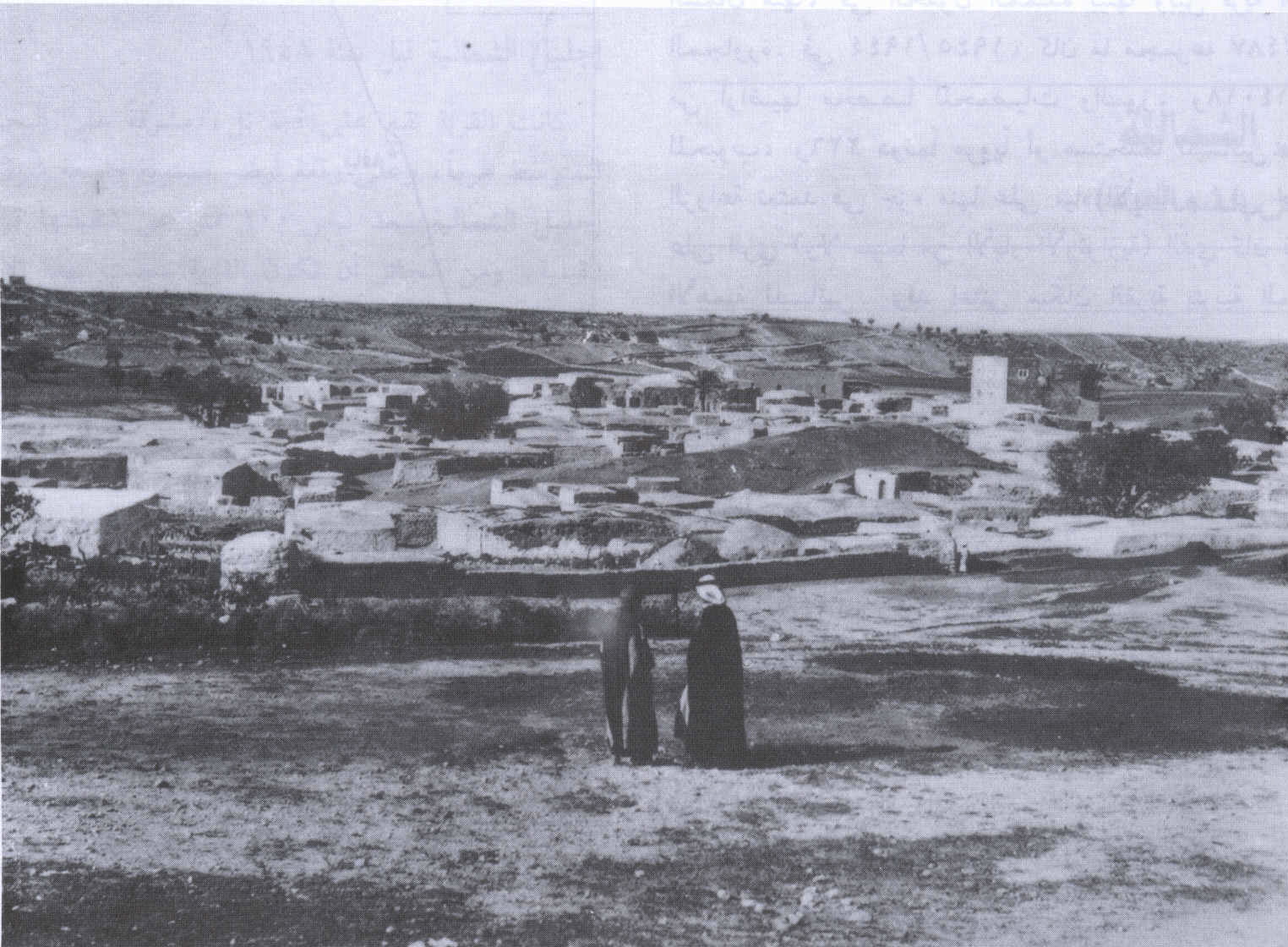
Bayt Dajan (Arabic: بيت دجن, romanized: Bayt Dajan; Hebrew: בית דג'ן), also known as Dajūn, was a Palestinian Arab village situated approximately 6 kilometers (3.7 mi) southeast of Jaffa. It is thought to have been the site of the biblical town of Beth Dagon, mentioned in the Book of Joshua and in ancient Assyrian and Ancient Egyptian texts. In the 10th century CE, it was inhabited mostly by Samaritans.
In the mid-16th century, Bayt Dajan formed part of an Ottoman waqf established by Roxelana, the wife of Suleiman the Magnificent, and by the late 16th century, it was part of the nahiya of Ramla in the liwa of Gaza. The villagers, who were all recorded as Muslim, paid taxes to the Ottoman authorities for property and agricultural goods and animal husbandry conducted in the villages, including the cultivation of wheat, barley, fruit, and sesame, as well as on goats, beehives and vineyards. In the 19th century, the village women were locally renowned for their intricate, high quality embroidery designs, a feature of traditional Palestinian costumes.
During the British Mandate, the village housed two elementary schools, a library and an agronomic school. After an assault by the Alexandroni Brigade during Operation Hametz on 25 April 1948 in the lead up to the 1948 Arab–Israeli war, the village was entirely depopulated. The Israeli town of Beit Dagan was founded at the same site in October 1948.
Another Bayt Dajan, not to be confused with this one, is located southeast of Nablus.
Bayt Dajan /Bēt Dajan/ is a Canaanite name that appears in standard Babylonian (in a Neo-Assyrian inscription from 701 BC) Bīt(É)-da-gan-na78 and [Bητ]οδεγανα on the Madaba Map.
The village is mentioned in Assyrian and Ancient Egyptian texts as "Bīt Dagana" and bet dgn, respectively. Its Arabic name, Bayt Dajan, preserves this ancient name.
Jerome describes the village in the 4th century CE as "very large", noting its name then as "Kafar Dagon" or "Caphardagon", situating it between Diospolis (modern Lod) and Yamnia (Yavne/Yibna). Bayt Dajan also appears on the 6th century Map of Madaba under the name [Bet]o Dagana.
The nearby site of Khirbet Dajūn, a tel with ruins to the southwest of Bayt Dajan, preserves the Dagon rather than Dagan spelling. In Arabic literature, there are many references to Dajūn, which was also used to refer to Bayt Dajan itself.
Bayt Dajan
Bayt Dajan (Arabic: بيت دجن, romanized: Bayt Dajan; Hebrew: בית דג'ן), also known as Dajūn, was a Palestinian Arab village situated approximately 6 kilometers (3.7 mi) southeast of Jaffa. It is thought to have been the site of the biblical town of Beth Dagon, mentioned in the Book of Joshua and in ancient Assyrian and Ancient Egyptian texts. In the 10th century CE, it was inhabited mostly by Samaritans.
In the mid-16th century, Bayt Dajan formed part of an Ottoman waqf established by Roxelana, the wife of Suleiman the Magnificent, and by the late 16th century, it was part of the nahiya of Ramla in the liwa of Gaza. The villagers, who were all recorded as Muslim, paid taxes to the Ottoman authorities for property and agricultural goods and animal husbandry conducted in the villages, including the cultivation of wheat, barley, fruit, and sesame, as well as on goats, beehives and vineyards. In the 19th century, the village women were locally renowned for their intricate, high quality embroidery designs, a feature of traditional Palestinian costumes.
During the British Mandate, the village housed two elementary schools, a library and an agronomic school. After an assault by the Alexandroni Brigade during Operation Hametz on 25 April 1948 in the lead up to the 1948 Arab–Israeli war, the village was entirely depopulated. The Israeli town of Beit Dagan was founded at the same site in October 1948.
Another Bayt Dajan, not to be confused with this one, is located southeast of Nablus.
Bayt Dajan /Bēt Dajan/ is a Canaanite name that appears in standard Babylonian (in a Neo-Assyrian inscription from 701 BC) Bīt(É)-da-gan-na78 and [Bητ]οδεγανα on the Madaba Map.
The village is mentioned in Assyrian and Ancient Egyptian texts as "Bīt Dagana" and bet dgn, respectively. Its Arabic name, Bayt Dajan, preserves this ancient name.
Jerome describes the village in the 4th century CE as "very large", noting its name then as "Kafar Dagon" or "Caphardagon", situating it between Diospolis (modern Lod) and Yamnia (Yavne/Yibna). Bayt Dajan also appears on the 6th century Map of Madaba under the name [Bet]o Dagana.
The nearby site of Khirbet Dajūn, a tel with ruins to the southwest of Bayt Dajan, preserves the Dagon rather than Dagan spelling. In Arabic literature, there are many references to Dajūn, which was also used to refer to Bayt Dajan itself.
Recent media
Recent media