Recent from talks
Cyclone Raja
Knowledge base stats:
Talk channels stats:
Members stats:
Cyclone Raja
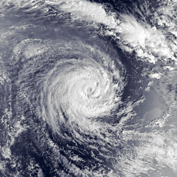
Severe Tropical Cyclone Raja was a tropical cyclone that holds the 24-hour rainfall record of 674.9 mm (26.57 in) for the French Overseas Territory of Wallis and Futuna. The system was first noted by the Fiji Meteorological Service (FMS) as a weak tropical disturbance northeast of Tokelau in mid-December 1986. The system developed further as it moved southwest over the next few days, and it was classified as Tropical Cyclone Raja on 23 December. The newly named system slowed and unexpectedly recurved southeast towards the French territory of Wallis and Futuna on 24 December. Over the next two days, Raja interacted with what would become Severe Tropical Cyclone Sally and executed a tight loop, passing within 55 km (35 mi) of Futuna. The system peaked as a Category 3 severe tropical cyclone on 28 December, with estimated 10-minute sustained winds of 90 mph (150 km/h). The storm turned southwest the next day and threatened Fiji, where it passed within 20 km (10 mi) of Vanua Levu and near (or over) several smaller islands in the Lau group during the following day. Raja gradually weakened over the next few days as it moved south of Fiji; it was last noted on 5 January 1987 after it filled up over the north Tasman Sea.
Raja caused one death as it impacted the island nations of Tuvalu, Wallis and Futuna, Tonga and Fiji. Gusty winds and rough seas associated with the system caused extensive damage to crops, coastal installations and buildings in Tuvalu, and flooded low-lying areas. The island of Futuna was the worst hit, with crops, coastal installations and buildings damaged or destroyed by the system. Raja affected the main islands of Fiji twice between 24 and 30 December, and was responsible for the worst flood of the Labasa River since 1929. As a result of the damage to Fiji and portions of Polynesia, the name Raja was retired from the South Pacific naming lists.
The South Pacific convergence zone was active in the middle of December 1986, with a mid-latitude upper-level trough of low pressure which extended into the tropics. A westerly wind burst between Tokelau and Kanton Island resulted in a tropical disturbance developing to the northeast of Tokelau. The Fiji Meteorological Service (FMS) began to monitor the disturbance as a shallow tropical depression on 21 December, when the system was about 280 km (175 mi) east of the island of Funafuti, Tuvalu. At that time, the system was beyond the range of any reporting stations; its circulation was weak and ill-defined, which meant that there was considerable uncertainty about the location of its center. The depression moved southwest and passed near the Tuvaluan atoll of Nukufetau, as it slowly deepened and organised over the next 36 hours.
After the system was named Tropical Cyclone Raja by the FMS on 23 December; the United States Naval Western Oceanography Center (NWOC) initiated advisories on the system and designated it as Tropical Cyclone 04P. During that day, the system slowed as it approached Rotuma; the subtropical ridge of high pressure weakened, and widespread falling pressure was recorded across the Pacific. Raja then unexpectedly re-curved southeast and began moving towards the French territory of Wallis and Futuna on 24 December. Satellite imagery the next day indicated that the system had developed an eye, and it passed within 55 km (35 mi) of Futuna. Raja reached hurricane strength on 26 December, as it slowed and began to interact with what would become Severe Tropical Cyclone Sally. Over the next two days, Raja approached to within 1,110 km (690 mi) of Sally in an anticlockwise cyclonic loop as it continued to intensify. The system also passed about 110 km (70 mi) southeast of Futuna, as it re-curved east and began to threaten Fiji.
The FMS estimated on 28 December that Raja had peaked with 10-minute sustained winds of 90 mph (150 km/h), which made it a Category 3 severe tropical cyclone on the Australian tropical cyclone intensity scale. The system turned southwest that day, in response to a trough of low pressure developing over (and south of) Raja and Sally. It passed within 20 km (10 mi) of Cikobia and Udu Point on Vanua Levu on 29 December, before it passed over or near several smaller Fijian islands in the Lau Group while beginning to turn south. The NWOC estimated that Raja had peaked in intensity at this time with one-minute sustained wind speeds of 105 mph (165 km/h), which made it equivalent to a Category 2 hurricane on the Saffir-Simpson hurricane wind scale. Over the next few days, Raja gradually weakened as it moved over cooler waters south of Fiji and its outflow became restricted before it degenerated into a depression during 1 January. The depression subsequently passed under a subtropical jet and moved west, where it became part of a blocking pattern over New Zealand. The system was last noted on 5 January, after filling over the north Tasman Sea.
Severe Tropical Cyclone Raja was responsible for a single death as it impacted Fiji and parts of Polynesia, before its name was later retired from the South Pacific lists of tropical cyclone names. When the FMS began monitoring Raja as a tropical depression on 21 December, they issued a tropical cyclone alert for Tuvalu. Although the system moved southwest and affected Tuvalu as expected, it failed to deepen as quickly as anticipated. However, its strong, gusty winds and high seas caused extensive damage to crops, coastal installations and buildings and flooded low-lying areas on the island nation.
Raja was expected to begin moving southeast after it passed near Rotuma on 24 December, which prompted the FMS to issue a tropical cyclone alert for the Tongan islands of Niuafoʻou and Keppel. Gale warnings were issued on 25 December for the two islands and remained in place until 28 December, when the system had turned southwest and moved well away from the islands. A tropical cyclone alert was issued for the islands of southern Tonga on 29 December, when the possibility arose that Raja would turn southeast and affect central and southern Tonga. A gale warning was subsequently issued for Tongatapu and the Nomuka group of islands before all warnings for Tonga were cancelled on 30 December.
Raja impacted the French overseas territory of Wallis and Futuna on 25–29 December, and was responsible for one death as well as extensive damage to the islands' crops, coastal installations and buildings. A storm warning was issued by the FMS for Futuna on 24 December and remained in place until 28 December while the system made a cyclonic loop near the island. The system brought gale-force winds to Wallis, and was thought to have brought hurricane-force winds to Futuna; this could not be verified since the weather station was blown down. It also generated high seas, flooding, landslides and a storm surge which damaged Futuna's grass airstrip. On 26 December, a record 24-hour rainfall total of 674.9 mm (26.57 in) and a minimum pressure of 969.2 hectopascals (28.62 inHg) were recorded at the Maopoopo weather station on Futuna. The Maopoopo station also recorded a wind gust of 133 km/h (83 mph) before its anemometer was destroyed, and a record wind gust of 137 km/h (85 mph) was recorded in Wallis' Hihifo District. The record was broken during Severe Tropical Cyclone Evan in December 2012, when a wind gust of 156 km/h (97 mph) was recorded at the Hihifo aerodrome.
Hub AI
Cyclone Raja AI simulator
(@Cyclone Raja_simulator)
Cyclone Raja
Severe Tropical Cyclone Raja was a tropical cyclone that holds the 24-hour rainfall record of 674.9 mm (26.57 in) for the French Overseas Territory of Wallis and Futuna. The system was first noted by the Fiji Meteorological Service (FMS) as a weak tropical disturbance northeast of Tokelau in mid-December 1986. The system developed further as it moved southwest over the next few days, and it was classified as Tropical Cyclone Raja on 23 December. The newly named system slowed and unexpectedly recurved southeast towards the French territory of Wallis and Futuna on 24 December. Over the next two days, Raja interacted with what would become Severe Tropical Cyclone Sally and executed a tight loop, passing within 55 km (35 mi) of Futuna. The system peaked as a Category 3 severe tropical cyclone on 28 December, with estimated 10-minute sustained winds of 90 mph (150 km/h). The storm turned southwest the next day and threatened Fiji, where it passed within 20 km (10 mi) of Vanua Levu and near (or over) several smaller islands in the Lau group during the following day. Raja gradually weakened over the next few days as it moved south of Fiji; it was last noted on 5 January 1987 after it filled up over the north Tasman Sea.
Raja caused one death as it impacted the island nations of Tuvalu, Wallis and Futuna, Tonga and Fiji. Gusty winds and rough seas associated with the system caused extensive damage to crops, coastal installations and buildings in Tuvalu, and flooded low-lying areas. The island of Futuna was the worst hit, with crops, coastal installations and buildings damaged or destroyed by the system. Raja affected the main islands of Fiji twice between 24 and 30 December, and was responsible for the worst flood of the Labasa River since 1929. As a result of the damage to Fiji and portions of Polynesia, the name Raja was retired from the South Pacific naming lists.
The South Pacific convergence zone was active in the middle of December 1986, with a mid-latitude upper-level trough of low pressure which extended into the tropics. A westerly wind burst between Tokelau and Kanton Island resulted in a tropical disturbance developing to the northeast of Tokelau. The Fiji Meteorological Service (FMS) began to monitor the disturbance as a shallow tropical depression on 21 December, when the system was about 280 km (175 mi) east of the island of Funafuti, Tuvalu. At that time, the system was beyond the range of any reporting stations; its circulation was weak and ill-defined, which meant that there was considerable uncertainty about the location of its center. The depression moved southwest and passed near the Tuvaluan atoll of Nukufetau, as it slowly deepened and organised over the next 36 hours.
After the system was named Tropical Cyclone Raja by the FMS on 23 December; the United States Naval Western Oceanography Center (NWOC) initiated advisories on the system and designated it as Tropical Cyclone 04P. During that day, the system slowed as it approached Rotuma; the subtropical ridge of high pressure weakened, and widespread falling pressure was recorded across the Pacific. Raja then unexpectedly re-curved southeast and began moving towards the French territory of Wallis and Futuna on 24 December. Satellite imagery the next day indicated that the system had developed an eye, and it passed within 55 km (35 mi) of Futuna. Raja reached hurricane strength on 26 December, as it slowed and began to interact with what would become Severe Tropical Cyclone Sally. Over the next two days, Raja approached to within 1,110 km (690 mi) of Sally in an anticlockwise cyclonic loop as it continued to intensify. The system also passed about 110 km (70 mi) southeast of Futuna, as it re-curved east and began to threaten Fiji.
The FMS estimated on 28 December that Raja had peaked with 10-minute sustained winds of 90 mph (150 km/h), which made it a Category 3 severe tropical cyclone on the Australian tropical cyclone intensity scale. The system turned southwest that day, in response to a trough of low pressure developing over (and south of) Raja and Sally. It passed within 20 km (10 mi) of Cikobia and Udu Point on Vanua Levu on 29 December, before it passed over or near several smaller Fijian islands in the Lau Group while beginning to turn south. The NWOC estimated that Raja had peaked in intensity at this time with one-minute sustained wind speeds of 105 mph (165 km/h), which made it equivalent to a Category 2 hurricane on the Saffir-Simpson hurricane wind scale. Over the next few days, Raja gradually weakened as it moved over cooler waters south of Fiji and its outflow became restricted before it degenerated into a depression during 1 January. The depression subsequently passed under a subtropical jet and moved west, where it became part of a blocking pattern over New Zealand. The system was last noted on 5 January, after filling over the north Tasman Sea.
Severe Tropical Cyclone Raja was responsible for a single death as it impacted Fiji and parts of Polynesia, before its name was later retired from the South Pacific lists of tropical cyclone names. When the FMS began monitoring Raja as a tropical depression on 21 December, they issued a tropical cyclone alert for Tuvalu. Although the system moved southwest and affected Tuvalu as expected, it failed to deepen as quickly as anticipated. However, its strong, gusty winds and high seas caused extensive damage to crops, coastal installations and buildings and flooded low-lying areas on the island nation.
Raja was expected to begin moving southeast after it passed near Rotuma on 24 December, which prompted the FMS to issue a tropical cyclone alert for the Tongan islands of Niuafoʻou and Keppel. Gale warnings were issued on 25 December for the two islands and remained in place until 28 December, when the system had turned southwest and moved well away from the islands. A tropical cyclone alert was issued for the islands of southern Tonga on 29 December, when the possibility arose that Raja would turn southeast and affect central and southern Tonga. A gale warning was subsequently issued for Tongatapu and the Nomuka group of islands before all warnings for Tonga were cancelled on 30 December.
Raja impacted the French overseas territory of Wallis and Futuna on 25–29 December, and was responsible for one death as well as extensive damage to the islands' crops, coastal installations and buildings. A storm warning was issued by the FMS for Futuna on 24 December and remained in place until 28 December while the system made a cyclonic loop near the island. The system brought gale-force winds to Wallis, and was thought to have brought hurricane-force winds to Futuna; this could not be verified since the weather station was blown down. It also generated high seas, flooding, landslides and a storm surge which damaged Futuna's grass airstrip. On 26 December, a record 24-hour rainfall total of 674.9 mm (26.57 in) and a minimum pressure of 969.2 hectopascals (28.62 inHg) were recorded at the Maopoopo weather station on Futuna. The Maopoopo station also recorded a wind gust of 133 km/h (83 mph) before its anemometer was destroyed, and a record wind gust of 137 km/h (85 mph) was recorded in Wallis' Hihifo District. The record was broken during Severe Tropical Cyclone Evan in December 2012, when a wind gust of 156 km/h (97 mph) was recorded at the Hihifo aerodrome.
Recent media