Hubbry Logo
TropicsTropicsMain
Open search
Tropics
Community hub
Tropics
logo
8 pages, 0 posts
0 subscribers
Be the first to start a discussion here.
Tropics
Tropics
from Wikipedia
World map with the intertropical zone highlighted in crimson
Areas of the world with tropical climates.
  Af
  Am
  Aw/As

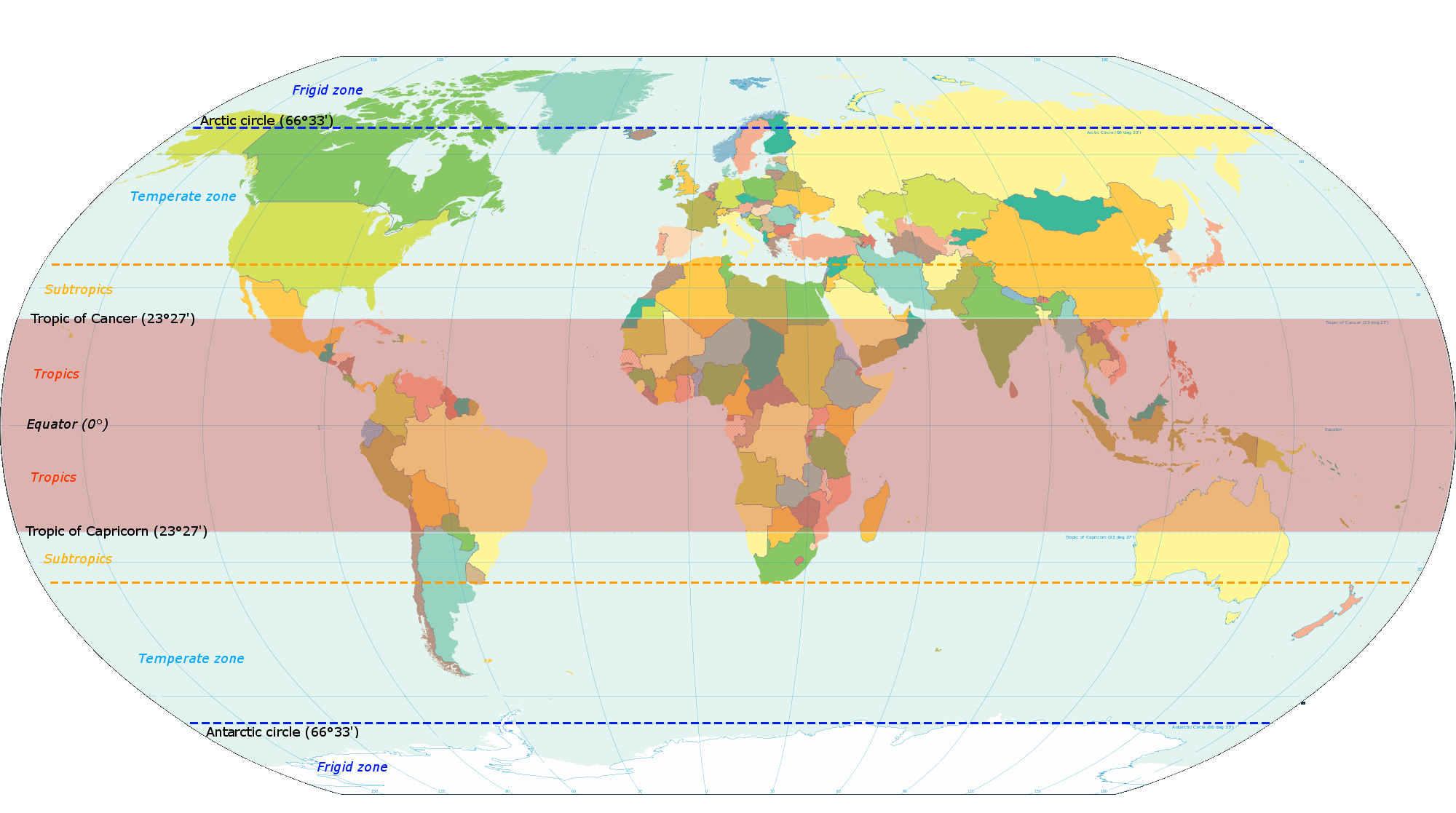
The tropics are the region of Earth surrounding the equator, where the sun may shine directly overhead. This contrasts with the temperate or polar regions of Earth, where the Sun can never be directly overhead. Because of Earth's axial tilt, the width of the tropics (in latitude) is twice the tilt. The tropics are also referred to as the tropical zone and the torrid zone (see geographical zone).

Due to the sun's high angle throughout the year, the tropics receive the most solar energy over the course of the year, and consequently have the highest temperatures on the planet. Even when not directly overhead, the sun is still close to overhead throughout the year, therefore the tropics also have the lowest seasonal variation on the planet; "winter" and "summer" lose their temperature contrast. Instead, seasons are more commonly divided by precipitation variations than by temperature variations or daylight hours.

The tropics maintain wide diversity of local climates, such as rain forests, monsoons, savannahs, deserts, and high altitude snow-capped mountains. The word "tropical" can specifically refer to certain kinds of weather, rather than to the geographic region; these usages ought not be confused.

The Earth's axial tilt is currently around 23.4°, and therefore so are the latitudes of the tropical circles, marking the boundary of the tropics: specifically, ±23°26′09.3″ (or 23.43593°). The northern one is called the Tropic of Cancer, and the southern is the Tropic of Capricorn. As the Earth's axial tilt changes,[a] so too do the tropical and polar circles.

The tropics constitute 39.8% of Earth's surface area[1] and contain 36% of Earth's landmass.[2] As of 2014, the region was home also to 40% of the world's population, and this figure was then projected to reach 50% by 2050. Because of global warming, the weather conditions of the tropics are expanding with areas in the subtropics,[3] having more extreme weather events such as heatwaves and more intense storms.[4][3] These changes in weather conditions may make certain parts of the tropics uninhabitable.[5]

Etymology

[edit]

The word "tropic" comes via Latin from Ancient Greek τροπή (tropē), meaning "to turn" or "change direction".[6]

Astronomical definition

[edit]
Relationship of Earth's axial tilt (ε) to the tropical and polar circles: the Tropic of Cancer is a subsolar point only at the June solstice, and the Tropic of Capricorn is only at the December solstice[7]

The tropics are defined as the region between the Tropic of Cancer in the Northern Hemisphere at 23°26′09.3″ (or 23.43593°) N and the Tropic of Capricorn in the Southern Hemisphere at 23°26′09.3″ (or 23.43593°) S;[8] these latitudes correspond to the axial tilt of the Earth.

The Tropic of Cancer is the Northernmost latitude from which the Sun can ever be seen directly overhead, and the Tropic of Capricorn is the Southernmost.[8] This means that the tropical zone includes everywhere on Earth which is a subsolar point at least once during the solar year. Thus the maximum latitudes of the tropics have equal distances from the equator on either side. Likewise, they approximate the angle of the Earth's axial tilt. This angle is not perfectly fixed, mainly due to the influence of the moon, but the limits of the tropics are a geographic convention, and their variance from the true latitudes is very small.

Seasons and climate

[edit]
Aerial view of Bora Bora in French Polynesia
Tropical sunset over the sea in Kota Kinabalu in Malaysia

Many tropical areas have both a dry and a wet season. The wet season, rainy season or green season is the time of year, ranging from one or more months when most of the average annual rainfall in a region falls.[9] Areas with wet seasons are disseminated across portions of the tropics and subtropics, some even in temperate regions.[10] Under the Köppen climate classification, for tropical climates, a wet-season month is defined as one or more months where average precipitation is 60 mm (2.4 in) or more.[11] Some areas with pronounced rainy seasons see a break in rainfall during mid-season when the Intertropical Convergence Zone or monsoon trough moves poleward of their location during the middle of the warm season;[12] Typical vegetation in these areas ranges from moist seasonal tropical forests to savannahs.

Graph showing the zonally averaged monthly precipitation. The tropics receive more precipitation than higher latitudes. The precipitation maximum, which follows the solar equator through the year, is under the rising branch of the Hadley circulation. The sub-tropical minima are under the descending branch and cause the formation of desert areas.

When the wet season occurs during the warm season, or summer, precipitation falls mainly during the late afternoon and early evening hours. The wet season is a time when air quality improves, freshwater quality improves and vegetation grows significantly due to the wet season supplementing flora, leading to crop yields late in the season. Floods and rains cause rivers to overflow their banks, and some animals to retreat to higher ground. Soil nutrients are washed away and erosion increases. The incidence of malaria increases in areas where the rainy season coincides with high temperatures. Animals have adaptation and survival strategies for the wetter regime. The previous dry season leads to food shortages into the wet season, as the crops have yet to mature.

However, regions within the tropics may well not have a tropical climate. Under the Köppen climate classification, much of the area within the geographical tropics is classed not as "tropical" but as "dry" (arid or semi-arid), including the Sahara Desert, the Atacama Desert and Australian Outback. Also, there are alpine tundra and snow-capped peaks, including Mauna Kea, Mount Kilimanjaro, Puncak Jaya and the Andes as far south as the northernmost parts of Chile and Peru.

Climate change

[edit]

The climate is changing in the tropics, as it is in the rest of the world.[13] The effects of steadily rising concentrations of greenhouse gases on the climate may be less obvious to tropical residents, however, because they are overlain by considerable natural variability. Much of this variability is driven by the El Niño-Southern Oscillation (ENSO). The Tropics has warmed by 0.7–0.8 °C over the last century—only slightly less than the global average—but a strong El Niño made 1998 the warmest year in most areas, with no significant warming since. Climate models predict a further 1–2 °C warming by 2050 and 1–4 °C by 2100.

Ecosystems

[edit]
Distribution of tropical wet forests

Tropical plants and animals are those species native to the tropics. Tropical ecosystems may consist of tropical rainforests, seasonal tropical forests, dry (often deciduous) forests, spiny forests, deserts, savannahs, grasslands and other habitat types. There are often wide areas of biodiversity, and species endemism present, particularly in rainforests and seasonal forests. Some examples of important biodiversity and high-endemism ecosystems are El Yunque National Forest in Puerto Rico, Costa Rican and Nicaraguan rainforests, Amazon rainforest territories of several South American countries, Madagascar dry deciduous forests, the Waterberg Biosphere of South Africa, and eastern Madagascar rainforests. Often the soils of tropical forests are low in nutrient content, making them quite vulnerable to slash-and-burn deforestation techniques, which are sometimes an element of shifting cultivation agricultural systems.

In biogeography, the tropics are divided into Paleotropics (Africa, Asia and Australia) and Neotropics (Caribbean, Central America, and South America). Together, they are sometimes referred to as the Pantropic. The system of biogeographic realms differs somewhat; the Neotropical realm includes both the Neotropics and temperate South America, and the Paleotropics correspond to the Afrotropical, Indomalayan, Oceanian, and tropical Australasian realms.

Flora

[edit]

Flora are plants found in a specific region at a specific time. Some well-known plants that are exclusively found in, originate from, or are often associated with the tropics include:

Tropicality

[edit]
Juruá River surrounded by the dense Amazon rainforest, which is home to uncontacted tribes to this day

Tropicality refers to the image of the tropics that people from outside the tropics have of the region, ranging from critical to verging on fetishism.[14] Tropicality gained renewed interest in geographical discourse when French geographer Pierre Gourou published Les pays tropicaux (The Tropical World in English), in the late 1940s.[15]

Tropicality encompassed two major images. One, is that the tropics represent a 'Garden of Eden', a heaven on Earth, a land of rich biodiversity or a tropical paradise.[16] The alternative is that the tropics consist of wild, unconquerable nature. The latter view was often discussed in old Western literature more so than the first.[16] Evidence suggests over time that the view of the tropics as such in popular literature has been supplanted by more well-rounded and sophisticated interpretations.[17]

Western scholars tried to theorise why tropical areas were relatively more inhospitable to human civilisations than colder regions of the Northern Hemisphere. A popular explanation focused on the differences in climate. Tropical jungles and rainforests have much more humid and hotter weather than colder and drier temperaments of the Northern Hemisphere, giving to a more diverse biosphere. This theme led some scholars to suggest that humid hot climates correlate to human populations lacking control over nature e.g. 'the wild Amazonian rainforests'.[18]

See also

[edit]

Notes

[edit]

References

[edit]
[edit]
Revisions and contributorsEdit on WikipediaRead on Wikipedia
from Grokipedia
The Tropics, or tropical zone, refers to the band of latitudes on centered on the and bounded by the at approximately 23.5° N and the at 23.5° S, where the Sun passes directly overhead at least once annually due to the planet's . This geographic definition encompasses about 40% of 's surface, characterized by high solar insolation year-round that drives intense atmospheric convection and minimal temperature seasonality. Tropical climates feature average temperatures exceeding 20°C with the coolest month above 18°C, fostering wet and dry variants influenced by the and monsoonal patterns, which deliver substantial annual in many areas—often over 2,000 mm. These conditions, rooted in the of and rotation, enable rapid and high , supporting ecosystems like rainforests that exhibit the highest net primary productivity among terrestrial biomes. Ecologically, the Tropics host over half of global terrestrial species and a disproportionate share of total , with stable warmth and resource abundance permitting evolutionary specialization and high species density unmatched at higher latitudes. This latitudinal in diversity arises from factors including extended geological stability and energetic constraints on , rather than simplistic energy availability alone. Human impacts, such as , now threaten these hotspots, underscoring the region's outsized role in planetary carbon cycling and .

Etymology and Conceptual History

Origins of the Term

The term tropics originates from the tropicus, borrowed from tropikos (τροπικός), an adjective meaning "pertaining to a turning" or "of the solstice," derived from tropē (τροπή), "a turning, change of direction, or solstitial point," ultimately from the verb trepein (τρέπω), "to turn." This etymology reflects the astronomical observation of the sun's apparent annual path reversing direction at the solstices, as viewed from , rather than any climatic connotation. In , the concept denoted the parallel circles of celestial where the sun achieves its maximum north (, or *Tropikos Καρκίνος) or south (, or *Tropikos Αιγόκερως) during the summer and winter solstices, respectively, marking the "turning points" of the sun's northward or southward progression. These lines were formalized in Hellenistic texts, such as those by astronomers like (c. 190–120 BCE), who calculated solar declinations to approximately 24° from the , though the term's application to terrestrial emphasized the solstitial zenith passages. The plural form tropics entered around the late 14th century via , initially referring specifically to these two solstitial parallels as astronomical boundaries. By the 1520s, its usage expanded to describe the equatorial zone between the (approximately 23.5° N) and (approximately 23.5° S), where the sun passes directly overhead twice annually, distinguishing it from temperate and polar regions based on solar geometry rather than alone. Early English texts, such as those in the English Dictionary's historical corpus, equated "tropical" signs with zodiacal points like Aries, Libra, , and Capricorn where the sun "turns back," underscoring the term's root in observable .

Historical Perceptions and Theories

In cosmology, the division of Earth into climatic zones emerged around the 6th century BCE, with philosopher proposing five parallel bands: a central between the tropics, flanked by two temperate zones and two frigid polar regions. This framework, building on Pythagoras's model, attributed the torrid zone's uninhabitability to excessive solar heat from the sun's perpetual overhead position, rendering it a barren, scorching expanse unfit for human life. Aristotle, in the 4th century BCE, refined this into three primary zones—torrid (equatorial), temperate (mid-latitudes), and frigid (polar)—emphasizing the torrid region's extreme and heat due to direct, year-round solar rays perpendicular to the surface, which he contrasted with the oblique angles in higher latitudes that moderated temperatures. He posited that this intense insolation evaporated moisture and scorched the land, preventing and settlement, a view echoed in later Hellenistic texts portraying the zone as a realm of mythical horrors like serpentine men and viper-eating troglodytes. Such perceptions stemmed from limited empirical observation, as Greek explorers like described distant tropical-like areas (e.g., ) as oppressively hot due to a flat-Earth assumption and rising sun's proximity to watery horizons, rather than rigorous latitudinal analysis. By the Roman era and into medieval Islamic scholarship, these theories persisted, with Ptolemy's 2nd-century CE Geography mapping the torrid zone as impassable, its heat allegedly liquefying humors and fostering degeneracy, influencing climatic where environment shaped human —tropical dwellers seen as indolent or from enervating warmth. European Age of Exploration from the challenged this, as voyages by Columbus (1492) and Magellan (1519–1522) revealed populous, viable societies in the and Pacific, disproving blanket uninhabitability and prompting revisions like those in 16th-century texts acknowledging equatorial despite monsoonal deluges and fevers, though myths of tropical torpor lingered in colonial rationales for European superiority. Enlightenment-era theories shifted toward mechanistic explanations, with Montesquieu's 1748 The Spirit of the Laws invoking heat's causal role in diluting societal vigor, yet empirical data from naturalists like (late 18th–early ) quantified solar forcing via isolines of and , laying groundwork for modern bioclimatic models while debunking deterministic extremes through altitudinal and oceanic variations within the tropics. These historical views, often biased by ethnocentric temperateness as normative, underscore a transition from speculative zonation to observationally grounded causal realism in understanding tropical dynamics.

Definitions and Boundaries

Astronomical Definition

The astronomical definition of the tropics delineates the latitudinal band on Earth where the Sun reaches a position—directly overhead at noon—at least once during the year. This zone is bounded by the , approximately 23.44° north of the , and the , approximately 23.44° south of the . These boundaries correspond precisely to the current obliquity of the , the tilt of 's rotational axis relative to its , which stands at 23.436° as of late 2025. The marks the northern limit where the Sun is zenithal on the , while the indicates the southern limit for the , reflecting the seasonal extremes of solar declination driven by . This definition stems from : the tropics encompass all latitudes experiencing subsolar points, where incoming solar rays are perpendicular to the surface. , with a cycle of about 26,000 years, shifts the timing of solstices relative to but does not alter the latitudinal boundaries, which are governed solely by obliquity. Over millennial timescales, obliquity oscillates between 22.1° and 24.5° in a 41,000-year cycle due to gravitational perturbations from the Sun, , and planets, thereby causing gradual northward or southward migration of the tropical parallels by up to 1.2° from present values. Such variations influence the geographic extent of perpetual midday solar positions but remain imperceptible on timescales.

Climatic and Ecological Definitions

Climatic definitions of the tropics emphasize temperature consistency that eliminates frost risk and enables year-round growth. The predominant criterion, established in the Köppen-Geiger system, designates tropical climates as those in which the mean temperature of the coldest month is at least 18°C (64°F), with all months meeting or exceeding this threshold. This standard arises from empirical observations of vegetation limits, as temperatures below 18°C typically induce or damage in tropical-adapted . Within this framework, subtypes such as (Af), (Am), and (Aw/As) are further distinguished by annual precipitation exceeding potential evapotranspiration, with dry seasons defined by months receiving less than 60 mm of rain. These climatic boundaries often extend beyond the astronomical tropics of Cancer and Capricorn, incorporating subtropical margins where persistent warmth prevails, such as parts of or southern , based on long-term meteorological data from 1991–2020. Precipitation regimes play a secondary role, with wet tropics requiring over 2000 mm annually to sustain dense vegetation, while drier variants support grasslands amid seasonal droughts. Ecologically, the tropics are characterized by biomes featuring broadleaf forests, mangroves, and savannas that exploit constant for high net primary productivity, often exceeding 2000 g/m²/year in rainforests. These ecosystems exhibit peak , with gradients increasing toward the due to stable conditions minimizing and maximizing opportunities over geological timescales. Boundaries are functionally set by physiological tolerances of dominant and to minimal temperature fluctuations and absence of killing frosts, aligning closely with climatic zones but varying with and —highland areas like the may host temperate enclaves within latitudinal tropics. Causal drivers include elevated insolation and fostering complex food webs and niche partitioning, though human alterations like can shift effective ecological limits.

Variations and Overlaps

The astronomical definition of the tropics, bounded by the Tropics of Cancer and Capricorn at approximately 23.44° north and south latitudes, relies on solar geometry where the sun passes directly overhead at least once annually. In contrast, climatic definitions emphasize thermal thresholds, such as the Köppen-Geiger classification's climates, where the mean temperature of the coldest month exceeds 18°C (64°F), leading to a zone that roughly aligns with but deviates from the astronomical band due to local factors like ocean currents and . Ecological definitions further vary by focusing on suitability, such as the prevalence of broadleaf forests requiring consistent warmth and moisture, which can contract the effective tropical zone equatorward in drier or elevated interiors while expanding it in coastal margins. These variations result in mismatches; for instance, high-altitude plateaus within the astronomical tropics, like parts of the above 2,000 meters, exhibit temperate or even alpine conditions with average coldest-month temperatures below 18°C, disqualifying them from climatic tropical status despite their . Conversely, low-elevation coastal areas poleward of 23.44°, such as southern (around 25–26°N) or Hawaii's leeward coasts, sustain tropical or climates (Köppen Aw/Am) due to maritime moderation preventing , extending the climatic tropics beyond astronomical limits by 1–3 degrees of in select locales. Ecological overlaps amplify this, as tropical flora like mangroves or certain palms can thrive in subtropical fringes with adequate rainfall, blurring boundaries in regions like the northern Australian wet-dry tropics transitioning to subtropical eucalypt woodlands. Overlaps with subtropics are particularly pronounced in transitional latitudes (roughly 23–35°), where definitions intersect: humid subtropical climates (Köppen Cfa/Cwa) feature hot summers akin to tropics but winters cool enough for occasional frosts (below 0°C no more than once per decade on average), yet share ecological traits like semi-evergreen in moist variants. These zones, often termed "marginal tropics," exhibit hybrid characteristics, such as the Mediterranean-influenced of or the monsoon of southeastern , where tropical cyclones influence weather patterns similar to core tropics. Such overlaps challenge rigid boundaries, with empirical data from 1991–2020 Köppen updates showing climatic tropical extents shifting poleward by up to 0.5° per decade in some ocean-adjacent areas due to warming trends, potentially widening discrepancies with the static astronomical frame. ![Köppen-Geiger climate classification map (1991–2020), illustrating climatic tropical zones (A) relative to astronomical boundaries][center]

Physical Characteristics

Geographical Extent

The tropics comprise the latitudinal band extending from the Tropic of Cancer at 23°26′ N to the Tropic of Capricorn at 23°26′ S, encompassing regions where the Sun passes directly overhead at least once during the year. This demarcation arises from Earth's axial tilt of approximately 23.44 degrees relative to its orbital plane, positioning these parallels as the northernmost and southernmost latitudes receiving perpendicular solar rays on the summer solstices. The total span covers about 47 degrees of latitude, representing roughly 40 percent of Earth's surface area. This zone includes significant portions of all continents except , with land accounting for 36 percent of global terrestrial surface within the tropics. Major landmasses encompassed include central and northern , sub-Saharan , , northern , and Pacific island groups, alongside vast oceanic expanses such as the equatorial Atlantic, Pacific, and Indian Oceans. The boundaries' precise positions vary slightly over millennia due to changes in Earth's obliquity, which oscillates between 22.1 and 24.5 degrees over a 41,000-year cycle, though the current value has remained stable near 23.4 degrees for recent centuries.

Topography and Geology

The topography of the tropics spans elevations from sea level to over 6,000 meters, encompassing vast sedimentary basins, rugged orogenic belts, rift valleys, and insular archipelagos. Lowland regions, such as the Amazon and Congo basins, cover millions of square kilometers of relatively flat terrain dissected by meandering rivers and subject to periodic flooding, underlain by thick sedimentary deposits atop basement. In contrast, high-relief areas include the , where peaks like in exceed 6,200 meters, formed through ongoing compressional . Geologically, tropical continental cores are dominated by ancient Precambrian cratons, including the in and the in , which stabilized between 2.5 and 1.0 billion years ago and exhibit low seismic activity due to their rigid lithospheric roots extending over 200 km deep. These cratons form the stable platforms for peripheral mobile belts where orogenies have added younger terrains. Active plate boundaries within tropical latitudes drive deformation, as seen in the , resulting from the of the Nazca Plate beneath at rates of 6-10 cm per year, producing fold-thrust belts, magmatic arcs, and associated mineral deposits. The exemplifies in the tropics, a 3,000-km-long feature involving lithospheric thinning, normal faulting, and alkaline volcanism, with basins filled by alluvial and lacustrine sediments. In oceanic and marginal settings, subduction-related volcanic arcs, such as the in , generate chains of stratovolcanoes and associated geothermal activity, contributing to island formation and high weathering rates in humid environments. Coastal tropics feature biogenic landforms like fringing reefs and atolls, constructed on subsided volcanic pedestals through accumulation over millions of years. This geological diversity underlies the region's ecological complexity and resource endowments, including hydrocarbons in basins and metals in orogenic zones.

Climate Patterns

Temperature and Seasons

The tropical regions exhibit consistently high temperatures throughout the year, with monthly averages typically ranging from 25°C to 28°C (77°F to 82°F), due to the near-overhead position of the sun at least once annually within the latitudes of 23.5°N to 23.5°S. This results from Earth's axial tilt of approximately 23.5°, which ensures that solar insolation remains intense and relatively uniform across seasons, as the sun's zenith path stays close to equatorial overhead positions rather than shifting dramatically as in higher latitudes. In contrast to temperate zones, where annual temperature swings can exceed 20°C, tropical areas experience minimal seasonal variation, often less than 5°C between the warmest and coolest months, with all months maintaining means above 18°C. Diurnal temperature fluctuations dominate over annual cycles in the tropics, with daytime highs frequently reaching 30°C to 35°C (86°F to 95°F) under clear skies, while nighttime lows rarely drop below 22°C (72°F) due to atmospheric moisture and limiting . Empirical data from tropical stations, such as those in wet climates like , confirm average ranges of 21°C to 30°C (70°F to 86°F) year-round, with cloudiness during wet periods further stabilizing temperatures by absorbing and re-emitting longwave radiation. In drier tropical subtypes, such as regions, maximum temperatures can peak above 35°C during dry seasons when reduced allows greater solar heating, but even here, the annual range remains subdued compared to extratropical areas. Seasons in the tropics are primarily distinguished not by temperature contrasts but by shifts in driven by the migration of the (ITCZ), leading to wet and dry periods rather than hot and cold ones. For instance, in tropics, wet seasons align with May to ITCZ positioning, during which increased cloudiness moderates daytime highs by 2–3°C relative to drier months, while wet periods occur from to . This -driven results in slight thermal enhancements during dry phases—up to 1–2°C warmer on average—owing to lower and clearer skies, but overall, the thermal regime remains equable, with the sun's consistent high-angle input overriding tilt-induced variations. Such patterns underscore the tropics' role as a reservoir, exporting energy poleward via to balance global imbalances.

Precipitation Regimes

The precipitation regimes of the tropics are dominated by convective processes arising from the consistent high insolation, which promotes from abundant and vegetation, leading to and frequent thunderstorms. Annual totals in tropical regions often exceed 1,500 mm, with two-thirds of global rainfall concentrated between 23.5°S and 23.5°N due to the low-latitude energy surplus driving upward motion. This contrasts with higher latitudes, where subsidence limits rainfall; causal mechanisms include the release of from condensation, which reinforces vertical circulation cells like the Hadley cells. Central to these regimes is the (ITCZ), a narrow band of enhanced where opposing meet, producing a zonal maximum in that migrates seasonally with the solar declination—typically 5–10° north of the in boreal summer and south in austral summer. In the , this shift brings wet seasons from May to July, while in the , they occur from to , with daily rainfall rates often surpassing 10 mm in active phases due to organized mesoscale systems. Equatorial zones experience near-constant ITCZ influence, yielding bimodal or aseasonal patterns with minimal monthly variation (rarely below 60 mm), as in parts of the where wet-season peaks exceed 200 mm monthly from to May. Monsoonal circulations represent an extension of ITCZ dynamics, featuring seasonal wind reversals driven by differential land-sea heating: summer flows draw moist maritime air inland, concentrating 70–90% of annual rainfall in 3–4 months, as observed in the domain where totals reach 2,000–5,000 mm. These regimes differ from pure ITCZ-driven ones by stronger orographic enhancement over continental interiors and coastlines. In savanna-like margins, prolonged dry seasons emerge where the ITCZ withdraws fully, with dropping below 60 mm for several months, enabling grass-dominated ecosystems but heightening risk; for instance, northern Australian savannas receive 800–1,500 mm annually, skewed toward summer. Spatial variations reflect and ocean currents: windward coastal slopes intercept trade-wind , amplifying orographic rainfall up to 10,000 mm yearly in Hawaiian peaks, while rain shadows produce drier pockets. Observational data from satellite gauges confirm these patterns, with zonal means peaking at 6–8 mm/day near 10° during solstices, modulated by phenomena like El Niño, which shifts the ITCZ southward and suppresses eastern Pacific rainfall by 20–50%. Empirical reconstructions underscore the ITCZ's paleo-position as a proxy for hemispheric energy balance, with southward biases during cooler periods.

Extreme Weather Events

The tropics experience a disproportionate share of tropical cyclones, which derive their energy from sea surface temperatures consistently above 26.5°C, enabling in regions of low vertical . Globally, an average of 80 to 90 tropical storms form each year, with approximately 40 to 50 reaching hurricane-strength winds of at least 119 km/h, predominantly in tropical basins such as the Atlantic, eastern Pacific, and western Pacific. In 2022, 88 named storms occurred worldwide, near the 1991-2020 climatological average, while 2024 saw 86 such systems, also aligning closely with norms. Tropical cyclone intensity, measured by sustained wind speeds and central pressure, peaks in Category 5 storms with winds over 252 km/h, capable of devastating coastal and through , high winds, and torrential rainfall exceeding 500 mm in 24 hours. Observational records indicate no upward trend in the frequency of intense (Category 3+) Atlantic hurricanes over the past five decades, though model projections suggest a potential 1-10% increase in global peak intensities under 2°C warming scenarios driven by thermodynamic effects on . These events account for substantial economic losses; for example, U.S. billion-dollar disasters from 1980-2024 include numerous tropical cyclone impacts, with cumulative costs adjusted to 2024 dollars surpassing hundreds of billions. Beyond cyclones, monsoon regimes produce extreme precipitation events leading to pluvial floods, where seasonal shifts in the deliver over 1,000 mm of rain in weeks, overwhelming river systems in regions like and . Compound events, such as cyclones coinciding with s, exacerbate flooding, as documented in IPCC assessments of regional extremes. Tropical droughts, often linked to anomalous warming like El Niño, have intensified in variability, with events in the amplifying atmospheric CO2 growth rates through reduced vegetation uptake. Heatwaves in the tropics, while less sharply defined than in extratropical zones due to perennial high temperatures, compound with droughts to elevate river degradation and stress globally, with empirical analyses showing worsened conditions for most constituents during such episodes. Flash droughts paired with extreme heat exhibit 6.7-90.8% higher severity and prolonged recovery times compared to isolated . These phenomena underscore the tropics' vulnerability to interconnected extremes, where ocean-atmosphere interactions drive both intensification and spatial clustering.

Ecosystems and Biodiversity

Major Biomes and Habitats

The tropics encompass a range of biomes shaped primarily by consistent high temperatures above 18°C year-round and regimes that vary from perpetually wet to strongly seasonal, fostering habitats from closed-canopy forests to open woodlands. These biomes, including tropical rainforests, dry forests, savannas, and coastal mangroves, support disproportionate despite covering roughly 40% of Earth's land surface between the Tropics of Cancer and Capricorn. Tropical rainforests, the most iconic tropical , occur in equatorial zones with annual rainfall exceeding 1,800–2,500 mm and no month drier than 60 mm, resulting in multilayered canopies of broad-leaved trees up to 50 meters tall, nutrient-poor soils reliant on rapid nutrient cycling via leaf litter, and exceptional —potentially 50% of terrestrial species in just 6–7% of land area. Concentrated in the (covering about 5.5 million km²), (1.8 million km²), and Indo-Malayan regions, these forests feature high humidity, limited seasonality, and adaptations like buttress roots and epiphytes to maximize light capture in shaded understories. Tropical dry forests, transitional between rainforests and savannas, prevail in regions 10°–25° with pronounced dry seasons (3–6 months of low rainfall below 100 mm/month) and total annual of 750–1,500 mm, supporting trees that shed leaves to conserve water, thorny shrubs, and grasses on more fertile, leached soils. Distributed across fragmented patches in (harboring the largest extent), , , , and , this biome spans approximately 519,597 km² in the alone, with global coverage estimated at 40–50% of all tropical forests but facing higher rates due to . Tropical savannas, or wet-dry grasslands, dominate in areas 8°–20° from the with 500–1,500 mm annual rainfall concentrated in a 4–6 month followed by , yielding landscapes of continuous tall grasses (up to 3–4 meters) interspersed with fire-resistant trees like acacias and baobabs, adapted to frequent wildfires and herbivory that prevent forest encroachment. Extensive in (e.g., covering 1 million km²), , and South America's , savannas exhibit nutrient-rich soils from grass decomposition but vulnerability to and climate shifts. Mangrove habitats fringe tropical coastlines in intertidal zones of brackish to saline waters, featuring salt-excreting trees and shrubs (e.g., species) with prop roots for stability in soft sediments, annual rainfall often exceeding 1,000 mm, and temperatures above 20°C. Occurring in over 123 countries along sheltered estuaries and deltas, cover about 137,000–152,000 km² globally, providing critical nurseries for fisheries (supporting 75% of commercial ), carbon sequestration (up to 4 times higher than terrestrial forests per area), and coastal protection against and storms.

Floral Diversity

Tropical regions encompass a disproportionate share of global floral diversity, hosting the majority of the estimated 500,000 land plant species worldwide, with concentrations driven by consistently warm temperatures, ample , and high that enable specialized adaptations and . Tropical rainforests, in particular, account for approximately 50% of species despite covering only about 6% of Earth's land surface, fostering environments where up to 400 tree species can coexist in a single . This richness arises from ecological stability over geological timescales, allowing for niche partitioning among s, including angiosperms, gymnosperms, ferns, and bryophytes, with exhibiting over twice the species of in a comparable area. Prominent plant families underscore this diversity, such as Orchidaceae, with tens of thousands of species predominantly in tropical habitats, exemplifying epiphytic and pollinator-specific adaptations; (palms), ubiquitous across tropical rainforests for structural dominance in understories and canopies; and , contributing nitrogen-fixing vital to in nutrient-poor tropical soils. In the , verified checklists reveal over 7,000 species of shrubs, small trees, lianas, vines, and herbs alone, comprising more than half of regional diversity and highlighting contributions to overall floristics. rates are elevated, particularly in montane tropics like the , where 50-60% of plant species are unique to the region, reflecting isolation and varied microclimates that promote . Floral composition varies by , with lowland rainforests showing higher endemicity (up to 85% shared pools) compared to montane forests, where elevation gradients introduce cooler-adapted . Across closed-canopy tropical forests, just 1,053 account for half of the estimated 800 billion trees, indicating oligarchic dominance by common genera amid vast rare- pools that sustain resilience but face threats from . These patterns, documented through georeferenced databases like RAINBIO for (22,577 across growth forms), affirm tropics as primary repositories of plant evolutionary , though systematic under-sampling in remote areas suggests actual diversity may exceed current estimates.

Faunal Adaptations and Endemism

Tropical exhibit specialized adaptations to the consistent warmth, high , and abundant rainfall characteristic of the region, which foster dense vegetation and intense interspecies . Many animals, such as arboreal and , have evolved prehensile tails or adhesive pads for navigating complex canopy structures, enabling efficient movement and foraging in vertically stratified habitats. Dietary niche partitioning is prevalent, with like certain fruit bats specializing in or to reduce in resource-rich but contested environments. In response to elevated predation pressures from diverse carnivores and parasites, adaptations include cryptic , as seen in sloths whose algae-covered blends with mossy branches, and slow metabolic rates that minimize detection and energy needs. sequestration in amphibians like poison dart frogs deters predators, leveraging the tropics' chemical diversity from plants and microbes. High biodiversity drives further defenses, such as among unpalatable insects, where convergent warning colorations signal toxicity to shared predators, enhancing survival in predator-saturated ecosystems. Reproductive strategies emphasize quantity over , with species like and producing thousands of eggs annually to offset high juvenile mortality from density-dependent factors. Enhanced sensory adaptations, including expanded neck vertebrae in sloths allowing 270-degree head rotation, facilitate vigilance in omnidirectional threat environments. Endemism in tropical fauna is pronounced, with stable climatic conditions over millennia promoting and limiting dispersal, particularly in isolated refugia like montane forests and islands. The alone host over 670 endemic , representing more than two-thirds of the region's total, due to topographic barriers fostering allopatric divergence. Globally, tropical islands exhibit endemism rates up to 9.5 times higher than continental areas for vertebrates, driven by vicariance and founder effects. In Southeast Asian tropics, approximately 50,000 animal occur, with ongoing discoveries averaging 364 per year, many confined to endemism hotspots. These patterns underscore the tropics' role as evolutionary cradles, though exacerbates vulnerability for narrow-range endemics.

Human Interactions and Impacts

Population Distribution and Urbanization

Approximately 40% of the world's population resides within the tropical zone, encompassing over 3 billion people as of 2022, with projections indicating that more than half of global inhabitants will live there by 2050 due to sustained high rates and net migration patterns. densities vary significantly, reaching highs in humid subtropical and tropical wet zones—often exceeding those in arid or polar regions—owing to fertile alluvial plains, river basins like the Amazon and , and coastal lowlands that support intensive and fisheries. In contrast, densities remain low in inland equatorial rainforests and mountainous interiors due to challenging terrain, poor soil accessibility, and limited . Urbanization in tropical regions lags behind the global average but has accelerated markedly, with the proportion of tropical residents in urban areas rising from 30% in 1980 to 47% by 2018, compared to the worldwide rate of approximately 56% in recent years. This growth stems primarily from rural-to-urban migration driven by opportunities in nascent , services, and informal sectors, alongside natural increases outpacing rural land capacity; empirical studies in and document annual urban expansion rates of 3-5% in major centers. Countries with significant tropical land coverage, such as and , saw urban populations reach 39% of their totals by 2015, fueling the emergence of megacities like (over 10 million inhabitants) and (around 15 million). Tropical urbanization manifests unevenly, with over 80% of new urban dwellers settling in low- to middle-income areas prone to and inadequate services, as coastal and riverine sites attract density due to trade access despite flood vulnerabilities. In , urban growth rates have outpaced all continents since the 1970s, reaching 4-5% annually in tropical nations, propelled by agricultural displacing rural labor and limited interventions to retain countryside populations. This pattern underscores a causal link between demographic pressures and geographic pull factors, though institutional factors like quality influence settlement quality more than alone.

Agriculture, Resources, and Land Use

Tropical agriculture primarily consists of subsistence farming and cash crop plantations, with key staples including cassava, rice, bananas, and yams, alongside export-oriented commodities such as oil palm, cocoa, coffee, and rubber. In 2023, global production of primary crops, many of which are tropical, reached 9.9 billion tonnes, reflecting a 27 percent increase since 2010, though tropical yields often lag due to environmental constraints. The Americas dominate in sugarcane (51 percent of world total) and maize (50 percent) production as of 2022, both integral to tropical systems. Tropical soils, typically highly weathered and nutrient-poor with low and high acidity, pose significant fertility challenges, necessitating practices like to allow periods for nutrient replenishment through natural regeneration. , involving forest clearing, short-term cropping, and extended fallows, maintains in low-intensity systems but degrades it when fallow lengths shorten due to population pressure, reducing carbon and nutrient stocks. Intensification efforts, such as or fertilizers, aim to sustain productivity, yet empirical data show variable success amid pest pressures and erratic rainfall. Natural resources in tropical regions include abundant timber from rainforests, substantial oil and natural gas reserves (e.g., in and ), and diverse minerals such as , , and concentrated in and . Timber extraction supplies global markets but often precedes agricultural conversion, while mineral and hydrocarbon mining disrupts ecosystems, with unsustainable practices exacerbating habitat loss. Land use in the tropics is dominated by agricultural expansion, which drives over 90 percent of deforestation, primarily for commodities like soy, cattle pasture, and palm oil, with only about half of cleared land becoming productive farmland due to abandonment or low yields. Between 1980 and 2000, more than 80 percent of new tropical agricultural land derived from rainforest clearance, reflecting patterns of smallholder shifting systems transitioning to large-scale plantations. Sustainable land management remains challenged by weak governance, though data indicate that geography alone does not preclude intensification when institutions support it.

Deforestation and Habitat Alteration

Tropical constitutes the predominant form of global loss, accounting for approximately 95% of total deforestation, with primary drivers rooted in . Between 1990 and 2020, an estimated 420 million hectares of were lost worldwide, the majority in tropical regions. Annual rates have declined from 17.6 million hectares in 1990–2000 to 10.9 million hectares in 2015–2025, yet tropical primary loss remains substantial, exacerbated by fires and commodity production in 2024. In , particularly the , cattle ranching and soybean cultivation drive over 80% of , converting vast tracts into pastures and croplands; alone lost 1.7 million hectares of tree cover in 2023. experiences high rates linked to palm oil plantations and , with and contributing 28% of tropical losses through commercial and infrastructure. In , the saw a 12.5% increase in in 2023 compared to 2018–2020 baselines, fueled by subsistence farming, , and selective that fragments habitats. These activities often involve slash-and-burn practices, which degrade and perpetuate cycles of further clearing. Habitat alteration extends beyond outright removal, manifesting in forest fragmentation that creates isolated patches vulnerable to , such as increased wind exposure, ingress, and shifts. In highly deforested landscapes, remaining fragments exhibit reduced canopy integrity and diversity, amplifying collapse; for instance, Amazonian fragments in deforested areas show diminished functionality. This fragmentation disrupts migratory corridors and networks, leading to localized extinctions; studies indicate that 95% of Amazon species have been exposed to fire-impacted areas since 2001, totaling 40,000 to 73,400 square miles affected. The resultant impacts are profound, with habitat loss directly correlating to declines and heightened risks, particularly for endemics reliant on contiguous interiors. Tropical reduces overall by altering food webs and resource availability, while biophysical effects like decreased contribute to drier regional conditions, further stressing habitats. Weak enforcement in tropical nations, often due to challenges rather than solely external demand, sustains these trends despite international pledges.

Economic and Developmental Aspects

Resource Extraction and Trade

The tropics host substantial reserves of fossil fuels, with crude oil extraction concentrated in equatorial basins such as the in , the in , and offshore fields in . In 2023, global crude oil production averaged 81.8 million barrels per day, with tropical producers like contributing around 1.4 million barrels per day, primarily from shallow-water and onshore operations vulnerable to and spills. , another key player, produced approximately 600,000 barrels per day, supplemented by from fields like the , which together form over 20% of the country's export revenues. These resources are traded as raw commodities on global markets, with exports routed through ports like in or in , often facing logistical bottlenecks from inadequate infrastructure. Mineral extraction drives significant economic activity in tropical Africa and , where deposits of , , and underpin battery and aluminum industries. The (DRC), spanning the equatorial zone, accounted for over 70% of global output in 2023, producing roughly 170,000 metric tons from artisanal and industrial mines in , amid reports of hazardous labor conditions and opacity. production in tropical reached 700,000 metric tons that year, extracted via underground methods in the , with exports valued at billions supporting foreign exchange. mining in , a tropical West African nation, yielded over 100 million metric tons in 2023, shipped primarily to and for alumina refining, representing more than 90% of Guinea's export earnings despite limited domestic processing. These minerals are exported in or form, with flows dominated by bulk carriers to industrialized importers, exacerbating dependency on volatile commodity prices. Renewable biological resources, including timber and palm oil, form another pillar of tropical extraction and trade. Industrial logging in Indonesian and Brazilian rainforests contributed to 3.7 million hectares of primary tropical forest loss in 2023, yielding sawnwood and plywood exports valued at over $10 billion annually from Southeast Asia alone, per International Tropical Timber Organization data. Palm oil, derived from plantations across equatorial belts, saw Indonesia produce 46 million metric tons of crude palm oil in 2023, with exports exceeding 30 million tons shipped to India and Europe for food, fuel, and cosmetics, generating $20-25 billion in revenue. Malaysia added 19.4 million metric tons, its shipments totaling 15.1 million tons that year, underscoring the sector's role in funding infrastructure but also linked to land conversion pressures. Trade in these goods relies on riverine and coastal transport, with value chains often exporting unprocessed materials to temperate-zone refiners, limiting local industrialization.

Challenges to Growth: Geography vs. Institutions

Tropical regions face persistent economic , with average GDP in tropical countries standing at approximately $3,326 in 1995, compared to higher levels in non-tropical nations, prompting debate over whether inherent geographical factors or institutional quality primarily constrain growth. Proponents of geographical determinism, such as , argue that tropical climates impose structural barriers including high disease prevalence, nutrient-poor soils, and erratic precipitation patterns that hinder and formation. For instance, malaria's endemic presence in and correlates with a 1.3% annual reduction in due to morbidity and mortality effects on labor productivity. These endowments limit the suitability of high-yield crops like and , favoring lower-productivity staples such as and yams, while high humidity fosters pests and pathogens that degrade infrastructure and health outcomes. Empirical analyses using geographic information systems (GIS) reveal spatial clustering of in tropical lowlands, where below 1,000 meters exacerbates stress and vector-borne diseases, contrasting with higher-altitude or temperate zones that historically supported denser populations and technological . Cross-country regressions incorporating variables like land area in tropics as a proxy for find a negative association with GDP , even after controlling for factors, suggesting geography's independent role in suppressing and . Higher temperatures in tropical zones also correlate with reduced economic output, as evidenced by subnational data showing a 1% GDP decline per degree increase in average temperature. Counterarguments emphasize institutions as the dominant causal factor, positing that geographical constraints are surmountable under inclusive structures prioritizing rights, , and market incentives. Historical evidence from the illustrates this: resource-rich tropical colonies like and , prosperous in 1500 CE with GDPs per capita rivaling Europe's, declined under extractive European institutions that entrenched and stifled commerce, while initially sparse economies in and adopted inclusive frameworks fostering growth. Instrumental variable approaches exploiting mortality rates as a proxy for institutional quality show that European-style institutions explain up to 75% of variation across former colonies, overshadowing geographical effects. Within-tropics variation reinforces institutional primacy: , fully tropical, achieved a GDP exceeding $80,000 by 2023 through robust anti-corruption measures and trade openness, outperforming geographically similar but institutionally weaker neighbors like or . Similarly, econometric models indicate that tropical, germ, and endowments influence development primarily via their impact on institutional formation—such as fostering extractive elites in disease-prone areas—rather than direct channels, with no residual geographical effect once institutions are accounted for. Critiques of pure geographical explanations, including those applied to , highlight that policy reversals under improved governance, as in post-apartheid , yield growth accelerations unrelated to climatic shifts, underscoring causal realism in institutional reforms over immutable endowments. Thus, while geography presents formidable hurdles, empirical patterns suggest institutions mediate and often override these, determining whether tropical economies stagnate or thrive.

Case Studies of Tropical Economies

Singapore's transformation from a resource-poor in 1965, with a GDP of approximately $500, to a high-income with $88,000 by 2023 exemplifies institutional factors overriding tropical constraints such as high , prevalence, and lack of . Under Lee Kuan Yew's leadership, policies emphasized enforcement, merit-based , , and openness to foreign and trade, fostering manufacturing diversification from textiles to and . By prioritizing and human capital development, Singapore achieved average annual GDP growth exceeding 6% from 1965 to 2020, despite no natural resources beyond its strategic port location. Mauritius, an island nation fully within the tropics, transitioned from sugar monoculture dependence post-independence in 1968, with GDP per capita under $1,000, to $11,613 by 2023 through institutional reforms promoting and . Establishment of export processing zones in the 1970s, coupled with political stability, low , and diversified sectors including and offshore banking, sustained over 5% annual growth for three decades, elevating it to upper-middle-income status among African economies. These outcomes reflect effective property rights enforcement and pragmatic economic policies, mitigating vulnerabilities like risks and ethnic diversity, rather than climatic endowments. In contrast, , Africa's most populous tropical nation and a major oil producer since the 1970s, exemplifies the , with GDP per capita stagnating at $1,597 in 2023 despite vast hydrocarbon reserves comprising over 90% of exports. Weak institutions, marked by endemic , , and inadequate diversification, have led to effects, neglecting agriculture and manufacturing while inflating currency and fostering inequality. Oil revenues, peaking at $100 billion annually in the , failed to translate into broad development due to governance failures, including and infrastructure deficits, resulting in over 40% rates and recurrent economic volatility. Comparative institutional metrics, such as indices, highlight Nigeria's lag behind , where similar tropical conditions coexist with superior policy execution. These cases illustrate that while tropical environments pose uniform challenges like soil leaching and loads, divergent outcomes stem primarily from institutional quality—secure property rights, accountable governance, and incentive-aligned policies—enabling and to harness global trade, whereas Nigeria's extractive institutions perpetuate underperformance.

Health and Disease Dynamics

Prevalent Endemic Diseases

The tropics are characterized by a high burden of endemic diseases, primarily vector-borne and parasitic infections facilitated by warm temperatures, high humidity, and abundant water sources that support mosquito, snail, and sandfly vectors. These conditions enable year-round transmission cycles, contrasting with seasonal patterns in temperate zones. Neglected tropical diseases (NTDs), a group of 20 conditions including schistosomiasis, leishmaniasis, and trypanosomiasis, disproportionately affect impoverished communities in tropical regions, with an estimated 1 billion people at risk globally. Malaria, caused by Plasmodium parasites and transmitted by Anopheles mosquitoes, remains the most lethal, with 249 million cases and 608,000 deaths reported worldwide in 2022, over 90% in sub-Saharan Africa and other tropical areas. Dengue fever, transmitted by Aedes mosquitoes, affects nearly 4 billion people in tropical and subtropical zones, serving as a leading cause of acute febrile illness. In 2024, over 14 million cases and nearly 12,000 deaths were recorded globally, marking the worst year on record and highlighting the disease's expansion into urban tropical settings. , a viral hemorrhagic disease spread by Aedes and Haemagogus mosquitoes, is endemic to tropical regions of and the , with 212 confirmed cases in the Americas through mid-2025—a threefold rise from 61 cases in 2024—often linked to sylvatic cycles in forested areas spilling into human populations. Parasitic infections like , caused by trematodes via intermediates, prevail in 78 tropical and subtropical countries, with over 250 million people infected annually and 90% of cases in ; transmission thrives in irrigated agricultural zones and stagnant waters common to tropical . , transmitted by sandflies, and human (sleeping sickness), spread by tsetse flies, are co-endemic in tropical foci, contributing to millions of disability-adjusted life years through cutaneous ulcers, visceral organ damage, and neurological decline. ( via triatomine bugs) endangers 21 tropical American countries, with underreported cases underscoring diagnostic gaps in rural endemic zones. These diseases often overlap geographically with , amplifying morbidity through compounded immune suppression and nutritional deficits in affected populations.

Environmental and Socioeconomic Factors

Environmental factors in the tropics, including consistently high temperatures averaging 25–30°C, elevated humidity, and seasonal heavy rainfall, create optimal conditions for the proliferation of disease vectors such as mosquitoes (Aedes and Anopheles species) that transmit pathogens like dengue virus and Plasmodium parasites responsible for malaria. These climatic variables sustain year-round breeding sites in standing water and accelerate pathogen development within vectors, with transmission efficiency peaking at temperatures between 20–32°C for many arboviruses and protozoa. High biodiversity in tropical ecosystems further facilitates zoonotic spillovers, as dense forests and wetlands harbor reservoirs for diseases like yellow fever and leishmaniasis, where deforestation exposes human populations to altered habitats without eradicating underlying vector dynamics. Socioeconomic conditions exacerbate these environmental risks, with correlating strongly to inadequate , lack of measures like bed nets or screens, and insufficient that promotes mosquito breeding in unmanaged waste and water sources. In tropical regions, over 1 billion people live in , often in informal settlements with and limited access to clean water, which heightens exposure to fecal-oral transmitted (NTDs) such as soil-transmitted helminthiases and . Poor and , prevalent in low-income tropical households, impair immune responses, increasing susceptibility and severity of infections like and HIV co-morbidities with endemic parasites. The interplay of these factors reveals causal chains where environmental suitability alone does not determine ; for instance, incidence remains low in some affluent tropical areas with robust despite ideal climates, underscoring how institutional failures in and healthcare access amplify burdens beyond geophysical constraints. Rural agricultural communities in the tropics, characterized by high rates exceeding 40% in sub-Saharan and Southeast Asian hotspots, face elevated risks from unregulated and seasonal flooding that combine with economic marginalization to sustain transmission cycles. Empirical studies indicate that improving water, , and hygiene (WASH) interventions can reduce NTD by up to 50% in impoverished settings, independent of climatic variability.

Modern Interventions and Outcomes

Modern interventions against tropical diseases emphasize , pharmacological treatments, and campaigns, often coordinated by organizations such as the (WHO) and the Global Polio Eradication Initiative (GPEI). Insecticide-treated bed nets (ITNs) have proven effective in reducing transmission, with community trials in African settings showing a approximately 20% reduction in all-cause under-5 mortality. Artemisinin-based combination therapies (ACTs) serve as first-line treatments for uncomplicated Plasmodium falciparum , leading to dramatic declines in morbidity and mortality; for instance, in following 2003 deployment, malaria-associated cases dropped sharply within two years. Mass drug administration and distribution have targeted , though global burden estimates remain uncertain due to diagnostic limitations and underreporting. Arboviral diseases like dengue, , and Zika have seen limited vaccine successes amid ongoing outbreaks. The Q-denga (TAK-003) vaccine, recommended by WHO for children aged 6–16 in high-burden areas as of 2025, offers partial protection but requires serostatus considerations to avoid risks in naive individuals. Chikungunya candidates, including live-attenuated and formulations, advanced to licensure discussions in 2023–2025, yet surges in 2025 across 119 countries underscore gaps in deployment and vector management. vaccination prevents severe outcomes but cannot achieve eradication due to sylvatic cycles involving non-human primates. Outcomes reflect partial triumphs tempered by biological and logistical challenges. Global immunization efforts, including those for and prevalent in tropical regions, averted an estimated 154 million deaths over 50 years through 2024, with polio cases reduced by over 99% since 1988 via routine and . interventions averted millions of child deaths since 2000, yet insecticide resistance threatens ITN efficacy, contributing to stalled progress in sub-Saharan Africa. (NTDs) like persist despite integrated control, with 251.4 million cases reported in 2021, highlighting needs for improved diagnostics and sustained funding amid socioeconomic barriers. Empirical data indicate that while targeted tools reduce incidence—e.g., 41% decline in under-5 mortality post-ITN campaigns in rural areas—eradication eludes most pathogens due to vector resilience, drug resistance, and uneven rather than inherent geographic .

Climate Change Considerations

Surface air temperatures in tropical regions have risen by approximately 0.8°C from 1950 to the present, as indicated by reanalysis datasets like ERA5, though this rate is lower than in extratropical zones due to the absence of strong effects. This warming is evident in both and surfaces, with surface temperatures in the tropical s increasing at a similar pace, contributing to expanded zones of high stress during peak seasons. Regional variations exist, such as accelerated warming in the tropical eastern Pacific during El Niño phases, but long-term trends remain consistent across major basins. Precipitation patterns in the deep tropics (10°S–10°N) exhibit a modest upward trend of about 3.7% over the 27 years ending around , based on zonally averaged Global Precipitation Climatology Project (GPCP) data combining land and ocean observations. Updated GPCP Version 3.2 analyses confirm positive trends in deep tropical rainfall, with global precipitation totals rising by roughly 4.5% in refined estimates, though interdecadal variability tied to modes like the Madden-Julian Oscillation introduces fluctuations. Over broader tropical domains, trends are regionally heterogeneous: increases in the Maritime Continent and parts of the contrast with declines in Sahelian zones and southern tropical , reflecting shifts in convergence zones rather than uniform intensification. Tropical cyclone activity shows no robust global increase in frequency since reliable records began in the satellite era (circa 1970), with annual counts averaging 80–90 systems and some basins, like the North Atlantic pre-1995, exhibiting downward trends before recent upticks linked to natural variability. However, the proportion of intense cyclones (Category 3–5 on the Saffir-Simpson scale) has risen by about 5% per decade since the 1970s, alongside increases in peak intensification rates by up to 28.7% in the modern era (2001–2020) compared to 1971–1990. From 1990 to 2021, global tropical cyclone metrics, including power dissipation indices, display stable or slightly declining overall activity amid improved detection, underscoring that intensity metrics have trended upward more clearly than raw counts. These patterns hold across NOAA and GFDL assessments, which emphasize empirical adjustments for historical undercounting.

Causal Attributions and Debates

Attribution studies employing detection and attribution methods, which compare observed tropical climate trends to model simulations with and without anthropogenic forcings, primarily ascribe post-1950 warming in the tropics—estimated at approximately 0.8°C—to elevated greenhouse gas concentrations, particularly CO2, rather than natural factors alone. These analyses rely on diagnostic fingerprints, such as amplified warming in the upper tropical troposphere and stratospheric cooling, as evidence of radiative forcing from human emissions overriding solar or volcanic influences. However, tropical surface temperatures have warmed more slowly than polar regions, aligning with theoretical expectations of limited heat diffusion to low latitudes, though empirical satellite records from 1979–2020 indicate mid-tropospheric tropical amplification below model predictions. Debates persist over the extent to which natural internal variability, including oscillations like ENSO and the , confounds anthropogenic signals in the tropics, where decadal fluctuations can produce warming or cooling episodes rivaling effects on regional scales. For instance, interannual couplings between tropical land temperatures and atmospheric CO2 growth rates suggest feedback loops involving vegetation and fires, but these may reflect natural drought cycles amplified by land-use changes rather than direct CO2 . Critics contend that models underpinning attributions inadequately capture tropical and dynamics, leading to divergent projections—such as enhanced wet-season rainfall—unsupported by observations, which show stalled or regionally variable trends since the . Skeptical perspectives emphasize empirical shortcomings in causal claims, noting that peer-reviewed evaluations reveal consistent model overestimation of tropical warming rates across CMIP ensembles, with CMIP6 projections exceeding observations by up to 0.5°C per in some low-latitude zones. Regarding tropical cyclones, while some studies attribute intensified rainfall to warmer sea surface temperatures linked to CO2, comprehensive reviews highlight no detectable global increase in or overall intensity, attributing apparent trends to improved detection and natural multidecadal variability rather than dominant anthropogenic causation. These critiques, often from analysts outside consensus bodies, argue that institutional sources like IPCC assessments exhibit overconfidence by downplaying natural drivers and model uncertainties, potentially influenced by selection biases favoring alarmist interpretations.

Adaptation Strategies and Skeptical Views

Adaptation strategies in tropical regions primarily focus on , coastal protection, and water management to mitigate projected risks such as altered patterns and sea-level rise. Farmers in tropical areas like and have adopted drought-tolerant crop varieties, such as improved and strains, which have increased yields by 10-20% under variable rainfall conditions according to field trials in and . expansions and diversified cropping systems, including with , have similarly enhanced resilience, with empirical studies from tropical reporting reduced income volatility by up to 15% during dry spells. Coastal strategies emphasize ecosystem-based approaches, such as in countries like and , where restored forests have demonstrated a capacity to reduce wave heights by 20-50% during storms, thereby protecting low-lying communities. Infrastructure adaptations include early warning systems for tropical and defenses, which have proven effective in reducing fatalities; for instance, Bangladesh's cyclone shelters and network, implemented since the 1970s, have lowered death tolls from thousands to dozens per event despite . However, evaluations in developing tropical nations reveal challenges, including limited and technical capacity, with only 14% of planned adaptations in biodiversity-focused projects showing empirical success in enhancing outcomes. Joint strategies combining multiple measures, such as with financial insurance, have boosted productivity and in tropical smallholder systems, yet remains constrained by socioeconomic barriers. Skeptical views contend that mainstream projections of severe tropical impacts, such as escalating cyclone intensity, overestimate risks due to flaws in climate models, with observational data showing no detectable increase in global tropical cyclone frequency or landfall intensity since reliable records began in the 1970s. Critics like Roger Pielke Jr. argue that IPCC assessments have conveyed misleading certainty on these trends, ignoring normalized disaster loss data that, when adjusted for economic growth and exposure, indicate no upward trend attributable to anthropogenic warming. In tropical forests, empirical evidence suggests greater acclimation potential than alarmist scenarios imply, with species responses to warming often buffered by natural variability rather than requiring unprecedented interventions. These perspectives prioritize economic development as the primary driver of adaptive capacity, noting that wealthier tropical economies historically adapt to variability—such as El Niño events—more effectively than mitigation-focused policies, which divert resources from poverty alleviation. Such highlights systemic biases in IPCC processes, where political influences may amplify uncertain projections to justify global agendas, as evidenced by discrepancies between model outputs and /tropospheric observations in the tropics showing less warming than predicted. Proponents argue that focusing on verifiable, localized adaptations yields higher returns than speculative global efforts, with historical precedents like post-colonial agricultural innovations in demonstrating resilience without invoking climate exceptionalism.

Cultural and Societal Perceptions

Representations in Literature and Media

In literature, the tropics are recurrently depicted as landscapes of profound isolation, teeming , and existential trial, often symbolizing humanity's confrontation with untamed nature and colonial ambition. Daniel Defoe's (1719) casts a deserted tropical —likely inspired by or Pacific locales—as a forge for , where the protagonist endures fevers, storms, and scarcity to impose order, reflecting empirical accounts of amid equatorial hardships like humidity-induced illness and resource volatility. Joseph Conrad's (1899), set in the Congolese riverine tropics during the 1890s Belgian exploitation, portrays the region's impenetrable forests and sweltering miasma as mirrors to moral entropy, with the jungle's causal density—vines, , and fog—amplifying themes of imperial greed and primal regression, drawn from Conrad's own 1890 steamer voyage exposing 80-90% mortality rates among forced laborers from and . These works, rooted in European travelogues, privilege outsider gazes that emphasize peril over indigenous adaptations, a pattern critiqued in scholarly analyses for embedding causal assumptions of tropical inferiority despite evidence of pre-colonial thriving societies. Latin American authors reframed tropical settings through endogenous lenses, integrating empirical regional histories with narrative innovation. Gabriel García Márquez's (1967), modeled on his birthplace in Colombia's 1920s-1940s lowlands, evokes the tropics via relentless rains—mirroring the 1928 that killed up to 3,000 striking banana workers—and cyclical floods, blending factual labor strife with hyperbolic lushness to dissect isolation, where the humid, fruit-laden environs causally entwine prosperity with decay. Such portrayals counter earlier by grounding magic in verifiable tropical dynamics, like variability driving agricultural booms and busts, though academic reviews note persistent romanticization that underplays socioeconomic causation in underdevelopment. Film and media amplify these binaries, juxtaposing idyllic seascapes against lurking threats to evoke adventure amid equatorial volatility. Early Hollywood spectacles like (1933) envision tropical Skull Island—filmed partly in studios—as a fog-shrouded harboring colossal beasts, trope-ifying the tropics as prehistoric peril zones where 20th-century explorers confront evolutionary . Postwar entries such as Francis Ford Coppola's (1979), adapting Conrad to 1960s-1970s Vietnam's , render monsoonal rice paddies and mangroves as hallucinatory hellscapes, with napalm-scorched foliage underscoring causal links between humidity-fueled and psychological fracture, informed by 58,000 U.S. combat deaths tied to terrain advantages. Contemporary blockbusters, including (1993) utilizing Costa Rica's rainforests for dinosaur enclosures, perpetuate the paradise-danger , where lush canopies conceal genetic , yet critiques highlight how such U.S.-centric productions—often proxy-filming in for 70% of "tropical" scenes—distort local ecologies and cultures, prioritizing spectacle over data on from rates exceeding 1% annually in depicted regions. These media forms, while drawing from climatic realities like cyclone-prone coasts, have faced scrutiny for source biases in Western studios that amplify , sidelining empirical indigenous resilience evidenced in oral histories and archaeological records.

Colonial Legacies and Modern Narratives

European colonization of tropical regions, spanning from the 15th to 20th centuries, primarily emphasized resource extraction rather than large-scale settlement, owing to high settler mortality from endemic diseases like and . In areas such as , , and the —core tropical zones—colonial powers established extractive institutions focused on commodities like , rubber, and minerals, often relying on coerced labor systems including and , which displaced millions and entrenched economic dependencies. These institutions, designed for metropolitan benefit, left legacies of unequal land distribution and fiscal structures prioritizing export over local development, contributing to persistent inequality in post-colonial states. However, empirical analyses reveal heterogeneous outcomes, with some tropical colonies experiencing infrastructural gains from economies; for instance, colonial-era production of export crops correlated with increased , networks, and household wealth in regions like and decades later. Island colonies with prolonged European presence, such as those in the and Pacific tropics, demonstrated higher incomes and reduced compared to non-colonized peers, attributable to introduced legal and systems despite initial exploitation. Arbitrary border delineations, ignoring ethnic and ecological realities, fostered post-independence conflicts and weak governance in many tropical nations, as seen in Africa's Sahel-to-equator belt where over 50% of modern civil wars trace to such divisions. Contemporary narratives, particularly in Western academia and media, frequently frame tropical underdevelopment as a direct, unmitigated consequence of colonial "extractivism," emphasizing reparations and decolonization rhetoric while downplaying post-colonial agency and geographic factors like tropical soil infertility and disease prevalence that hindered pre- and post-colonial productivity. This perspective, prevalent in institutions with documented left-leaning biases, often attributes disparities to historical oppression without rigorous controls for endogenous variables such as governance quality or cultural norms, leading to selective sourcing that amplifies victimhood over evidence of institutional transplants enabling growth in outliers like Singapore or Botswana. Causal realism demands scrutiny: while colonialism imposed costs, including demographic collapses from introduced diseases reducing indigenous populations by up to 90% in neotropical zones, it also disseminated technologies and markets that, in measurable cases, elevated baseline economies beyond autarkic stagnation. Balanced assessments, drawing from econometric studies, underscore that extractive legacies persist where local elites perpetuated them post-independence, rather than as immutable curses.

References

Add your contribution
Related Hubs
User Avatar
No comments yet.