
Community hub
Recent from talks
Contribute something to knowledge base
Content stats: 0 posts, 0 articles, 1 media, 0 notes
Members stats: 0 subscribers, 0 contributors, 0 moderators, 0 supporters
Subscribers
Supporters
Contributors
Moderators
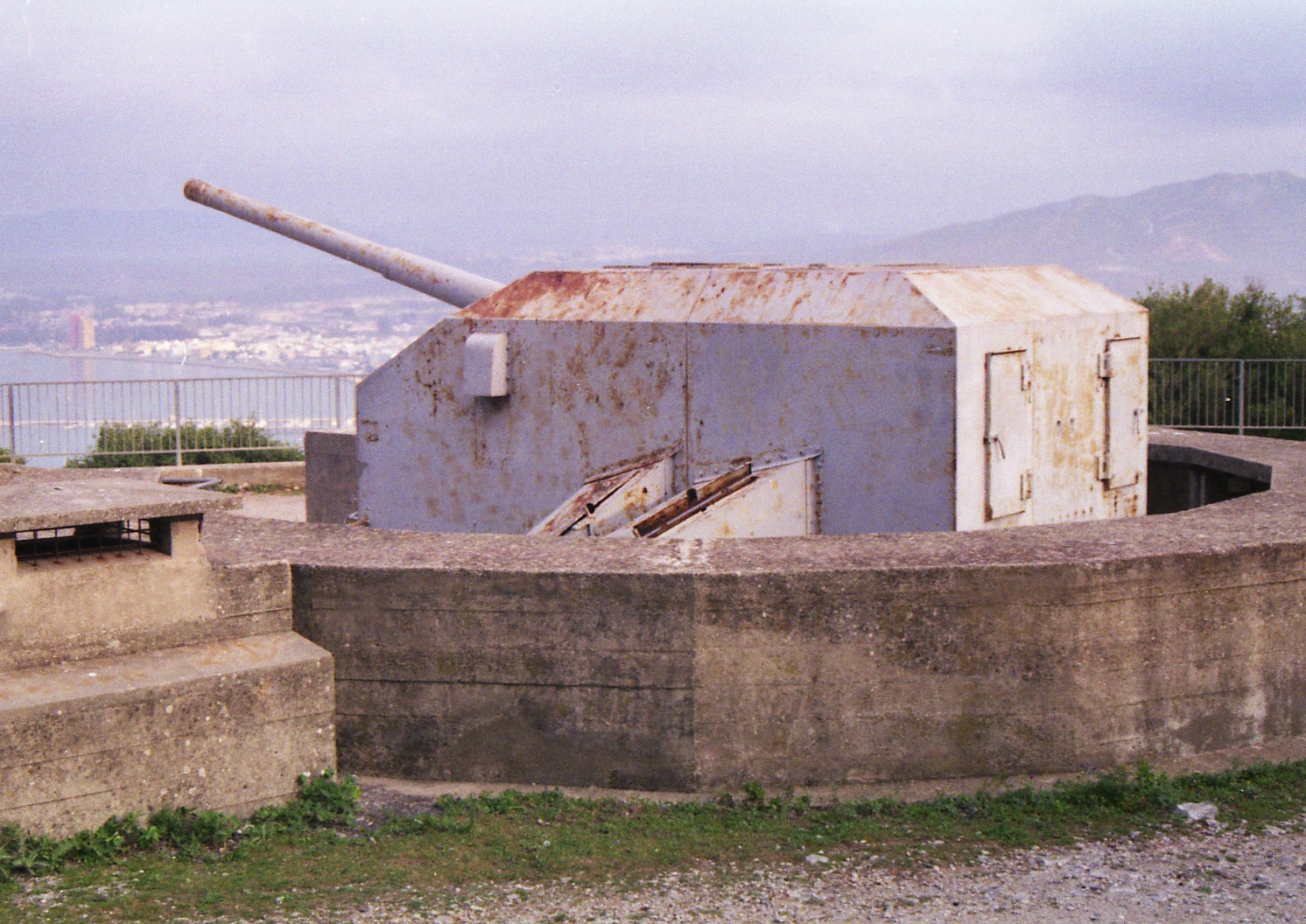
Fortifications of Gibraltar
The Gibraltar peninsula, located at the far southern end of Iberia, has great strategic importance as a result of its position by the Strait of Gibraltar where the Mediterranean Sea meets the Atlantic Ocean. It has repeatedly been contested between European and North African powers and has endured fourteen sieges since it was first settled in the 11th century. The peninsula's occupants – Moors, Spanish, and British – have built successive layers of fortifications and defences including walls, bastions, casemates, gun batteries, magazines, tunnels and galleries. At their peak in 1865, the fortifications housed around 681 guns mounted in 110 batteries and positions, guarding all land and sea approaches to Gibraltar. The fortifications continued to be in military use until as late as the 1970s and by the time tunnelling ceased in the late 1960s, over 34 miles (55 km) of galleries had been dug in an area of only 2.6 square miles (6.7 km2).
Gibraltar's fortifications are clustered in three main areas. The densest fortifications are in the area where historically Gibraltar was under the most threat – at the north end of the peninsula, the North Front, facing the isthmus with Spain. Another group of fortifications guards the town and the harbour, referred to as the West Side. The southern end of the town is guarded by the South Land Front. Few fortifications exist on the east side, as the sheer cliff of the Rock of Gibraltar is a virtually impassable obstacle. Further fortifications occupy the plateaus of Windmill Hill and Europa Point at the southern end of the peninsula. Lookout posts and batteries on the summits of the Rock provide a 360° view across the Strait and far into Spain. Although Gibraltar is now largely demilitarised, many of the fortifications are still intact and some, such as the Great Siege Tunnels and the Charles V Wall – where many of Gibraltar's population of Barbary macaques live – have become tourist attractions.
The nature and position of Gibraltar's defences have been dictated by the territory's topography. It is a long, narrow peninsula measuring 5.1 kilometres (3.2 miles) by 1.6 kilometres (1 mile) wide at maximum, with a land area of about six square kilometres (2.3 square miles). The only land access to the peninsula is via a sandy isthmus, only three metres (9.8 feet) above sea level, most of which is now occupied by the Spanish town of La Línea de la Concepción. The peninsula is dominated by the limestone massif of the Rock of Gibraltar, which presents a sheer cliff over 400 metres (1,300 feet) high at its north end, facing the isthmus. The Rock extends southwards for 2.5 kilometres (1.6 miles) with several peaks before it descends to two southern plateaus at heights of between 90–130 metres (300–430 feet) and 30–40 metres (98–131 feet) above sea level. The southern tip of Gibraltar is surrounded by steep cliffs. The Rock itself is asymmetric, with a moderate slope on the west side and a very steep (and in places near-vertical) slope on the east side. The original core of the town of Gibraltar occupies the lower north-west side of the Rock, adjoining the Bay of Gibraltar, though it has grown considerably to the point that the built-up area now stretches all the way to Europa Point on the southern tip of the peninsula. A great deal of 20th century land reclamation on the west side has also widened the coastal area, which was formerly quite narrow. A couple of small settlements, originally fishing villages, occupy the east side.
These features have made Gibraltar a naturally strong defensive position. The isthmus lacks any natural cover, exposing any approaching enemy to opposing fire. The heights of the Rock form a natural barrier to movement and rocky ledges provide natural platforms for gun batteries. The sheer cliffs on the north and east sides of the Rock block access from those directions and the sea cliffs around the southern end of the peninsula make landings there difficult, especially if opposed. A single road connects Gibraltar with Spain, and within the territory most roads are narrow and often steep due to the restricted land area. Over the centuries, Gibraltar's successive occupants have built an increasingly complex set of fortifications around, on top of and incorporating the territory's natural features.
Writing in 1610, the Spanish historian Fernando del Portillo commented that Gibraltar was "a stronghold from its very topography which with a little art could be made impregnable," and so it has proved. The Irish writer George Newenham Wright observed in 1840 that "the surface of the Rock is wholly occupied by defensive works; where it was possible, and often where it appeared almost impracticable, batteries and fortifications have been formed. From Europa Point, which pushes into the sea on the south side, to the highest point of the Rock, there is not a single point that has not been put into a defensible condition . . . Proceeding towards Europa Point, at the entrance of the town, fortifications, magazines, barracks, and batteries are placed wherever the nature of the surface would permit."
Gibraltar's fortifications have evolved in a number of stages. Its first permanent inhabitants, the Moors of North Africa, are said to have established a fort on Djebel Tarik (the Mount of Tarik, a name that was eventually corrupted into Gibraltar) "to be on guard and watch events on the other side of the Straits" as early as 1068. Gibraltar was fortified for the first time in 1160 by the Almohad Sultan Abd al-Mu'min in response to the coastal threat posed by the Christian kings of Aragon and Castile. The Rock of Gibraltar was renamed Jebel al-Fath (the Mount of Victory), though this name did not persist, and a fortified town named Medinat al-Fath (the City of Victory) was laid out on the upper slopes of the Rock. It is unclear how much of Medinat al-Fath was actually built, as the surviving archaeological remains of Moorish Gibraltar are scanty. A portion of wall some 500 metres (1,600 ft) long still survives to the south of the main part of the city of Gibraltar, of similar design to defensive walls in Morocco. It may have protected a settlement on the upper part of the Rock, around where the modern Queen's Road is, but firm archaeological evidence is lacking.
The city fell to the Castilians in 1309 after the first siege of Gibraltar and its fortifications were repaired and improved by King Ferdinand IV of Castile, who ordered the construction of a keep above the town. The Castilians maintained control of Gibraltar until 1333, resisting a Moorish siege in 1315, but relinquished it in 1333 after the third siege of Gibraltar. After defeating a Castilian counter-siege which ended after two months, the Marinid sultan Abu al-Hasan Ali ibn Othman ordered a refortification of Gibraltar "with strong walls as a halo surrounds the crescent moon". Many details of the rebuilt city are known due to the work of Abu al-Hasan's biographer, Ibn Marzuq, whose Musnad (written around 1370–71) describes the reconstruction of Gibraltar. The city was expanded, and a new defensive wall was built to cover the western and southern flanks, with towers and connecting passages added to strengthen them. The existing fortifications were also strengthened and repaired. The weak points that the Castilians had exploited were improved.
The refortified city occupied the north-eastern part of the present-day city, reaching from the area of Grand Casemates Square up to Upper Castle Road. It was divided into three main quarters which functioned as a series of baileys through which troops could fall back in stages. The Tower of Homage (now usually called the Moorish Castle, though more properly that name refers to the entire fortified area of the Moorish city) was located at the highest point, serving as a final redoubt. The Tower was a formidable square keep situated within a kasbah and had the largest footprint of all the towers to be built in Moorish Al-Andalus (320 square metres (3,400 sq ft)). It was a much-strengthened rebuilding of an earlier tower and still bears scars on its eastern wall from projectiles shot by the Castilians during the siege of 1333. The kasbah could only be accessed via a single gate, which still survives; an inscription visible up to the 18th century recorded that it had been dedicated to Yusuf I, Sultan of Granada.
Recent media
Recent media