
Recent from talks
Geography of Afghanistan
Knowledge base stats:
Talk channels stats:
Members stats:
Geography of Afghanistan
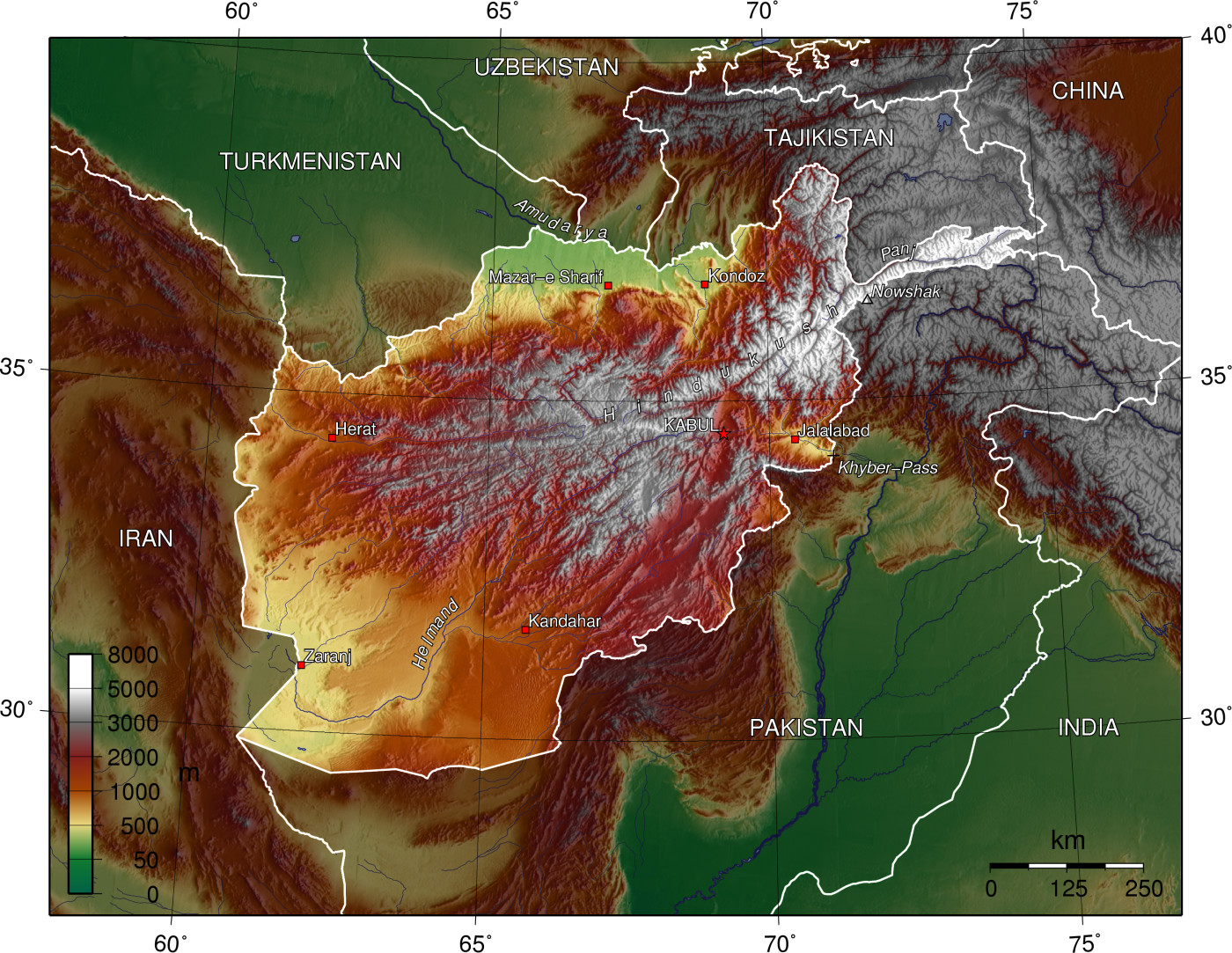
Afghanistan is a landlocked mountainous country located on the Iranian Plateau, at the crossroads of Central Asia and South Asia. The country is the 40th largest in the world in size. Kabul is the capital and largest city of Afghanistan, located in the Kabul Province. With a location at the intersection of major trade routes, Afghanistan has attracted a succession of invaders since the sixth century BC.
Afghanistan contains most of the Hindu Kush. There are a number of major rivers in the country, including Amu Darya, Arghandab, Farah, Hari, Helmand, Kabul, Kokcha, and Kunar. The country also possesses many smaller rivers as well as streams, canals, lakes, ponds, and springs. Most of its fresh water historically flowed into neighboring countries.
The Hindu Kush mountain range reaches a height of 7,492 m (24,580 ft) at Noshaq, Afghanistan's highest peak. Of the ranges extending southwestward from the Hindu Kush, the Foladi peak (Shah Foladi) of the Baba mountain range (Koh-i-Baba) reaches the greatest height: 5,142 m (16,870 ft). The Safed Koh range, which includes the Tora Bora area, dominates the border area southeast of Kabul.
Important passes include the Unai Pass across the Safed Koh, the Kushan and Salang Passes through the Hindu Kush, and the Khyber Pass that connects Afghanistan with Pakistan. The summit of the Khyber Pass at 1,070 m (3,510 ft) at Landi Kotal, Pakistan is 5 km (3 mi) east of the border town of Torkham. Other key passages through the mountainous Pakistan border include two from Paktika Province into Pakistan's Waziristan region: one at Angoor Ada, and one further south at the Gumal River crossing, plus the Charkai River passage south of Khost, Afghanistan, at Pakistan's Ghulam Khan village into North Waziristan. The busy Pak-Afghan border crossing at Wesh, Afghanistan is in a flat and dry area, though this route involves Pakistan's Khojak Pass at 2,707 m (8,881 ft) just 14 km (9 mi) from the border. The border connects Kandahar and Spin Boldak in Afghanistan with Quetta in Pakistan.
The Wakhan Corridor in the northeast lies eastward of the province of Panjshir, between the Hindu Kush and the Pamir Mountains, which leads to the Wakhjir Pass into Xinjiang in China. In Kabul, and over all the northern part of the country to the descent at Gandamak, winter is rigorous, especially so on the high Arachosian plateau.
Although Herat is approximately 240 m (787 ft) lower than Kandahar, the summer climate there is more temperate along with the yearly climate. From May to September, the wind blows from the northwest with great force, and this extends across the country to Kandahar. The winter is mild; snow melts as it falls, and even on the mountains does not lie long. Three years out of four at Herat it does not freeze hard enough for the people to store ice. Yet, it was not very far from Herat, in Rafir Kala, in 1750, where Ahmad Shah's army, retreating from Persia, is said to have lost 18,000 men from cold in a single night. In the northern Herat districts records of the coldest month (February) show the mean minimum as −8 °C (18 °F) and the maximum as 3 °C (37 °F). The eastern reaches of the Hari River, including the rapids, are frozen hard in the winter, and people travel on it as on a road.
Rainfall in Afghanistan is very scarce, and mainly only affects the northern highlands, arriving in March and April. Rainfall in the more arid lowlands is rare, and can be very unpredictable. Marked characteristics are the great differences of summer and winter temperature and of day and night temperature, as well as the extent to which change of climate can be attained by slight change of place. The Afghan climate is a dry one. The sun shines for three-fourths of the year, and the nights are clearer than the days.
Taking the highlands of the country as a whole, there is no great difference between the mean temperature of Afghanistan and that of the lower Himalaya. However, a remarkable feature of the Afghan climate is its extreme temperature range within limited periods. The smallest daily range in the north is when the weather is cold; the greatest is when it is hot. For seven months of the year (from May to November) this range exceeds 17 °C (31 °F) daily. Waves of intense cold occur, lasting for several days, and one may have to endure temperatures of −24 °C (−11 °F), rising to a maximum of −8 °C (18 °F). At Ghazni the snow has been known to stay long beyond the vernal equinox; the temperatures sink as low as −25 °C (−13 °F). Oral tradition tells of the destruction of the entire population of Ghazni by snowstorms on more than one occasion.[citation needed] On the other hand, the summer temperature is exceedingly high, especially in the Oxus regions, where a shade maximum of 45–50 °C (113–122 °F) is not uncommon.
Hub AI
Geography of Afghanistan AI simulator
(@Geography of Afghanistan_simulator)
Geography of Afghanistan
Afghanistan is a landlocked mountainous country located on the Iranian Plateau, at the crossroads of Central Asia and South Asia. The country is the 40th largest in the world in size. Kabul is the capital and largest city of Afghanistan, located in the Kabul Province. With a location at the intersection of major trade routes, Afghanistan has attracted a succession of invaders since the sixth century BC.
Afghanistan contains most of the Hindu Kush. There are a number of major rivers in the country, including Amu Darya, Arghandab, Farah, Hari, Helmand, Kabul, Kokcha, and Kunar. The country also possesses many smaller rivers as well as streams, canals, lakes, ponds, and springs. Most of its fresh water historically flowed into neighboring countries.
The Hindu Kush mountain range reaches a height of 7,492 m (24,580 ft) at Noshaq, Afghanistan's highest peak. Of the ranges extending southwestward from the Hindu Kush, the Foladi peak (Shah Foladi) of the Baba mountain range (Koh-i-Baba) reaches the greatest height: 5,142 m (16,870 ft). The Safed Koh range, which includes the Tora Bora area, dominates the border area southeast of Kabul.
Important passes include the Unai Pass across the Safed Koh, the Kushan and Salang Passes through the Hindu Kush, and the Khyber Pass that connects Afghanistan with Pakistan. The summit of the Khyber Pass at 1,070 m (3,510 ft) at Landi Kotal, Pakistan is 5 km (3 mi) east of the border town of Torkham. Other key passages through the mountainous Pakistan border include two from Paktika Province into Pakistan's Waziristan region: one at Angoor Ada, and one further south at the Gumal River crossing, plus the Charkai River passage south of Khost, Afghanistan, at Pakistan's Ghulam Khan village into North Waziristan. The busy Pak-Afghan border crossing at Wesh, Afghanistan is in a flat and dry area, though this route involves Pakistan's Khojak Pass at 2,707 m (8,881 ft) just 14 km (9 mi) from the border. The border connects Kandahar and Spin Boldak in Afghanistan with Quetta in Pakistan.
The Wakhan Corridor in the northeast lies eastward of the province of Panjshir, between the Hindu Kush and the Pamir Mountains, which leads to the Wakhjir Pass into Xinjiang in China. In Kabul, and over all the northern part of the country to the descent at Gandamak, winter is rigorous, especially so on the high Arachosian plateau.
Although Herat is approximately 240 m (787 ft) lower than Kandahar, the summer climate there is more temperate along with the yearly climate. From May to September, the wind blows from the northwest with great force, and this extends across the country to Kandahar. The winter is mild; snow melts as it falls, and even on the mountains does not lie long. Three years out of four at Herat it does not freeze hard enough for the people to store ice. Yet, it was not very far from Herat, in Rafir Kala, in 1750, where Ahmad Shah's army, retreating from Persia, is said to have lost 18,000 men from cold in a single night. In the northern Herat districts records of the coldest month (February) show the mean minimum as −8 °C (18 °F) and the maximum as 3 °C (37 °F). The eastern reaches of the Hari River, including the rapids, are frozen hard in the winter, and people travel on it as on a road.
Rainfall in Afghanistan is very scarce, and mainly only affects the northern highlands, arriving in March and April. Rainfall in the more arid lowlands is rare, and can be very unpredictable. Marked characteristics are the great differences of summer and winter temperature and of day and night temperature, as well as the extent to which change of climate can be attained by slight change of place. The Afghan climate is a dry one. The sun shines for three-fourths of the year, and the nights are clearer than the days.
Taking the highlands of the country as a whole, there is no great difference between the mean temperature of Afghanistan and that of the lower Himalaya. However, a remarkable feature of the Afghan climate is its extreme temperature range within limited periods. The smallest daily range in the north is when the weather is cold; the greatest is when it is hot. For seven months of the year (from May to November) this range exceeds 17 °C (31 °F) daily. Waves of intense cold occur, lasting for several days, and one may have to endure temperatures of −24 °C (−11 °F), rising to a maximum of −8 °C (18 °F). At Ghazni the snow has been known to stay long beyond the vernal equinox; the temperatures sink as low as −25 °C (−13 °F). Oral tradition tells of the destruction of the entire population of Ghazni by snowstorms on more than one occasion.[citation needed] On the other hand, the summer temperature is exceedingly high, especially in the Oxus regions, where a shade maximum of 45–50 °C (113–122 °F) is not uncommon.
Recent media