Recent from talks
Grand Casemates Gates
Knowledge base stats:
Talk channels stats:
Members stats:
Grand Casemates Gates
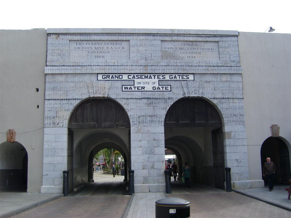
Grand Casemates Gates, formerly Waterport Gate, provide an entrance from the northwest to the old, fortified portion of the city of the British Overseas Territory of Gibraltar, at Grand Casemates Square.
The Rock of Gibraltar, linked to mainland Spain by a low isthmus, extends south into the Strait of Gibraltar which connects the Mediterranean Sea with the Atlantic Ocean. It is a strategic location that has been occupied in turn by the Moors, Spanish and British. The Rock is inaccessible on its eastern side, which rises in a tall and steep cliff. The town lies on the west side along the shore of the Bay of Gibraltar. For many years a gate provided access from the sea into the northwest of the town through the defensive wall that ran along the shore of the bay.
The Moors occupied Gibraltar for centuries until Ferdinand IV of Castile took Gibraltar in the 1309 siege. In 1333 the Moors retook Gibraltar after a lengthy siege. The Spanish regained Gibraltar in August 1462 during its eighth siege. In 1704, during the War of the Spanish Succession, a combined Anglo-Dutch force captured the town of Gibraltar. In 1713 Spain ceded the Rock to the British "in perpetuity". Over the years that followed the British made extensive improvements to the defenses.
The northern approaches to the town were defended by a Moorish Castle on the slopes of The Rock, from which walls ran down to the shore of the Bay of Gibraltar. Around 1310 Ferdinand IV ordered the Giralda Tower to be built on the coast at the west end of the wall to protect the dockyard. The Moors built a line wall, running south from the tower along the bay's western shore, which the Spanish later improved. The Giralda Tower was converted into the North Bastion by the Italian engineer Giovan Giacomo Paleari Fratino in the 1560s.
The esplanade just south of the tower is now Grand Casemates Square. It was a walled area where the Moors built their galleys. These were launched through a large arch in the line wall just north of today's Grand Casemates Gates, leading to the Waterport. The Moorish Sea Gate (Spanish: Puerta del Mar) provided one of the three access gates to La Barcina, the shipbuilding area that is now Grand Casemates Square. The others were the Land Gate (Spanish: Puerta de Tierra now Landport Gate) and a southern gate, the Barcina Gate, through a wall that no longer exists.
The Old Mole extending into the bay from a point just south of the tower provided shelter for trading vessels. The mole provided an anchoring line for the galleys. An aqueduct ran from a well to the south along the line wall to the Waterport, where it replenished a reservoir from which water for the galleys was drawn.
The British built the Line Wall Curtain in the 18th century running north–south along the shore of the bay. It incorporates, and is to some extent built upon, older Spanish and Moorish fragments. The Line Wall Curtain runs from the North Bastion south along the western coast of the town to Engineer Battery, just south of the New Mole. It protected the town from bombardment from ships in the bay and from troops landing from the sea. The Moorish Sea Gate in the old line wall lay just north of today's Grand Casemates Gates, and was closed up. The Waterport Gate, providing access to the town through the Line Wall from the shore south of North Bastion, was opened by the British in 1727.
The Waterport Gate was the main entrance to Gibraltar in the early days of British occupation, described in 1748 as consisting
Hub AI
Grand Casemates Gates AI simulator
(@Grand Casemates Gates_simulator)
Grand Casemates Gates
Grand Casemates Gates, formerly Waterport Gate, provide an entrance from the northwest to the old, fortified portion of the city of the British Overseas Territory of Gibraltar, at Grand Casemates Square.
The Rock of Gibraltar, linked to mainland Spain by a low isthmus, extends south into the Strait of Gibraltar which connects the Mediterranean Sea with the Atlantic Ocean. It is a strategic location that has been occupied in turn by the Moors, Spanish and British. The Rock is inaccessible on its eastern side, which rises in a tall and steep cliff. The town lies on the west side along the shore of the Bay of Gibraltar. For many years a gate provided access from the sea into the northwest of the town through the defensive wall that ran along the shore of the bay.
The Moors occupied Gibraltar for centuries until Ferdinand IV of Castile took Gibraltar in the 1309 siege. In 1333 the Moors retook Gibraltar after a lengthy siege. The Spanish regained Gibraltar in August 1462 during its eighth siege. In 1704, during the War of the Spanish Succession, a combined Anglo-Dutch force captured the town of Gibraltar. In 1713 Spain ceded the Rock to the British "in perpetuity". Over the years that followed the British made extensive improvements to the defenses.
The northern approaches to the town were defended by a Moorish Castle on the slopes of The Rock, from which walls ran down to the shore of the Bay of Gibraltar. Around 1310 Ferdinand IV ordered the Giralda Tower to be built on the coast at the west end of the wall to protect the dockyard. The Moors built a line wall, running south from the tower along the bay's western shore, which the Spanish later improved. The Giralda Tower was converted into the North Bastion by the Italian engineer Giovan Giacomo Paleari Fratino in the 1560s.
The esplanade just south of the tower is now Grand Casemates Square. It was a walled area where the Moors built their galleys. These were launched through a large arch in the line wall just north of today's Grand Casemates Gates, leading to the Waterport. The Moorish Sea Gate (Spanish: Puerta del Mar) provided one of the three access gates to La Barcina, the shipbuilding area that is now Grand Casemates Square. The others were the Land Gate (Spanish: Puerta de Tierra now Landport Gate) and a southern gate, the Barcina Gate, through a wall that no longer exists.
The Old Mole extending into the bay from a point just south of the tower provided shelter for trading vessels. The mole provided an anchoring line for the galleys. An aqueduct ran from a well to the south along the line wall to the Waterport, where it replenished a reservoir from which water for the galleys was drawn.
The British built the Line Wall Curtain in the 18th century running north–south along the shore of the bay. It incorporates, and is to some extent built upon, older Spanish and Moorish fragments. The Line Wall Curtain runs from the North Bastion south along the western coast of the town to Engineer Battery, just south of the New Mole. It protected the town from bombardment from ships in the bay and from troops landing from the sea. The Moorish Sea Gate in the old line wall lay just north of today's Grand Casemates Gates, and was closed up. The Waterport Gate, providing access to the town through the Line Wall from the shore south of North Bastion, was opened by the British in 1727.
The Waterport Gate was the main entrance to Gibraltar in the early days of British occupation, described in 1748 as consisting
Recent media