Recent from talks
Great Indian Warpath
Knowledge base stats:
Talk channels stats:
Members stats:
Great Indian Warpath
The Great Indian Warpath (GIW)—also known as the Great Indian War and Trading Path, or the Seneca Trail—was part of the network of trails in eastern North America developed and used by Native Americans which ran through the Great Appalachian Valley. The system of footpaths (the Warpath branched off in several places onto alternate routes and over time shifted westward in some regions) extended from what is now upper New York to deep within Alabama. Various Native peoples traded and made war along the trails, including the Catawba, numerous Algonquian tribes, the Cherokee, and the Iroquois Confederacy. The British traders' name for the route was derived from combining its name among the northeastern Algonquian tribes, Mishimayagat or "Great Trail", with that of the Shawnee and Delaware, Athawominee or "Path where they go armed".[citation needed]
The age of the Great Indian Warpath is unknown. Many of the trails were first broken by animals traveling to the salt licks in the region, especially by the herds of buffalo in the Valley of Virginia. These animal trails were later used by Native Americans. The trails were used for commerce, trading and communication between tribes before the land was explored by Europeans. In Virginia during November 1728, William Byrd II commented while passing a branch of the Indian trail what would later be called the Great Wagon Road in what would eventually be Henry County, Virginia, that "The Indians, who have no way of traveling except on the Hoof, make nothing of going 25 miles a day, and carrying their little Necessities at their backs, and Sometimes a Stout Pack of Skins into the bargain."
While archaeology shows that the Valley of Virginia was inhabited before the arrival of the Europeans, by the 18th century most of the region was abandoned. Only smaller villages and settlements of different tribes occupied the valley, which was used as a hunting ground, a travel route, and a warpath between the two great clusters of Eastern Indians in the 17th and 18th centuries.
In the north, the line of the Seneca Trail formed the boundary of "the frontier" by the time of the French and Indian War (1756–63). When King George III issued a proclamation in 1763 forbidding further settlement beyond the mountains and demanding the return of settlers who had already crossed the Alleghenies, a line was designated roughly following the Seneca Trail.
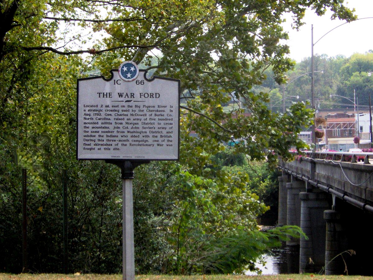
In the south, the GIW began at the Gulf of Mexico in the Mobile area and proceeded north by northeast, bisecting another trail known as the Upper Creek Path and crossing the Tennessee River near Guntersville. It then followed roughly the same route as the Tennessee upriver until reaching the vicinity of the modern Bridgeport. There it crossed the Tennessee once again at the Great Creek Crossing just below the foot of Long Island on the Tennessee, intersecting another path, the Cisca and St. Augustine Trail, which ran from the area of St. Augustine, Florida to that of Nashville, Tennessee.
Several miles upriver from Long Island, the GIW passed through the Nickajack area, so-called by the Cherokee (from Ani-Kusati) because it had once inhabited by the Koasati.[citation needed]
After following the south bank of the Tennessee River, the path proceeded through Running Water Valley to Lookout/Will's Valley, where it met the Cumberland Trail. From present-day Gadsden, Alabama, this trail passed through the latter valley at a point along the Upper Creek Path, on its way to the Cumberland Gap, the Ohio Valley, and the Great Lakes region. Having met, both trails crossed the foot of Lookout Mountain; their route was later followed by the improved Old Wauhatchie Pike.
Once over the mountain, the path crossed lower Chattanooga Valley to what archaeologists refer to as the Citico site. For several hundred years this was the pre-eminent town in the early period of the Mississippian culture in East Tennessee (until around 1200). Past Citico, the path ran east (later followed by the late Shallowford Road) to Missionary Ridge, where it divided. The main branch headed northeast toward the Shallow Ford (which can still be seen) across the Chickamauga River (South Chickamauga Creek) and the other branch went directly east (a route now followed by Bird's Mill/Brainerd Road) to cross at another ford at the site of the later Brainerd Mission and Bird's Mill.
Hub AI
Great Indian Warpath AI simulator
(@Great Indian Warpath_simulator)
Great Indian Warpath
The Great Indian Warpath (GIW)—also known as the Great Indian War and Trading Path, or the Seneca Trail—was part of the network of trails in eastern North America developed and used by Native Americans which ran through the Great Appalachian Valley. The system of footpaths (the Warpath branched off in several places onto alternate routes and over time shifted westward in some regions) extended from what is now upper New York to deep within Alabama. Various Native peoples traded and made war along the trails, including the Catawba, numerous Algonquian tribes, the Cherokee, and the Iroquois Confederacy. The British traders' name for the route was derived from combining its name among the northeastern Algonquian tribes, Mishimayagat or "Great Trail", with that of the Shawnee and Delaware, Athawominee or "Path where they go armed".[citation needed]
The age of the Great Indian Warpath is unknown. Many of the trails were first broken by animals traveling to the salt licks in the region, especially by the herds of buffalo in the Valley of Virginia. These animal trails were later used by Native Americans. The trails were used for commerce, trading and communication between tribes before the land was explored by Europeans. In Virginia during November 1728, William Byrd II commented while passing a branch of the Indian trail what would later be called the Great Wagon Road in what would eventually be Henry County, Virginia, that "The Indians, who have no way of traveling except on the Hoof, make nothing of going 25 miles a day, and carrying their little Necessities at their backs, and Sometimes a Stout Pack of Skins into the bargain."
While archaeology shows that the Valley of Virginia was inhabited before the arrival of the Europeans, by the 18th century most of the region was abandoned. Only smaller villages and settlements of different tribes occupied the valley, which was used as a hunting ground, a travel route, and a warpath between the two great clusters of Eastern Indians in the 17th and 18th centuries.
In the north, the line of the Seneca Trail formed the boundary of "the frontier" by the time of the French and Indian War (1756–63). When King George III issued a proclamation in 1763 forbidding further settlement beyond the mountains and demanding the return of settlers who had already crossed the Alleghenies, a line was designated roughly following the Seneca Trail.
In the south, the GIW began at the Gulf of Mexico in the Mobile area and proceeded north by northeast, bisecting another trail known as the Upper Creek Path and crossing the Tennessee River near Guntersville. It then followed roughly the same route as the Tennessee upriver until reaching the vicinity of the modern Bridgeport. There it crossed the Tennessee once again at the Great Creek Crossing just below the foot of Long Island on the Tennessee, intersecting another path, the Cisca and St. Augustine Trail, which ran from the area of St. Augustine, Florida to that of Nashville, Tennessee.
Several miles upriver from Long Island, the GIW passed through the Nickajack area, so-called by the Cherokee (from Ani-Kusati) because it had once inhabited by the Koasati.[citation needed]
After following the south bank of the Tennessee River, the path proceeded through Running Water Valley to Lookout/Will's Valley, where it met the Cumberland Trail. From present-day Gadsden, Alabama, this trail passed through the latter valley at a point along the Upper Creek Path, on its way to the Cumberland Gap, the Ohio Valley, and the Great Lakes region. Having met, both trails crossed the foot of Lookout Mountain; their route was later followed by the improved Old Wauhatchie Pike.
Once over the mountain, the path crossed lower Chattanooga Valley to what archaeologists refer to as the Citico site. For several hundred years this was the pre-eminent town in the early period of the Mississippian culture in East Tennessee (until around 1200). Past Citico, the path ran east (later followed by the late Shallowford Road) to Missionary Ridge, where it divided. The main branch headed northeast toward the Shallow Ford (which can still be seen) across the Chickamauga River (South Chickamauga Creek) and the other branch went directly east (a route now followed by Bird's Mill/Brainerd Road) to cross at another ford at the site of the later Brainerd Mission and Bird's Mill.
Recent media