
Community hub
Recent from talks
Contribute something
Nothing was collected or created yet.
Greysouthen
View on WikipediaThis article needs additional citations for verification. (December 2009) |
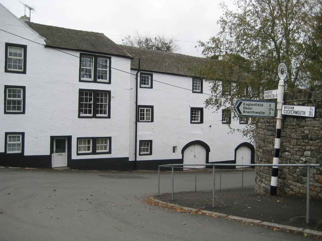
Greysouthen (/ˈɡreɪsuːn/ GRAY-soon) is a village and civil parish between the towns of Workington and Cockermouth, in the Cumberland district of Cumbria, North West England. It lies a couple of miles outside the boundary of the Lake District National Park. The village has an historic association with coal mining.
Key Information


History
[edit]In 1870, Greysouthen was described as a settlement of 136 houses, with an agricultural implement factory, a Quakers' chapel, a Wesleyan chapel and a flax mill.[2] In 1901 Greysouthen civil parish had an area of 1,558 acres.[3]
Mining
[edit]There is evidence of settlers digging for coal across west Cumbria as early as the 13th century.[4] Coal mining began in the Greysouthen area in the late 16th century.[5]
A majority stake in Greysouthen's coal lease was sold to William Walker & Company in 1787. The business remained profitable for the next 80 years. Another firm[which?] entered Greysouthen's coal extraction industry in 1800. Wilson & Company invested in another colliery within Greysouthen.[citation needed] The two collieries distributed coal tokens which represented the success of the mines. Between these two mines a feud broke out over mine space. Wilson & Co was fined £16,000 damages over illegally mining William Walker & Company's land.
By the start of the 19th century Greysouthen's thriving mining industry had become the sole employer. To house miners, small rows of cottages were built within the town. In 1823 Joseph Birbeck and J.W. Flecter began mining in Greysouthen. A tax value of £20 was introduced for the annual lease of 400 tons of coal. For every ton mined over this, an additional tax of 1 shilling was applied.[6]
The Melgramfitz pit was closed in 1886, which led to the end of the Greysouthen as a coal mining community.[3]
Greysouthen's 19th century miners were known for their ale consumption, which magistrates felt was their prime concern.[7]
Governance
[edit]
There are two tiers of local government covering Greysouthen, at parish and unitary authority level: Greysouthen Parish Council and Cumberland Council. The parish council meets at Greysouthen Village Hall on The Went.[8]
For national elections, Greysouthen forms part of the Whitehaven and Workington constituency.[9]
Administrative history
[edit]Greysouthen was historically a township in the ancient parish of Brigham, which formed part of the historic county of Cumberland.[10][11] The township of Greysouthen took on civil functions under the poor laws from the 17th century onwards. As such, the township also became a civil parish in 1866, when the legal definition of 'parish' was changed to be the areas used for administering the poor laws.[12]
When elected parish and district councils were established in 1894, Greysouthen was included in the Cockermouth Rural District.[11] Cockermouth Rural District was abolished in 1974, becoming part of the borough of Allerdale in the new county of Cumbria.[13][14] Allerdale was in turn abolished in 2023 when the new Cumberland Council was created, also taking over the functions of the abolished Cumbria County Council in the area.[15]
Community
[edit]Greysouthen is surrounded by farmland through which two streams run. The village is divided into two by the local residents – "up the went" and "down the went". The 'went' is a hill at the centre of Greysouthen.[citation needed]
St Josephs Roman Catholic Church is approximately 3 miles (5 km) from the centre of the village. Greysouthen has one large playing field with an adventure playground, football pitch, and a garden commemorating the Queen's Silver Jubilee.[citation needed]
Greysouthen had previously received a bus service, which stopped about ten times daily with connections to Workington and Cockermouth. The service was subsidised by the county council and operated by minor bus companies. It ended in 2015.
The village is in the catchment area for Paddle Primary Academy, a Church of England institution, in the neighbouring village of Eaglesfield, and is also in catchment for Cockermouth School and Keswick School, Cockermouth being nearer.
The parish council has been supporting Cumbrian rural communities over the introduction of superfast broadband and mobile coverage. Superfast broadband was activated in the village in January 2015. [citation needed]
Ecology
[edit]There are 7 beaches within 10 miles (16 km) of Greysouthen, Siddick is the closest at about 5 miles (8 km); the second closest is Maryport then Workington, Crosscanonby, Allonby, Parton and Whitehaven.
The Greysouthen area supports a variety of bird species including northern lapwings, common snipes, Eurasian curlews, common woodpigeons, buzzards, Eurasian oystercatchers, common pheasants, Eurasian sparrowhawks, and quail. Red squirrels are also found. Orange tips, red admirals, and painted lady butterflies occur within the area.[16]
Locally growing west Cumbrian wild plants include the greater butterfly orchid, early purple orchid and yellow rattle.[citation needed]
Population
[edit]
|
|
|
| ||||||||||||||||||||||||||||||||||||
| Source: [17] | |||||||||||||||||||||||||||||||||||||||
The population of Greysouthen between 1880 and 1900 fell by about 210 people in a 20-year period, this a period after the closure of the local mines.
See also
[edit]References
[edit]- ^ "2021 Census Parish Profiles". NOMIS. Office for National Statistics. Retrieved 31 March 2025. (To get individual community data, use the query function on table PP002.)
- ^ "Greysouthen". A Vision of Britain through Time. GB Historical GIS / University of Portsmouth. Retrieved 20 April 2025.
- ^ a b "The Flectchers". Bulmer's History & Directory Of Cumberland, 1901. Retrieved 2 May 2013.
- ^ "Visit Cumbria". VisitCumbria. Retrieved 2 May 2013.
- ^ "Cumbria's Past History" (PDF). Cumbria past. Retrieved 2 May 2013.[page needed]
- ^ "Cumbria mining history explained". Printed by T. Wilson and sons. 1877. Retrieved 2 May 2013.[page needed]
- ^ "Greysouthen", Visitoruk.com
- ^ "Greysouthen Parish Council". Retrieved 20 April 2025.
- ^ "Election Maps". Ordnance Survey. Retrieved 20 April 2025.
- ^ Whellan, William (1860). The History and Topography of the Counties of Cumberland and Westmorland. p. 295. Retrieved 13 April 2025.
- ^ a b "Greysouthen Township / Civil Parish". A Vision of Britain through Time. GB Historical GIS / University of Portsmouth. Retrieved 20 April 2025.
- ^ Youngs, Frederic (1991). Guide to the Local Administrative Units of England: Volume II, Northern England. London: Royal Historical Society. p. xv. ISBN 0861931270.
- ^ "The English Non-metropolitan Districts (Definition) Order 1972", legislation.gov.uk, The National Archives, SI 1972/2039, retrieved 3 March 2023
- ^ "The English Non-metropolitan Districts (Names) Order 1973", legislation.gov.uk, The National Archives, SI 1973/551, retrieved 3 March 2023
- ^ "The Cumbria (Structural Changes) Order 2022", legislation.gov.uk, The National Archives, SI 2022/331, retrieved 24 January 2024
- ^ "Villages in Cumbria". The Cumbria Directory (via Wayback Mashine). Archived from the original on 5 August 2009. Retrieved 5 August 2009.
- ^ "Greysouthen Tn/CP" A Vision of Britain through Time
External links
[edit]- Cumbria County History Trust: Greysouthen (nb: provisional research only - see Talk page)
![]() Media related to Greysouthen at Wikimedia Commons
Media related to Greysouthen at Wikimedia Commons
Greysouthen
View on GrokipediaGeography and Etymology
Location and Boundaries
Greysouthen is a civil parish situated between the towns of Workington and Cockermouth in the Cumberland district of Cumbria, North West England.[1] It lies approximately 3.5 miles west-south-west of Cockermouth, near the River Derwent and the historic Cockermouth and Workington railway line.[5] The parish encompasses an area of 1,646 acres (666 hectares), including about 500 acres of common moorland.[1] This territory covers the village of Greysouthen itself along with outlying areas such as Nepgill, Millbanks Court, Marron Lane, and Hardeygate at Bridgefoot.[6] Historically, Greysouthen formed a township within the ancient parish of Brigham, with its boundaries defined accordingly in the Allerdale above Derwent ward of Cumberland.[1] These boundaries reflect its position as a distinct administrative unit while sharing ecclesiastical and local governance ties with the broader Brigham parish structure.[5]Topography and Settlement Pattern
Greysouthen occupies a rural setting in the lowland landscapes of Cumbria, proximate to the Lake District National Park, characterized by gently rolling terrain conducive to pastoral agriculture. The village's physical landscape features a central shallow hill known as The Went, which rises modestly to around 75 meters and divides the settlement into two distinct parts: "up the went" on the higher ground to the north and "down the went" on the lower slopes to the south. This topographic division influences local perceptions of the village's internal structure, with housing and paths radiating from the hill's base.[7][8] The surrounding countryside consists primarily of undulating farmland, with slowly permeable, seasonally wet clayey and loamy soils that support mixed pastoral and arable farming practices typical of Cumbria's lowland character type. These soil conditions, combined with the area's average elevation of approximately 80 meters above sea level, facilitate drainage and cultivation of grasses and crops suited to the temperate climate. The village itself remains a compact rural settlement, historically comprising 136 houses as recorded in the late 19th century, reflecting its agrarian roots.[9][10][5] Modern extensions have integrated into this pattern, including Millbanks Court, a residential development within the parish that extends the built environment along the lower ground near Nepgill without altering the core rural topography. The area's accessibility to coastal features is notable, with seven beaches within 10 miles, the nearest being Siddick at about 5 miles to the west, providing a contrast to the inland farmland. This blend of hill, vale, and proximate shores underscores Greysouthen's position as a cohesive, low-density village enveloped by productive agricultural land.[3][7]Name Origin
The name Greysouthen derives from "Suthan's cliff" or "Suthán's rock/cliff," formed by combining the Primitive Welsh element creig, meaning "rock" or "cliff," with the personal name Suthan, which is of uncertain origin but possibly Celtic or Norse.[11] This etymology reflects the linguistic influences of early Celtic-speaking Britons and subsequent Norse settlers in the region of Cumbria, where such hybrid formations are common in place names.[11] Historical records show variations in spelling that trace the name's evolution, including Creiksothen around 1231, Craysothen in 1292 and 1307, Graysothen in 1299, and Graysone in 1505, indicating shifts from earlier forms emphasizing the rocky feature and personal association to more anglicized versions over time.[12] These changes align with broader patterns in Cumberland place names, where Old English, Celtic, and Norse elements blended amid medieval documentation practices.[12] The modern pronunciation is "Grey-soon," a simplification that diverges from the written form and highlights local phonetic traditions in Cumbria.[13] Additionally, the surname Grayson may originate as a habitational name from Greysouthen, particularly linked to the 1505 spelling Graysone, denoting individuals from the village.[14]History
Early Development
Greysouthen originated as a historical township within the ancient parish of Brigham in the county of Cumberland, now part of Cumbria, England. It was one of the Five Towns comprising the honour of Cockermouth, a feudal barony that included lowland settlements and the forest of Derwentfells.[1][15] By the 16th century, landownership in Greysouthen had become divided among several free tenants, reflecting a pattern of fragmented holdings typical of the region's medieval manorial structure. The early economy centered on agriculture, with farming as the primary occupation supporting the rural community through arable and pastoral activities on its 1,646 acres, including common moorland.[1] Religious life in the township developed with the establishment of nonconformist chapels in the 18th and 19th centuries. A Quaker meeting house was built in 1742 and operated until 1871, while a Wesleyan Methodist chapel opened in 1833, serving the growing population until its closure in the late 20th century. These institutions provided spiritual and social hubs amid the predominantly agrarian setting.[1][5] Greysouthen assumed civil functions for poor law administration from the 17th century onward and was formally constituted as a civil parish in 1866 under the Poor Law Amendment Act, which recognized townships as independent administrative units. This period also marked the initial stirrings of coal mining activity in the late 16th century, setting the stage for later industrial shifts.[16][7]Mining and Industrial Era
Coal mining in Greysouthen commenced in the early 18th century, with records indicating activity by the 1720s, building upon the area's prior agricultural foundation.[1] The Cooksons of Newcastle operated coal workings in the township before 1750, followed by Sir James Lowther's involvement in 1761.[17] A significant expansion occurred in 1787 when William Walker & Company acquired a majority stake in the local coal lease, operating profitably for the subsequent 80 years and driving economic growth through extensive trade.[17] In 1800, Wilson & Company entered the field by opening a new colliery, with J.W. Fletcher as a partner, intensifying competition and sparking a feud over underground mine space.[17] The dispute escalated when Walker & Company was accused of illegally mining on Wilson & Company's land and damaging their workings by diverting water, resulting in a £16,000 damages award against Walker & Company at the 1807 Carlisle Assize.[17] By the mid-19th century, five collieries were active, contributing to a population peak of 758 in 1861 as mining attracted workers and their families to the area.[1] The industrial era also fostered related enterprises, including a steam-powered flax mill at Oldfield where linen thread was manufactured in the early to mid-19th century, and a sickle manufactory supporting local agriculture.[1][7] Operations declined in the 1880s due to depleting seams, culminating in the closure of the Melgramfitz Pit in 1886 after it had been sunk in 1863 to work the Ten Quarters, Cannel, and Metal Band seams; this marked the end of Greysouthen's mining community and led to a sharp population drop from 690 in 1881 to 490 in 1901.[1][17][18]Governance and Administration
Current Local Government
Greysouthen operates under a two-tier local government system, with the Greysouthen Parish Council serving as the lowest tier to address community-specific matters such as village hall management and compliance with data protection regulations like GDPR.[3] The upper tier is provided by Cumberland Council, a unitary authority established in April 2023 that handles broader services including planning, waste management, and social care across the region.[19] In October 2025, the creation of the Cumbria Combined Authority was approved; it is scheduled to be established in early 2026 to oversee strategic areas such as transport, skills, housing, and economic growth, while Cumberland Council retains responsibility for most local services.[20] The Greysouthen Parish Council consists of nine elected members and is responsible for local issues within the parish, which includes the village and surrounding areas like Nepgill, Millbanks Court, Marron Lane, and Hardeygate at Bridgefoot. As of the latest register, there are 456 registered electors in the parish. The council holds monthly meetings at 7:15 p.m. in the Greysouthen Village Hall, excluding August and December, with the annual meeting occurring in May at 7:00 p.m. The clerk to the council is Susan Stuart, contactable at [email protected] or 07557 340580.[3][21] For financial transparency, the parish council reports all items of expenditure exceeding £100 in its meeting minutes, which are publicly available on its website.[3] At the national level, Greysouthen falls within the Whitehaven and Workington parliamentary constituency, represented in the UK House of Commons. The parish's historical administrative roots trace back to its origins within Brigham parish.[22]Historical Administrative Evolution
Greysouthen originated as a township within the ancient parish of Brigham in the historic county of Cumberland, encompassing approximately 1,646 acres of land that included common moorland.[1] This status reflected its early role as a subordinate administrative division under the broader ecclesiastical and civil oversight of Brigham, with landownership fragmented among multiple free tenants by the 16th century.[1] The township began assuming distinct civil functions, particularly for poor law administration, from the 17th century onward, culminating in its formal establishment as a separate civil parish in 1866 under reforms that separated civil from ecclesiastical responsibilities. From 1894 to 1974, Greysouthen fell within the Cockermouth Rural District, created by the Local Government Act 1894 to manage rural affairs outside urban areas.[23] In 1974, under the Local Government Act 1972, significant restructuring integrated Greysouthen into the newly formed Allerdale district council while placing it under the non-metropolitan county of Cumbria, which combined the former counties of Cumberland, Westmorland, and parts of Lancashire and Yorkshire. This arrangement persisted until April 1, 2023, when Allerdale was abolished as part of a broader devolution of powers, transferring administrative responsibilities to the Cumberland unitary authority.[24] The change aimed to streamline local governance by merging Allerdale with Carlisle and Copeland districts into a single entity responsible for the former Cumberland area.[25]Economy
Historical Economic Activities
Throughout its early history, Greysouthen's economy was primarily based on farming and agriculture, with the township encompassing 1,646 acres of land suitable for mixed farming practices.[1] The enclosure of 500 acres of common moor in 1826 further supported agricultural expansion, allowing for more efficient land use and tithe commutation under acts up to 1819.[1][7] In the 19th century, the local economy diversified beyond traditional farming with the establishment of industrial activities, including a steam-powered flax mill at Oldfield for linen-thread manufacture in the early to mid-1800s.[1][26] By 1870, an agricultural implement factory had also been established, contributing to the production of tools and machinery for local farmers.[7] Coal mining emerged as the dominant industry from the late 16th century, with records indicating operations by the 1720s and five collieries active by the mid-19th century; it became the primary employer, driving significant population growth to approximately 700 residents by 1880.[7][1] The sector's expansion included the sale of a major coal lease to William Walker & Company in 1787, which spurred further development and miner housing.[7] The closure of the Melgramfitz Pit in 1886 marked the end of large-scale mining, leading to economic decline as the industry waned; this resulted in a population drop of about 210 between 1880 and 1900, from 690 in 1881 to 490 in 1901, as employment opportunities diminished.[1][7]Modern Economic Profile
Greysouthen features a predominantly rural economy centered on agriculture and farming, reflecting the broader character of Cumbrian parishes. According to 2011 Census data analyzed by Action with Communities in Cumbria, approximately 3.8% of the economically active population (around 10 individuals) are employed in agriculture, underscoring its ongoing role despite the village's small scale.[27] This sector contributes to local food production and land management, with farms like Green Croft Farm operating as dairy enterprises in the area.[28] The village's proximity to the Lake District National Park bolsters tourism as an economic driver, attracting visitors to nearby attractions and supporting ancillary services such as accommodation and hospitality. This location also enables residential commuting to larger employment hubs like Workington and Cockermouth, with 2011 Census figures showing 28.3% of workers traveling 5-10 km to their jobs and 26.1% covering 10-20 km, often by car in an average of 7 minutes to the nearest employment center.[27] Overall, 6.7% of the workforce operates from home, highlighting a blend of local and regional economic ties.[27] Post the decline of mining, which once dominated local industry, Greysouthen has limited manufacturing and industrial activity, with employment shifting to services. The 2011 Census identifies health and social work as the largest sector at 16% (45 jobs), followed by education at 13% (40 jobs) and manufacturing at 12% (35 jobs).[27] The parish council provides small-scale community services, including support for events, grants to voluntary organizations, and maintenance of facilities like the village hall, fostering local economic resilience without large-scale operations.[29] The rollout of superfast broadband has notably influenced remote work opportunities, enabling digital connectivity in this rural setting. Local efforts through the Greysouthen Parish Broadband Campaign, including the appointment of a dedicated champion, advocated for infrastructure improvements that activated superfast access, aligning with Cumbria's wider push for rural digital enhancement.[30] This development supports self-employment (13.6% of workers) and home-based roles, with low unemployment at 1.3% Jobseeker's Allowance claimants as of 2013.[27]Demographics
Population Statistics
According to the 2021 United Kingdom census, the population of Greysouthen was 584 residents.[31] Historical census data reveal significant fluctuations in the village's population, largely tied to economic activity. The population rose from 455 in 1801 to a peak of 758 in 1861 during the local mining boom.[1] By 1881, it stood at 690, reflecting early signs of industrial decline.[1] The figure continued to fall, reaching 490 by 1901, and further declined to approximately 500 by 1961. In the 1870-72 period, census records noted 136 houses in Greysouthen, implying a population of around 600-700 people based on typical household sizes of the era.[5]| Census Year | Population |
|---|---|
| 1801 | 455 |
| 1861 | 758 |
| 1881 | 690 |
| 1901 | 490 |
| 1961 (approx.) | 500 |
| 2021 | 584 |