Community hub
Recent from talks
Knowledge base stats:
Talk channels stats:
Members stats:
Hudson Volcano
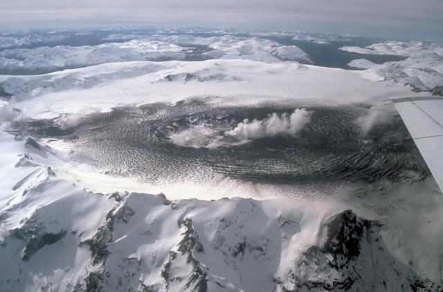
Hudson Volcano (Spanish: Volcán Hudson, Cerro Hudson, or Monte Hudson) is the most active volcano in the southern part of the Southern Volcanic Zone of the Andes Mountains in Chile, having erupted most recently in 2011. It was formed by the subduction of the oceanic Nazca Plate under the continental South American Plate. South of Hudson is a smaller volcano, followed by a long gap without active volcanoes, then the Austral Volcanic Zone. Hudson has the form of a 10-kilometre-wide (6-mile) caldera filled with ice; the Huemules Glacier emerges from the northwestern side of the caldera. The volcano has erupted rocks ranging from basalt to rhyolite, but large parts of the caldera are formed by non-volcanic rocks.
The volcano erupted numerous times in the late Pleistocene and Holocene, forming widespread tephra deposits both in the proximity of Hudson and in the wider region. Four large eruptions took place in 17,300–17,440 BP ("H0 eruption"), 7,750 BP ("H1 eruption"), 4,200 BP ("H2 eruption") and in 1991 AD ("H3 eruption"); the second is among the most intense volcanic eruptions in South America during the Holocene. A smaller eruption occurred in 1971. The 7,750 BP and 1991 eruptions had a substantial impact on the human population of Patagonia and (for the 7,750 BP eruption) Tierra del Fuego: The 7,750 BP eruption devastated the local ecosystem and may have caused substantial shifts in human settlement and lifestyle. During the 1991 eruption, volcanic ash covered a large area in Chile and neighbouring Argentina, causing high mortality in farm animals, aggravating an existing economic crisis, and reaching as far as Antarctica.
Hudson Volcano lies in the Andes of southern Chile, northwest of Lago Buenos Aires. The name "Hudson" refers to Francisco Hudson, a Chilean Navy captain and hydrographer. Another name of the volcano is Cerro de los Ventisqueros. Politically, Hudson Volcano is in the Aysen Province of Chile's Aysen Region. Most of the volcano is in the municipality of Aysen; the eastern and southern parts are in the municipalities of Coihaique and Rio Ibáñez, respectively. Owing to its remoteness and the dense vegetation at its foot, the volcano is poorly studied; it was recognized as a volcano only in 1970. The closest cities are Puerto Aysen 58 kilometres (36 mi) north-northeast and Coihaique 75 kilometres (47 mi) northeast; the Carretera Austral highway passes 30 kilometres (19 mi) from the volcano. The volcano can be accessed either from the sea along the Huemules River valley or by land via the valley of the Blanco River from Lago Elizalde-Lago Claro. Small populations, mostly farmers, live in the surrounding valleys.
The Andean Volcanic Belt includes four volcanic zones separated by gaps without recent volcanoes. From north to south they are the Northern Volcanic Zone, the Central Volcanic Zone, the Southern Volcanic Zone (SVZ) and the Austral Volcanic Zone (AVZ). Hudson is the second-southernmost volcano of the SVZ, after Rio Murta; erroneously, it is often referred to as the southernmost. Farther south there is the 350-kilometre-long (220 mi) Patagonian Volcanic Gap in the Andean Volcanic Belt, which separates Hudson from the Austral Volcanic Zone and its first volcano, Lautaro. The next volcanoes to the north are Mate Grande 35 kilometres (22 mi) and Macá and Cay 95 kilometres (59 mi) from Hudson, then Mentolat and the Puyuhuapi volcanic field.
The volcano is a 10-kilometre-wide (6 mi) ice-filled caldera that rises 1,000 to 1,200 metres (3,300 to 3,900 ft) above the surrounding terrain. Only the western and southern margins are well-defined. The highest point reaches 1,905 metres (6,250 ft) elevation. The edifice consists partly of volcanic rocks and partly of uplifted basement, and has an eroded appearance, with steep valleys cutting as much as 1 kilometre (0.6 mi) into the outer reaches of the volcano. The total volume of the volcano is about 147 cubic kilometres (35 cu mi), larger than other SVZ volcanoes, and it covers an area of about 300 square kilometres (120 sq mi). Cinder and spatter cones reach heights of 200 to 300 metres (660 to 980 ft) and are sources of lava flows outside of the caldera, especially in the Sorpresa Sur valley. There are two cones northeast of the caldera and one in the far southwest. The landscape of the Andes around Hudson is formed by numerous mountains (including the Cerros Hudson 12 kilometres (7.5 mi) south of the volcano) with deep, glacially carved valleys. Thick volcanic soils occur in the area.
The caldera is filled with about 2.5 cubic kilometres (0.6 cu mi) of 40-metre-thick (130 ft) ice, forming an ice surface at about 1,505 to 1,520 metres (4,940 to 4,990 ft) elevation. Ice flows out of the northwestern margin of the caldera and forms the Ventisquero de los Huemules Glacier. The Huemules Glacier is the largest glacier of Hudson Volcano, being 11 kilometres (6.8 mi) long, and the headwater of the Huemules River. The glacier is covered by tephra and its surface is at too low an altitude for the tephra to be buried under snow; thus from the air the glacier looks like a lava flow. A small crater lake is at its beginning and occupies a crater of the 1991 eruption. Most of the ice in the caldera was destroyed by the 1971 eruption, but by 1979 it had built up again. During the 1991 eruption, cones surrounded by crevasses and small lakes formed in the ice. The recovery of the ice after the 1991 eruption was slower, and by 2002 Huemules was retreating. During eruptions, pyroclastic material and lava can melt the ice. Other glaciers emanating from the ice cap are the Desplayado, Bayo, Ibáñez, El Frio, Sorpresa Sur and Sorpresa Norte glaciers. They were up to 3 kilometres (1.9 mi) long in 1974 but have retreated since then. Together with the Queulat Ice Cap, the Hudson glaciers make up a large part of the regional glacier inventory, and have left well-preserved moraines. The path of some of the glaciers may be influenced by local tectonic lineaments. Numerous rivers originate on Hudson; clockwise from north to south they include the Rio Desplayado to the north, the Rio Bayo to the east, the Rio Ibáñez, the Rio Sorpresa Sur, Rio Sorpresa Norte all to the southeast, and the Huemules River to the northwest. Numerous hot springs occur in the valleys, and produce creeks whose waters have peculiar smells and tastes. Volcanic activity might be responsible for fluctuations in the discharge of the Huemules River.
Off the western coast of South America, the Nazca Plate subducts beneath the South America Plate at a rate—at Hudson's latitude—of about 9 centimetres per year (3.5 in/year). This subduction is responsible for volcanism in the SVZ and the rest of the Andean Volcanic Belt except for the AVZ, where the Antarctic Plate subducts.
West of Hudson and the Taitao Peninsula, the Chile Ridge enters the Peru–Chile Trench, forming the Chile Triple Junction. The subduction of the ridge has produced a slab window in the downgoing slab, causing volcanism to cease in the Miocene and a gap to open up between the SVZ and the AVZ. The collision began 14 million years ago; since then, the triple junction and the volcanic gap are migrating north. Several fracture zones cut through the downgoing plate, one of which (either the Taitao or the Darwin fracture zone) may project under Hudson. South of the volcano, the Tres Montes Fracture Zone forms the northern boundary of the slab window. The subducted plate is still young and hot. The position of Hudson just east of the triple junction may be responsible for the unusually high activity of the volcano. Older volcanism in the region includes back-arc volcanoes in Patagonia and adakitic rocks in the Taitao Peninsula that were emplaced during the last 4 million years.
Hub AI
Hudson Volcano AI simulator
(@Hudson Volcano_simulator)
Hudson Volcano
Hudson Volcano (Spanish: Volcán Hudson, Cerro Hudson, or Monte Hudson) is the most active volcano in the southern part of the Southern Volcanic Zone of the Andes Mountains in Chile, having erupted most recently in 2011. It was formed by the subduction of the oceanic Nazca Plate under the continental South American Plate. South of Hudson is a smaller volcano, followed by a long gap without active volcanoes, then the Austral Volcanic Zone. Hudson has the form of a 10-kilometre-wide (6-mile) caldera filled with ice; the Huemules Glacier emerges from the northwestern side of the caldera. The volcano has erupted rocks ranging from basalt to rhyolite, but large parts of the caldera are formed by non-volcanic rocks.
The volcano erupted numerous times in the late Pleistocene and Holocene, forming widespread tephra deposits both in the proximity of Hudson and in the wider region. Four large eruptions took place in 17,300–17,440 BP ("H0 eruption"), 7,750 BP ("H1 eruption"), 4,200 BP ("H2 eruption") and in 1991 AD ("H3 eruption"); the second is among the most intense volcanic eruptions in South America during the Holocene. A smaller eruption occurred in 1971. The 7,750 BP and 1991 eruptions had a substantial impact on the human population of Patagonia and (for the 7,750 BP eruption) Tierra del Fuego: The 7,750 BP eruption devastated the local ecosystem and may have caused substantial shifts in human settlement and lifestyle. During the 1991 eruption, volcanic ash covered a large area in Chile and neighbouring Argentina, causing high mortality in farm animals, aggravating an existing economic crisis, and reaching as far as Antarctica.
Hudson Volcano lies in the Andes of southern Chile, northwest of Lago Buenos Aires. The name "Hudson" refers to Francisco Hudson, a Chilean Navy captain and hydrographer. Another name of the volcano is Cerro de los Ventisqueros. Politically, Hudson Volcano is in the Aysen Province of Chile's Aysen Region. Most of the volcano is in the municipality of Aysen; the eastern and southern parts are in the municipalities of Coihaique and Rio Ibáñez, respectively. Owing to its remoteness and the dense vegetation at its foot, the volcano is poorly studied; it was recognized as a volcano only in 1970. The closest cities are Puerto Aysen 58 kilometres (36 mi) north-northeast and Coihaique 75 kilometres (47 mi) northeast; the Carretera Austral highway passes 30 kilometres (19 mi) from the volcano. The volcano can be accessed either from the sea along the Huemules River valley or by land via the valley of the Blanco River from Lago Elizalde-Lago Claro. Small populations, mostly farmers, live in the surrounding valleys.
The Andean Volcanic Belt includes four volcanic zones separated by gaps without recent volcanoes. From north to south they are the Northern Volcanic Zone, the Central Volcanic Zone, the Southern Volcanic Zone (SVZ) and the Austral Volcanic Zone (AVZ). Hudson is the second-southernmost volcano of the SVZ, after Rio Murta; erroneously, it is often referred to as the southernmost. Farther south there is the 350-kilometre-long (220 mi) Patagonian Volcanic Gap in the Andean Volcanic Belt, which separates Hudson from the Austral Volcanic Zone and its first volcano, Lautaro. The next volcanoes to the north are Mate Grande 35 kilometres (22 mi) and Macá and Cay 95 kilometres (59 mi) from Hudson, then Mentolat and the Puyuhuapi volcanic field.
The volcano is a 10-kilometre-wide (6 mi) ice-filled caldera that rises 1,000 to 1,200 metres (3,300 to 3,900 ft) above the surrounding terrain. Only the western and southern margins are well-defined. The highest point reaches 1,905 metres (6,250 ft) elevation. The edifice consists partly of volcanic rocks and partly of uplifted basement, and has an eroded appearance, with steep valleys cutting as much as 1 kilometre (0.6 mi) into the outer reaches of the volcano. The total volume of the volcano is about 147 cubic kilometres (35 cu mi), larger than other SVZ volcanoes, and it covers an area of about 300 square kilometres (120 sq mi). Cinder and spatter cones reach heights of 200 to 300 metres (660 to 980 ft) and are sources of lava flows outside of the caldera, especially in the Sorpresa Sur valley. There are two cones northeast of the caldera and one in the far southwest. The landscape of the Andes around Hudson is formed by numerous mountains (including the Cerros Hudson 12 kilometres (7.5 mi) south of the volcano) with deep, glacially carved valleys. Thick volcanic soils occur in the area.
The caldera is filled with about 2.5 cubic kilometres (0.6 cu mi) of 40-metre-thick (130 ft) ice, forming an ice surface at about 1,505 to 1,520 metres (4,940 to 4,990 ft) elevation. Ice flows out of the northwestern margin of the caldera and forms the Ventisquero de los Huemules Glacier. The Huemules Glacier is the largest glacier of Hudson Volcano, being 11 kilometres (6.8 mi) long, and the headwater of the Huemules River. The glacier is covered by tephra and its surface is at too low an altitude for the tephra to be buried under snow; thus from the air the glacier looks like a lava flow. A small crater lake is at its beginning and occupies a crater of the 1991 eruption. Most of the ice in the caldera was destroyed by the 1971 eruption, but by 1979 it had built up again. During the 1991 eruption, cones surrounded by crevasses and small lakes formed in the ice. The recovery of the ice after the 1991 eruption was slower, and by 2002 Huemules was retreating. During eruptions, pyroclastic material and lava can melt the ice. Other glaciers emanating from the ice cap are the Desplayado, Bayo, Ibáñez, El Frio, Sorpresa Sur and Sorpresa Norte glaciers. They were up to 3 kilometres (1.9 mi) long in 1974 but have retreated since then. Together with the Queulat Ice Cap, the Hudson glaciers make up a large part of the regional glacier inventory, and have left well-preserved moraines. The path of some of the glaciers may be influenced by local tectonic lineaments. Numerous rivers originate on Hudson; clockwise from north to south they include the Rio Desplayado to the north, the Rio Bayo to the east, the Rio Ibáñez, the Rio Sorpresa Sur, Rio Sorpresa Norte all to the southeast, and the Huemules River to the northwest. Numerous hot springs occur in the valleys, and produce creeks whose waters have peculiar smells and tastes. Volcanic activity might be responsible for fluctuations in the discharge of the Huemules River.
Off the western coast of South America, the Nazca Plate subducts beneath the South America Plate at a rate—at Hudson's latitude—of about 9 centimetres per year (3.5 in/year). This subduction is responsible for volcanism in the SVZ and the rest of the Andean Volcanic Belt except for the AVZ, where the Antarctic Plate subducts.
West of Hudson and the Taitao Peninsula, the Chile Ridge enters the Peru–Chile Trench, forming the Chile Triple Junction. The subduction of the ridge has produced a slab window in the downgoing slab, causing volcanism to cease in the Miocene and a gap to open up between the SVZ and the AVZ. The collision began 14 million years ago; since then, the triple junction and the volcanic gap are migrating north. Several fracture zones cut through the downgoing plate, one of which (either the Taitao or the Darwin fracture zone) may project under Hudson. South of the volcano, the Tres Montes Fracture Zone forms the northern boundary of the slab window. The subducted plate is still young and hot. The position of Hudson just east of the triple junction may be responsible for the unusually high activity of the volcano. Older volcanism in the region includes back-arc volcanoes in Patagonia and adakitic rocks in the Taitao Peninsula that were emplaced during the last 4 million years.