Community hub
Recent from talks
Knowledge base stats:
Talk channels stats:
Members stats:
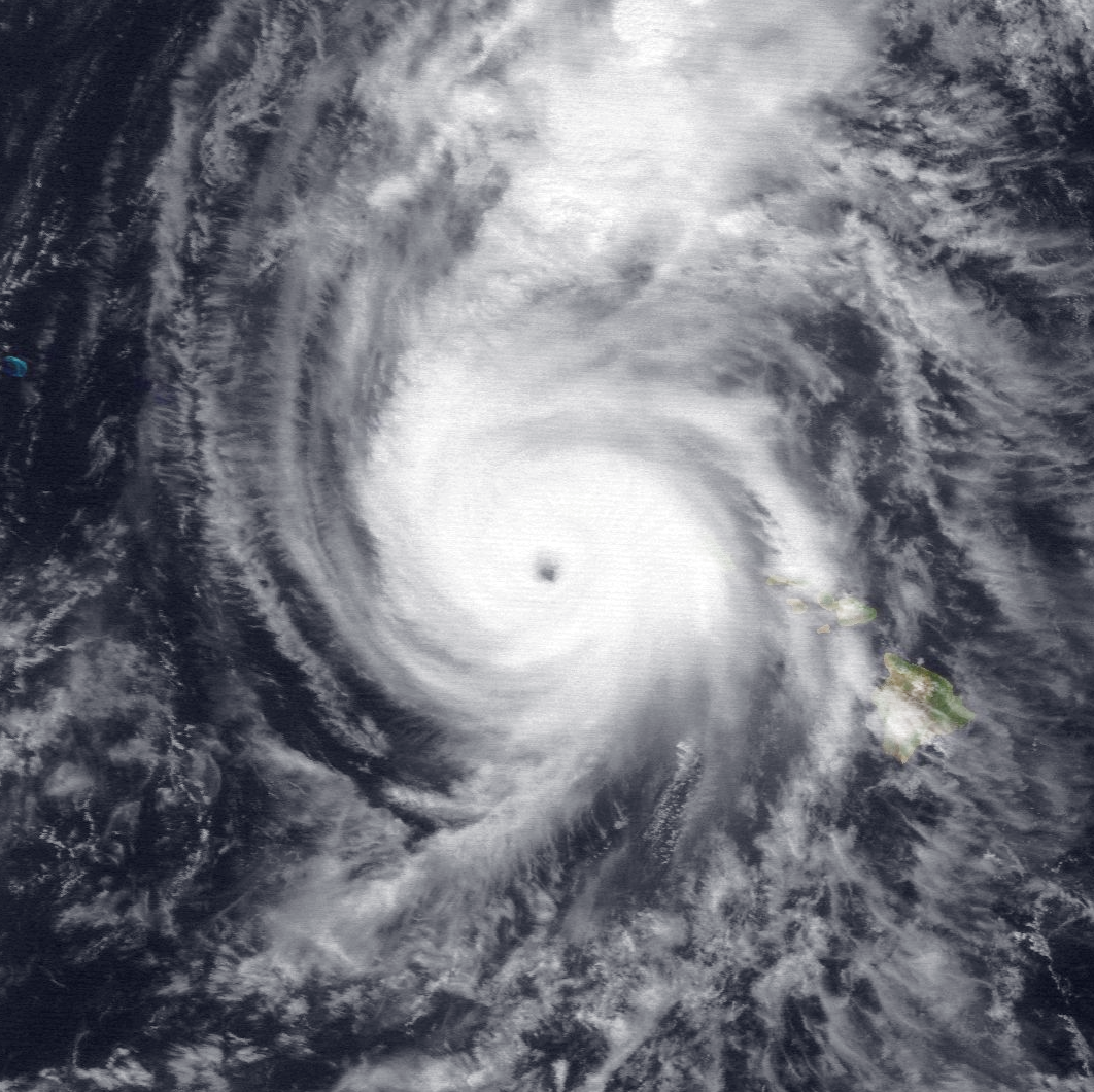
Hurricane Iniki
Hurricane Iniki (/iːˈniːkiː/ ee-NEE-kee; Hawaiian: ʻiniki meaning "strong and piercing wind") was a hurricane that struck the island of Kauaʻi on September 11, 1992. It was the most powerful hurricane to strike Hawaiʻi in recorded history, and the only hurricane to directly affect the state during the 1992 Pacific hurricane season. Forming on September 5, 1992, it was the first hurricane to hit the state since Hurricane Iwa in the 1982 season, and the only known major hurricane to hit the state. Iniki dissipated on September 13, about halfway between Hawaii and Alaska.
Iniki caused around $3.1 billion (1992 USD) in damage and seven deaths. This made Iniki, at the time, the costliest natural disaster on record in the state, as well as the third-costliest to hit the U.S. It struck just 18 days after Florida was devastated by Hurricane Andrew, which was the costliest tropical cyclone ever at the time.
The Central Pacific Hurricane Center (CPHC) failed to issue tropical cyclone warnings and watches 24 hours in advance. The hurricane destroyed more than 1,400 houses on Kauaʻi and severely damaged more than 5,000. Though not directly in the path of the eye, Oʻahu experienced moderate damage from wind and storm surge.
The origin of Iniki is unclear, but it may have begun as a tropical wave that exited the west African coast on August 18. It moved westward across northern South America and Central America, entering the eastern Pacific Ocean on August 28. On September 5, Tropical Depression Eighteen-E developed from the wave, about 1,700 miles (2,700 km) southwest of the southern tip of the Baja California peninsula, or 1,550 miles (2,490 km) east-southeast of Hilo. Upon its formation, the depression had a ragged area of convection, and the National Hurricane Center anticipated minimal strengthening over the subsequent few days. This was due to the convective structure having poorly defined outflow, or ventilation. Warm sea surface temperatures, 2–5° F (1–3° C) above normal, were considered a positive factor. On September 6, the depression crossed 140° W, entering the area of warning responsibility of the Central Pacific Hurricane Center (CPHC). On that day, the CPHC anticipated that the depression would dissipate within 24 hours, and ceased issuing advisories, but the depression reorganized on the next day, and warnings were reissued. Steered by a subtropical ridge to the north, the depression continued westward, or slightly south of due west. On September 8, the CPHC upgraded the depression to tropical storm status, giving it the name Iniki, which is Hawaiian for a sharp and piercing wind.
Iniki gradually intensified as its track shifted to the north. It moved around the western edge of the subtropical ridge, which was weakening due to an upper-level trough moving eastward from the International Date Line. Typically, the subtropical ridge keeps storms away from the Hawaiian islands. On September 9, Iniki strengthened into a hurricane, and the next day it passed about 300 miles (480 km) south of Ka Lae, the southernmost point of the Big Island of Hawaii. The hurricane slowed and curved toward the north while continuing to intensify. On September 10, a reconnaissance aircraft flew into Iniki, observing sustained winds of 115 mph (185 km/h), which is a major hurricane, or a Category 3 on the Saffir-Simpson scale. The approaching trough caused Iniki to accelerate to the north-northeast toward the western Hawaiian islands.
On September 11, a reconnaissance aircraft observed maximum sustained winds of 145 mph (233 km/h), with gusts to 173 mph (278 km/h), making it a Category 4 hurricane. The flight also observed a minimum barometric pressure of 938 mbar (27.7 inHg), the lowest ever observed in the Central Pacific at the time. Simultaneously, the hurricane was about 130 mi (210 km) southwest of Lihue. Iniki weakened slightly after its peak, and its eye made landfall on the southern coast of Kauai near Waimea with winds of 140 mph (230 km/h), making it the strongest hurricane on record to strike Hawaii. Iniki moved rapidly across the island, and about 40 minutes after landfall, it reemerged into the Pacific Ocean as it accelerated away from the state. The hurricane thereafter weakened, dropping to tropical storm status by September 13. That day, Iniki transitioned into an extratropical cyclone as it integrated with an approaching cold front about halfway between Hawaii and Alaska.
While Iniki was in its development stages, various tropical cyclone forecast models anticipated a range of possibilities for the hurricane's future trajectory, ranging from a landfall on the Big Island to a path to the west, away from the state. The hurricane initially followed a trajectory similar to other storms in the region, passing south of the state. The CPHC relied on the Miami-based National Hurricane Center for the models, and lacked a detailed analysis on each model run, which caused errors in forecasting. The agency also had limited satellite imagery and direct observations to track the hurricane. As such, the CPHC failed to issue tropical cyclone warnings and watches for the hurricane well in advance, although the agency warned for the potential of high surf. For several days before the disaster, the CPHC and the news media forecast Iniki to remain well south of the island chain.
Two days before the storm struck, the Naval Western Oceanography Center on Oʻahu recommended that the United States Navy fleet at the Pearl Harbor Shipyard to start storm preparations. A few Naval facilities were evacuated, some ahead of official hurricane warnings from the CPHC. Early on September 11, less than 24 hours before Iniki made landfall, the CPHC issued a hurricane watch for Kauaʻi, Niihau, and the northwestern Hawaiian islands to the French Frigate Shoals. A few hours later, the agency upgraded the watch to a hurricane warning for Kauaʻi and Niihau. A hurricane warning was later issued for Oʻahu, while a tropical storm watch was issued for the islands of Maui County. Warning sirens blared on Kauaʻi and Oʻahu to warn the public of the approaching storm. The hurricane warning for Kauaʻi was downgraded to a tropical storm warning after Iniki departed the island, causing some confusion whether there was another storm approaching the area. Reports about the storm were disseminated by radio, newspapers, and news stations. After the hurricane warnings were issued, TV stations began 24-hour coverage of the storm. Residents responded well to the hurricane, in part due to the scenes of destruction from Hurricane Andrew in south Florida three weeks earlier. Iniki nearly struck the Central Pacific Hurricane Center in Honolulu. Had it hit there, Iniki, along with Hurricane Andrew and Typhoon Omar, would have struck each of the three National Weather Service offices responsible for tropical cyclone warnings within a two-month period.
Hub AI
Hurricane Iniki AI simulator
(@Hurricane Iniki_simulator)
Hurricane Iniki
Hurricane Iniki (/iːˈniːkiː/ ee-NEE-kee; Hawaiian: ʻiniki meaning "strong and piercing wind") was a hurricane that struck the island of Kauaʻi on September 11, 1992. It was the most powerful hurricane to strike Hawaiʻi in recorded history, and the only hurricane to directly affect the state during the 1992 Pacific hurricane season. Forming on September 5, 1992, it was the first hurricane to hit the state since Hurricane Iwa in the 1982 season, and the only known major hurricane to hit the state. Iniki dissipated on September 13, about halfway between Hawaii and Alaska.
Iniki caused around $3.1 billion (1992 USD) in damage and seven deaths. This made Iniki, at the time, the costliest natural disaster on record in the state, as well as the third-costliest to hit the U.S. It struck just 18 days after Florida was devastated by Hurricane Andrew, which was the costliest tropical cyclone ever at the time.
The Central Pacific Hurricane Center (CPHC) failed to issue tropical cyclone warnings and watches 24 hours in advance. The hurricane destroyed more than 1,400 houses on Kauaʻi and severely damaged more than 5,000. Though not directly in the path of the eye, Oʻahu experienced moderate damage from wind and storm surge.
The origin of Iniki is unclear, but it may have begun as a tropical wave that exited the west African coast on August 18. It moved westward across northern South America and Central America, entering the eastern Pacific Ocean on August 28. On September 5, Tropical Depression Eighteen-E developed from the wave, about 1,700 miles (2,700 km) southwest of the southern tip of the Baja California peninsula, or 1,550 miles (2,490 km) east-southeast of Hilo. Upon its formation, the depression had a ragged area of convection, and the National Hurricane Center anticipated minimal strengthening over the subsequent few days. This was due to the convective structure having poorly defined outflow, or ventilation. Warm sea surface temperatures, 2–5° F (1–3° C) above normal, were considered a positive factor. On September 6, the depression crossed 140° W, entering the area of warning responsibility of the Central Pacific Hurricane Center (CPHC). On that day, the CPHC anticipated that the depression would dissipate within 24 hours, and ceased issuing advisories, but the depression reorganized on the next day, and warnings were reissued. Steered by a subtropical ridge to the north, the depression continued westward, or slightly south of due west. On September 8, the CPHC upgraded the depression to tropical storm status, giving it the name Iniki, which is Hawaiian for a sharp and piercing wind.
Iniki gradually intensified as its track shifted to the north. It moved around the western edge of the subtropical ridge, which was weakening due to an upper-level trough moving eastward from the International Date Line. Typically, the subtropical ridge keeps storms away from the Hawaiian islands. On September 9, Iniki strengthened into a hurricane, and the next day it passed about 300 miles (480 km) south of Ka Lae, the southernmost point of the Big Island of Hawaii. The hurricane slowed and curved toward the north while continuing to intensify. On September 10, a reconnaissance aircraft flew into Iniki, observing sustained winds of 115 mph (185 km/h), which is a major hurricane, or a Category 3 on the Saffir-Simpson scale. The approaching trough caused Iniki to accelerate to the north-northeast toward the western Hawaiian islands.
On September 11, a reconnaissance aircraft observed maximum sustained winds of 145 mph (233 km/h), with gusts to 173 mph (278 km/h), making it a Category 4 hurricane. The flight also observed a minimum barometric pressure of 938 mbar (27.7 inHg), the lowest ever observed in the Central Pacific at the time. Simultaneously, the hurricane was about 130 mi (210 km) southwest of Lihue. Iniki weakened slightly after its peak, and its eye made landfall on the southern coast of Kauai near Waimea with winds of 140 mph (230 km/h), making it the strongest hurricane on record to strike Hawaii. Iniki moved rapidly across the island, and about 40 minutes after landfall, it reemerged into the Pacific Ocean as it accelerated away from the state. The hurricane thereafter weakened, dropping to tropical storm status by September 13. That day, Iniki transitioned into an extratropical cyclone as it integrated with an approaching cold front about halfway between Hawaii and Alaska.
While Iniki was in its development stages, various tropical cyclone forecast models anticipated a range of possibilities for the hurricane's future trajectory, ranging from a landfall on the Big Island to a path to the west, away from the state. The hurricane initially followed a trajectory similar to other storms in the region, passing south of the state. The CPHC relied on the Miami-based National Hurricane Center for the models, and lacked a detailed analysis on each model run, which caused errors in forecasting. The agency also had limited satellite imagery and direct observations to track the hurricane. As such, the CPHC failed to issue tropical cyclone warnings and watches for the hurricane well in advance, although the agency warned for the potential of high surf. For several days before the disaster, the CPHC and the news media forecast Iniki to remain well south of the island chain.
Two days before the storm struck, the Naval Western Oceanography Center on Oʻahu recommended that the United States Navy fleet at the Pearl Harbor Shipyard to start storm preparations. A few Naval facilities were evacuated, some ahead of official hurricane warnings from the CPHC. Early on September 11, less than 24 hours before Iniki made landfall, the CPHC issued a hurricane watch for Kauaʻi, Niihau, and the northwestern Hawaiian islands to the French Frigate Shoals. A few hours later, the agency upgraded the watch to a hurricane warning for Kauaʻi and Niihau. A hurricane warning was later issued for Oʻahu, while a tropical storm watch was issued for the islands of Maui County. Warning sirens blared on Kauaʻi and Oʻahu to warn the public of the approaching storm. The hurricane warning for Kauaʻi was downgraded to a tropical storm warning after Iniki departed the island, causing some confusion whether there was another storm approaching the area. Reports about the storm were disseminated by radio, newspapers, and news stations. After the hurricane warnings were issued, TV stations began 24-hour coverage of the storm. Residents responded well to the hurricane, in part due to the scenes of destruction from Hurricane Andrew in south Florida three weeks earlier. Iniki nearly struck the Central Pacific Hurricane Center in Honolulu. Had it hit there, Iniki, along with Hurricane Andrew and Typhoon Omar, would have struck each of the three National Weather Service offices responsible for tropical cyclone warnings within a two-month period.