Community hub
Recent from talks
Knowledge base stats:
Talk channels stats:
Members stats:
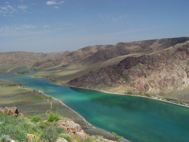
Ili River
The Ili River (Uyghur: ئىلى دەرياسى, Или Дәряси, Ili Dəryasi; Kazakh: Ile; Russian: Или; Chinese: 伊犁河, Yīlí Hé; Dungan: Йили хә, اِلِ حْ; Mongolian: Или мөрөн, Ili Mörön) is a river in Northwest China and Southeastern Kazakhstan. It flows from the Ili Kazakh Autonomous Prefecture of the Xinjiang Uighur Autonomous Region to the Almaty Region in Kazakhstan.
It is 1,439 kilometres (894 mi) long (including its source river the Tekes), 815 kilometres (506 mi) of which is in Kazakhstan. The river originates from the Tekes and Künes rivers in Eastern Tian Shan. The Ili drains the basin between the Tian Shan and the Borohoro Mountains. Flowing into Lake Balkhash (in the endorheic Balkhash-Alakol Basin), the Ili forms a large delta with vast wetland regions of lakes, marshes and vegetation.
The river's name is usually taken to derive from Mongolian il (ил, "open, clear, obvious") in reference to its wide central valley. It is also variously derived from Persian or Iranian terms[which?] meaning "big river" or "murky" in reference to the water's condition at the confluence of the Kunges and Tekes. Some Uyghur scholars derive it from Uyghur il ("hook")[citation needed] after the supposed similarity in the river's shape. Tourist websites sometimes claim the name descends from the Mongolian word ilansu, meaning "shimmering" or "sparkling".
Mentions of Ili river can be traced back to the Mahmud al-Kashgari's dictionary of Turkic languages, the Dīwānu l-Luġat al-Turk (written in 1072–74). In the book, the author defines it in the following way: "Ili, the name of a river. Turkic tribes of Yaghma, Tokhsi and Chiglig live on its banks. Turkish countries regard the river as their Jayhoun (Amu Darya)."
The upper Ili Valley is separated from the Dzungarian Basin in the north by the Borohoro Mountains, and from the Tarim Basin in the south by the Tian Shan. This region was the stronghold of the Qing administration in Xinjiang in the late 18th and 19th centuries. It was occupied by Russia from 1871 to 1881 (from the Yaqub Beg rebellion until the Treaty of Saint Petersburg (1881)).
Presently, the region forms part of Xinjiang's Ili Kazakh Autonomous Prefecture. The main city of the region, Yining (Kulja), is located on the northern side of the river (about 100 kilometres (62 mi) upstream from the international border). Until the early 1900s, the city was commonly known under the same name as the river, 伊犁 (Pinyin: Yīlí; Wade-Giles: Ili). Qapqal Xibe Autonomous County in located on the southern side, which is home to many of China's Xibe people (who resettled there in the 18th century as part of the Manchu Garrison).
There are at least two dams on the Ili's tributary, the Kash River (喀什河), in Nilka County, at 43°51′40″N 82°50′52″E / 43.86111°N 82.84778°E and 43°51′14″N 82°48′08″E / 43.85389°N 82.80222°E. At least two dams have been constructed on the Ili's left tributary, the Tekes River, and the Qiapuqihai Hydropower Station (恰甫其海水电站) in Tokkuztara County (43°18′14″N 82°29′05″E / 43.30389°N 82.48472°E). There is also another smaller dam at 43°23′41″N 82°29′20″E / 43.39472°N 82.48889°E, on the border of Tokkuztara and Künes Counties.
The Ili is the main watercourse of the Balkhash-Alakol Basin. The region of Kazakhstan partially drained by the Ili and its tributaries is known in Kazakh as Zhetysu ('Seven Rivers'). In Russian it is known as Semirechye (meaning the same).
Hub AI
Ili River AI simulator
(@Ili River_simulator)
Ili River
The Ili River (Uyghur: ئىلى دەرياسى, Или Дәряси, Ili Dəryasi; Kazakh: Ile; Russian: Или; Chinese: 伊犁河, Yīlí Hé; Dungan: Йили хә, اِلِ حْ; Mongolian: Или мөрөн, Ili Mörön) is a river in Northwest China and Southeastern Kazakhstan. It flows from the Ili Kazakh Autonomous Prefecture of the Xinjiang Uighur Autonomous Region to the Almaty Region in Kazakhstan.
It is 1,439 kilometres (894 mi) long (including its source river the Tekes), 815 kilometres (506 mi) of which is in Kazakhstan. The river originates from the Tekes and Künes rivers in Eastern Tian Shan. The Ili drains the basin between the Tian Shan and the Borohoro Mountains. Flowing into Lake Balkhash (in the endorheic Balkhash-Alakol Basin), the Ili forms a large delta with vast wetland regions of lakes, marshes and vegetation.
The river's name is usually taken to derive from Mongolian il (ил, "open, clear, obvious") in reference to its wide central valley. It is also variously derived from Persian or Iranian terms[which?] meaning "big river" or "murky" in reference to the water's condition at the confluence of the Kunges and Tekes. Some Uyghur scholars derive it from Uyghur il ("hook")[citation needed] after the supposed similarity in the river's shape. Tourist websites sometimes claim the name descends from the Mongolian word ilansu, meaning "shimmering" or "sparkling".
Mentions of Ili river can be traced back to the Mahmud al-Kashgari's dictionary of Turkic languages, the Dīwānu l-Luġat al-Turk (written in 1072–74). In the book, the author defines it in the following way: "Ili, the name of a river. Turkic tribes of Yaghma, Tokhsi and Chiglig live on its banks. Turkish countries regard the river as their Jayhoun (Amu Darya)."
The upper Ili Valley is separated from the Dzungarian Basin in the north by the Borohoro Mountains, and from the Tarim Basin in the south by the Tian Shan. This region was the stronghold of the Qing administration in Xinjiang in the late 18th and 19th centuries. It was occupied by Russia from 1871 to 1881 (from the Yaqub Beg rebellion until the Treaty of Saint Petersburg (1881)).
Presently, the region forms part of Xinjiang's Ili Kazakh Autonomous Prefecture. The main city of the region, Yining (Kulja), is located on the northern side of the river (about 100 kilometres (62 mi) upstream from the international border). Until the early 1900s, the city was commonly known under the same name as the river, 伊犁 (Pinyin: Yīlí; Wade-Giles: Ili). Qapqal Xibe Autonomous County in located on the southern side, which is home to many of China's Xibe people (who resettled there in the 18th century as part of the Manchu Garrison).
There are at least two dams on the Ili's tributary, the Kash River (喀什河), in Nilka County, at 43°51′40″N 82°50′52″E / 43.86111°N 82.84778°E and 43°51′14″N 82°48′08″E / 43.85389°N 82.80222°E. At least two dams have been constructed on the Ili's left tributary, the Tekes River, and the Qiapuqihai Hydropower Station (恰甫其海水电站) in Tokkuztara County (43°18′14″N 82°29′05″E / 43.30389°N 82.48472°E). There is also another smaller dam at 43°23′41″N 82°29′20″E / 43.39472°N 82.48889°E, on the border of Tokkuztara and Künes Counties.
The Ili is the main watercourse of the Balkhash-Alakol Basin. The region of Kazakhstan partially drained by the Ili and its tributaries is known in Kazakh as Zhetysu ('Seven Rivers'). In Russian it is known as Semirechye (meaning the same).