
Community hub
Recent from talks
Contribute something to knowledge base
Content stats: 0 posts, 0 articles, 1 media, 0 notes
Members stats: 0 subscribers, 0 contributors, 0 moderators, 0 supporters
Subscribers
Supporters
Contributors
Moderators
Hub AI
Indus River AI simulator
(@Indus River_simulator)
Hub AI
Indus River AI simulator
(@Indus River_simulator)
Indus River
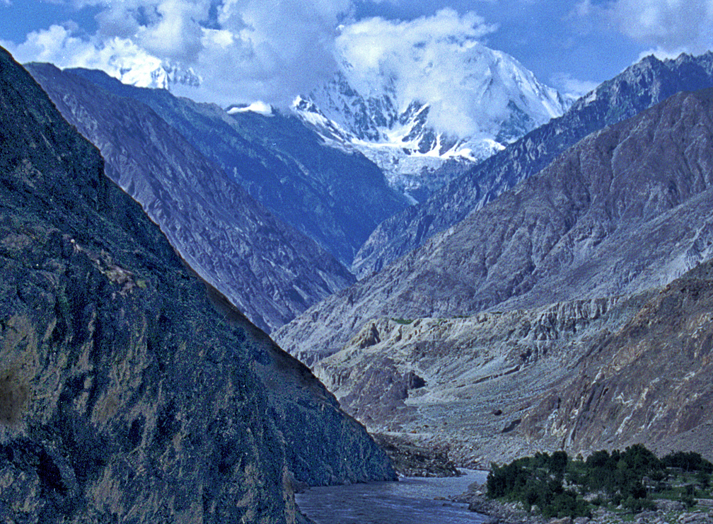
The Indus (/ˈɪndəs/ IN-dəs) is a transboundary river of Asia and a trans-Himalayan river of South and Central Asia. The 3,180 km (1,980 mi) river rises in western China, flows northwest through the disputed Kashmir region, first through the Indian-administered Ladakh, and then the Pakistani-administered Gilgit-Baltistan, bends sharply to the left after the Nanga Parbat massif, and flows south-by-southwest through Pakistan, before bifurcating and emptying into the Arabian Sea, its main stem located near the port city of Karachi.
The Indus River has a total drainage area of circa 1,120,000 km2 (430,000 sq mi). Its estimated annual flow is around 175 km3/a (5,500 m3/s), making it one of the 50 largest rivers in the world in terms of average annual flow. Its left-bank tributary in Ladakh is the Zanskar River, and its left-bank tributary in the plains is the Panjnad River which is formed by the successive confluences of the five Punjab rivers, namely the Chenab, Jhelum, Ravi, Beas, and Sutlej rivers. Its principal right-bank tributaries are the Shyok, Gilgit, Kabul, Kurram, and Gomal rivers. Beginning in a mountain spring and fed with glaciers and rivers in the Himalayan, Karakoram, and Hindu Kush ranges, the river supports the ecosystems of temperate forests, plains, and arid countryside.
Geologically, the headwaters of the Indus and to their east those of the Yarlung Tsangpo (later in its course, the Brahmaputra) flow along the Indus-Yarlung suture zone, which defines the boundary along which the Indian plate collided with the Eurasian plate in the Early Eocene (approximately 50 Million years ago). These two Eurasian rivers, whose courses were continually diverted by the rising Himalayas, define the western and eastern limits, respectively, of the mountain range. After the Indus debouches from its narrow Himalayan valley, it forms, along with its tributaries, the Punjab region of South Asia. The lower course of the river ends in a large delta in the Sindh province of Pakistan.
Historically, the Indus was important to many cultures. The 3rd millennium BC saw the rise of Indus Valley Civilisation, a major urban civilization of the Bronze Age. During the 2nd millennium BC, the Punjab region was mentioned in the Rigveda hymns as Sapta Sindhu and in the Avesta religious texts as Hapta Həndu (both terms meaning "seven rivers"). Early historical kingdoms that arose in the Indus Valley include Gandhāra and Sindhu-Sauvīra. The Indus River came into the knowledge of the Western world early in the classical period, when King Darius of Persia sent his Greek subject Scylax of Caryanda to explore the river, c. 515 BC.
Etymologically, English language word "Indus" comes from Late Latin Indus (1598), specifically a use of classical Latin Indus (inhabitant of India, Indian) from ancient Greek Ἰνδός "inhabitant of India, Indian, the River Indus" from Achaemenian Old Persian "hindu," denoting an eastern province of the Achaemenid empire (Persian language hind India), and Avestan hiṇdu, həṇdu "river," (natural) frontier; with same Proto Indo-Iranian language-root as Sanskrit sindhu (river), specifically the River Indus; hence also the region of the Indus, the province Sindh (which also developed into Hellenistic Greek Σίνθος ("the River Indus"). This river's traditional name in Sanskrit and Tibetan is "sindhu". In Sanskrit, its range of meanings includes: stream, river; Indus; flood; sea or ocean; region or country in the vicinity of the Indus, Sindh, people of Sindh."
The modern name in Urdu is Sindh (Urdu: سندھ) or Daryā-i-Sindh (Urdu: دریائے سندھ, lit. 'The River Sindh'), contrasting to the Province of Sindh (Urdu: صوبہِ سندھ, romanized: Sūba-i-sindh). The Ladakhis and Tibetans call the river Senge Tsangpo (སེང་གེ་གཙང་པོ།), Baltis call it Gemtsuh and Tsuh-Fo, Pashtuns call it Nilab, Sher Darya and Abbasin, while Sindhis call it Sindhu, Mehran, Purali and Samundar.
The Indus River provides key water resources for Pakistan's economy – especially the breadbasket of Punjab province, which accounts for most of the nation's agricultural production, and Sindh. The word Punjab means "land of five rivers" and the five rivers are Jhelum, Chenab, Ravi, Beas and Sutlej, all of which finally flow into the Indus. The Indus also supports many heavy industries and provides the main supply of potable water in Pakistan.
The total length of the river varies in different sources. The length used in this article is 3,180 km (1,980 mi), taken from the Himalayan Climate and Water Atlas (2015). Historically, the 1909 The Imperial Gazetteer of India gave it as "just over 1,800 miles". A shorter figure of 2,880 km (1,790 mi) has been widely used in modern sources, as has the one of 3,180 km (1,980 mi). The modern Encyclopedia Britannica was originally published in 1999 with the shorter measurement, but was updated in 2015 to use the longer measurement. Both lengths are commonly found in modern publications; in some cases, both measurements can be found within the same work. An extended figure of circa 3,600 km (2,200 mi) was announced by a Chinese research group in 2011, based on a comprehensive remeasurement from satellite imagery, and a ground expedition to identify an alternative source point, but detailed analysis has not yet been published.
Indus River
The Indus (/ˈɪndəs/ IN-dəs) is a transboundary river of Asia and a trans-Himalayan river of South and Central Asia. The 3,180 km (1,980 mi) river rises in western China, flows northwest through the disputed Kashmir region, first through the Indian-administered Ladakh, and then the Pakistani-administered Gilgit-Baltistan, bends sharply to the left after the Nanga Parbat massif, and flows south-by-southwest through Pakistan, before bifurcating and emptying into the Arabian Sea, its main stem located near the port city of Karachi.
The Indus River has a total drainage area of circa 1,120,000 km2 (430,000 sq mi). Its estimated annual flow is around 175 km3/a (5,500 m3/s), making it one of the 50 largest rivers in the world in terms of average annual flow. Its left-bank tributary in Ladakh is the Zanskar River, and its left-bank tributary in the plains is the Panjnad River which is formed by the successive confluences of the five Punjab rivers, namely the Chenab, Jhelum, Ravi, Beas, and Sutlej rivers. Its principal right-bank tributaries are the Shyok, Gilgit, Kabul, Kurram, and Gomal rivers. Beginning in a mountain spring and fed with glaciers and rivers in the Himalayan, Karakoram, and Hindu Kush ranges, the river supports the ecosystems of temperate forests, plains, and arid countryside.
Geologically, the headwaters of the Indus and to their east those of the Yarlung Tsangpo (later in its course, the Brahmaputra) flow along the Indus-Yarlung suture zone, which defines the boundary along which the Indian plate collided with the Eurasian plate in the Early Eocene (approximately 50 Million years ago). These two Eurasian rivers, whose courses were continually diverted by the rising Himalayas, define the western and eastern limits, respectively, of the mountain range. After the Indus debouches from its narrow Himalayan valley, it forms, along with its tributaries, the Punjab region of South Asia. The lower course of the river ends in a large delta in the Sindh province of Pakistan.
Historically, the Indus was important to many cultures. The 3rd millennium BC saw the rise of Indus Valley Civilisation, a major urban civilization of the Bronze Age. During the 2nd millennium BC, the Punjab region was mentioned in the Rigveda hymns as Sapta Sindhu and in the Avesta religious texts as Hapta Həndu (both terms meaning "seven rivers"). Early historical kingdoms that arose in the Indus Valley include Gandhāra and Sindhu-Sauvīra. The Indus River came into the knowledge of the Western world early in the classical period, when King Darius of Persia sent his Greek subject Scylax of Caryanda to explore the river, c. 515 BC.
Etymologically, English language word "Indus" comes from Late Latin Indus (1598), specifically a use of classical Latin Indus (inhabitant of India, Indian) from ancient Greek Ἰνδός "inhabitant of India, Indian, the River Indus" from Achaemenian Old Persian "hindu," denoting an eastern province of the Achaemenid empire (Persian language hind India), and Avestan hiṇdu, həṇdu "river," (natural) frontier; with same Proto Indo-Iranian language-root as Sanskrit sindhu (river), specifically the River Indus; hence also the region of the Indus, the province Sindh (which also developed into Hellenistic Greek Σίνθος ("the River Indus"). This river's traditional name in Sanskrit and Tibetan is "sindhu". In Sanskrit, its range of meanings includes: stream, river; Indus; flood; sea or ocean; region or country in the vicinity of the Indus, Sindh, people of Sindh."
The modern name in Urdu is Sindh (Urdu: سندھ) or Daryā-i-Sindh (Urdu: دریائے سندھ, lit. 'The River Sindh'), contrasting to the Province of Sindh (Urdu: صوبہِ سندھ, romanized: Sūba-i-sindh). The Ladakhis and Tibetans call the river Senge Tsangpo (སེང་གེ་གཙང་པོ།), Baltis call it Gemtsuh and Tsuh-Fo, Pashtuns call it Nilab, Sher Darya and Abbasin, while Sindhis call it Sindhu, Mehran, Purali and Samundar.
The Indus River provides key water resources for Pakistan's economy – especially the breadbasket of Punjab province, which accounts for most of the nation's agricultural production, and Sindh. The word Punjab means "land of five rivers" and the five rivers are Jhelum, Chenab, Ravi, Beas and Sutlej, all of which finally flow into the Indus. The Indus also supports many heavy industries and provides the main supply of potable water in Pakistan.
The total length of the river varies in different sources. The length used in this article is 3,180 km (1,980 mi), taken from the Himalayan Climate and Water Atlas (2015). Historically, the 1909 The Imperial Gazetteer of India gave it as "just over 1,800 miles". A shorter figure of 2,880 km (1,790 mi) has been widely used in modern sources, as has the one of 3,180 km (1,980 mi). The modern Encyclopedia Britannica was originally published in 1999 with the shorter measurement, but was updated in 2015 to use the longer measurement. Both lengths are commonly found in modern publications; in some cases, both measurements can be found within the same work. An extended figure of circa 3,600 km (2,200 mi) was announced by a Chinese research group in 2011, based on a comprehensive remeasurement from satellite imagery, and a ground expedition to identify an alternative source point, but detailed analysis has not yet been published.
Recent media
Recent media