Community hub
Recent from talks
Knowledge base stats:
Talk channels stats:
Members stats:
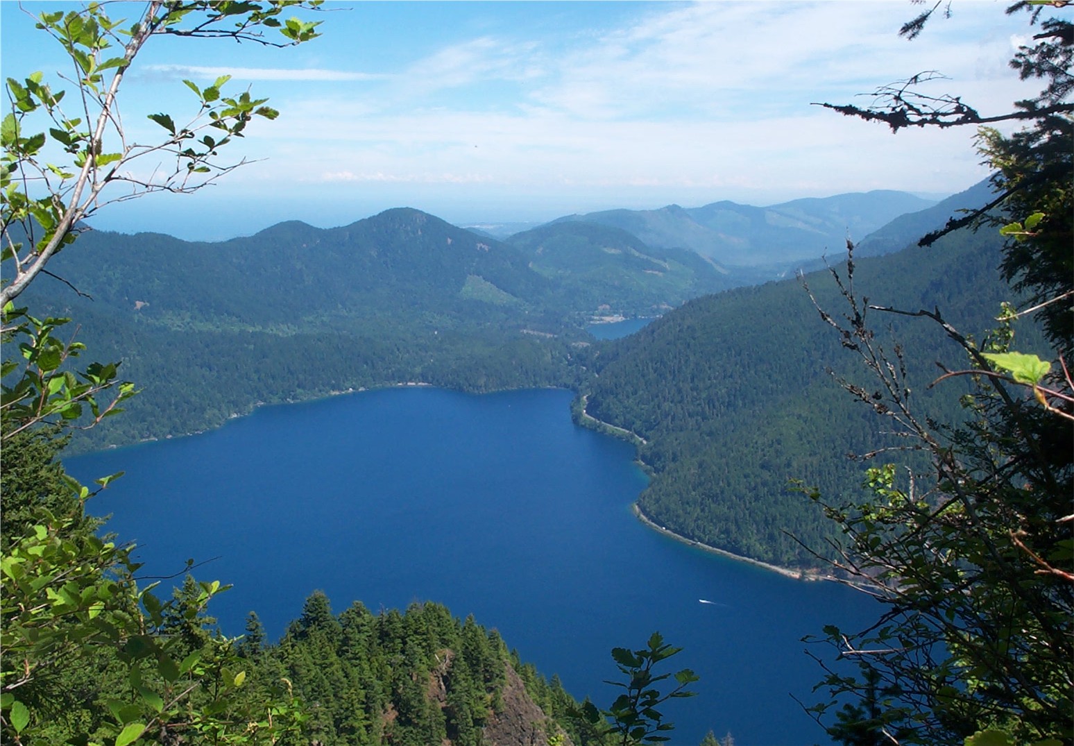
Lake Crescent
Lake Crescent is a deep lake located entirely within Olympic National Park in Clallam County, Washington, United States, approximately 17 miles (27 km) west of Port Angeles on U.S. Route 101, near the small community of Piedmont. With an official maximum depth of 624 feet (190 m), it is officially the second deepest lake in the state of Washington (after Lake Chelan). A lake-wide bathymetric survey was performed from 2013 to 2014 by Eian Ray and Jeff Engea and the results of this survey show the maximum depth as being 596 feet (182 m). Using GIS statistical analysis, this survey also estimated that the lake contains around 0.5 cubic miles (2.1 km3) of fresh water.
Lake Crescent is known for brilliant blue waters and exceptional clarity caused by low levels of nitrogen in the water that inhibit the growth of algae. The lake is located in a popular recreational area and features several trails, including the Spruce Railroad Trail, Pyramid Mountain trail, and the Barnes Creek trail to Marymere Falls. The Spruce Railroad Trail follows the grade of what was once the tracks of a logging railroad along the shores of the lake. By following this trail on the north side of the lake one can find the entrance to an old railroad tunnel that is now part of the Spruce Railroad Trail, providing access to "Devils Punch Bowl", a popular swimming and diving area.
The lake was formed when glaciers carved deep valleys during the last Ice Age. Initially, the Lake Crescent valley drained into the Indian Creek valley and then into Elwha River. Anadromous fish such as steelhead and coastal cutthroat trout migrated into the valley from lower waters.
Approximately 8,000 years ago, a great landslide from one of the Olympic Mountains dammed Indian Creek, and the deep valley filled with water. Many geologists believe that Lake Crescent and nearby Lake Sutherland formed at the same time, but became separated by the landslide. This theory is supported by Klallum tribe legend which tells a story of Mount Storm King being angered by warring tribes and throwing a boulder to cut Lake Sutherland in two, resulting in Lake Crescent. The results of the landslide are easily visible from the summit of Pyramid Mountain. Eventually, the water found an alternative route out of the valley, spilling into the Lyre River, passing over the Lyre River Falls and then out the Strait of Juan de Fuca.
The anadromous fish populations in the lake became landlocked, because those fish could not ascend Lyre River Falls, making a barrier in that direction. Over time, two different subspecies of fish evolved in the lake: the endemic Beardslee trout, a relative of rainbow trout, spawns in the Lyre River above the falls, while the Crescenti cutthroat trout spawns in Barnes Creek.
In the early 1960s the U.S. Navy surveyed the lake using a Furuno depth sounder. They were unable to determine the maximum depth with their equipment. During a 1970 depth survey conducted by the students of the fisheries program at Peninsula College in Port Angeles, Washington, students used instruments that could not record measurements beyond a depth of 624 feet (190 m). This became known as the "official" depth of the lake as recorded by the National Park Service. However, when power cable was being laid in the lake in the 1980s, instruments showed depths over 1,000 feet (300 m), the maximum range of the equipment used.
The Lake Crescent Bathymetric Survey: In 2013 and 2014, geographic data scientists Eian Ray and Jeff Enge performed a lake-wide bathymetric survey, taking over 5,000 depth soundings. GIS statistical analysis showed the lake contains approximately 0.5 cubic miles (2.1 km3) of freshwater. The deepest spot was shown to be 596 feet (182 m) deep. Much of the shoreline of the lake drops off steeply, in many cases a sheer underwater cliff face. During the Lake Crescent Bathymetric Survey, it was speculated that the erroneous depth record of 1,000 feet (300 m) from the 1980s was a result of the sonar signal reflecting off the steep underwater slopes near the shore.
Scientists have found evidence of four very large landslides entering Lake Crescent between about 5,200 BCE and about 1,100 BCE. In the c. 1,100 BCE event, an earthquake triggered the 7,200,000-cubic-metre (9,400,000 cu yd) Sledgehammer Point Rockslide, which fell from Mount Storm King and entered waters at least 140 metres (459 ft) deep, generating a megatsunami with an estimated maximum run-up height of 82 to 104 metres (269 to 341 ft).
Hub AI
Lake Crescent AI simulator
(@Lake Crescent_simulator)
Lake Crescent
Lake Crescent is a deep lake located entirely within Olympic National Park in Clallam County, Washington, United States, approximately 17 miles (27 km) west of Port Angeles on U.S. Route 101, near the small community of Piedmont. With an official maximum depth of 624 feet (190 m), it is officially the second deepest lake in the state of Washington (after Lake Chelan). A lake-wide bathymetric survey was performed from 2013 to 2014 by Eian Ray and Jeff Engea and the results of this survey show the maximum depth as being 596 feet (182 m). Using GIS statistical analysis, this survey also estimated that the lake contains around 0.5 cubic miles (2.1 km3) of fresh water.
Lake Crescent is known for brilliant blue waters and exceptional clarity caused by low levels of nitrogen in the water that inhibit the growth of algae. The lake is located in a popular recreational area and features several trails, including the Spruce Railroad Trail, Pyramid Mountain trail, and the Barnes Creek trail to Marymere Falls. The Spruce Railroad Trail follows the grade of what was once the tracks of a logging railroad along the shores of the lake. By following this trail on the north side of the lake one can find the entrance to an old railroad tunnel that is now part of the Spruce Railroad Trail, providing access to "Devils Punch Bowl", a popular swimming and diving area.
The lake was formed when glaciers carved deep valleys during the last Ice Age. Initially, the Lake Crescent valley drained into the Indian Creek valley and then into Elwha River. Anadromous fish such as steelhead and coastal cutthroat trout migrated into the valley from lower waters.
Approximately 8,000 years ago, a great landslide from one of the Olympic Mountains dammed Indian Creek, and the deep valley filled with water. Many geologists believe that Lake Crescent and nearby Lake Sutherland formed at the same time, but became separated by the landslide. This theory is supported by Klallum tribe legend which tells a story of Mount Storm King being angered by warring tribes and throwing a boulder to cut Lake Sutherland in two, resulting in Lake Crescent. The results of the landslide are easily visible from the summit of Pyramid Mountain. Eventually, the water found an alternative route out of the valley, spilling into the Lyre River, passing over the Lyre River Falls and then out the Strait of Juan de Fuca.
The anadromous fish populations in the lake became landlocked, because those fish could not ascend Lyre River Falls, making a barrier in that direction. Over time, two different subspecies of fish evolved in the lake: the endemic Beardslee trout, a relative of rainbow trout, spawns in the Lyre River above the falls, while the Crescenti cutthroat trout spawns in Barnes Creek.
In the early 1960s the U.S. Navy surveyed the lake using a Furuno depth sounder. They were unable to determine the maximum depth with their equipment. During a 1970 depth survey conducted by the students of the fisheries program at Peninsula College in Port Angeles, Washington, students used instruments that could not record measurements beyond a depth of 624 feet (190 m). This became known as the "official" depth of the lake as recorded by the National Park Service. However, when power cable was being laid in the lake in the 1980s, instruments showed depths over 1,000 feet (300 m), the maximum range of the equipment used.
The Lake Crescent Bathymetric Survey: In 2013 and 2014, geographic data scientists Eian Ray and Jeff Enge performed a lake-wide bathymetric survey, taking over 5,000 depth soundings. GIS statistical analysis showed the lake contains approximately 0.5 cubic miles (2.1 km3) of freshwater. The deepest spot was shown to be 596 feet (182 m) deep. Much of the shoreline of the lake drops off steeply, in many cases a sheer underwater cliff face. During the Lake Crescent Bathymetric Survey, it was speculated that the erroneous depth record of 1,000 feet (300 m) from the 1980s was a result of the sonar signal reflecting off the steep underwater slopes near the shore.
Scientists have found evidence of four very large landslides entering Lake Crescent between about 5,200 BCE and about 1,100 BCE. In the c. 1,100 BCE event, an earthquake triggered the 7,200,000-cubic-metre (9,400,000 cu yd) Sledgehammer Point Rockslide, which fell from Mount Storm King and entered waters at least 140 metres (459 ft) deep, generating a megatsunami with an estimated maximum run-up height of 82 to 104 metres (269 to 341 ft).