
Recent from talks
Great Langdale
Knowledge base stats:
Talk channels stats:
Members stats:
Great Langdale
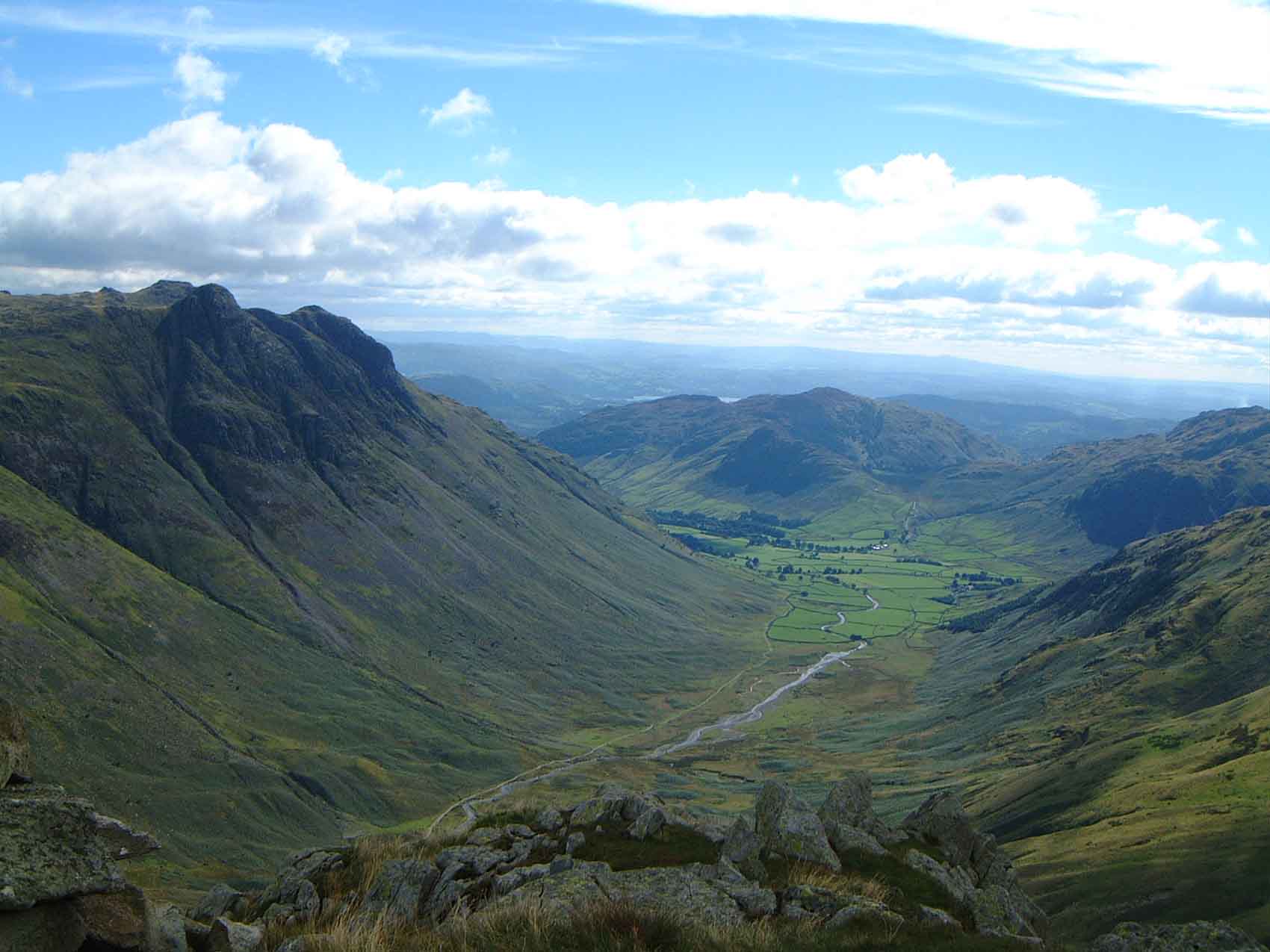
Great Langdale is a valley in the Lake District National Park in North West England, the epithet "Great" distinguishing it from the neighbouring valley of Little Langdale. Langdale is also the name of a valley in the Howgill Fells, elsewhere in Cumbria. The name is likely Norse, translating to "Long Valley".
It is a popular location for hikers, climbers, fell-runners and other outdoor enthusiasts who are attracted by the many fells ringing the head of the valley. Among the best-known features of Great Langdale are the Langdale Pikes, a group of peaks on the northern side of the dale. England's highest mountain, Scafell Pike, can be climbed by a route from Langdale. Langdale has views of, in particular, Dungeon Ghyll Force waterfall, Harrison Stickle and Pike of Stickle.
Great Langdale was an important site during the Neolithic period for producing stone axes and, later, was also one of the centres of the Lakeland slate industry.
Great Langdale had a productive stone axe industry during the Neolithic period. The area has outcrops of fine-grained greenstone suitable for making polished axes which have been found distributed across the British Isles. The rock is an epidotised greenstone quarried, or perhaps just collected, from the scree slopes in the Langdale Valley on Harrison Stickle and Pike of Stickle.
Great Langdale is known to archaeologists as the source of a particular type of Neolithic polished stone axe head - or "Group VI axes" - whose stone was collected on the slopes of the Pike of Stickle and traded all over prehistoric Great Britain and Europe. These axes have been found as far south as the River Thames and Cornwall, and as far north as Orkney, but are particularly prevalent in East Riding and the Rudston Landscape.
The Langdale Boulders at Copt Howe preserve England’s largest and most complex assemblage of Neolithic rock carvings, dated to c. 3300–2900 BC and rediscovered in 1999, consisting of incised linear and ring-like motifs. Stylistically, the carvings show strong affinities with Irish passage tomb art - such as that at Newgrange - suggesting long-distance cultural connections into Great Langdale, facilitated by Neolithic exchange networks. Although later quarrying damaged part of the boulders, the site remains significant as evidence of ceremonial activity and as part of a broader regional transition in the later Neolithic, when the decline of the Langdale axe industry coincided with the emergence of large megalithic monuments across Cumbria, possibly reflecting wider Irish Sea cultural influences.
Taken together, evidence positions Great Langdale as a central node in Early Neolithic Britain: a place of production, exchange, and likely ritual significance. Its influence may have extended well beyond Northern England, contributing materially and symbolically to the emergence of Neolithic monument traditions across the region - particularly the Stone Circle and Henge.
The mouth of the valley is located at Skelwith Bridge, which lies about two miles (three kilometres) west of Ambleside. The Langdale valley contains two villages, Chapel Stile and Elterwater, and a hamlet at High Close. Great Langdale is a U-shaped valley formed by glaciers, while Little Langdale is a hanging valley.
Hub AI
Great Langdale AI simulator
(@Great Langdale_simulator)
Great Langdale
Great Langdale is a valley in the Lake District National Park in North West England, the epithet "Great" distinguishing it from the neighbouring valley of Little Langdale. Langdale is also the name of a valley in the Howgill Fells, elsewhere in Cumbria. The name is likely Norse, translating to "Long Valley".
It is a popular location for hikers, climbers, fell-runners and other outdoor enthusiasts who are attracted by the many fells ringing the head of the valley. Among the best-known features of Great Langdale are the Langdale Pikes, a group of peaks on the northern side of the dale. England's highest mountain, Scafell Pike, can be climbed by a route from Langdale. Langdale has views of, in particular, Dungeon Ghyll Force waterfall, Harrison Stickle and Pike of Stickle.
Great Langdale was an important site during the Neolithic period for producing stone axes and, later, was also one of the centres of the Lakeland slate industry.
Great Langdale had a productive stone axe industry during the Neolithic period. The area has outcrops of fine-grained greenstone suitable for making polished axes which have been found distributed across the British Isles. The rock is an epidotised greenstone quarried, or perhaps just collected, from the scree slopes in the Langdale Valley on Harrison Stickle and Pike of Stickle.
Great Langdale is known to archaeologists as the source of a particular type of Neolithic polished stone axe head - or "Group VI axes" - whose stone was collected on the slopes of the Pike of Stickle and traded all over prehistoric Great Britain and Europe. These axes have been found as far south as the River Thames and Cornwall, and as far north as Orkney, but are particularly prevalent in East Riding and the Rudston Landscape.
The Langdale Boulders at Copt Howe preserve England’s largest and most complex assemblage of Neolithic rock carvings, dated to c. 3300–2900 BC and rediscovered in 1999, consisting of incised linear and ring-like motifs. Stylistically, the carvings show strong affinities with Irish passage tomb art - such as that at Newgrange - suggesting long-distance cultural connections into Great Langdale, facilitated by Neolithic exchange networks. Although later quarrying damaged part of the boulders, the site remains significant as evidence of ceremonial activity and as part of a broader regional transition in the later Neolithic, when the decline of the Langdale axe industry coincided with the emergence of large megalithic monuments across Cumbria, possibly reflecting wider Irish Sea cultural influences.
Taken together, evidence positions Great Langdale as a central node in Early Neolithic Britain: a place of production, exchange, and likely ritual significance. Its influence may have extended well beyond Northern England, contributing materially and symbolically to the emergence of Neolithic monument traditions across the region - particularly the Stone Circle and Henge.
The mouth of the valley is located at Skelwith Bridge, which lies about two miles (three kilometres) west of Ambleside. The Langdale valley contains two villages, Chapel Stile and Elterwater, and a hamlet at High Close. Great Langdale is a U-shaped valley formed by glaciers, while Little Langdale is a hanging valley.
Recent media