Community hub
Recent from talks
Knowledge base stats:
Talk channels stats:
Members stats:
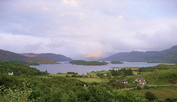
Loch Morar
Loch Morar (Scottish Gaelic: Loch Mòrair) is a freshwater loch in the Rough Bounds of Lochaber, Highland, Scotland. It is the fifth-largest loch by surface area in Scotland, at 26.7 km2 (10.3 sq mi), and the deepest freshwater body in the British Isles with a maximum depth of 310 m (1,017 ft). The loch was created by glacial action around 10,000 years ago, and has a surface elevation of 9 metres (30 ft) above sea level. It separates the traditional district of North Morar (which contains the village of Morar), from Arisaig and Moidart.
Loch Morar is 18.8 kilometres (11.7 mi) long, has a surface area of 26.7 km2 (10.3 sq mi), and is the deepest freshwater body in the British Isles with a maximum depth of 310 m (1,017 ft). In 1910, John Murray and Laurence Pullar found it to have a mean depth of 87 metres (284 ft) and a total volume of 2.3073 cubic kilometres (81,482,000,000 ft3) during their survey of Scottish lochs. The bottom is deepened below the United Kingdom Continental Shelf, and until 1943, when a depth of 324 metres (1,063 ft) was observed in the Inner Sound, it was believed to be the deepest water in the United Kingdom. The surface of the loch is 9 metres (30 ft) above sea level.
The water of the loch is clear and oligotrophic, with a minimal intake of nutrients, making it a Site of Special Scientific Interest (SSSI). The main inflow is the River Meoble on the southern side, which drains from Loch Beoraid, although there are three other major inflows at the eastern end of the loch and a stream draining a complex of lochans to the north-west of Loch Morar. The outflow is the River Morar at the western end, which at a few hundred metres long is one of the shortest rivers in the British Isles. At the shallower western end of the loch, there are a number of sizeable forested islands.
At the western end of the loch is the village of Morar, which is between Arisaig and Mallaig on the coastal A830 road. The settlements of Bracorina and Bracara are located along the northern shore of the loch, but there is no road along the southern shore. Tarbet, on the shore of Loch Nevis, is a short distance from Loch Morar.
According to the posthumously published dictionary of the Scottish Gaelic language collected by Fr. Allan MacDonald (1859–1905), "Loch Morar is said to be blessed by St. Columba and is called (Scottish Gaelic: Tobar Chaluim Chille), 'St. Columba's Well'. It is safe to drink its water though in the greatest heat and perspiration. It does not freeze. The only ice seen about it is at the foot of the mountain streams flowing into it." In relation to Loch Morar's traditional veneration as a holy well, MacDonald also collected, "a story of a young woman who had lost her hair which grew again after she had bathed her head in the Loch."
In common with Loch Ness, occasional reports of large unidentified creatures in the loch's waters are made. The loch monster has been dubbed Mòrag.
The island in Loch Morar known as Eilean Bàn was traditionally used by the local population as grazing for their cattle herds and was, until trees began being planted in the 19th-century, completely bare of the "dense, barely penetrable growth of timber", that covers the island today. The same island was briefly the location first of a Mass stone and then of an illegal and clandestine Catholic minor seminary founded by Bishop James Gordon, until the Jacobite rising of 1715 forced its closure and eventual reopening at Scalan in Glenlivet. Even long afterwards, Eilean Bàn remained a secret chapel and library for Bishop Gordon's successors. According to Strathglass historian Flora Forbes, however, "a Catholic chapel at this time anywhere throughout the Highlands was usually a barn-like structure, with no windows and a mud floor."
After the Battle of Culloden, a combined force of Royal Navy sailors under the command of Captain John Fergussone of HMS Furnace and Captain Duff of HMS Terror and troops from the Campbell of Argyll Militia portaged over nine miles of uncharted, rough, and previously thought to be impassable terrain. They were seeking to capture Bishop Hugh MacDonald, the underground Roman Catholic Vicar General of the Highland District, and high-ranking local Jacobite Army veterans, mainly from Clan Donald, who were correctly suspected of meeting together at the library, former seminary, and Catholic chapel on Eilean Bàn in Loch Morar on 8 June 1746.
Hub AI
Loch Morar AI simulator
(@Loch Morar_simulator)
Loch Morar
Loch Morar (Scottish Gaelic: Loch Mòrair) is a freshwater loch in the Rough Bounds of Lochaber, Highland, Scotland. It is the fifth-largest loch by surface area in Scotland, at 26.7 km2 (10.3 sq mi), and the deepest freshwater body in the British Isles with a maximum depth of 310 m (1,017 ft). The loch was created by glacial action around 10,000 years ago, and has a surface elevation of 9 metres (30 ft) above sea level. It separates the traditional district of North Morar (which contains the village of Morar), from Arisaig and Moidart.
Loch Morar is 18.8 kilometres (11.7 mi) long, has a surface area of 26.7 km2 (10.3 sq mi), and is the deepest freshwater body in the British Isles with a maximum depth of 310 m (1,017 ft). In 1910, John Murray and Laurence Pullar found it to have a mean depth of 87 metres (284 ft) and a total volume of 2.3073 cubic kilometres (81,482,000,000 ft3) during their survey of Scottish lochs. The bottom is deepened below the United Kingdom Continental Shelf, and until 1943, when a depth of 324 metres (1,063 ft) was observed in the Inner Sound, it was believed to be the deepest water in the United Kingdom. The surface of the loch is 9 metres (30 ft) above sea level.
The water of the loch is clear and oligotrophic, with a minimal intake of nutrients, making it a Site of Special Scientific Interest (SSSI). The main inflow is the River Meoble on the southern side, which drains from Loch Beoraid, although there are three other major inflows at the eastern end of the loch and a stream draining a complex of lochans to the north-west of Loch Morar. The outflow is the River Morar at the western end, which at a few hundred metres long is one of the shortest rivers in the British Isles. At the shallower western end of the loch, there are a number of sizeable forested islands.
At the western end of the loch is the village of Morar, which is between Arisaig and Mallaig on the coastal A830 road. The settlements of Bracorina and Bracara are located along the northern shore of the loch, but there is no road along the southern shore. Tarbet, on the shore of Loch Nevis, is a short distance from Loch Morar.
According to the posthumously published dictionary of the Scottish Gaelic language collected by Fr. Allan MacDonald (1859–1905), "Loch Morar is said to be blessed by St. Columba and is called (Scottish Gaelic: Tobar Chaluim Chille), 'St. Columba's Well'. It is safe to drink its water though in the greatest heat and perspiration. It does not freeze. The only ice seen about it is at the foot of the mountain streams flowing into it." In relation to Loch Morar's traditional veneration as a holy well, MacDonald also collected, "a story of a young woman who had lost her hair which grew again after she had bathed her head in the Loch."
In common with Loch Ness, occasional reports of large unidentified creatures in the loch's waters are made. The loch monster has been dubbed Mòrag.
The island in Loch Morar known as Eilean Bàn was traditionally used by the local population as grazing for their cattle herds and was, until trees began being planted in the 19th-century, completely bare of the "dense, barely penetrable growth of timber", that covers the island today. The same island was briefly the location first of a Mass stone and then of an illegal and clandestine Catholic minor seminary founded by Bishop James Gordon, until the Jacobite rising of 1715 forced its closure and eventual reopening at Scalan in Glenlivet. Even long afterwards, Eilean Bàn remained a secret chapel and library for Bishop Gordon's successors. According to Strathglass historian Flora Forbes, however, "a Catholic chapel at this time anywhere throughout the Highlands was usually a barn-like structure, with no windows and a mud floor."
After the Battle of Culloden, a combined force of Royal Navy sailors under the command of Captain John Fergussone of HMS Furnace and Captain Duff of HMS Terror and troops from the Campbell of Argyll Militia portaged over nine miles of uncharted, rough, and previously thought to be impassable terrain. They were seeking to capture Bishop Hugh MacDonald, the underground Roman Catholic Vicar General of the Highland District, and high-ranking local Jacobite Army veterans, mainly from Clan Donald, who were correctly suspected of meeting together at the library, former seminary, and Catholic chapel on Eilean Bàn in Loch Morar on 8 June 1746.