
Community hub
Recent from talks
Contribute something
Nothing was collected or created yet.
Macanal
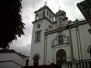
View on WikipediaMacanal is a town and municipality in the Colombian Department of Boyacá, part of the subregion of the Neira Province. The urban centre is located in the Tenza Valley in the Eastern Ranges of the Colombian Andes at an elevation of 1,680.3 metres (5,513 ft) but parts of the municipality reach elevations of 2,500 metres (8,200 ft). It borders Campohermoso in the east, Almeida in the west, Garagoa in the north and in the south Santa María and Chivor.[1]
Key Information

.svg)

Etymology
[edit]The name Macanal is either derived from the Chibcha word Macana, meaning garrote, or from the Macana palm tree (Wettinia kalbreyeri).[1][2]
History
[edit]The area of Macanal was part of the Muisca Confederation, a loose confederation of different rulers of the Muisca. The zaque of Hunza ruled over Macanal.
Modern Macanal was founded on May 4, 1807.[1]
Tourism
[edit]Macanal, is known for its natural beauty, eco-tourism, and outdoor activities.[3] Key attractions include the Chivor Reservoir, popular for kayaking, fishing, and kite surfing, as well as nearby waterfalls and hiking trails. The area is a haven for birdwatching, with diverse native and migratory species.[4] Visitors can also enjoy rural tourism and local festivals that celebrate the region's culture. With its tranquil environment and focus on sustainable travel, Macanal offers a unique escape for nature and adventure enthusiasts.
Festivals
[edit]The Reinado del Agua in Macanal, Boyaca, is a cultural and tourist event that celebrates the municipality's water resources, highlighting its connection with the Chivor Reservoir. This event features parades, folk performances, sports activities, and musical events, with a focus on environmental awareness and promoting water conservation. Additionally, it includes typical gastronomy and handicrafts, strengthening cultural identity and attracting sustainable tourism.[5]
Geology
[edit]The Macanal Formation, an organic shale, outcrops near and has been named after Macanal.
Economy
[edit]Main economical activities of Macanal are agriculture; coffee (Coffea arabica), bananas, maize, beans (Phaseolus vulgaris), yuca, sugarcane (Saccharum officinarum), arracacha (Arracacia xanthorrhiza), avocadoes, papayas, mangoes, guayaba and cucumbers (Cucumis sativus and Cyclanthera pedata), livestock farming and mining (gypsum and emeralds).[1]
Climate
[edit]| Climate data for Macanal (Inst Agr Macanal), elevation 1,300 m (4,300 ft), (1981–2010) | |||||||||||||
|---|---|---|---|---|---|---|---|---|---|---|---|---|---|
| Month | Jan | Feb | Mar | Apr | May | Jun | Jul | Aug | Sep | Oct | Nov | Dec | Year |
| Mean daily maximum °C (°F) | 23.5 (74.3) |
24.1 (75.4) |
23.5 (74.3) |
22.6 (72.7) |
21.9 (71.4) |
21.0 (69.8) |
20.5 (68.9) |
21.1 (70.0) |
22.1 (71.8) |
22.7 (72.9) |
22.3 (72.1) |
22.7 (72.9) |
22.2 (72.0) |
| Daily mean °C (°F) | 17.5 (63.5) |
17.8 (64.0) |
17.9 (64.2) |
17.7 (63.9) |
17.3 (63.1) |
16.6 (61.9) |
16.2 (61.2) |
16.4 (61.5) |
16.9 (62.4) |
17.4 (63.3) |
17.6 (63.7) |
17.4 (63.3) |
17.2 (63.0) |
| Mean daily minimum °C (°F) | 12.9 (55.2) |
13.4 (56.1) |
14.1 (57.4) |
14.6 (58.3) |
14.4 (57.9) |
13.9 (57.0) |
13.3 (55.9) |
13.3 (55.9) |
13.3 (55.9) |
13.6 (56.5) |
14.1 (57.4) |
13.5 (56.3) |
13.7 (56.7) |
| Average precipitation mm (inches) | 26.6 (1.05) |
64.2 (2.53) |
101.5 (4.00) |
191.5 (7.54) |
322.9 (12.71) |
367.9 (14.48) |
353.7 (13.93) |
293.6 (11.56) |
204.8 (8.06) |
160.4 (6.31) |
104.5 (4.11) |
48.5 (1.91) |
2,206.3 (86.86) |
| Average precipitation days (≥ 1.0 mm) | 9 | 11 | 16 | 24 | 27 | 28 | 29 | 28 | 24 | 22 | 20 | 14 | 246 |
| Average relative humidity (%) | 84 | 83 | 85 | 88 | 90 | 91 | 92 | 90 | 88 | 88 | 88 | 87 | 88 |
| Mean monthly sunshine hours | 182.9 | 144.0 | 120.9 | 96.0 | 96.1 | 81.0 | 86.8 | 93.0 | 120.0 | 142.6 | 144.0 | 173.6 | 1,480.9 |
| Mean daily sunshine hours | 5.9 | 5.1 | 3.9 | 3.2 | 3.1 | 2.7 | 2.8 | 3.0 | 4.0 | 4.6 | 4.8 | 5.6 | 4.1 |
| Source: Instituto de Hidrologia Meteorologia y Estudios Ambientales[6] | |||||||||||||
Gallery
[edit]-
 House in Macanal
 -
 Landscape around Macanal
 -
 Artificial lake near Macanal


References
[edit]- ^ a b c d (in Spanish) Official website Macanal
- ^ (in Spanish) Etymology Municipalities Boyacá - Excelsio.net
- ^ RCN, Noticias (2024-11-01). "El pueblo cerca de Bogotá con un atractivo al estilo Hollywood para visitar este puente festivo". Noticias RCN (in Spanish). Retrieved 2024-12-12.
- ^ "Catálogo de aves". Reserva Macanal (in Spanish). Retrieved 2024-12-12.
- ^ Tiempo, Redacción El (1998-12-01). "EN MACANAL, PRIMER FESTIVAL DEL AGUA". El Tiempo (in Spanish). Retrieved 2024-12-10.
- ^ "Promedios Climatológicos 1981–2010" (in Spanish). Instituto de Hidrologia Meteorologia y Estudios Ambientales. Archived from the original on 15 August 2016. Retrieved 3 June 2024.
| Gold |  | |
|---|---|---|
| Silver | ||
| Platinum | ||
| Nickel | ||
| Coltan | ||
| Emeralds | ||
| Coal | ||
| Salt | ||
| Sources | ||
| Geology |  | ||||
|---|---|---|---|---|---|
| History |
| ||||
| Main mining areas |
| ||||
| Individual mines | |||||
| Individual emeralds (ct) |
| ||||
| Related articles | |||||