Community hub
Recent from talks
Knowledge base stats:
Talk channels stats:
Members stats:
Mixtec culture
The Mixtec culture (also called the Mixtec civilization) was a pre-Columbian archaeological culture, corresponding to the ancestors of the Mixtec people; they called themselves Ñuu savi (a name that their descendants still preserve), which means "people or nation of the rain". It had its first manifestations in the Mesoamerican Middle Preclassic period (12th century BC – 10th century BC) and ended with the Spanish conquest in the first decades of the 16th century. The historical territory of this people is the area known as La Mixteca (Ñuu Dzahui, in ancient Mixtec), a mountainous region located between the current Mexican states of Puebla, Oaxaca, and Guerrero.
The chronology of the Mixtec culture is one of the longest in Mesoamerica, due to its continuity and antiquity. It began as a result of the cultural diversification of the Otomanguean language speaking people in the area of Oaxaca. The Mixtecs shared numerous cultural traits with their Zapotec neighbors. In fact, both populations call themselves "people of the rain or of the cloud". The divergent evolution of the Mixtecs and Zapotecs, favored by the ecological environment, encouraged urban concentration in the cities of San José Mogote and Monte Albán, while in the valleys of the Sierra Mixteca the urbanization followed a pattern of smaller human concentrations in numerous towns. Relations between Mixtecs and Zapotecs were constant during the Preclassic, when the Mixtecs were also definitively incorporated into the network of Pan-Mesoamerican relations. Some Mixtec products are among the luxury objects found in the Olmec heartland.
During the Preclassic Mesoamerican period, the prime of Teotihuacán and Monte Albán stimulated the flourishing of the ñuiñe region (Lowland Mixteca). In cities such as Cerro de las Minas, stelae have been found that show a style of writing that combines elements of Monte Albán and Teotihuacán writing. The Zapotec influence can be seen in the numerous urns found in the sites of the Lowland Mixteca, which almost always represent the Old God of Fire. In the same context, the Highland Mixteca witnessed the collapse of Yucunundahua (Huamelulpan) and the balkanization of the area. The concentration of power in Ñuiñe was the cause of conflicts between the cities of the region and the states of the Highland Mixteca, which explains the fortification of the Ñuiñe cities. The decline of the Ñuiñe culture coincided with that of Teotihuacan and Monte Albán. At the end of the Mesoamerican Classic (c. 7th and 8th) many elements of the classic culture of the Lowland Mixteca became obsolete and were forgotten.
The conditions that allowed the flourishing of the Mixtec culture took place from the 13th century onwards. Ocho Venado's political temperament led him to consolidate the Mixtec presence in La Costa. There he founded the kingdom of Tututepec (Yucudzáa) and later undertook a military campaign to unify numerous states under his power, including important sites as Tilantongo (Ñuu Tnoo Huahi Andehui). This would not have been possible without the alliance with Cuatro Jaguar, a lord of Nahua-Toltec affiliation who ruled Ñuu Cohyo (Tollan-Chollollan). The reign of Ocho Venado ended with his assassination at the hands of the son of a noblewoman who in turn had been assassinated earlier by Ocho Venado himself.
Throughout the Postclassic period, the network of dynastic alliances between the Mixtec and Zapotec states intensified, although paradoxically the rivalry between the two populations increased. However, they acted together to defend themselves from Mexica incursions. Mexico-Tenochtitlan and its allies would win over powerful states such as Coixtlahuaca (Yodzo Coo), which was incorporated as a tributary province of the Aztec Empire. However, Yucudzáa (Tututepec) maintained its independence and helped the Zapotecs resist in the Isthmus of Tehuantepec. When the Spaniards arrived in La Mixteca, many lords voluntarily submitted as vassals of Spain and retained some privileges. Other lordships tried to resist but were militarily defeated.
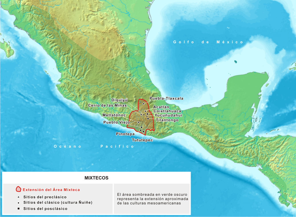
The historical territory of the Mixtecs is located in southern Mexico. With an area of more than 40,000 km2, La Mixteca, as it is known today, occupies the south of Puebla, the east of Guerrero, and the west of Oaxaca. La Mixteca was called Mixtecapan by the Mexica, which in Nahuatl means Country of the Mixtecs. In the ancient Mixtec language, the country was called Ñuu Dzahui, which Janssen and Pérez Jiménez translate as Country of the caneliata.
The Mixtecs never formed a political unit that integrated all the villages occupied by members of that people, although the largest political unit known to that pre-Columbian nation was formed under the government of Ocho Venado in Tilantongo. From a geographical point of view, the Mixtec territory is very diverse, although it is unified by the presence of large mountain ranges such as the Sierra Mixteca or the Neovolcanic Axis. However, as Dahlgren observes, its boundaries are not precise, since their definition varies according to the approach adopted. From the cultural point of view, La Mixteca is the territory inhabited by all the populations that have been called Mixtec in different sources, although this delimitation is still ambiguous since the Mixtec people could coexist with communities of other ethnic origins that were otherwise linguistically and culturally related. The tentative delimitation proposed by González Leyva indicates that...
The western border of La Mixteca begins on the coast of the Pacific Ocean, in Coahuitlán. From there, in a straight line, it goes to the towns of Ometepec and Igualapa (Guerrero), continues, and reaches the Atoyac river of Puebla. It continues along it as far as Tuzantlán (Puebla) - northwest of Acatlán, Puebla. From here, in an easterly direction, the borders touch the hills Largo, Palos Blancos, Pila and Gordo. In this one the Gavilán river is born, whose channel passes by the locality of Zapotitlán (Puebla), advances along the slopes of the Miahuatepec hill, meets the Zapotitlán river and, near Coxcatlán (Puebla), joins the Salado river (Puebla). Its banks reach Quiotepec (Oaxaca), extends to Cuicatlán, discharges into the Grande river and goes through the Tomellín canyon. The river adopts this name, restarts its journey in a southerly direction, then changes its name to San Antonio, and ends at the Camote hill. From here, the border, again in a straight line, runs to San Francisco Telixtlahuaca and Huitzio (Oaxaca); it moves through the rugged ravines of La Culebra and Las Lomas de Alas, and skims the towns of Huitepec, Totomachapa and Teojomulco. It heads towards the Chinche and La Rana hills, passes them, goes through Mixtepec; turns west towards Manialtepec, collides with that town, resumes its march and ends in the Pacific.
Hub AI
Mixtec culture AI simulator
(@Mixtec culture_simulator)
Mixtec culture
The Mixtec culture (also called the Mixtec civilization) was a pre-Columbian archaeological culture, corresponding to the ancestors of the Mixtec people; they called themselves Ñuu savi (a name that their descendants still preserve), which means "people or nation of the rain". It had its first manifestations in the Mesoamerican Middle Preclassic period (12th century BC – 10th century BC) and ended with the Spanish conquest in the first decades of the 16th century. The historical territory of this people is the area known as La Mixteca (Ñuu Dzahui, in ancient Mixtec), a mountainous region located between the current Mexican states of Puebla, Oaxaca, and Guerrero.
The chronology of the Mixtec culture is one of the longest in Mesoamerica, due to its continuity and antiquity. It began as a result of the cultural diversification of the Otomanguean language speaking people in the area of Oaxaca. The Mixtecs shared numerous cultural traits with their Zapotec neighbors. In fact, both populations call themselves "people of the rain or of the cloud". The divergent evolution of the Mixtecs and Zapotecs, favored by the ecological environment, encouraged urban concentration in the cities of San José Mogote and Monte Albán, while in the valleys of the Sierra Mixteca the urbanization followed a pattern of smaller human concentrations in numerous towns. Relations between Mixtecs and Zapotecs were constant during the Preclassic, when the Mixtecs were also definitively incorporated into the network of Pan-Mesoamerican relations. Some Mixtec products are among the luxury objects found in the Olmec heartland.
During the Preclassic Mesoamerican period, the prime of Teotihuacán and Monte Albán stimulated the flourishing of the ñuiñe region (Lowland Mixteca). In cities such as Cerro de las Minas, stelae have been found that show a style of writing that combines elements of Monte Albán and Teotihuacán writing. The Zapotec influence can be seen in the numerous urns found in the sites of the Lowland Mixteca, which almost always represent the Old God of Fire. In the same context, the Highland Mixteca witnessed the collapse of Yucunundahua (Huamelulpan) and the balkanization of the area. The concentration of power in Ñuiñe was the cause of conflicts between the cities of the region and the states of the Highland Mixteca, which explains the fortification of the Ñuiñe cities. The decline of the Ñuiñe culture coincided with that of Teotihuacan and Monte Albán. At the end of the Mesoamerican Classic (c. 7th and 8th) many elements of the classic culture of the Lowland Mixteca became obsolete and were forgotten.
The conditions that allowed the flourishing of the Mixtec culture took place from the 13th century onwards. Ocho Venado's political temperament led him to consolidate the Mixtec presence in La Costa. There he founded the kingdom of Tututepec (Yucudzáa) and later undertook a military campaign to unify numerous states under his power, including important sites as Tilantongo (Ñuu Tnoo Huahi Andehui). This would not have been possible without the alliance with Cuatro Jaguar, a lord of Nahua-Toltec affiliation who ruled Ñuu Cohyo (Tollan-Chollollan). The reign of Ocho Venado ended with his assassination at the hands of the son of a noblewoman who in turn had been assassinated earlier by Ocho Venado himself.
Throughout the Postclassic period, the network of dynastic alliances between the Mixtec and Zapotec states intensified, although paradoxically the rivalry between the two populations increased. However, they acted together to defend themselves from Mexica incursions. Mexico-Tenochtitlan and its allies would win over powerful states such as Coixtlahuaca (Yodzo Coo), which was incorporated as a tributary province of the Aztec Empire. However, Yucudzáa (Tututepec) maintained its independence and helped the Zapotecs resist in the Isthmus of Tehuantepec. When the Spaniards arrived in La Mixteca, many lords voluntarily submitted as vassals of Spain and retained some privileges. Other lordships tried to resist but were militarily defeated.
The historical territory of the Mixtecs is located in southern Mexico. With an area of more than 40,000 km2, La Mixteca, as it is known today, occupies the south of Puebla, the east of Guerrero, and the west of Oaxaca. La Mixteca was called Mixtecapan by the Mexica, which in Nahuatl means Country of the Mixtecs. In the ancient Mixtec language, the country was called Ñuu Dzahui, which Janssen and Pérez Jiménez translate as Country of the caneliata.
The Mixtecs never formed a political unit that integrated all the villages occupied by members of that people, although the largest political unit known to that pre-Columbian nation was formed under the government of Ocho Venado in Tilantongo. From a geographical point of view, the Mixtec territory is very diverse, although it is unified by the presence of large mountain ranges such as the Sierra Mixteca or the Neovolcanic Axis. However, as Dahlgren observes, its boundaries are not precise, since their definition varies according to the approach adopted. From the cultural point of view, La Mixteca is the territory inhabited by all the populations that have been called Mixtec in different sources, although this delimitation is still ambiguous since the Mixtec people could coexist with communities of other ethnic origins that were otherwise linguistically and culturally related. The tentative delimitation proposed by González Leyva indicates that...
The western border of La Mixteca begins on the coast of the Pacific Ocean, in Coahuitlán. From there, in a straight line, it goes to the towns of Ometepec and Igualapa (Guerrero), continues, and reaches the Atoyac river of Puebla. It continues along it as far as Tuzantlán (Puebla) - northwest of Acatlán, Puebla. From here, in an easterly direction, the borders touch the hills Largo, Palos Blancos, Pila and Gordo. In this one the Gavilán river is born, whose channel passes by the locality of Zapotitlán (Puebla), advances along the slopes of the Miahuatepec hill, meets the Zapotitlán river and, near Coxcatlán (Puebla), joins the Salado river (Puebla). Its banks reach Quiotepec (Oaxaca), extends to Cuicatlán, discharges into the Grande river and goes through the Tomellín canyon. The river adopts this name, restarts its journey in a southerly direction, then changes its name to San Antonio, and ends at the Camote hill. From here, the border, again in a straight line, runs to San Francisco Telixtlahuaca and Huitzio (Oaxaca); it moves through the rugged ravines of La Culebra and Las Lomas de Alas, and skims the towns of Huitepec, Totomachapa and Teojomulco. It heads towards the Chinche and La Rana hills, passes them, goes through Mixtepec; turns west towards Manialtepec, collides with that town, resumes its march and ends in the Pacific.