

Community hub
Recent from talks
Contribute something
Nothing was collected or created yet.
Mudanya
View on WikipediaMudanya (also: Mudania;[2] Greek: τα Μουδανιά, ta Moudaniá; the site of ancient Apamea Myrlea) is a municipality and district of Bursa Province, Turkey.[3] Its area is 369 km2,[4] and its population is 108,011 (2022).[1] It is located on the Gulf of Gemlik, part of the southern coast of the Sea of Marmara. Between 1875 and 1948, it was connected with Bursa by the Mudanya–Bursa railway.[5] Mudanya has only an open anchorage usable in calm weather. The town produces olive oil and there is a pier used by local fishing and cargo boats.
Key Information


History
[edit]According to the Ottoman General Census of 1881/82-1893, the kaza of Mudanya of Hüdavendigâr vilayet had a total population of 16,683, consisting of 11,792 Greeks and 4,891 Muslims.[6] A port city, it also had a railway connection to Bursa which was completed in 1875. The railway had a pier at the seaport of Mudanya for exporting. Istanbul was often the recipient of exported goods from Mudanya. Silk was a popular export.[7] During the Turkish War of Independence, Mudanya was bombarded by the Royal Navy and thus partially burned by the British Fleet during the Greek Summer Offensive of 1920. Sergeant Şükrü from Mudanya and 9 of his brothers-in-arms were killed during the Allied bombardment and subsequent landing by the Greek troops and the British Royal Marines.[8]
.jpg)
Liberation of Mudanya
[edit]Mudanya and its environs were liberated by the Turkish Kocaeli Army Corps under the Command of Halit (Karsıalan) Paşa on the 12th of September 1922.[9] The Greek 11th Infantry Division (Manisa Division) and the 45th &17th Infantry regiments along with their commanders and with Major-General Nikolaos Kladas were captured.[10]
.jpg)

The town was the signing place of the Armistice of Mudanya between Turkey, Italy, France and Britain on October 11, 1922, following the Turkish War of Independence.
After the Treaty of Lausanne and the Greco-Turkish population exchange agreement, the Greeks of the town were transferred into mainland Greece, establishing a settlement to which they gave the name of their previous town, Nea Moudania (New Moudania, located on the Chalkidiki peninsula, in the Macedonia region of Greece). In return, a number of Cretan Turks were settled in Mudanya.
Composition
[edit]There are 47 neighbourhoods in Mudanya District:[11]
- Akköy
- Altıntaş
- Aydınpınar
- Bademli
- Balabancık
- Çağrışan
- Çamlık
- Çayönü
- Çekrice
- Çepni
- Çınarlı
- Dedeköy
- Dereköy
- Eğerce
- Emirleryenicesi
- Esence
- Evciler
- Göynüklü
- Güzelyalı Burgaz
- Güzelyalı Eğitim
- Güzelyalı Siteler
- Güzelyalı Yalı
- Halitpaşa
- Hançerli
- Hasanbey
- Hasköy
- İpekyayla
- Işıklı
- Kaymakoba
- Küçükyenice
- Kumyaka
- Mesudiye
- Mirzaoba
- Mürsel
- Mütareke
- Ömerbey
- Orhaniye
- Söğütpınar
- Şükrüçavuş
- Tirilye
- Ülkü
- Yalıçiftlik
- Yaman
- Yaylacık
- Yenimahalle
- Yörükali
- Yörükyenicesi
Traditional architecture in Mudanya
[edit]-
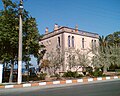
 The Armistice of Mudanya was signed in this Ottoman era building
 -
 Ottoman era Governor's House in Mudanya
 -
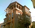
 Ottoman era traditional building in Mudanya
 -
 Ottoman era traditional house in Mudanya
 -
 Ottoman era traditional house in Mudanya
 -
 Ottoman era traditional house in Mudanya
 -
 Ottoman era traditional house in Mudanya
 -
 Ottoman era traditional house in Mudanya
 -
 Ottoman era traditional houses in Mudanya
 -
 Ottoman era traditional houses in Mudanya
 -
 Ottoman era traditional houses in Mudanya
 -
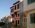 Ottoman era traditional houses in Mudanya


See also
[edit]References
[edit]- ^ a b "Address-based population registration system (ADNKS) results dated 31 December 2022, Favorite Reports" (XLS). TÜİK. Retrieved 12 July 2023.
- ^ Chisholm, Hugh, ed. (1911). . Encyclopædia Britannica. Vol. 18 (11th ed.). Cambridge University Press. p. 955.
- ^ Büyükşehir İlçe Belediyesi, Turkey Civil Administration Departments Inventory. Retrieved 12 July 2023.
- ^ "İl ve İlçe Yüz ölçümleri". General Directorate of Mapping. Retrieved 12 July 2023.
- ^ "Trains of Turkey | Main / HomePage". www.trainsofturkey.com.
- ^ Kemal Karpat (1985), Ottoman Population, 1830-1914, Demographic and Social Characteristics, The University of Wisconsin Press, p. 132-133
- ^ Prothero, G.W. (1920). Anatolia. London: H.M. Stationery Office.
- ^ "Zafer'den Kurtuluş'a… 12 Eylül 1922 Mudanya'nın Kurtuluşu". MUDANYA Gazetesi. 2022-09-11. Retrieved 2022-10-16.
- ^ "Zafer'den Kurtuluş'a… 12 Eylül 1922 Mudanya'nın Kurtuluşu". MUDANYA Gazetesi. 2022-09-11. Retrieved 2022-10-16.
- ^ Niş, Kemal; Söker, Reşat; Ercan, Tevfik; Anıt, Çetin (December 1995). Türk İstiklal Harbi II. Cilt Batı Cephesi 6. Kısım III. Kitap Büyük Taarruzda Takip Harekatı (31 Ağustos - 18 Eylül 1922) (in Turkish). Ankara, Türkiye: Genelkurmay Atase Başkanlığı Yayınları. pp. 311–312. ISBN 9789754090598.
- ^ Mahalle, Turkey Civil Administration Departments Inventory. Retrieved 12 July 2023.
External links
[edit]- District governor's official website
- District municipality's official website
- Chisholm, Hugh, ed. (1911). . Encyclopædia Britannica. Vol. 18 (11th ed.). Cambridge University Press. p. 955.
Mudanya in Bursa Province of Turkey | |||||||||||||||||||||||||||
|---|---|---|---|---|---|---|---|---|---|---|---|---|---|---|---|---|---|---|---|---|---|---|---|---|---|---|---|
| Districts |   | ||||||||||||||||||||||||||
|
Metropolitan municipalities are bolded. | |||||||||||||||||||||||||||
Mudanya
View on GrokipediaGeography
Location and physical features
Mudanya is a coastal district in Bursa Province, within Turkey's Marmara Region, positioned on the southern shore of the Sea of Marmara along the Gulf of Gemlik.[10] Its central coordinates are approximately 40.377° N latitude and 28.883° E longitude.[11] The district lies about 25 kilometers northwest of Bursa city center, serving as a key port area in the region.[12] The district encompasses an area of 369 km², featuring a mix of coastal lowlands and inland elevations that rise gradually toward surrounding hills.[13] Town elevations average around 8 meters above sea level, with the terrain characterized by sandy beaches, a prominent coastline suitable for maritime activities, and verdant landscapes supporting agriculture and tourism.[13] [14] The area's physical geography includes fertile plains adjacent to the sea, transitioning to more undulating terrain inland, influenced by proximity to the Marmara fault line, though specific seismic features are not dominant in the immediate locality.[15] Mudanya's shoreline extends as a significant natural feature, with public and resort-managed beaches providing access to the Sea of Marmara, while the hinterland supports olive groves and other Mediterranean-style vegetation typical of the Marmara coast.[3] The district's position between the sea and inland highlands contributes to its role as a transitional zone in Bursa's provincial geography.[16]Climate and environment
Mudanya features a Mediterranean climate (Köppen-Geiger classification Csa), marked by hot, dry summers and mild, wet winters with the majority of precipitation occurring from October to April.[17] Annual rainfall averages 819 mm, supporting agriculture but varying seasonally with drier conditions in summer.[17] Mean annual temperature stands at 14.6 °C, with summer highs reaching up to 30 °C (86 °F) and winter lows around 3 °C (38 °F), rarely dipping below -1 °C or exceeding 33 °C.[18] The district's coastal environment along the Sea of Marmara includes beaches, olive groves, and limited forested areas, contributing to local biodiversity such as fish stocks vital for fishing economies.[19] However, the Marmara Sea, bordering Mudanya, faces severe eutrophication from untreated sewage, industrial effluents, and agricultural runoff, exacerbating algal blooms and mucilage (sea snot) formations.[20] The 2021 mucilage crisis, triggered by nutrient overload and warming waters, caused widespread hypoxia, smothering marine life including fish and shellfish in areas like nearby Gemlik Gulf.[21][22] Persistent pollution has degraded water quality, with ongoing discharges from Istanbul and Bursa Province hotspots threatening biodiversity and coastal ecosystems; studies indicate rising chemical pollutants and reduced oxygen levels persisting into 2024-2025.[23][24] Local efforts focus on wastewater treatment upgrades, but enforcement gaps and urban expansion continue to strain the marine habitat.[25]History
Ancient foundations and early settlements
The ancient settlement at Mudanya originated as the Greek colony of Myrleia, founded in the 7th century BC by colonists from Colophon in Ionia on a broad, flat hill known today as Hisarlık, approximately 1 km southeast of the modern town center.[26] [27] This coastal location along the southern shore of the Sea of Marmara positioned it as a strategic maritime outpost within the Bithynian region of Anatolia, facilitating trade and connectivity with other Ionian settlements.[28] Archaeological evidence, including city walls on the hilltop, residential structures in northern settlement areas, and submerged port ruins, underscores Myrleia's early development as a fortified harbor town.[29] Excavations initiated after a 2012 construction discovery exposed mosaic floors and other artifacts, confirming continuous occupation from the Archaic Greek period and leading to the site's formal protection as an archaeological zone.[28] [30] The nearby Kapanca harbor, utilized from Bithynian times onward, further supported maritime activities, with historical surveys dating its infrastructure to at least the Roman era but rooted in earlier Hellenistic usage.[31] Under Bithynian kingship in the 3rd–2nd centuries BC, Myrleia was renamed Apamea Myrlea by Prusias I to honor his wife Apama, integrating it into the Hellenistic kingdom's network while retaining Greek cultural elements.[30] Pre-colonial settlements specific to the Mudanya site lack substantial documentation, distinguishing it from the broader Bursa plain's Chalcolithic (ca. 5000–3000 BC) and Early Bronze Age (ca. 3000–2000 BC) traces, which indicate sporadic prehistoric activity in the region but not direct continuity with the urban foundation at Myrleia.[32]Byzantine and Ottoman periods
During the Byzantine period, Mudanya, known anciently as Apamea Myrlea, functioned as a coastal settlement in the province of Bithynia, maintaining its role as a minor port on the Sea of Marmara.[27] The surrounding region emerged as a significant center of Orthodox Christianity, particularly during the 8th and 9th centuries, with Mudanya hosting Greek communities that preserved religious and cultural traditions amid Byzantine imperial administration.[33] Archaeological evidence and historical records indicate continuity from Roman times, though the town remained secondary to larger centers like Nicaea, serving primarily for local trade and maritime connections without major fortifications or events documented in primary Byzantine sources. The transition to Ottoman rule occurred in 1321, when Orhan Gazi captured Mudanya as part of the early Ottoman expansion into Bithynia, shortly before the conquest of Bursa in 1326.[6] Integrated into the nascent Ottoman state, the town lost some prominence initially, with nearby Kurşunlu supplanting it as Bursa's primary port, but it later regained importance as a maritime outlet for regional commerce, including silk and agricultural goods from inland Bursa.[6] Under Ottoman governance, Mudanya developed characteristic wooden architecture, with multi-story houses featuring overhanging upper levels and narrow streets, reflecting Anatolian influences adapted to the coastal environment; many such structures from the 18th and 19th centuries survive today.[34] The population during the Ottoman era consisted predominantly of Greeks until the early 20th century, comprising the majority in the 19th century, alongside Muslim Turks, with the town serving as a mixed-ethnic port facilitating trade between the Ottoman interior and European markets. Ottoman administrative records, including court sicils from 1645 onward, document urban development, legal disputes, and economic activities centered on shipping and fisheries, underscoring Mudanya's steady, if unremarkable, growth as a peripheral Ottoman township until the late 19th century.[35] By the 1881/82–1893 Ottoman census, the kaza of Mudanya recorded a population of 16,683, reflecting modest demographic stability amid broader imperial declines.[36]Turkish War of Independence and Armistice of Mudanya
Following the Armistice of Mudros on October 30, 1918, which concluded Ottoman participation in World War I, Allied forces occupied key coastal areas in Anatolia, including Mudanya. Initially held by British troops, control of the town transitioned to Greek forces as part of the broader occupation and partition of Ottoman territories under the Treaty of Sèvres, signed on August 10, 1920. Greek administration in Mudanya lasted over two years, during which the town served as a logistical base amid the Greco-Turkish War (1919–1922).[6] Turkish National Movement forces, advancing after decisive victories in western Anatolia, liberated Mudanya in early September 1922. The Kocaeli Army Corps, commanded by Halit Karsıalan Pasha, secured the town and surrounding areas from Greek occupation around September 12, 1922, as part of the broader Turkish counteroffensive following the Great Offensive launched on August 26, 1922, and the recapture of İzmir on September 9, 1922. This liberation marked a critical step in reclaiming Marmara Region territories, positioning Turkish troops near the neutral Straits zone and prompting Allied calls for negotiations to avert further escalation toward Constantinople.[6][7] The Armistice of Mudanya negotiations convened in Mudanya from October 3 to 11, 1922, hosted in an Ottoman-era building to address the status of Eastern Thrace and the Straits amid Turkish military momentum. The Turkish delegation, led by İsmet Pasha (later İsmet İnönü), represented the Grand National Assembly of Turkey, facing representatives from Britain, France, and Italy—primarily naval officers enforcing the neutral zone. Tensions peaked as Turkish forces approached Çanakkale, with Britain reinforcing positions, but French and Italian mediation favored compromise to avoid renewed conflict. Greece, not initially present, acceded to the terms on October 13, 1922.[7] The armistice, signed on October 11, 1922, granted Turkey sovereignty over Eastern Thrace up to the Maritsa River, mandated the withdrawal of Greek forces westward, and required Allied evacuation of Constantinople and Eastern Thrace within a month, effectively ending active hostilities in the Turkish War of Independence. Unlike the punitive Sèvres Treaty, the Mudanya agreement recognized Turkish control without imposing demilitarization on Thrace, reflecting the shift in power dynamics after Turkish battlefield successes. It facilitated the Grand National Assembly's abolition of the Ottoman Sultanate on November 1, 1922, and set the stage for the Treaty of Lausanne in 1923, which formalized Turkey's modern borders.[7]Post-independence developments
Following the Armistice of Mudanya on 11 October 1922 and the establishment of the Republic of Turkey on 29 October 1923, the town was integrated into the republican administrative structure as a district (ilçe) within Bursa Province, with Turkish sovereignty firmly established over the region.[6] The 1923 Convention Concerning the Exchange of Greek and Turkish Populations, implemented under the Treaty of Lausanne, profoundly reshaped Mudanya's demographics. The town, previously home to a significant Greek Orthodox community engaged in trade and fishing, saw the departure of these residents, with over 1.6 million people displaced across both countries to create more homogeneous nation-states; in Bursa Province alone, more than 30,000 Muslim migrants from Greece were resettled, including in coastal areas like Mudanya, facilitating economic and cultural nationalization.[37][38] Throughout the 20th century, Mudanya's economy evolved from reliance on agriculture, olive production, and its historic role as a silk export port to a service-dominated model, with industry comprising 42% and services 54% of activity by 1990. The district's harbor supported regional trade and exports tied to Bursa's industrialization, while tourism emerged as a key sector from the 1970s, driven by secondary housing developments and its Marmara coastline appeal.[39] Demographic expansion was rapid, with population rising 44% from 1950 to 1990—exceeding Turkey's 24.75% national growth—fueled by an influx of working-age migrants (predominantly aged 35–40) and urbanization, shifting the urban share from 24.8% to 41.1%. This growth, however, imposed strains: agricultural lands and olive yards were converted for housing and infrastructure, coastal areas filled for harbors and promenades, and environmental issues like water pollution intensified, transforming Mudanya from a serene resort into a dormitory satellite of industrial Bursa and eroding its distinct livability.[39]Demographics
Population statistics
As of 31 December 2024, Mudanya district had a total population of 110,797 according to Turkey's Address Based Population Registration System data from the Turkish Statistical Institute (TÜİK).[40] This figure reflects a 7.5 per mille annual growth rate from the previous year.[40] The district's population was composed of 53,711 males (48.48%) and 57,086 females (51.52%).[40] The population has shown steady increase in recent years, driven by migration to coastal areas and urban development in Bursa Province. From 102,523 residents in 2020, it rose to approximately 108,011 by 2022 before reaching the 2024 total.[5] [40]| Year | Population |
|---|---|
| 2020 | 102,523 |
| 2022 | 108,011 |
| 2024 | 110,797 |
Ethnic and religious composition
Mudanya's ethnic and religious composition has undergone significant transformation due to historical events, particularly the 1923 population exchange between Greece and Turkey. In the late Ottoman period, the area featured a diverse demographic: the 1893 Ottoman census recorded a total population of 16,683, with Greeks comprising 71% (11,757 individuals) and Turks 29% (4,926). [5] These Greeks were predominantly Orthodox Christians, reflecting the region's Byzantine heritage and maritime ties. Nearby villages like Tirilye were similarly Greek-majority until the early 20th century. [12] The Greco-Turkish War (1919–1922) and subsequent Lausanne Convention mandated the compulsory exchange of populations, relocating approximately 1.2 million Greek Orthodox from Turkey to Greece and 400,000 Muslims from Greece to Turkey. [41] In Mudanya, this resulted in the departure of the Greek community, replaced by ethnic Turkish Muslims, primarily from Macedonia and Thrace. Post-exchange, the district's inhabitants became homogeneously ethnic Turkish, with no significant Greek or other non-Muslim remnants. [5] Today, Mudanya's population of approximately 110,797 (as of recent Turkish Statistical Institute data) is overwhelmingly ethnic Turkish and Sunni Muslim, aligning with national patterns where over 99% of Turkey's residents identify as Muslim. [42] [43] Official censuses do not track ethnicity, but the absence of reported minorities or religious diversity in local records indicates negligible non-Turkish or non-Muslim groups. Small inflows of Balkan Muslim migrants in the 20th century further reinforced the Turkish-Muslim majority. [38]Economy
Agriculture and fishing
Agriculture in Mudanya primarily revolves around olive cultivation, which serves as the district's leading income source, alongside production of figs, peaches, watermelons, tomatoes, and other fruits and vegetables. In 2021, the district produced 18,000 tons of table olives, accounting for 3.24% of Turkey's national output, supported by extensive fruit orchards spanning 132,896 dekar of land. Fresh fig production reached 6,099 tons that year, representing 1.91% of the country's total, with additional yields including 6,480 tons of peaches (0.91% national share) and 6,000 tons of watermelons. Approximately 2,227 farmers were registered under the Crop Registration System (ÇKS) in 2019, focusing on these crops amid efforts to apply modern techniques for disease and pest management in olive and fig orchards.[44][5][45] Fishing constitutes a traditional economic activity in Mudanya, leveraging its position on the Sea of Marmara, but output has significantly declined due to marine pollution, including excessive nutrient loads and historical mucilage blooms. The sector supports local fish restaurants and markets, yet faces ongoing challenges from environmental degradation that has reduced fish stocks and viability. No district-specific production statistics are publicly detailed in recent reports, reflecting broader Marmara Sea fishery constraints rather than aquaculture dominance seen nationally.[5][44][46]Trade, industry, and tourism
Mudanya's economy features limited heavy industry, with key activities centered on small-scale manufacturing, maritime trade via its port, and seasonal tourism. The Prysmian Group's cable factory, operational since 1964, produces over 22,000 types of cables and exports approximately 40% of its output internationally.[47] Food processing, including sauces, pastes, and burger condiments by firms like Mudanya Gıda Sanayi, supports local exports alongside automotive suspension components from exporters such as Maxi Suspansiyon.[48][49] The Port of Mudanya facilitates trade in industrial goods, fresh seafood, and agricultural products like olives and fruits, serving as a deep-sea gateway for regional exports to Europe and beyond, though it handles primarily local and small-volume cargo compared to larger Bursa ports.[50] Fishing remains a traditional pillar, with a bustling daily fish market supplying Bursa and Istanbul, but production has declined due to Marmara Sea pollution from industrial runoff and mucilage events.[5][51] Tourism drives seasonal revenue through coastal resorts, historical sites like the Armistice House, and yachting, attracting daily visitors from Bursa and Istanbul via a 75-minute fast ferry from Güzelyalı.[5] In 2013, Mudanya recorded 13,338 visitors, including 152 foreigners, per Bursa Provincial Directorate data, with emphasis on marine, cultural, and rural potential amid high summer house occupancy.[52] Agriculture underpins trade, with olive cultivation as the primary income source, supplemented by viticulture and fruit growing for export.[5]Government and infrastructure
Local administration
Mudanya's local administration operates under Turkey's standard district framework, featuring an appointed district governor (kaymakam) for central government functions and an elected municipal government for local services. The kaymakam, Ayhan Terzi, appointed by the Ministry of Interior, oversees state-administered areas such as public security, education, health, and civil registration, with the office housed in the historic Ottoman-era Government House.[53][54] The Mudanya Municipality (Mudanya Belediyesi), responsible for urban planning, infrastructure, waste management, and cultural activities, is led by Mayor Deniz Dalgıç of the Republican People's Party (CHP), who assumed office following the 2024 local elections.[55][54] The municipal council, comprising elected councilors, convenes regularly to approve budgets, zoning decisions, and development plans, with commissions handling specialized oversight like construction and environment.[56] The district encompasses 25 neighborhoods (mahalleler), including central Mudanya and coastal areas like Güzelyalı, enabling localized service delivery while coordinated with Bursa Province authorities. Population governance reflects the area's 110,797 residents as of recent counts, informing resource allocation.[54]Transportation and utilities
Mudanya's transportation infrastructure centers on its strategic port and road connections, facilitating access to Bursa Province and beyond. The Mudanya Port, managed by the local municipality, operates as a primary maritime gateway with regular fast ferry services operated by Bursa Deniz Otobüsleri (BUDO) linking it to Istanbul's Eminönü and Yenikapı terminals; voyages typically last 1 hour 50 minutes and accommodate both passengers and vehicles.[57][58] These services run multiple times daily, supporting commuter, tourist, and cargo traffic across the Sea of Marmara.[59] Road access connects Mudanya to Bursa city center, about 25 kilometers inland, via state highways including the D575 route, with travel times of approximately 30-40 minutes by car. Public options include Bursaray light rail from Bursa to Emek station, followed by bus line 1/M directly to Mudanya, or taxis covering the distance in 26 minutes.[60][61] Infrastructure enhancements, such as a forthcoming Bursa-Mudanya metrobus line with five lanes toward Bursa and integrated bridge expansions, aim to alleviate congestion and boost capacity for the growing district.[62] No direct rail service exists today, following the closure of the historic Bursa-Mudanya railway in 1948, though nearby light rail extensions serve broader regional mobility.[63] Air connectivity relies on transfers from Bursa Yenişehir Airport (roughly 60 km away) or Istanbul's airports, involving road or combined ferry-bus routes.[64] Utilities in Mudanya are provided through municipal and regional systems typical of Turkish coastal districts. Water supply and sewage services are administered by the Mudanya Municipality, with metered distribution aligned to local demand from residential, agricultural, and tourism sectors. Electricity is distributed via the national grid by Uludağ Elektrik Dağıtım A.Ş. (UEDAŞ), the operator for Bursa Province, ensuring reliable coverage despite seasonal peaks from summer visitors.[65][66]Culture and heritage
Traditional architecture and urban design
Mudanya's traditional architecture predominantly consists of Ottoman-era wooden houses characterized by multi-story structures with overhanging upper floors, intricate wooden facades, and tiled roofs designed for the region's temperate maritime climate.[67] These buildings, often featuring bay windows (cumba) and carved wooden details, reflect construction techniques using timber framing filled with mud brick or stone, which provided flexibility against earthquakes common in the Marmara region.[68] Many such houses date to the 19th century and incorporate influences from the town's pre-1923 Greek Orthodox population, blending Ottoman and Rum architectural elements like symmetrical layouts and decorative motifs.[69] The urban design of historic Mudanya follows an organic pattern shaped by its role as a port town on the Sea of Marmara, with narrow, winding streets radiating from the harbor to facilitate trade and pedestrian movement while conforming to the hilly terrain.[69] Key thoroughfares, such as 12 Eylül Street, preserve this layout, lined with contiguous traditional facades that create a cohesive streetscape, including landmarks like the late 19th-century Mudanya Mütareke Building at its entrance, originally constructed as a Greek Orthodox girls' school before serving as the site of the 1922 Armistice.[70] This compact, harbor-oriented planning emphasized defensibility and community cohesion, with houses clustered to maximize sea access for fishing and commerce, a pattern sustained through Ottoman rule until the population exchange of 1923-1924.[71] Preservation efforts in Mudanya focus on maintaining these features amid modern development, with local regulations protecting wooden houses from demolition to retain the Ottoman heritage texture, though challenges persist from tourism pressures and seismic risks.[72] Restoration projects, such as those adapting traditional elements for contemporary use while preserving wooden construction and tiled roofing, align with broader Bursa provincial initiatives to balance historical integrity with functionality.[73] The resulting urban fabric contributes to Mudanya's appeal as a cultural site, where the interplay of architecture and street design evokes the town's layered history from Byzantine roots through Ottoman prosperity.[69]Cultural sites and festivals
Mudanya's cultural sites prominently feature Ottoman-era architecture and remnants of Byzantine religious structures, reflecting the district's layered historical influences from ancient Greek settlements to the Ottoman period. The Mudanya Armistice House Museum, constructed in the early 19th century as an Ottoman mansion, hosted the signing of the Mudanya Armistice on October 11, 1922, which ended hostilities in the Greco-Turkish War and paved the way for the Treaty of Lausanne.[74] Today, the whitewashed building functions as a museum exhibiting documents, photographs, and artifacts from the negotiations, drawing visitors interested in early Republican Turkish history.[75] Other notable sites include Byzantine churches such as Kemerli Kilise, characterized by its distinctive arched design, and Dereköy Kilisesi, both preserving elements of the region's pre-Ottoman Orthodox Christian heritage amid a once-Greek populated area.[76] The Taş Mektep, a stone-built school from the late Ottoman era, exemplifies civil architecture, while Tahir Paşa Konağı represents elite residential design with wooden detailing.[77] In the Zeytinbağı (Trilye) neighborhood, clusters of stone and timber Ottoman-Greek style houses, some dating to the 19th century, have been restored and repurposed, contributing to the area's appeal as a preserved historical quarter.[69] Mudanya's festivals emphasize international cultural exchange and local agricultural traditions. The annual International Mudanya Dance and Music Festival, organized since at least 2023, occurs in September and features performances by folk dance groups and musicians from various countries, fostering intercultural interactions along the seaside.[78] The 2025 event took place from September 9 to 13, including parades and live shows.[79] Locally, the Olive Blossom Festival in Zeytinbağı, launched in 2025, celebrates the district's olive cultivation heritage over two days in late May to early June, with activities such as parades, craft workshops on olive flower painting and soap-making, folk dances, educational talks on sustainable farming, a guided "Olive Route" hike distributing saplings, and evening concerts including jazz performances.[80] Held May 31 to June 1 in 2025, the event highlights producer stalls for olives, oils, and handicrafts, aiming to promote environmental preservation and regional identity.[80]Significance and contemporary issues
Historical legacy and tourism impact
The Armistice of Mudanya, signed on October 11, 1922, marked a pivotal conclusion to the Turkish War of Independence by halting hostilities between the Grand National Assembly of Turkey and the Allied powers of Italy, France, and Britain. This agreement facilitated the Turkish reoccupation of Istanbul and Eastern Thrace without further conflict, setting the stage for the Treaty of Lausanne in 1923 that formalized modern Turkey's borders. Negotiated under the leadership of İsmet Pasha, the armistice represented a diplomatic triumph for Turkish forces following military victories, averting a potential Allied intervention and securing national sovereignty.[7][81][82] Mudanya's Ottoman-era heritage, including the Mudanya Government House where the armistice was signed, preserves this legacy as a museum attracting history enthusiasts. The town's 19th-century role as a key export port for raw silk from Bursa further underscores its economic historical significance, with structures reflecting Greek, Armenian, and Turkish architectural influences from a diverse population documented in the 1893 Ottoman census showing 16,683 residents, 71% of whom were Greek. These sites embody the transition from Ottoman multiculturalism to Republican-era consolidation, drawing scholarly and educational interest.[6] Tourism in Mudanya leverages this historical narrative alongside its coastal appeal and preserved Ottoman mansions, positioning the district as a hub for cultural and marine tourism. Visitors are drawn to armistice-related exhibits and traditional houses, contributing to local economic vitality through guided tours and heritage stays, though specific visitor statistics remain limited in public records. The integration of history with natural assets like olive groves enhances appeal, fostering sustainable development while highlighting the armistice's enduring symbol of resilience. Preservation efforts balance tourism growth with maintaining authenticity, amid challenges from urbanization.[5][15]Preservation challenges and urban growth
Mudanya's historical urban fabric faces significant pressure from urban expansion tied to the growth of the adjacent Bursa metropolitan area, which has driven development patterns including residential and industrial sprawl along key highways.[39] This expansion threatens the town's liveability and sustainability, as central activities encroach on the preserved old city texture, a designated protected area valued for its Ottoman-era architecture and coastal appeal.[39] Conservation efforts have proven inefficient in countering these forces, exacerbating the tension between metropolitan integration and local preservation priorities.[39] Specific heritage assets, such as 19th-century Rum churches, encounter risks from abandonment, repurposing, and structural deterioration, which undermine their architectural integrity and historical significance.[33] These sites, part of Mudanya's multi-layered cultural landscape, require targeted assessments to identify threats and opportunities for adaptive conservation amid ongoing urban pressures.[33] Broader vulnerabilities in Bursa's historic urban areas, including Mudanya, stem from rapid population growth, haphazard development, and susceptibility to natural disasters like earthquakes, complicating systematic documentation and protection using tools such as GIS.[83] Urban growth has intensified since the late 1990s, with highway improvements facilitating informal expansion that prioritizes economic development over heritage safeguards, necessitating strategic planning to achieve sustainable outcomes.[84] Despite these challenges, Mudanya's role as a tourist destination underscores the need for balanced policies that mitigate sprawl while preserving its distinct identity against the encroaching Bursa agglomeration.[85]References
- https://en.wikivoyage.org/wiki/Mudanya