

Community hub
Recent from talks
Contribute something
Nothing was collected or created yet.
Ohio Turnpike
View on Wikipedia
 Ohio Turnpike | |
|---|---|
| James W. Shocknessy Ohio Turnpike | |
 Ohio Turnpike highlighted in green | |
| Route information | |
| Maintained by OTIC[a] | |
| Length | 241.26 mi (388.27 km) |
| Existed | October 1, 1955[1]–present |
| Component highways |
|
| Major junctions | |
| West end | |
| |
| East end |
|
| Location | |
| Country | United States |
| State | Ohio |
| Highway system | |
| |
The Ohio Turnpike, officially the James W. Shocknessy Ohio Turnpike, is a controlled-access toll road in the U.S. state of Ohio, serving as a primary corridor between Chicago and Pittsburgh. The road runs east–west for 241 miles (388 km) in the northern section of the state, with the western end at the Indiana–Ohio border near Edon where it meets the Indiana Toll Road, and the eastern end at the Ohio–Pennsylvania border near Petersburg, where it meets the Pennsylvania Turnpike. The road is owned and maintained by the Ohio Turnpike and Infrastructure Commission (OTIC), headquartered in Berea.[a]
Built from 1949 to 1955, construction for the roadway was completed a year prior to the Interstate Highway Act. The modern Ohio Turnpike is signed as three Interstate highways: I-76, I-80 and I-90.
Route description
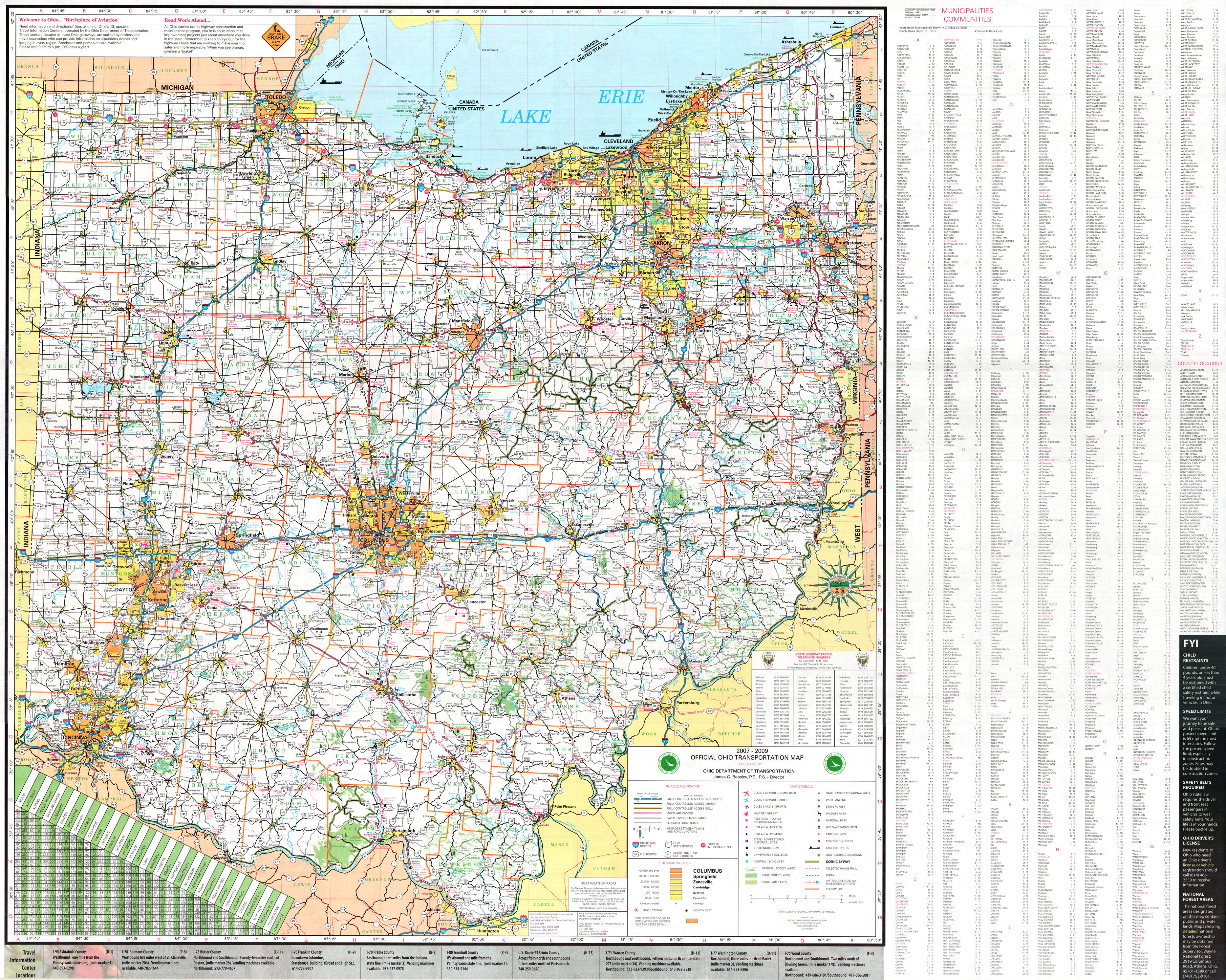
[edit]The entire length of the Ohio Turnpike is 241.3 miles (388.3 km), from the western terminus in Northwest Township near Edon, where it meets the Indiana Toll Road at the Ohio–Indiana border, to the eastern terminus in Springfield Township near Petersburg where it meets the Pennsylvania Turnpike at the Ohio–Pennsylvania border. Most of the turnpike, 218.7 miles (352.0 km) between the Indiana border and an interchange with Interstate 76 (I-76) near Youngstown, is signed as part of I-80, while the eastern 22.6 miles (36.4 km), between the I-80/I-76 interchange and the Pennsylvania border, is signed as part of I-76. For 142.8 miles (229.8 km), between the Indiana border and Elyria, I-90 is cosigned with I-80 as part of the turnpike.
The Ohio Turnpike does not pass directly into any major city, but does provide access to the four major metro areas in northern Ohio through connected routes. Two auxiliary Interstate highways, I-271 near Cleveland and I-475 near Toledo, cross the turnpike, but do not have direct connections. In Northwest Ohio, the turnpike passes through the southern part of the Toledo metropolitan area, with direct access to Toledo through I-75 and I-280.
In Northeast Ohio, the turnpike passes through the southern suburbs of Greater Cleveland and the northern edge of the Akron metro area, with direct access to Cleveland via I-71, I-77, I-90 and I-480. Akron is connected to the turnpike via I-77 and State Route 8 (SR 8) in the north and I-76 on the east. The turnpike is located on the western and southern edges of the Mahoning Valley, with direct access to Youngstown through the remaining portion of I-80 east of the Turnpike, and access to I-680 via the westbound lanes only.

In North Jackson, I-80 and I-76 swap rights-of-way at a double trumpet interchange; I-76 continues east as I-80 and I-80 continues southeast as I-76, carrying the turnpike with it. In Petersburg, the concurrent routes cross the state lines into Pennsylvania, automatically becoming the Pennsylvania Turnpike.
History
[edit]
In 1947 a bill was introduced in the Ohio General Assembly authorizing a privately financed roadway. Originally consisting of a system of five highways, the turnpike was reduced to one when the other four were made redundant by the Federal Aid Highway Act of 1956.[3] Construction for the road cost $326 million and was recorded as the biggest project in state history, with 10,000 employees, more than 2,300 bulldozers, graders, loaders and other machines over a 38-month period.[1][4]
On December 1, 1954, the first 22-mile (35 km) stretch (the portion lying east of SR 18) opened near the present-day exit 218 for I-76 and I-80. Several motorists attended a dedication ceremony, with over 1,000 people joining a caravan, following a snow plow and a patrol cruiser, to become the first to drive the turnpike. The remaining section from exit 218 west to Indiana opened on October 1, 1955.[5] A connecting ramp near the Indiana state line closed on August 16, 1956, the day before the Indiana Toll Road was opened; this ramp had been used to allow traffic access to US 20 to cross into Indiana.[6] As originally built, the turnpike offered 18 access points.[4]
The Ohio Turnpike originally had a 65 mph (105 km/h) limit for cars and 55 mph (89 km/h) limit for trucks. The automobile speed limit was increased on September 30, 1963, in concert with other Ohio rural Interstates to 70 mph (110 km/h).[7]
Exit 10 was rebuilt to provide access to Interstate 71 when that road was built across the turnpike, while still retaining access to its original US 42 access point. This came with a relocated toll plaza and trumpet interchange. The existing overpass was not demolished, though the original trumpet ramps were abandoned. The work was completed in November 1966.[8]
Exit 15 was rebuilt as part of construction of the ODOT maintained portion of interstate 80. Previously serving the surface alignment of Ohio Route 18, upon the opening of the new ramps, it would instead serve the road.[9] Work on the new interchange was completed in 1972.
In 1974, construction was completed on exit 8A, a new interchange with Interstate 90.
In 1974, construction began on exit 16A, a new interchange to serve Interstate 680.[10] It was completed in 1975.
The turnpike was renamed in honor of original chairman James W. Shocknessy in 1976.[3]
Due to the National Maximum Speed Law, a 55 mph speed limit took effect in 1974 for all vehicles. The 55 mph limit remained until 1987 when the Ohio General Assembly adopted the federally permitted 65 mph maximum speed limit, but for automobiles only.
In 1991, exit 4A was opened to serve Interstate 75.
On December 29, 1992, the unnumbered interchange at SR 49 was opened. There are no ramp tolls at this interchange; the Westgate toll barrier was, at the same time, demolished[11] and replaced by a new Westgate Toll barrier, which is located east of SR 49.[12][13]
In 1994, ticket dispensers were added to interchanges in order to reduce congestion.[14]
Many infill interchanges were added in the 1990s. Exit 6A was opened on December 15, 1994,[15] and exit 7A was opened the next year on December 13.[16] This was followed by exit 3B on December 20, 1996,[17] exit 5A on February 6, 1997,[18] and exit 2A on November 18, 1998.[19]
In December 2001, construction was completed on a project to reconstruct exit 11 to add new ramps to Interstate 77, in addition to replacing and expanding the toll plaza and ramps,[20] the former of which was left in as truck parking space.[21]
The Ohio Turnpike Commission began phasing in distance-based exit numbers in 1998. In September 2002, the sequential numbering system was retired.
Governor Taft asked the Ohio Turnpike Commission to work with ODOT and the OSHP to formulate a plan to encourage truck traffic to use the turnpike instead of parallel highways, improving the safety of those other roadways. The three organizations created a plan with three points. The truck speed limit was increased from 55 to 65 mph (89 to 105 km/h) for consistency with the automobile limits. Enforcement of truck weight and speed limits on parallel highways was increased, and truck toll rates were lowered in a trial. The speed limit increase took effect on September 8, 2004.[22]
Exit 7B opened on November 30, 2004. It had first been proposed in 1993.[23]
The Ohio Turnpike Commission had been hesitant to deploy an electronic tolling system, citing an apparent lack of commuter travel as well as significant implementation expenses. In December 2006, the commission indicated their intention to move forward with the implementation of an E-ZPass-compatible system as a "customer convenience".[24] The system was activated on October 1, 2009.[25] With this, signs were added to differentiate between E-ZPass lanes and traditional staffed toll lanes, and gates were installed to prevent motorists from evading tolls or causing accidents.[citation needed] They also added support for debit cards and credit cards for customers without E-ZPass, becoming the first publicly owned toll road in the U.S. (second overall) to allow users to pay tolls with a debit or credit card.[14]
On December 20, 2010, the Ohio Turnpike Commission voted to increase the speed limit of the Ohio Turnpike to 70 mph. Despite opposition from the Ohio Trucking Association, the increase was approved by the commission by a vote of 4–1[26][27] and went into effect on April 1, 2011.[28]
In July 2012, the way tickets were paid for was tweaked to deter truckers from trying to evade them, which had been an issue since the road opened. They also removed staffed toll lanes at the low-capacity interchanges.[29]
Ken Blackwell, the defeated candidate in the 2006 Ohio gubernatorial election, had announced a plan for privatizing the turnpike, similar to plans enacted on the Chicago Skyway and Indiana Toll Road.[30][31] In 2010 and 2011, Governor John Kasich stated that he would consider a turnpike lease, but only during a prosperous economic period.[32] In August 2011, Kasich stated his intention to create a task force to produce a leasing plan and also considered the option of reassigning the maintenance of the highway to the Ohio Department of Transportation (ODOT).[33] Ultimately he decided against both, instead proposing to issue more debt under the renamed Ohio Turnpike and Infrastructure Commission, with cash tolls raised annually over a ten-year period to compensate.[34]
A project to add one lane in each direction from Toledo to Youngstown was started in 1996, using financing from increased tolls. It was originally projected to be finished in 2005, but was not completed until the end of the 2014 construction season.[35]
In March 2019, the turnpike commission announced plans for a complete revamp of the toll barriers.[36][37] The Westgate toll plaza was demolished and replaced with a new facility 1 mile (1.6 km) east of the original one. The new toll plaza features three cash lanes in each direction along with two express E-ZPass lanes, allowing E-ZPass users to travel through the toll areas at 70 mph (110 km/h). In addition, the Eastgate toll plaza was converted to serve only westbound traffic, with five cash lanes and two express E-ZPass lanes. Two additional mainline toll plazas were built at milepost 49 in Swanton Township (on the former site of the Oak Openings and Fallen Timbers service plazas) and at milepost 211 in Newton Falls, which became the new western and eastern ends of the ticket system, and tolls ceased to be collected at exits between each respective new barrier and the nearest existing toll plaza, creating a simplistic barrier toll system between those stretches.[38][39][40] The construction also features new patron dynamic message signs that provide drivers with dynamic messaging.[41] Part of the largest building program on the toll road since its original opening in 1955, the system was implemented on April 10, 2024.[42] Driver confusion over the system prompted the OTIC to create a 60-day toll grace period on August 13, 2024.[43] The Ohio State Highway Patrol cited in a report that a series of fatal accidents at the Swanton barrier on August 15, 2024, were caused in part by this confusion, and the National Transportation Safety Board has opened an investigation into them.[44][45][46]
Services
[edit]
The Ohio Turnpike has had service plazas since its inception. Service plazas differ from typical freeway rest areas in that they offer amenities such as 24-hour food and fuel service; motorists do not have to pass through toll booths to re-fuel, use the restroom, or eat.
In 1998, the Ohio Turnpike Commission began modernizing the service plazas, first demolishing the original plazas and then reconstructing them from the ground up. Initially, the new plazas were rebranded by signage depicting them as "travel centers", but reverted to the original nomenclature.
In addition to modern restrooms, the new plazas offer several fast food choices, which vary between the plazas. They also include ATMs, gift shops, travel information counters, Wi-Fi internet access, and facilities for truck drivers, including shower facilities, lounge, and laundry areas. Sunoco fuel stations are provided at all service plazas along the Ohio Turnpike. The company signed a new contract to operate all 16 plazas on the Ohio Turnpike beginning in 2012.[47] Facilities for overnight RV campers are provided at the service plazas located at mile markers 20, 76, 139, and 197.[48]
Service plazas are located in pairs (one for each side of the turnpike) near mile markers 20, 76, 100, 139, 170, 197, and 237.
The Oak Openings and Fallen Timbers service plazas in Lucas County west of Toledo at mile marker 49 were the least utilized, so were closed and demolished; the Swanton toll barrier was later built at the site. A replacement pair of plazas had been planned to be built to the west in Fulton County,[49][50][51] but ultimately were not built. Due to the lack of a municipal water/sewer system, the Indian Meadow and Tiffin River service plazas located near mile marker 20 in Williams County were demolished in 2006,[50][52] though they were eventually rebuilt and reopened on June 29, 2011. The Glacier Hills and Mahoning Valley Service Plazas at mile 237 - also initially fated to be closed and demolished permanently - reopened in 2013.[53]
Since the turnpike opened, the Ohio Turnpike Commission has contracted with the Ohio State Highway Patrol (OSHP) District 10 to provide law enforcement, as well as assistance to disabled or stranded motorists. The Patrol is the only law enforcement agency with jurisdiction on the turnpike. It monitors Citizen's Band channel 9 for distress calls.
Tolls
[edit]
The Ohio Turnpike uses a ticket and barrier toll system. The Westgate and Eastgate toll plazas charge flat rate tolls, with Westgate charging a toll for a 2-axle vehicle of $3.50 with cash and $2.25 with E-ZPass in both directions, while Eastgate charges a toll of $4.25 with cash and $3 with E-ZPass in the westbound direction only. Between Swanton and Newton Falls, the turnpike uses a ticket system, with tolls calculated based upon the distance traveled as well as the height and axle-count of vehicle driven. As of January 2026[update], the toll for a 2-axle vehicle to travel between Swanton and Newton Falls is $20 with cash and $13.75 with E-ZPass.[54][55] There is no toll collection at exits between the Westgate and Swanton barriers, or between the Newton Falls and Eastgate barriers.
In April 2008, Governor Ted Strickland and legislative leaders announced a planned stimulus package that would redistribute Turnpike tolls to road projects throughout the state.[56][57] On May 23, the Ohio Senate Finance Committee voted to pass a new version of the package which would not involve tolls collected.[58]
Exit list
[edit]Until 1998, the turnpike numbered exits sequentially, but afterwards started the process of renumbering them by the milepost system. This was done to "alleviate confusion from the irregular sequence of numerical references" due to recently added interchanges as well as to conform to federal standards.[59] The conversion ran from January 1998[60] to September 2002[61] with dually posted numbers during that period.
| County | Location[62][63] | mi[55] | km | Old exit | New exit[55] | Destinations | Notes |
|---|---|---|---|---|---|---|---|
| Williams | Northwest Township | 0.0 | 0.0 | Continuation into Indiana; western end of I-80/I-90 concurrency | |||
| 2.0 | 3.2 | — | 2 | Diamond interchange | |||
| 4.0 | 6.4 | Westgate Toll Barrier | |||||
| Holiday City | 13.5 | 21.7 | 2 | 13 | Last westbound exit before toll | ||
| Brady Township | 20.8 | 33.5 | Indian Meadow Service Plaza (westbound) Tiffin River Service Plaza (eastbound) | ||||
| Fulton | Franklin Township | 25.5 | 41.0 | 2A | 25 | ||
| Dover Township | 34.9 | 56.2 | 3 | 34 | |||
| Pike Township | 39.8 | 64.1 | 3B | 39 | Last eastbound exit before toll | ||
| Lucas | Swanton Township | 49.0 | 78.9 | Swanton Toll Barrier (western end of ticket system) | |||
| Monclova Township | 52.6 | 84.7 | 3A | 52 | |||
| Maumee | 59.5 | 95.8 | 4 | 59 | |||
| Wood | Rossford | 64.9 | 104.4 | 4A | 64 | I-75 exit 195 | |
| Lake Township | 71.7 | 115.4 | 5 | 71 | I-280 exit 1A | ||
| Ottawa | Harris Township | 76.9 | 123.8 | Blue Heron Service Plaza (westbound) Wyandot Service Plaza (eastbound) | |||
| 81.8 | 131.6 | 5A | 81 | ||||
| Sandusky | Sandusky Township | 91.6 | 147.4 | 6 | 91 | ||
| Riley Township | 100.0 | 160.9 | Erie Islands Service Plaza (westbound) Commodore Perry Service Plaza (eastbound) | ||||
| Erie | Groton Township | 110.2 | 177.3 | 6A | 110 | ||
| Milan Township | 118.5 | 190.7 | 7 | 118 | |||
| Lorain | Brownhelm Township | 135.9 | 218.7 | 7A | 135 | ||
| Amherst Township | 139.5 | 224.5 | Middle Ridge Service Plaza (westbound) Vermilion Valley Service Plaza (eastbound) | ||||
| 140.6 | 226.3 | 7B[b] | 140 | ||||
| Elyria Township | 142.8 | 229.8 | 8A | 142 | Eastbound exit and westbound entrance; eastern end of I-90 concurrency | ||
| Elyria | 145.5 | 234.2 | 8 | 145 | |||
| North Ridgeville | 151.8 | 244.3 | 9A | 151 | Eastbound exit and westbound entrance | ||
| 152.2 | 244.9 | 9 | 152 | Westbound access to I-480 | |||
| Cuyahoga | Strongsville | 161.8 | 260.4 | 10 | 161 | I-71 exit 233 | |
| Broadview Heights | 170.1 | 273.7 | Great Lakes Service Plaza (westbound) Towpath Service Plaza (eastbound) | ||||
| Summit | Richfield | 173.2 | 278.7 | 11 | 173 | ||
| Boston Heights | 180.3 | 290.2 | 12 | 180 | |||
| Portage | Streetsboro | 187.2 | 301.3 | 13 | 187 | ||
| Shalersville Township | 193.9 | 312.1 | 13A | 193 | |||
| Freedom Township | 197.0 | 317.0 | Portage Service Plaza (westbound) Brady's Leap Service Plaza (eastbound) | ||||
| Trumbull | Braceville Township | 209.2 | 336.7 | 14 | 209 | ||
| 211.0 | 339.6 | Newton Falls Toll Barrier (eastern end of ticket system) | |||||
| Lordstown | 215.0 | 346.0 | 14A | 215 | Ellsworth–Bailey Road – Lordstown West | Eastbound exit and westbound entrance | |
| 216.4 | 348.3 | 14B | 216 | General Motors Parkway – Lordstown East | Westbound exit and eastbound entrance; to SR 45; last westbound exit before toll | ||
| Mahoning | Jackson Township | 218.7 | 352.0 | 15 | 218 | Eastern end of I-80 concurrency; western end of I-76 concurrency; I-680 not signed westbound | |
| Beaver Township | 232.9 | 374.8 | 16 | 232 | Last eastbound exit | ||
| 234.1 | 376.7 | 16A | 234 | Westbound exit and eastbound entrance | |||
| Springfield Township | 237.2 | 381.7 | Mahoning Valley Service Plaza (westbound) Glacier Hills Service Plaza (eastbound) | ||||
| 239.1 | 384.8 | Eastgate Toll Barrier (westbound) | |||||
| 241.3 | 388.3 | Continuation into Pennsylvania; eastern end of I-76 concurrency | |||||
1.000 mi = 1.609 km; 1.000 km = 0.621 mi
| |||||||
See also
[edit]Notes
[edit]References
[edit]- ^ a b Goodman, Rebecca; Brunsman, Barrett J. (2005). This Day in Ohio History. Cincinnati: Emmis Books. ISBN 1-57860-191-6.[page needed]
- ^ Ohio General Assembly (July 1, 2013). "5537.02 Ohio turnpike and infrastructure commission". Ohio Revised Code. Retrieved September 2, 2013.
- ^ a b Grant, Alison (September 24, 2015). "Ohio Turnpike Opened 60 Years Ago to Swarms of Onlookers at Midnight Ceremony". The Plain Dealer. Cleveland. Retrieved September 28, 2015.
- ^ a b Ohio Turnpike Commission (n.d.). "History: A Dream Realized..." Ohio Turnpike Commission. Archived from the original on August 3, 2009. Retrieved August 11, 2009.
- ^ Ohio State Highway Patrol (n.d.). "Chapter 3: Giant Strides, 1946–1964". The First 60 Years, A History of Service. Ohio State Highway Patrol. Archived from the original on March 2, 2008. Retrieved July 10, 2007.
- ^ "Exit on Ohio Turnpike Closed". The Pittsburgh Press. August 16, 1956. p. 7. Retrieved August 27, 2012.
- ^ Ohio Turnpike Commission CFO/Comptroller’s Office and the Office of Public Affairs & Marketing (March 16, 2006). "Comprehensive Annual Financial Report for the Year Ended December 31, 2005" (PDF). Berea: Ohio Turnpike Commission. p. 22. Archived from the original (PDF) on May 29, 2014. Retrieved May 29, 2014.
- ^ "Minutes of the two hundred and third meeting" (PDF). December 6, 1966. Archived from the original (PDF) on July 7, 2021.
- ^ "Ohio turnpike commission - Resolution Closing Old Interchange No. 15" (PDF). February 6, 1970. Archived from the original (PDF) on July 5, 2021.
- ^ "Resolution Awarding Contract RMP 55-74-2 for Construction of Toll Plaza and Related Work at Interchange Between the Ohio Turnpike and Interstate Route 680" (PDF). Archived from the original (PDF) on July 5, 2021.
- ^ United States Geological Survey (1990). Clear Lake, Ind.–Ohio–Mich (Topographic map). 1:24,000. 7.5 minute. Reston, Virginia: United States Geological Survey. Archived from the original (PDF) on April 8, 2013. Retrieved August 27, 2012.
- ^ Lewis, Herb (December 30, 1992). "Turnpike Exchange near Edon Is Officially Opened". The Bryan Times. Retrieved August 26, 2012.
- ^ Harvey, Hank (February 28, 1993). "Turnpike Commission May Branch Out". The Blade. Toledo, Ohio. Retrieved August 26, 2012.
- ^ a b Farkas, Karen (June 8, 2009). "Ohio Turnpike To Let Drivers Pay Tolls with Credit, Debit Cards". The Plain Dealer. Cleveland. Retrieved June 8, 2009.
- ^ McEaneney, Dennis (December 2, 1994). "Gate 13A Joins Pike". Akron Beacon Journal. Retrieved June 16, 2008.
- ^ Kavanaugh, Molly (December 14, 1995). "New Turnpike Interchange Opens at Baumhart Road". The Plain Dealer. Cleveland. Retrieved June 16, 2008.
- ^ "Fulton County Turnpike Gate To Open Friday". The Blade. Toledo, Ohio. December 17, 1996. Retrieved June 16, 2008.
- ^ Patch, David (February 7, 1997). "Turnpike's Gate 5A Opens, Widens Elmore Area Access". The Blade. Toledo, Ohio. Retrieved June 16, 2008.
- ^ Patch, David (November 10, 1998). "Archbold Turnpike Exit to Open". The Blade. Toledo, Ohio. Retrieved June 18, 2008.
- ^ Higgins, John (December 2, 2001). "I-77 Ramps Add to Flow at Turnpike". Akron Beacon Journal. p. E1. Retrieved May 20, 2001 – via Newspapers.com.
- ^ "Google Maps".
- ^ Ohio Turnpike Commission CFO/Comptroller’s Office and the Office of Public Affairs & Marketing (March 16, 2006). "Comprehensive Annual Financial Report for the Year Ended December 31, 2005" (PDF). Berea: Ohio Turnpike Commission. p. 28. Archived from the original (PDF) on May 29, 2014. Retrieved May 29, 2014.
- ^ "Turnpike Ramp at SR 58 To Open Today After 11 Years". The Morning Journal. Lorain, Ohio. November 30, 2004. Retrieved June 16, 2008.[permanent dead link]
- ^ Ohio Turnpike Commission (n.d.). "E-ZPass Frequently Asked Questions". Ohio Turnpike Commission. Archived from the original on July 27, 2011. Retrieved August 7, 2011.
- ^ Farkas, Karen (October 2, 2009). "E-ZPass Debut Has Bugs, but Turnpike Officials Are on the Case". The Plain Dealer. Cleveland. Retrieved October 2, 2009.
- ^ Ohio Turnpike Commission (December 20, 2010). "Resolution Providing for a Uniform Speed Limit of 70 MPH for the Entire Ohio Turnpike" (PDF). Ohio Turnpike Commission. Archived from the original (PDF) on December 27, 2010. Retrieved December 20, 2010.
- ^ Ewinger, James (December 20, 2010). "Ohio Turnpike Commission Votes To Raise Toll Road's Speed Limit to 70 mph". The Plain Dealer. Cleveland. Retrieved December 20, 2010.
- ^ Breckenridge, Tom (April 1, 2011). "Ohio Turnpike Drivers Can Press the Pedal a Bit More as Speed Limit Climbs to 70 mph". The Plain Dealer. Cleveland. Retrieved April 2, 2011.
- ^ "Ohio Turnpike moves to curb toll-ticket scam by truckers". August 15, 2012.
- ^ Theis, Sandy (June 4, 2006). "Leasing Turnpike: A Road to Riches? Blackwell Says His Plan Could Net Millions for Cities, but Others Urge Caution". The Plain Dealer. Cleveland. Retrieved June 18, 2008.
- ^ Pierce, Gene (January 24, 2006). "Lease Turnpike to Create $4–6 Billion Job Development Fund" (Press release). Ohioans for Blackwell. Archived from the original on November 1, 2006. Retrieved June 18, 2008.
- ^ Feran, Tom (January 19, 2011). "Gov. John Kasich Hasn't Dismissed Privatizing Ohio Turnpike, if the Numbers Are Right". PolitiFact Ohio. Retrieved January 24, 2011.
- ^ Fields, Reginald (August 12, 2011). "Gov. John Kasich Moves Ahead with Turnpike Leasing Proposal". The Plain Dealer. Cleveland. Retrieved August 12, 2011.
- ^ Breckenridge, Tom (December 13, 2012). "Gov. Kasich Wants to Issue $1.5 Billion in Ohio Turnpike Debt for Projects in Northern Ohio". The Plain Dealer. Cleveland. Retrieved December 13, 2012.
- ^ Grant, Alison (January 15, 2014). "Ohio Turnpike's Final Third-lane Section to Be Built This Summer; Other Turnpike Construction Planned This Year". The Plain Dealer. Cleveland. Retrieved January 26, 2014.
- ^ Gauntner, Mike (March 19, 2019). "Ohio Turnpike plans to remove toll gates". Youngstown, Ohio: WFMJ-TV. Retrieved March 19, 2019.
- ^ Ahmed, Ferzan M. (March 2019). "Priorities Include Modernizing our Toll Collection System". Customer Connection. Ohio Turnpike and Infrastructure Commission. Retrieved March 21, 2019.
- ^ Patch, David (December 12, 2021). "With Barrier-Free Tolls on Horizon, Ohio Turnpike Faces Challenge from Out-of-State Scofflaws". The Blade. Toledo, Ohio. Retrieved February 2, 2022.
- ^ Ohio Turnpike and Infrastructure Commission (n.d.). "Toll Collection System Modernization". Ohio Turnpike and Infrastructure Commission. Archived from the original on January 15, 2022. Retrieved February 4, 2022.
- ^ "More Truckers Opt to Use E-ZPass on Ohio Turnpike". Transport Topics. November 24, 2022.
- ^ "Big Changes Underway Along Ohio Turnpike: What You Can Expect Amid Removal of Gates at Toll Plazas, Lane Conversions". Cleveland: WKYC-TV. August 24, 2022.
- ^ VanMetre, Elizabeth (April 10, 2024). "Ohio Turnpike Launches New Toll Collection System". News 5 Cleveland. Cleveland: WEWS-TV. Retrieved April 10, 2024.
- ^ Pelzer, Jeremy (August 27, 2024). "Ohio Turnpike suspends late fees, unpaid toll collections, citing motorist 'growing pains' with new toll system". The Plain Dealer. Cleveland. Retrieved August 29, 2024.
- ^ Dugger, Brian (September 18, 2024). "OSHP: Driver in initial deadly Ohio Turnpike crash was confused by new Swanton toll plaza at center of 11 Investigates reports". WTOL. Retrieved October 16, 2024.
- ^ Ludwig, Karmann (September 25, 2024). "NTSB confirms events of fatal Ohio Turnpike crash that killed four". WTOL. Retrieved October 16, 2024.
- ^ "Rear-End Collision and Subsequent Multivehicle Collisions near Toll Plaza on Interstate 80". National Transportation Safety Board. September 25, 2024. Retrieved October 16, 2024. Investigation ID HWY24MH013.
- ^ Maykuth, Andrew (December 24, 2010). "Sunoco Adding Sales Outlets in Ohio, N.Y." The Philadelphia Inquirer. Archived from the original on July 14, 2014. Retrieved March 5, 2012.
- ^ Ohio Turnpike Commission (n.d.). "Service Plazas". Ohio Turnpike Commission. Archived from the original on October 6, 2012. Retrieved October 20, 2012.
- ^ Ohio Turnpike Commission (May 16, 2005). "Resolution Approving the Acquisition of Right-of-Way for Construction of Service Plaza Facilities in Fulton County". Ohio Turnpike Commission. Archived from the original on September 27, 2007. Retrieved August 7, 2011.
- ^ a b "Williams County Turnpike Plazas Will Be Closed". The Blade. Toledo, Ohio. August 16, 2005. Archived from the original on September 30, 2007. Retrieved August 7, 2011.
- ^ Farkas, Karen (November 2, 2009). "Whatever Happened to ...?: Whatever Happened to Plans To Add a Third Lane to the Ohio Turnpike and Replace the Eight Sets of Service Plazas?". The Plain Dealer. Cleveland. Retrieved November 3, 2009.
- ^ Ohio Turnpike Commission (August 15, 2005). "Resolution Authorizing the Closure of Indian Meadow and Tiffin River Service Plazas at Milepost 20.8 in Williams County". Ohio Turnpike Commission. Archived from the original on May 24, 2006. Retrieved August 7, 2011.
- ^ Breckenridge, Tom (August 18, 2012). "Ohio Turnpike Says Problems with Contractor Delay New Service Plazas". The Plain Dealer. Retrieved August 18, 2012.
- ^ "Ohio Turnpike Tolls And Toll Calculator". ohioturnpike.org. Retrieved March 20, 2025.
- ^ a b c Ohio Turnpike Commission (n.d.). "Interchanges". Ohio Turnpike Commission. Archived from the original on August 17, 2011. Retrieved August 7, 2011; Ohio Turnpike Commission; Travel Boards (2012). Ohio Turnpike Map & Lodging Guide (Map). Berea: Ohio Turnpike Commission.
- ^ Marshall, Aaron (April 3, 2008). "Ohio Tries To Retain Top Talent in College; Internship Plan Raids Tobacco, Turnpike Funds". The Plain Dealer. Cleveland. Retrieved April 8, 2008.
- ^ Hollander, Sarah; Marshall, Aaron (April 5, 2008). "Turnpike Officials Unsure What Revenue Loss Will Mean". The Plain Dealer. Cleveland. Retrieved April 8, 2008.
- ^ Marshall, Aaron (May 23, 2008). "State Stimulus Package Won't Include Turnpike Funds". The Plain Dealer. Cleveland. Retrieved May 28, 2008.
- ^ Ohio Turnpike Commission (n.d.). "Interchange Number Conversion". Ohio Turnpike Commission. Archived from the original on December 4, 2002. Retrieved February 20, 2019.
- ^ Hakos Dehrmann, Lauren (May 23, 2002). "Plans Underway to Switch Interchange Numbers to Milemarkers" (Press release). Ohio Turnpike Commission. Archived from the original on June 9, 2002. Retrieved February 20, 2019.
- ^ Hakos Dehrmann, Lauren (September 13, 2002). "Turnpike Interchange Signs Switching Over This Month" (Press release). Ohio Turnpike Commission. Archived from the original on December 4, 2002. Retrieved February 20, 2019.
- ^ Ohio Department of Transportation (January 2007). Official Ohio Transportation Map (Map) (2007–2009 ed.). c. 1:570,240. Columbus: Ohio Department of Transportation. OCLC 5673562, 31884639.[full citation needed]
- ^ DeLorme (2007). Street Atlas USA (Map). DeLorme.
- ^ "Interchanges [91 to 161]". Ohio Turnpike Commission. c. 1999. Archived from the original on January 19, 2000. Retrieved February 25, 2023.
- ^ Dehrmann, Lauren (November 29, 2004). "Long-awaited interchange at S.R. 58 scheduled to open" (Press release). Ohio Turnpike Commission. Archived from the original on December 15, 2004. Retrieved February 25, 2023.
External links
[edit]Ohio Turnpike
View on GrokipediaThe James W. Shocknessy Ohio Turnpike is a 241-mile (388 km) limited-access toll highway extending across northern Ohio from the Pennsylvania state line near Shenango Township to the Indiana state line near Butler, Indiana.[1] It primarily overlays Interstate 80 (I-80) and Interstate 90 (I-90) for most of its length, with auxiliary segments incorporating Interstate 76 (I-76), Interstate 480 (I-480), and other connectors, facilitating high-volume freight and passenger traffic between the Midwest and East Coast.[1] Authorized by the Ohio General Assembly in 1949, the turnpike's construction commenced with groundbreaking on October 27, 1952, and concluded in 35 months, involving 10,000 workers and funded by $326 million in revenue bonds secured against future tolls.[2] Opened on October 1, 1955, it represented one of the earliest modern superhighways in the United States, providing uninterrupted, divided-lane travel that dramatically reduced cross-state journey times and boosted regional economic connectivity upon completion.[2] Managed by the Ohio Turnpike and Infrastructure Commission, the roadway includes 31 interchanges—26 linking to U.S., state, and interstate routes—and service plazas spaced every 30 to 50 miles for traveler amenities.[3] Toll revenues, collected via an open-road system implemented in 2024 using E-ZPass detection and license plate cameras, fund operations, maintenance, and debt service, with rates adjusted annually; however, the system's transition has generated complaints over erroneous billing and enforcement delays.[1][4] The turnpike handles substantial commercial trucking volumes, contributing to Ohio's logistics infrastructure while debates persist over toll escalation and diversion of funds to non-turnpike projects.[5]
Geographical and Technical Overview
Route Description
The Ohio Turnpike spans 241 miles (388 km) across northern Ohio, functioning as a controlled-access highway connecting the Indiana state line near Edon with the Pennsylvania state line near New Springfield.[4] It primarily follows a concurrency of Interstate 80 (I-80) and Interstate 90 (I-90) for its western 219 miles (352 km), from the Indiana border to a major junction near Youngstown, before transitioning to I-76 for the remaining 22 miles (35 km) eastward to Pennsylvania.[6] This alignment positions the turnpike as a key transcontinental route, bypassing urban cores while providing radial access to major population centers including Toledo, Cleveland, and Akron.[7] From its western terminus at the Indiana–Ohio border (milepost 0), the turnpike continues the Indiana Toll Road's I-80/I-90 designation eastward through predominantly rural and agricultural terrain in Williams and Fulton counties. Early interchanges include Exit 2 for State Route 49 (SR 49) near Edgerton, Exit 13 for SR 15 serving Bryan and Montpelier, and Exit 25 for SR 2 near Archbold.[8] Progressing into Lucas and Wood counties, it skirts south of Toledo, with Exit 71 offering I-280 southward to Interstate 75 (I-75) and downtown Toledo; additional local accesses occur at Exit 49 (SR 2 to Oregon), Exit 56 (SR 101), and Exit 64 (SR 4 to Fremont).[8] The route then traverses Erie, Huron, and Lorain counties, characterized by flat to gently rolling farmland and small communities, featuring interchanges such as Exit 91 (SR 53), Exit 110 (SR 18 near Norwalk), Exit 118 (SR 250), and Exit 140 (SR 58 to Amherst and Elyria).[8] Entering the Cleveland metropolitan area around milepost 140, the turnpike maintains a southern bypass of the city, avoiding dense urban traffic via a high-speed alignment through Cuyahoga and Medina counties. Access to Cleveland proper, its airport, and northern suburbs is facilitated by the extensive I-480 interchange complex, spanning multiple exits (including connections for I-480 south at approximately mile 142 and northbound segments linking to I-71 and Lake Erie).[9] Eastbound progression includes Exit 180 for I-77 (accessing Akron to the south) and Exit 209 for I-71 near Strongsville, serving Medina and southern suburbs.[8] In Portage County, the route reaches its designation shift at Exit 218 near Brimfield and Ravenna, where I-80 diverges northeast (exiting the toll facility), I-90 terminates its concurrency, and the southern I-76 leg from Akron merges; from here, the turnpike proceeds east as I-76 through Mahoning County, south of Youngstown, with interchanges at Exit 225 (SR 14) and Exit 232 (SR 7 and SR 11), before terminating at the Pennsylvania border at milepost 241 and linking to the Pennsylvania Turnpike's I-76/I-70 mainline.[7][8] The entire facility comprises six lanes for most of its length, with 31 interchanges and auxiliary ramps supporting regional connectivity.[10]Engineering and Design Features
The Ohio Turnpike was designed and constructed as a limited-access, divided superhighway emphasizing nonstop, high-speed travel across northern Ohio's relatively flat terrain. Opened in 1955 after construction from 1952 to 1955, it spans 241 miles with concrete pavement surfaces and steel bridge spans engineered for durability and efficiency.[2] The original roadway featured 12-foot travel lanes and paved shoulders typically 10 feet wide, with grass medians varying from 20 to 60 feet to enhance safety through separation and recovery space.[11] [12] Geometric design prioritized gentle horizontal curves and minimal vertical grades to support sustained high speeds, with the current posted limit of 70 mph reflecting adaptations from the original intent for faster travel.[5] While curve radii often fall short of modern standards, contributing to occasional loss-of-control risks at the 10 principal curves, the overall alignment minimizes steep inclines, leveraging Ohio's topography for grades generally under 3 percent.[13] [5] Interchanges employ grade-separated configurations, including full cloverleaves and partial interchanges, though some ramps predate current design criteria without significantly impacting safety outcomes.[5] Bridge engineering adheres to specialized standards diverging from the Ohio Department of Transportation (ODOT) manual, mandating approach slabs on all mainline and ramp structures to mitigate settlement differentials.[14] Superstructures avoid cast-in-place concrete slabs and prestressed box beams, favoring laminated elastomeric bearings for expansion and rotation, with concrete strengths specified at 4.5 ksi for superstructures and 4.0 ksi for substructures; no future wearing surface is incorporated.[14] Notable examples include the twin high-level bridges over the Cuyahoga River Valley, reconstructed during widening projects to accommodate added lanes while preserving structural integrity.[15] Pavement rehabilitation has replaced over 246 lane-miles of the original concrete base since the 1990s, incorporating asphalt overlays in select segments while retaining core design elements for longevity under heavy traffic volumes exceeding 10 million vehicles annually in early operations.[12] [2] Modern updates include raised pavement markers and epoxy striping for enhanced visibility, with temporary lane widths reducible to 10 feet during maintenance without compromising essential geometry.[16]Historical Development
Planning and Construction Era (1940s–1955)
In the post-World War II era, Ohio policymakers identified the need for limited-access toll roads to alleviate congestion on existing highways and stimulate economic growth by facilitating faster freight and passenger transport across the state. The Ohio General Assembly responded by passing the Ohio Turnpike Act (Chapter 5537 of the Ohio Revised Code), effective September 1, 1949, which created the Ohio Turnpike Commission as an independent body corporate and politic empowered to issue bonds, acquire rights-of-way, and construct self-financing superhighways without relying on general tax revenues.[2][3] The Commission prioritized an east-west corridor designated as Project No. 1, spanning 241 miles through northern Ohio to connect with the Indiana Toll Road on the west and the Pennsylvania Turnpike on the east. Engineering assessments in 1951, which emphasized cost-effective right-of-way acquisition to minimize landowner disputes and expenses, finalized the alignment crossing 13 counties, four major rivers, 38 creeks, and intersecting or passing over/under 282 other roads.[2][17][18] To fund the estimated $326 million cost—the largest revenue bond issuance in U.S. history at the time—the Commission sold turnpike revenue bonds in 1952, secured exclusively by projected toll collections rather than state backing, ensuring fiscal independence.[2][18][19] Construction launched with groundbreaking on October 27, 1952, mobilizing a peak workforce of 10,000 laborers and over 2,300 pieces of heavy equipment to build four 24-foot lanes with 10-foot shoulders, numerous bridges, and interchanges designed for high-speed travel. Despite the scale—Ohio's largest public works project to date—the effort concluded in 35 months, with the entire turnpike opening to 44,000 vehicles on October 1, 1955, predating the federal Interstate Highway System.[2][20]Early Operations and Expansions (1955–2000)
The Ohio Turnpike commenced operations on October 1, 1955, following the completion of its 241-mile east-west mainline from the Indiana border near Pioneer to the Pennsylvania border east of New Lisbon. Opening-day traffic reached 44,000 vehicles, marking an immediate success for the self-financing toll road funded by $326 million in revenue bonds issued in 1952. Initial regulations included speed limits of 65 mph for automobiles and 55 mph for trucks, with full-trip tolls at $3 for passenger cars. Toll collection operated via a manual ticket system, where drivers received tickets at entry points and paid upon exit based on distance traveled.[2][18] The first full calendar year, 1956, saw 10 million vehicles—comprising roughly 8.5 million automobiles and 1.5 million trucks—utilize the facility, demonstrating robust demand amid postwar economic growth and the absence of competing limited-access highways. Traffic volumes exhibited steady increases through the late 20th century, supported by the Turnpike's designation as portions of Interstates 80 and 90 following the 1956 Federal-Aid Highway Act, which integrated the preexisting route into the national Interstate System without federal funding. A notable surge occurred in 1971 upon the linkage to the newly completed Interstate 80 extension across Pennsylvania, boosting volumes at the Youngstown-area eastern interchange by 63% that year. By the end of the century, annual traffic approached levels reflecting the roadway's role as a critical freight and passenger corridor, though exact 2000 figures aligned with broader trends of consistent growth absent major disruptions like the 1970s energy crises.[2][18][21] Expansions from 1955 to 2000 focused on enhancing connectivity rather than extending the core mainline length, which remained fixed at 241 miles as originally planned under Project No. 1 of a broader (but unrealized) state toll network. The system added 14 new interchanges beyond the original 17, improving access to growing suburban and industrial areas while minimizing disruption to the controlled-access design. These additions facilitated spurs and connectors, such as alignments tying into Interstate 480 and other radials, though specific construction dates for individual interchanges varied across decades. Operational improvements included periodic toll adjustments to attract commercial traffic—such as reductions for trucks to shift loads from parallel free roads—and maintenance initiatives to address wear from rising heavy-vehicle usage. In 1976, the Turnpike was renamed the James W. Shocknessy Ohio Turnpike in honor of the Ohio Turnpike Commission's inaugural chairman, who oversaw its development until his death that year. By 1998, the Commission began transitioning to distance-based exit numbering from sequential markers, aiding navigation as the route's complexity grew with added access points.[22][23][24]21st-Century Modernizations and Challenges
In the early 2000s, the Ohio Turnpike Commission initiated a $700 million third-lane widening program spanning 160 miles from the Toledo area to Youngstown, adding capacity to address growing traffic volumes and improve safety on the original two-lane sections built in the 1950s.[25] This project, executed in phases through the 2000s and 2010s, expanded much of the mainline to three lanes in each direction, reducing congestion and enhancing freight mobility along the corridor connecting Chicago and the Northeast.[26] The most significant upgrade in recent years has been the Toll Collection System (TCS) modernization, the largest capital project since the Turnpike's 1955 opening, involving over $1 billion in investments for infrastructure, technology, and operations.[27] Completed in phases with full implementation by April 2024, it reduced the number of toll plazas from 31 to 24, introduced open-road tolling for E-ZPass users allowing non-stop travel at highway speeds, and upgraded 216 lanes with automated gantries, self-service kiosks, and gated exits for cash/credit payers.[28][29] These changes, including four new mainline plazas at mileposts 3, 49, 139, and 211, aimed to cut travel times, boost throughput, and integrate video tolling for non-transponder vehicles, though initial rollout encountered billing errors prompting temporary suspension of late fees and collections.[30][31] Funding these enhancements has relied heavily on toll revenues and bond issuances, leading to periodic rate hikes—such as the 2014 increase that raised passenger vehicle tolls by about 25% to support $1.5 billion in statewide transportation projects beyond Turnpike maintenance.[32] This approach sparked legal challenges, including a 2015 federal class-action lawsuit alleging unconstitutional diversion of $930 million in tolls to non-Turnpike highways like the Opportunity Corridor, violating the federal ban on using toll revenues for unrelated purposes; most claims were dismissed in 2015, though debates over fiscal stewardship persisted.[33][34] Additional controversies included a 2018 $1 million judgment against the Commission for property access issues during expansions and ongoing criticisms of debt accumulation, with senior lien bonds funding capital needs amid projections of rising maintenance costs from aging pavements and bridges.[35] Toll rates continued upward, reaching 7.1 cents per mile for E-ZPass passenger vehicles in 2025, reflecting pressures from inflation, deferred upkeep, and revenue shortfalls exacerbated by competition from parallel free interstates.[36][37]Governance and Operations
Administrative Structure
The Ohio Turnpike and Infrastructure Commission (OTIC), established as a body corporate and politic under Ohio Revised Code Section 5537.02, serves as the primary administrative authority for the Ohio Turnpike, functioning as a state instrumentality responsible for its construction, operation, maintenance, and related infrastructure projects.[38] The commission operates independently from the Ohio Department of Transportation (ODOT), though it collaborates on certain matters, and is headquartered at 682 Prospect Street in Berea, Ohio.[39][40] The OTIC comprises ten members, divided into seven voting members and three non-voting members. Voting members include six individuals appointed by the Governor of Ohio with the advice and consent of the Ohio Senate—no more than three of whom may belong to the same political party—and the Director of the Ohio Department of Transportation (or designee) serving ex officio. Appointed members must be Ohio residents and qualified electors for at least five years prior to appointment, with terms lasting five years on a staggered basis. Non-voting members consist of the Director of the Ohio Office of Budget and Management (or designee) serving ex officio, one member appointed by the President of the Ohio Senate, and one appointed by the Speaker of the Ohio House of Representatives, with legislative appointees serving for the remainder of their General Assembly terms. A quorum requires four voting members, and commission actions necessitate at least four affirmative votes from voting members.[38][39] Day-to-day administration is led by an Executive Director, currently Ferzan M. Ahmed, P.E., who oversees operations including toll collection, maintenance, and engineering.[1][41] Senior staff includes roles such as Chief Financial Officer, Chief Information Officer, and Chief Engineer, supporting departments for finance, engineering, and customer service. The commission's activities are further monitored by the six-member Turnpike Legislative Review Committee, comprising legislators who provide oversight on operations and budgeting. Commission members receive annual compensation of $5,000, and meetings are held regularly to address governance, with resolutions documented publicly.[42][3][39]Toll Collection and Revenue Management
The Ohio Turnpike utilizes a hybrid toll collection system managed by the Ohio Turnpike and Infrastructure Commission, combining electronic open-road tolling for E-ZPass transponder users with a barrier-based entry-exit ticket system for cash and credit card payers.[4][43] In April 2024, the Commission fully implemented a modernization program initiated in phases starting in early 2023, featuring dedicated high-speed gantries for E-ZPass detection that eliminate stops for transponder-equipped vehicles, while non-E-ZPass drivers pull entry tickets at interchanges and settle flat-rate or mileage-based tolls at gated exit plazas.[27][44] This upgrade reduced mainline toll plazas from 31 to 24 and removed physical barriers from E-ZPass lanes, cutting operational costs through decreased staffing and maintenance needs while enhancing throughput.[45] E-ZPass adoption has risen progressively, reaching 74.1% of total transactions in 2023—64.5% for passenger vehicles (up 2.1% from 2022) and 89.6% for commercial trucks (up 0.4%)—driven by incentives including average toll discounts of 33% relative to cash rates and seamless interstate compatibility.[4][46][47] Non-transponder users face higher exact-change or credit fees, with recent adjustments allowing round-trip flat-rate payments at select plazas to mitigate violations from unpaid tolls.[48] The system processes tolls via overhead scanners and license plate imaging for enforcement, with outstanding invoices mailed and accruing administrative fees if unresolved.[1] Revenue management centers on tolls as the primary income stream, generating the bulk of the Commission's nearly $448 million in total 2024 revenues—a 7% year-over-year increase from 2023—augmented by concessions, investment yields, and allocated fuel taxes.[49] Funds are allocated per statutory mandates to cover operations, debt service on revenue bonds financing capital projects like widenings and interchanges, maintenance reserves, and system expansions, with surpluses reinvested in infrastructure to sustain self-sufficiency without general tax reliance.[50][51] The Commission issues senior lien bonds backed by pledged net toll revenues, maintaining investment-grade ratings through conservative budgeting and audited financial oversight, as detailed in annual comprehensive financial reports.[52][49] Modernization efforts, including E-ZPass expansion, directly bolster revenue collection efficiency by minimizing leakage from evasion and optimizing cash flow projections for bond covenants.[4]Facilities and Services
Service Plazas and Amenities
The Ohio Turnpike maintains 14 service plazas, operated in eastbound and westbound pairs at seven primary locations, spaced approximately every 30 to 50 miles to facilitate traveler breaks.[53] These facilities operate 24 hours a day, year-round, including holidays, offering fuel stations with motor oils and supplies, restrooms, picnic grounds, pet walking areas, and retail services such as convenience stores, gift shops, and snack vending machines.[54] Dining options typically include national fast-food chains like Burger King, Dunkin' Donuts, Starbucks, Panera Bread, Pizza Hut, and KFC, varying by plaza, alongside grab-and-go items from Pike Plazas.[55][56][57] Dedicated amenities for commercial truckers are available at all plazas, featuring separate lounges with couches, tables, free televisions, four private complimentary shower suites, and coin-operated laundry facilities with detergent available for purchase.[54] Free 24-hour overnight parking for trucks is provided adjacent to these lounges, with capacities ranging from 84 to 118 spaces per plaza depending on the location. Select plazas, including Tiffin River, Wyandot, Vermilion Valley, and Brady's Leap (eastbound) and Portage, Middle Ridge, Blue Heron, and Indian Meadow (westbound), offer designated RV lots with up to 11 spaces each, including electrical hookups, potable water, and dump stations for a $20 nightly fee payable via self-service kiosks.[58][59] Electric vehicle fast-charging stations are installed at ten plazas: Indian Meadow, Tiffin River, Blue Heron, Wyandot, Middle Ridge, Vermilion Valley, Great Lakes, Towpath, Mahoning Valley, and Glacier Hills.[60] Community rooms accommodating 30 to 40 people, available for meetings with a refundable $50 deposit, are located at Middle Ridge and Vermilion Valley.[61]| Service Plaza (Westbound) | Milepost | Location | Service Plaza (Eastbound) | Milepost | Location |
|---|---|---|---|---|---|
| Indian Meadow | 20.8 | West Unity | Tiffin River | 20.8 | West Unity |
| Blue Heron | 76.9 | Genoa | Wyandot | 76.9 | Genoa |
| Erie Islands | 100.0 | Clyde | Commodore Perry | 100.0 | Clyde |
| Middle Ridge | 139.5 | Amherst | Vermilion Valley | 139.5 | Amherst |
| Great Lakes | 170.1 | Broadview Heights | Towpath | 170.1 | Broadview Heights |
| Portage | 197.0 | Mantua | Brady's Leap | 197.0 | Mantua |
| Mahoning Valley | 237.2 | New Springfield | Glacier Hills | 237.2 | New Springfield |