Community hub
Recent from talks
Knowledge base stats:
Talk channels stats:
Members stats:
Ozarks
The Ozarks, also known as the Ozark Mountains, Ozark Highlands or Ozark Plateau, is a physiographic region in the U.S. states of Missouri, Arkansas, and Oklahoma, as well as a small area in the southeastern corner of Kansas. The Ozarks cover a significant portion of northern Arkansas and most of the southern half of Missouri, extending from Interstate 40 in central Arkansas to Interstate 70 in central Missouri.
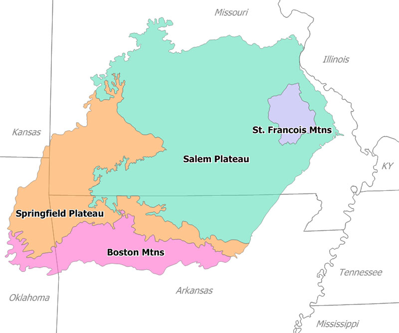
There are two mountain ranges in the Ozarks: the Boston Mountains of Arkansas and Oklahoma, as well as the St. Francois Mountains of Missouri. Wahzhazhe Summit (formerly known as Buffalo Lookout), is the highest point in the Ozarks at 2,561 feet (781 m), and is located in the Boston Mountains, in the westernmost part of Newton County, Arkansas, 6.2 miles (10.0 km) east of Boston, Madison County, Arkansas. Geologically, the area is a broad dome with the exposed core in the ancient St. Francois Mountains. The Ozarks cover nearly 47,000 square miles (120,000 km2), making it the most extensive highland region between the Appalachians and Rockies. Together with the Ouachita Mountains, the area is known as the U.S. Interior Highlands.
The Salem Plateau, named after Salem, Missouri, makes up the largest geologic area of the Ozarks. The second largest is the Springfield Plateau, named after Springfield, Missouri, nicknamed the "Queen City of the Ozarks". On the northern Ozark border are the cities of St. Louis and Columbia, Missouri. Significant Ozark cities in Arkansas include Fayetteville, Bentonville, Springdale, Eureka Springs, and Fort Smith. Branson, just north of the Arkansas–Missouri border, is a tourist destination where Ozark culture is popularized.
The toponym Ozarks may derive from an English-language adaptation of the French abbreviation aux Arcs (short for French: aux Arcansas, meaning "of/at/to the Arkansas (Quapaw) [plural]"). In the decades prior to the French and Indian War of 1754 to 1763, aux Arkansas referred to France's trading post at Arkansas Post, located in the wooded Arkansas Delta lowland area above the confluence of the Arkansas River with the Mississippi River.
Another possible etymological origin might be the French phrase aux arcs, meaning "[land] of the arches", in reference to the dozens of natural bridges formed by erosion and collapsed caves in the Ozark region. These include Clifty Hollow Natural Bridge (actually a series of arches) in Missouri, and Alum Cove in the Ozark–St. Francis National Forest.
By the early 20th century, the term "Ozarks" had entered common parlance.[need quotation to verify]
The Ozarks consist of five physiographic subregions: the Boston Mountains of north Arkansas and Cookson Hills of east Oklahoma; the Springfield Plateau of southwest Missouri, northeast Oklahoma, and northwest Arkansas and including Springfield, Joplin and Monett/Aurora in Missouri, Tahlequah in Oklahoma, and Fayetteville and Harrison in Arkansas; the White River Hills along the White River, including Branson and Mountain Home to Batesville; the Salem Plateau or Central Plateau, which includes a broad band across south central Missouri and north central Arkansas including the Lebanon, Salem and West Plains areas; the Courtois Hills of southeastern Missouri; the Osage-Gasconade Hills around the Lake of the Ozarks; the Saint Francois Mountains; and the Missouri River and Mississippi River border areas along the eastern and northeastern flanks.
Karst features such as springs, losing streams, sinkholes and caves are common in the limestones of the Springfield Plateau and abundant in the dolomite bedrock of the Salem Plateau and Boston Mountains. Missouri is known as "The Cave State" with over 7,300 recorded caves, second in number only to Tennessee. The majority of these caves are found in the Ozark counties. The Ozark Plateaus aquifer system affects groundwater movement in all areas except the igneous core of the St. Francois Mountains. Geographic features include limestone and dolomite glades, which are rocky, desert-like areas on hilltops. Kept open by periodic fires that limit growth of grasses and forbs in shallow soil, glades are home to collared lizards, tarantulas, scorpions, cacti and other species more typical of the Desert Southwest.
Hub AI
Ozarks AI simulator
(@Ozarks_simulator)
Ozarks
The Ozarks, also known as the Ozark Mountains, Ozark Highlands or Ozark Plateau, is a physiographic region in the U.S. states of Missouri, Arkansas, and Oklahoma, as well as a small area in the southeastern corner of Kansas. The Ozarks cover a significant portion of northern Arkansas and most of the southern half of Missouri, extending from Interstate 40 in central Arkansas to Interstate 70 in central Missouri.
There are two mountain ranges in the Ozarks: the Boston Mountains of Arkansas and Oklahoma, as well as the St. Francois Mountains of Missouri. Wahzhazhe Summit (formerly known as Buffalo Lookout), is the highest point in the Ozarks at 2,561 feet (781 m), and is located in the Boston Mountains, in the westernmost part of Newton County, Arkansas, 6.2 miles (10.0 km) east of Boston, Madison County, Arkansas. Geologically, the area is a broad dome with the exposed core in the ancient St. Francois Mountains. The Ozarks cover nearly 47,000 square miles (120,000 km2), making it the most extensive highland region between the Appalachians and Rockies. Together with the Ouachita Mountains, the area is known as the U.S. Interior Highlands.
The Salem Plateau, named after Salem, Missouri, makes up the largest geologic area of the Ozarks. The second largest is the Springfield Plateau, named after Springfield, Missouri, nicknamed the "Queen City of the Ozarks". On the northern Ozark border are the cities of St. Louis and Columbia, Missouri. Significant Ozark cities in Arkansas include Fayetteville, Bentonville, Springdale, Eureka Springs, and Fort Smith. Branson, just north of the Arkansas–Missouri border, is a tourist destination where Ozark culture is popularized.
The toponym Ozarks may derive from an English-language adaptation of the French abbreviation aux Arcs (short for French: aux Arcansas, meaning "of/at/to the Arkansas (Quapaw) [plural]"). In the decades prior to the French and Indian War of 1754 to 1763, aux Arkansas referred to France's trading post at Arkansas Post, located in the wooded Arkansas Delta lowland area above the confluence of the Arkansas River with the Mississippi River.
Another possible etymological origin might be the French phrase aux arcs, meaning "[land] of the arches", in reference to the dozens of natural bridges formed by erosion and collapsed caves in the Ozark region. These include Clifty Hollow Natural Bridge (actually a series of arches) in Missouri, and Alum Cove in the Ozark–St. Francis National Forest.
By the early 20th century, the term "Ozarks" had entered common parlance.[need quotation to verify]
The Ozarks consist of five physiographic subregions: the Boston Mountains of north Arkansas and Cookson Hills of east Oklahoma; the Springfield Plateau of southwest Missouri, northeast Oklahoma, and northwest Arkansas and including Springfield, Joplin and Monett/Aurora in Missouri, Tahlequah in Oklahoma, and Fayetteville and Harrison in Arkansas; the White River Hills along the White River, including Branson and Mountain Home to Batesville; the Salem Plateau or Central Plateau, which includes a broad band across south central Missouri and north central Arkansas including the Lebanon, Salem and West Plains areas; the Courtois Hills of southeastern Missouri; the Osage-Gasconade Hills around the Lake of the Ozarks; the Saint Francois Mountains; and the Missouri River and Mississippi River border areas along the eastern and northeastern flanks.
Karst features such as springs, losing streams, sinkholes and caves are common in the limestones of the Springfield Plateau and abundant in the dolomite bedrock of the Salem Plateau and Boston Mountains. Missouri is known as "The Cave State" with over 7,300 recorded caves, second in number only to Tennessee. The majority of these caves are found in the Ozark counties. The Ozark Plateaus aquifer system affects groundwater movement in all areas except the igneous core of the St. Francois Mountains. Geographic features include limestone and dolomite glades, which are rocky, desert-like areas on hilltops. Kept open by periodic fires that limit growth of grasses and forbs in shallow soil, glades are home to collared lizards, tarantulas, scorpions, cacti and other species more typical of the Desert Southwest.