Hubbry Logo
Postal codes in IsraelPostal codes in IsraelMain
Open search
Postal codes in Israel
Community hub
Postal codes in Israel
logo
8 pages, 0 posts
0 subscribers
Be the first to start a discussion here.
Postal codes in Israel
from Wikipedia

2-digit postcode areas Israel (defined through the first two postal code digits)

Postal codes in Israel (Hebrew: מיקוד, Mikud) are seven digit numeric postal codes in use in Israel. Each postal code corresponds to a mail carrier route or RR, thus, when the letters are sorted by the postal code, they are assigned to a specific carrier.

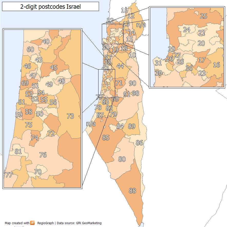
Postal codes are assigned by Israel Post generally from north to south, with the first two postal code digits being the postcode areas — thus, Metula in the north has 1029200 as its postal code, and Eilat in the south was assigned 88xxxxx. Jerusalem postal codes start with the digit 9, although this does not correspond with its geographical location.

Army unit postal codes start with a 0 and are not changed even if a unit is roaming.

History

[edit]

In March 2012, Israel Post announced a change to 7-digit postal codes, with an implementation date of 5 December 2012, but which was postponed to 1 February 2013. Officially the 5-digit codes remained valid until 31 January 2013, though they continue to be widely used.[1][2]

References

[edit]
[edit]
Revisions and contributorsEdit on WikipediaRead on Wikipedia
from Grokipedia
Postal codes in , known as mikud (מיקוד) in Hebrew, are a seven-digit numeric system administered by Israel Post, the country's national postal service, to facilitate efficient and delivery across its territory. Established in following the founding of the state, Israel Post manages a network of approximately 700 branches and handles both domestic and international mail, with postal codes playing a central role in routing items to specific carrier routes. The current seven-digit format, written as five digits followed by a space and two digits (e.g., 12345 67), was introduced on February 1, 2013, replacing the prior five-digit system to provide greater granularity for high-density areas and improve delivery accuracy. The first three digits of the code typically designate a geographic region or major city, such as 6 for central Israel including Tel Aviv, while the next two identify a specific post office, and the final two correspond to a precise mail carrier route or rural route (RR). This structure enables automated sorting and ensures mail reaches recipients even in remote or densely populated locations, with over 10 million possible combinations supporting Israel's population of approximately 10.1 million (as of 2025). Although the five-digit codes were officially phased out in 2013, they remain in limited use for legacy systems, and Israel Post provides an online tool for locating and verifying codes by address to aid users. In international , the follows the locality name without , and the is abbreviated as "ISR." Special considerations apply in disputed areas, where postal services may route through Israel Post despite separate systems in Palestinian territories.

Overview and Format

Structure of Codes

Israeli postal codes, known as mikud in Hebrew, follow a seven-digit numeric format, such as 1234567, which is commonly written with a space after the fifth digit for improved , as in 12345 67. This structure enables efficient by the , with each full code corresponding to a specific route or rural route (RR). The first two digits identify the postal district or region, allocated in a north-to-south sequence across . Codes beginning with 10–29 designate northern areas, 30–39 the region, 65 , 90–91 , and 88 southern locales such as . For example, the northernmost town of uses 1029200, while addresses in start with 880xxxx. Digits 3 through 5 denote sub-regions or delivery routes within the designated district, allowing for finer geographic segmentation. The final two digits pinpoint specific mail carrier routes or rural delivery paths, ensuring precise distribution to streets, buildings, or post office boxes. Certain codes maintain a static assignment regardless of location changes; notably, those starting with 0 are reserved for Israeli Defense Forces (IDF) units, providing consistent addressing for military mail. This seven-digit system was implemented in 2013 to replace the prior five-digit format, enhancing sorting capacity.

Usage in Domestic and International Mail

Postal codes are mandatory on all domestic mail in to ensure efficient routing to specific mail carriers, with their omission often resulting in processing delays at sorting facilities. The standard address format for domestic correspondence includes the recipient's name on the first line, the street name and building number on the second, the city or locality followed immediately by the seven-digit on the third, and "" (in English or Hebrew) on the final line, all aligned to the left and positioned in the lower right portion of the envelope. This format adheres to guidelines set by Post to standardize delivery. For international mail, the postal code must follow the city name without punctuation, with the country identifier "ISR" on the last line to comply with standards. An example address might read: John Doe, 10 HaYarkon Street, 6560311 , ISR, facilitating seamless cross-border processing. The seven-digit structure aids regional sorting by directing items to appropriate distribution centers before finer carrier assignment. Postal codes enable automated sorting at Israel Post facilities, where optical character recognition systems read and process codes to assign mail to individual routes, significantly enhancing throughput and accuracy. Although the seven-digit system became the official standard in , five-digit codes from the prior format remain accepted in practice, allowing legacy addresses to be handled without immediate rejection. Israel Post provides digital tools on its website, including an online address locator that validates and retrieves based on , , and number inputs, supporting accurate mailing for both domestic and international users.

Historical Development

Early Postal Coding System

The five-digit system, known as mikud in Hebrew, was introduced by Israel Post to enhance efficiency as the country's expanded rapidly due to and . This system aimed to mechanize the distribution process, reducing reliance on manual handling in post offices across . At the time, Israel Post managed all postal operations uniformly, with no separate coding mechanisms for occupied territories, ensuring a centralized approach to nationwide mail delivery. The format consisted of five numeric digits, where the first digit denoted broad geographic regions—such as 9 for and surrounding areas—while subsequent digits specified local post offices and delivery zones. For example, the code 94142 was assigned to certain neighborhoods in , facilitating routing from national hubs to specific branches. This structure allowed for approximately 100,000 unique combinations, sufficient for initial urban and rural coverage but aligned with the hierarchical sorting needs of the era. By the 1990s, the system had achieved widespread adoption, becoming standard for domestic addressing and integrated into everyday use by businesses and residents. However, its limitations became evident as urban areas expanded and mail volumes increased; the five-digit format lacked the required for precise carrier routes and sub-neighborhood deliveries, resulting in overload on manual sorting processes at local post offices. These shortcomings, including limited capacity for future growth compared to more advanced international systems, eventually prompted a transition to a seven-digit format in 2013.

Transition to Seven-Digit Codes

The transition to seven-digit postal codes in was announced by Israel Post in early 2012 and took effect on February 1, 2013, replacing the previous five-digit system. This shift expanded the number of possible unique codes from 100,000 to 10 million, providing greater capacity for future needs. The primary motivations for the change included accommodating Israel's rapid , which had increased from approximately 3.92 million in 1980 to over 8.08 million by 2013, and enabling more precise mail sorting and delivery routes through mechanized and computerized processes. The updated system adapted to urban expansion and improved overall efficiency and reliability in mail distribution, aligning with modern postal practices that support route-specific handling. For bulk mailings, the requirement extended to a 16-digit format, incorporating the seven-digit code plus a nine-digit distribution identifier to further enhance sorting precision and allow for up to one billion combinations. The rollout involved updating postal databases, integrating the new codes into and systems, and a phased adoption period during which both five- and seven-digit formats were temporarily accepted to facilitate the changeover. Effective February 1, 2013, the seven-digit system became mandatory for all official mail, though legacy five-digit codes continued to appear in informal or non-official contexts. This transition immediately supported more accurate delivery in densely populated areas and reduced sorting errors through automation.

Assignment and Regional Distribution

District-Based Assignment

Postal codes in Israel are assigned geographically in a north-to-south progression, with the first two digits indicating a central region that roughly corresponds to the country's six administrative to optimize and delivery . This sequencing ensures lower code prefixes for northern regions, facilitating processing at central hubs. The major regions receive distinct code ranges based on their latitudinal position: the Northern District uses 10xxxxxx to 29xxxxxx, the Haifa 30xxxxxx to 39xxxxxx, the Central District primarily 40xxxxxx to 49xxxxxx and 70xxxxxx to 74xxxxxx, the Tel Aviv 51xxxxxx to 67xxxxxx, the Jerusalem 90xxxxxx to 99xxxxxx, and the Southern District 75xxxxxx to 89xxxxxx. Jerusalem's higher-numbered codes (starting with 9) represent an exception to the strict north-south order, reflecting its unique status as a primary distribution hub. Assignment criteria prioritize municipal boundaries, population density, and post office locations to define delivery routes, with each code tied to a specific carrier path for precise routing. These assignments are updated periodically by Israel Post to reflect urban growth and settlement changes, ensuring alignment with infrastructure. Representative examples include codes in the 31xxxxxx range for suburbs such as and , extending the core delivery network. Similarly, 66xxxxxx codes cover parts of Tel Aviv-Yafo, including southern neighborhoods like . Management of the system is centralized through Israel Post's database, linking codes to administrative regions rather than strict political divisions, with public lookups available via an online tool.

Exceptions and Special Assignments

Postal codes for military units and bases of the Israel Defense Forces (IDF) begin with the digit 0, such as 01xxxxxx. These are designated for security-sensitive operations and remain unchanged even if a unit relocates, supporting and confidentiality. Jerusalem deviates from the standard north-to-south progression, with codes starting with 9 despite its central location. This prioritizes its role as a key distribution hub, handling high volume due to political, religious, and administrative importance. Dedicated codes are allocated for post office boxes (PO boxes) and institutional addresses, such as government offices and large organizations, not tied to physical streets. For example, certain codes within series like 9xxxxxx or others serve these non-geographic purposes, enabling centralized handling. In rural and remote areas, including kibbutzim and moshavim in the , the last digits incorporate extended sequences for sparse rural routes with low density. This allows efficient service to dispersed communities without unique codes for every site. Reassignments are infrequent, typically for reasons, especially , with details not publicly disclosed.

Coverage Across Territories

Application in Israel Proper

Postal codes are fully integrated into the operations of Israel Post, ensuring efficient mail distribution across undisputed Israeli territory. The seven-digit system, implemented since February 1, 2013, assigns unique codes to routes, facilitating automated sorting and delivery for the vast majority of addresses. This covers nearly the entire population within proper, which is approximately 9.7 million residents as of 2025 (excluding Israeli settlers in the ). The infrastructure supporting postal code application includes a network of approximately 700 postal branches and several regional sorting centers that rely on the codes for automated processing. Mail is routed through these facilities using and scanning tied to the postal code, enabling high-volume handling for domestic letters and parcels. Additionally, Israel Post offers a free lookup tool and mobile-accessible search features to help users verify and find accurate codes for addresses, promoting precise addressing practices. While not explicitly mandated by law for all domestic mail, postal codes are essential for reliable delivery, particularly for official correspondence and international shipments entering , where the seven-digit format is required to clear and ensure routing. Businesses handling bulk shipments are encouraged—and in practice required by service terms—to include postal codes to avoid delays or returns, aligning with Israel Post's operational standards established post-2013 transition. In high-density urban areas such as and , the challenge of address overlaps due to similar street names or building configurations is addressed through the granular nature of the seven-digit codes, where the final digits specify sub-routes or delivery segments. This design resolves potential ambiguities without needing additional geographic qualifiers, maintaining delivery accuracy amid population concentrations. As of recent estimates, Israel maintains over 13,000 unique active postal codes to serve its more than 9.7 million inhabitants in Israel proper, reflecting the system's scalability for nationwide coverage. These codes are assigned based on district regions for initial sorting, with finer granularity for local distribution.

Handling in Occupied Territories

Israel Post manages mail delivery exclusively to Israeli settlements in the , assigning them standard seven-digit postal codes as part of the Israeli system. For example, the settlement of Mechola in the northern uses the code 1093000. These codes facilitate domestic and international mail routing within Israel's postal network, treating settlements as extensions of Israeli territory for delivery purposes. Prior to the 2007 Hamas takeover in Gaza, Israel Post similarly oversaw mail services there, including to both Israeli settlements and Palestinian areas, under arrangements established after the 1995 Oslo I Accords, which transferred initial control of postal operations in Palestinian territories to the Palestinian Authority (PA) while retaining Israeli oversight for international transit. Delivery in these occupied territories faces significant logistical and security complications, often resulting in prolonged delays due to mandatory Israeli security inspections. Mail to settlements and, historically, Gaza undergoes rigorous checks at Israeli facilities, leading to frequent holds or returns if deemed suspicious. A notable instance occurred in , when released approximately 10 tonnes of accumulated mail—held for up to eight years—to the following a 2017 agreement with the PA aimed at reducing arbitrary seizures. These delays stem from broader security protocols, including scans for prohibited items, which can extend processing times by weeks or months, particularly for international parcels transiting through Israeli ports or borders. Coverage of Israeli postal codes in the occupied territories is limited to Israeli settlements, excluding Palestinian cities and villages, which has created persistent gaps in service uniformity. International mail addressed to Palestinian areas in the or must include explicit notations such as "West Bank" or "Gaza Strip" followed by "via Israel" to ensure proper routing through Israel Post, as these regions lack dedicated Israeli codes. Without such specifications, items risk seizure or misdirection due to ongoing territorial disputes, where Israel maintains authority over cross-border mail flows. The of the 1990s deferred final decisions on postal sovereignty, leaving international postal handling under Israeli control pending a comprehensive agreement, which has not materialized. This ambiguity has perpetuated seizures of mail lacking proper notations or perceived as violating security protocols. As of 2025, mail handling in the occupied territories remains a hybrid system, with Israel Post providing partial access for international deliveries to settlements while the PA operates its own postal network in Areas A and B of the using independent codes introduced in 2021. In November 2024, the PA launched a postcode service integrated with , covering sites across the and [Gaza Strip](/page/Gaza Strip) to improve location accuracy for postal and delivery services. This duality has improved local delivery in PA-controlled zones but continues to cause for cross-territory , where Israeli inspections still apply, leading to occasional backlogs and the need for dual addressing in mixed areas.

Palestinian Postal Code System

Origins and Implementation

On February 7, 2021, the Palestinian Authority's Ministry of Telecommunications and Digital Economy announced the launch of an independent postal code system to assert sovereignty over postal services in the occupied territories and mitigate disruptions caused by Israeli control over mail handling. This initiative aimed to address delays in parcel deliveries, particularly from international e-commerce platforms, where Israeli inspections and seizures had previously hindered efficient distribution to Palestinian areas under PA jurisdiction. By establishing a separate system, the PA sought to bypass these bottlenecks and enhance the reliability of postal operations within its administered regions. The rollout commenced in April 2021, initially focusing on the , where approximately half a million buildings were assigned codes prior to full implementation. Integration for Gaza was planned as part of the broader framework but faced delays due to the ongoing Israeli blockade restricting movement and services. The system is managed by Palestine Post, the national postal operator established in 1994 and operating independently from Israel Post, ensuring localized administration of mail sorting and delivery. In 2024, the system expanded significantly with the addition of postal codes to over 500 sites across the , including refugee camps, to improve coverage in underserved areas. A key development was the partnership with , announced on November 14, 2024, which integrated the codes into the platform for better visibility and navigation support in both the and . This expansion underscores the PA's efforts to strengthen digital infrastructure amid ongoing conflicts with Israeli postal handling in the territories.

Format and Integration with Services

The Palestinian postal code system employs an alphanumeric format consisting of the letter "P" followed by three digits representing the postal zone or sector, optionally extended by four additional alphanumeric characters for the final point of delivery, totaling up to eight characters. This structure, established by the Palestinian Authority (PA) in coordination with the , positions the code to the right of the locality name on envelopes, facilitating sorting and delivery within the postal network. The format draws from international standards but is tailored to the territorial divisions, with the initial three digits after "P" encoding geographic and administrative details. Assignment of these codes is linked to the 16 administrative governorates—11 in the and five in the —with the first digit after "P" denoting the broad region, and subsequent digits specifying sub-areas such as towns or locales. For instance, codes in the P100–P199 range cover areas in the and governorates, while P600–P699 apply to and , and P900–P999 are designated for districts. This hierarchical system ensures precise routing, with over 450 unique codes distributed across approximately 900 localities, prioritizing urban centers and expanding to rural sites as allows. Integration with digital services has advanced notably in 2024, when the PA's Ministry of Telecommunications and Digital Economy enabled postcode display on , allowing users in the and to retrieve codes for specific locations via the platform's . This enhancement supports postcode lookups for navigation and logistics, aligning Palestinian addressing with global mapping standards, including updates to thousands of codes in Gaza as of December 2024. Similarly, e-commerce providers like Amazon, which expanded free shipping to Palestinian territories in 2020, have since the 2021 code launch incorporated recognition of these codes, enabling direct PA-handled deliveries without additional fees when the PA code is included alongside the full address. All international parcels to PA territories must bear the Palestinian postal code and destination city to comply with customs protocols. In practice, these codes are mandatory for mail processed through the PA's , which handles domestic and international items to streamline operations and reduce interception risks at borders. In areas with mixed administration, such as near checkpoints, senders occasionally append Israeli codes alongside PA ones to expedite clearance, though official PA guidelines emphasize exclusive use of Palestinian formats for and efficiency. Representative examples include locales assigned P150–P199, such as P159 for Ad Duheisha Camp, and areas under P860–P890, like P860 for central districts. Coverage remains uneven, particularly in Gaza, where code assignment has progressed with digital integration, but full operational implementation faces challenges due to Hamas's control since 2007 and the Israeli blockade, including a temporary blanket ban on in that was lifted shortly after. While governorates benefit from fuller rollout, Gaza rely on assigned codes with limited PA oversight, complicating service reliability amid ongoing blockade-related delays.

References

Add your contribution
Related Hubs
User Avatar
No comments yet.