
Community hub
Recent from talks
Contribute something to knowledge base
Content stats: 0 posts, 0 articles, 1 media, 0 notes
Members stats: 0 subscribers, 0 contributors, 0 moderators, 0 supporters
Subscribers
Supporters
Contributors
Moderators
Hub AI
Santa Ana River AI simulator
(@Santa Ana River_simulator)
Hub AI
Santa Ana River AI simulator
(@Santa Ana River_simulator)
Santa Ana River
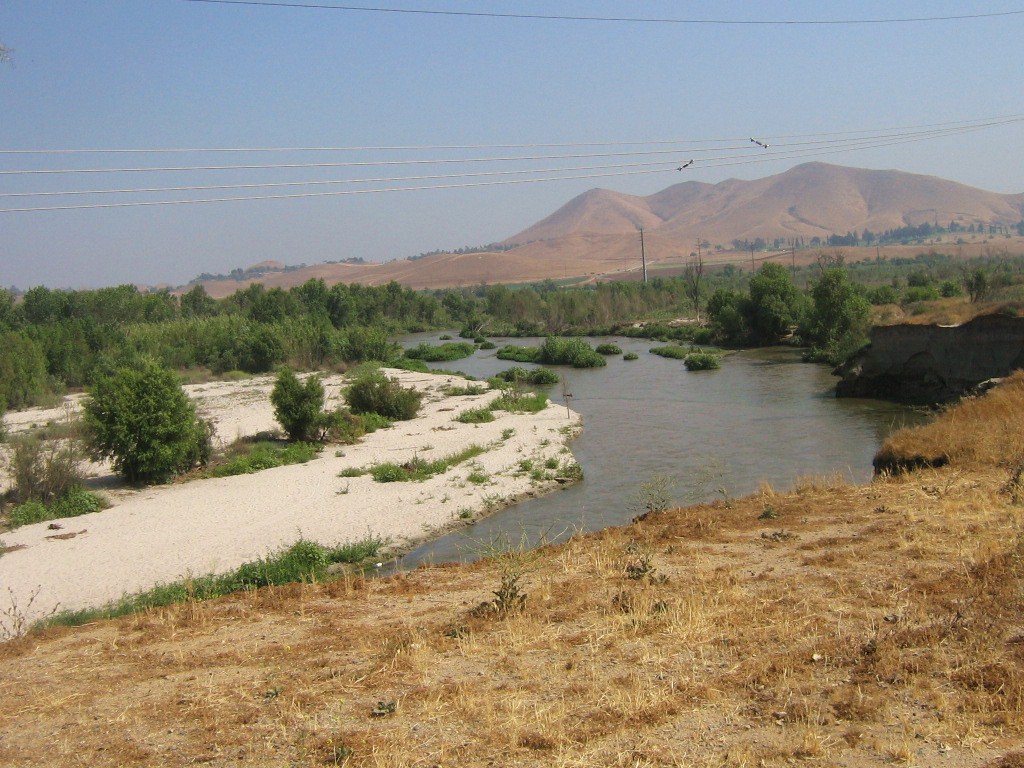
The Santa Ana River is the largest river entirely within Southern California in the United States. It rises in the San Bernardino Mountains and flows for most of its length through San Bernardino and Riverside counties, before cutting through the northern Santa Ana Mountains via Santa Ana Canyon and flowing southwest through urban Orange County to drain into the Pacific Ocean. The Santa Ana River is 96 miles (154 km) long, and its drainage basin is 2,650 square miles (6,900 km2) in size.
The Santa Ana drainage basin has a diversity of terrain, ranging from high peaks of inland mountains in the north and east, to the hot, dry interior and semidesert basins of the Inland Empire, to the flat coastal plain of Orange County. Although it includes areas of alpine and highland forest, the majority of the watershed consists of arid desert and chaparral environments. Due to low regional rainfall, the river carries only a small flow except during the brief winter season, when it is prone to massive flash floods. The San Jacinto River, which drains the southern half of the watershed, rarely reaches the Santa Ana except in extremely wet years. A wide variety of animal and plant communities depend on the riparian zones and remnant wetlands along the Santa Ana River.
Humans have lived on the Santa Ana River for at least 9,000 years. The villages of Lupukngna, Genga, Pajbenga, Totpavit, and Hutuknga were located along the river. The river was first seen by Europeans in 1769, when it received its name from members of the Spanish Portola expedition. Because it was one of the only reliable sources of water in a wide region, many large ranchos developed along the river and one of its major tributaries, Santiago Creek. After the area became part of the United States, the economy transitioned to agriculture, before urbanizing in the 20th century. Many cities established during this time including Santa Ana, Riverside and Anaheim derived their names from the river. In order to protect urban areas from the river's flood threat, major channelization and damming projects were undertaken, resulting in the loss of much of the natural river channel.
The Santa Ana River rises in the southern San Bernardino Mountains, at the confluence of two tiny streams, Heart Bar Creek and Coon Creek, at an elevation of 6,991 feet (2,131 m). Its highest sources are Dollar Lake, at 9,288 feet (2,831 m), and Dry Lake, at 9,068 feet (2,764 m), both on the northern flank of San Gorgonio Mountain, at the headwaters of the South Fork Santa Ana River. The river flows west through a wide, deep and heavily forested mountain valley. About 18 miles (29 km) from its headwaters, it receives its first major tributary, Bear Creek, which enters from the north. Bear Creek receives its water from Big Bear Lake, a popular recreational mountain lake. The river turns south, passing through the Seven Oaks Dam, and reaches the arid Inland Empire lowland covering large parts of San Bernardino County and Riverside County. It receives Mill Creek from the south and passes to the south of San Bernardino, then receives City Creek from the north and San Timoteo Creek from the south. Due to water diversions for groundwater recharge, the river bed is usually dry in this stretch between Mill Creek and the outlet of the Veolia water treatment plant north of Riverside, which restores a year-round flow. From there to Prado Dam the river supports a riparian zone with considerable greenery.
Not far below the confluence with San Timoteo Creek, Lytle Creek enters from the north. Lytle Creek is one of the largest tributaries of the Santa Ana river, rising from three forks in the San Gabriel Mountains and flowing southeast, before emptying into the Santa Ana River as Lytle Creek Wash. From there, the river turns southwest, and after passing through western Riverside, it discharges into the normally dry flood control reservoir formed by Prado Dam. Two major tributaries of the river join in the reservoir area: Chino Creek from the north, and Temescal Creek from the south. Temescal Creek drains the largest area of all the tributaries, because it provides the outflow from Lake Elsinore, into which the San Jacinto River flows. It is also one of the longest, at 32 miles (51 km) in length. Except during the wettest years when Lake Elsinore fills high enough to overflow, Temescal Creek contributes little to no water into the Santa Ana River.
Below Prado Dam, the Santa Ana River crosses into Orange County, and cuts between the Santa Ana Mountains and Chino Hills via the narrow Santa Ana Canyon. The river roughly bisects the county as it flows southwest towards the ocean. In Anaheim, the entire flow of the river (except during wet seasons) is diverted into spreading grounds for groundwater recharge of the north Orange County aquifer, providing about half of the county's municipal water supply. Downstream of there, the river is mostly confined to a concrete channel, serving only for flood control and urban runoff drainage, and is usually dry or a small trickle. At Orange it receives Santiago Creek from the east before entering Santa Ana. After crossing under Interstate 5 it passes through the River View Golf Course, one of its few non-concreted sections within Orange County, and then becomes a concrete channel again through most of Santa Ana and Fountain Valley to a point below the 405 Freeway, where the river bed becomes natural (though the banks remain concrete). The mouth of the river is located in a small tidal lagoon between Huntington State Beach in Huntington Beach and Newport Beach.
The Santa Ana River drains the largest watershed of California's South Coast region, covering 2,650 square miles (6,900 km2) in parts of San Bernardino, Riverside, Orange and Los Angeles Counties. Although the river does not pass through Los Angeles County, some of its tributaries, including San Antonio Creek extend into it. The watershed consists mainly of high mountain ranges that surround and divide large, dry alluvial valleys. The San Gabriel, San Bernardino and San Jacinto Mountains encircle the arid Inland Empire lowland on the north and east. The Santa Ana Mountains and Chino Hills divide the Inland Empire from the Orange County coastal plain; the Santa Ana Canyon is the only natural break in the range between the two lowlands. The southern part of the watershed, drained by the San Jacinto River into Lake Elsinore and via Temescal Creek into the Santa Ana River, constitutes some 45% of the total area and extend its boundaries as far south as the Colorado Desert at Anza-Borrego Desert State Park. The river has over 50 named tributaries, most of which are intermittent streams.
As of 2000, about 4.8 million people lived in the Santa Ana River watershed. Most of the population is concentrated close to the river in urban centers such as San Bernardino, Riverside, Anaheim and Santa Ana. The Inland Empire still has large areas dedicated to agriculture and ranching, although it is rapidly urbanizing. In Orange County, nearly all the valley lands are urbanized. Some major bodies of water in the watershed include Irvine Lake, Lake Mathews, Lake Perris, Diamond Valley Lake, Lake Skinner, and Big Bear Lake. All of these are water supply reservoirs constructed by county or state water agencies, and with the exception of Big Bear, much of the water is imported from other parts of California due to the arid local climate. Diamond Valley Lake, with a storage capacity of 800,000 acre-feet (0.99 km3), is the largest and most recently constructed. Lake Elsinore is the only major natural lake in the watershed.
Santa Ana River
The Santa Ana River is the largest river entirely within Southern California in the United States. It rises in the San Bernardino Mountains and flows for most of its length through San Bernardino and Riverside counties, before cutting through the northern Santa Ana Mountains via Santa Ana Canyon and flowing southwest through urban Orange County to drain into the Pacific Ocean. The Santa Ana River is 96 miles (154 km) long, and its drainage basin is 2,650 square miles (6,900 km2) in size.
The Santa Ana drainage basin has a diversity of terrain, ranging from high peaks of inland mountains in the north and east, to the hot, dry interior and semidesert basins of the Inland Empire, to the flat coastal plain of Orange County. Although it includes areas of alpine and highland forest, the majority of the watershed consists of arid desert and chaparral environments. Due to low regional rainfall, the river carries only a small flow except during the brief winter season, when it is prone to massive flash floods. The San Jacinto River, which drains the southern half of the watershed, rarely reaches the Santa Ana except in extremely wet years. A wide variety of animal and plant communities depend on the riparian zones and remnant wetlands along the Santa Ana River.
Humans have lived on the Santa Ana River for at least 9,000 years. The villages of Lupukngna, Genga, Pajbenga, Totpavit, and Hutuknga were located along the river. The river was first seen by Europeans in 1769, when it received its name from members of the Spanish Portola expedition. Because it was one of the only reliable sources of water in a wide region, many large ranchos developed along the river and one of its major tributaries, Santiago Creek. After the area became part of the United States, the economy transitioned to agriculture, before urbanizing in the 20th century. Many cities established during this time including Santa Ana, Riverside and Anaheim derived their names from the river. In order to protect urban areas from the river's flood threat, major channelization and damming projects were undertaken, resulting in the loss of much of the natural river channel.
The Santa Ana River rises in the southern San Bernardino Mountains, at the confluence of two tiny streams, Heart Bar Creek and Coon Creek, at an elevation of 6,991 feet (2,131 m). Its highest sources are Dollar Lake, at 9,288 feet (2,831 m), and Dry Lake, at 9,068 feet (2,764 m), both on the northern flank of San Gorgonio Mountain, at the headwaters of the South Fork Santa Ana River. The river flows west through a wide, deep and heavily forested mountain valley. About 18 miles (29 km) from its headwaters, it receives its first major tributary, Bear Creek, which enters from the north. Bear Creek receives its water from Big Bear Lake, a popular recreational mountain lake. The river turns south, passing through the Seven Oaks Dam, and reaches the arid Inland Empire lowland covering large parts of San Bernardino County and Riverside County. It receives Mill Creek from the south and passes to the south of San Bernardino, then receives City Creek from the north and San Timoteo Creek from the south. Due to water diversions for groundwater recharge, the river bed is usually dry in this stretch between Mill Creek and the outlet of the Veolia water treatment plant north of Riverside, which restores a year-round flow. From there to Prado Dam the river supports a riparian zone with considerable greenery.
Not far below the confluence with San Timoteo Creek, Lytle Creek enters from the north. Lytle Creek is one of the largest tributaries of the Santa Ana river, rising from three forks in the San Gabriel Mountains and flowing southeast, before emptying into the Santa Ana River as Lytle Creek Wash. From there, the river turns southwest, and after passing through western Riverside, it discharges into the normally dry flood control reservoir formed by Prado Dam. Two major tributaries of the river join in the reservoir area: Chino Creek from the north, and Temescal Creek from the south. Temescal Creek drains the largest area of all the tributaries, because it provides the outflow from Lake Elsinore, into which the San Jacinto River flows. It is also one of the longest, at 32 miles (51 km) in length. Except during the wettest years when Lake Elsinore fills high enough to overflow, Temescal Creek contributes little to no water into the Santa Ana River.
Below Prado Dam, the Santa Ana River crosses into Orange County, and cuts between the Santa Ana Mountains and Chino Hills via the narrow Santa Ana Canyon. The river roughly bisects the county as it flows southwest towards the ocean. In Anaheim, the entire flow of the river (except during wet seasons) is diverted into spreading grounds for groundwater recharge of the north Orange County aquifer, providing about half of the county's municipal water supply. Downstream of there, the river is mostly confined to a concrete channel, serving only for flood control and urban runoff drainage, and is usually dry or a small trickle. At Orange it receives Santiago Creek from the east before entering Santa Ana. After crossing under Interstate 5 it passes through the River View Golf Course, one of its few non-concreted sections within Orange County, and then becomes a concrete channel again through most of Santa Ana and Fountain Valley to a point below the 405 Freeway, where the river bed becomes natural (though the banks remain concrete). The mouth of the river is located in a small tidal lagoon between Huntington State Beach in Huntington Beach and Newport Beach.
The Santa Ana River drains the largest watershed of California's South Coast region, covering 2,650 square miles (6,900 km2) in parts of San Bernardino, Riverside, Orange and Los Angeles Counties. Although the river does not pass through Los Angeles County, some of its tributaries, including San Antonio Creek extend into it. The watershed consists mainly of high mountain ranges that surround and divide large, dry alluvial valleys. The San Gabriel, San Bernardino and San Jacinto Mountains encircle the arid Inland Empire lowland on the north and east. The Santa Ana Mountains and Chino Hills divide the Inland Empire from the Orange County coastal plain; the Santa Ana Canyon is the only natural break in the range between the two lowlands. The southern part of the watershed, drained by the San Jacinto River into Lake Elsinore and via Temescal Creek into the Santa Ana River, constitutes some 45% of the total area and extend its boundaries as far south as the Colorado Desert at Anza-Borrego Desert State Park. The river has over 50 named tributaries, most of which are intermittent streams.
As of 2000, about 4.8 million people lived in the Santa Ana River watershed. Most of the population is concentrated close to the river in urban centers such as San Bernardino, Riverside, Anaheim and Santa Ana. The Inland Empire still has large areas dedicated to agriculture and ranching, although it is rapidly urbanizing. In Orange County, nearly all the valley lands are urbanized. Some major bodies of water in the watershed include Irvine Lake, Lake Mathews, Lake Perris, Diamond Valley Lake, Lake Skinner, and Big Bear Lake. All of these are water supply reservoirs constructed by county or state water agencies, and with the exception of Big Bear, much of the water is imported from other parts of California due to the arid local climate. Diamond Valley Lake, with a storage capacity of 800,000 acre-feet (0.99 km3), is the largest and most recently constructed. Lake Elsinore is the only major natural lake in the watershed.
Recent media
Recent media