

Community hub
Recent from talks
Contribute something
Nothing was collected or created yet.
Sprint Expressway
View on Wikipedia
 | |
|---|---|
| SPRINT Expressway (System of Traffic Dispersal in Western Kuala Lumpur) | |
 | |
| Route information | |
| Maintained by Sistem Penyuraian Trafik KL Barat Sdn Bhd (Sprint) | |
| Length | 26.5 km (16.5 mi) Kerinchi Link: 11.5 km (7.1 mi) Damansara Link: 9.5 km (5.9 mi) Penchala Link: 5.5 km (3.4 mi) |
| Existed | 1999–present |
| History | Completed in 2004 |
| Component highways | Kerinchi Link (Kg. Kerinchi–Mont Kiara) Penchala Link (Jalan Duta–Sungai Penchala) Damansara Link (Semantan–Damansara Interchange) |
| Major junctions | |
Jalan Tuanku Abdul Halim (Jalan Duta) | |
| Location | |
| Country | Malaysia |
| Primary destinations | Damansara Utama, Damansara City, Petaling Jaya, Taman Tun Dr Ismail, Mont Kiara, Pusat Sains Negara, Sri Hartamas, Bangsar, Kuala Lumpur, Kerinchi, Jalan Duta |
| Highway system | |
E23 SPRINT Expressway (Malay: Sistem Penyuraian Trafik Kuala Lumpur Barat, English: System of Traffic Dispersal in Western Kuala Lumpur, Chinese: 吉隆坡西部疏散大道) is the main expressway network in Klang Valley, Malaysia. The 26.5 km (16.5 mi) expressway is divided into three sections: the Kerinchi Link, Damansara Link and Penchala Link. It is a three-lane dual carriageway that was built to disperse traffic from congested inner city roads and narrow residential streets leading into Kuala Lumpur from the western suburbs, including Petaling Jaya, Damansara, and surrounding areas. It is one of the busiest expressway during rush hour to and from the city centre.
Route background
[edit]Kerinchi Link
[edit]The 11.5 km (7.1 mi) sections from Seputeh Interchange at Federal Highway to NKVE at Jalan Duta. The Kilometre Zero of the Kerinchi Link's section is located at Mont Kiara-NKVE Interchange.
Damansara Link
[edit]The 9.5 km (5.9 mi) sections from Kayu Ara to Jalan Duta-Semantan Interchange. The Kilometre Zero of the Damansara Link's section is located at Kampung Kayu Ara in Petaling Jaya, Selangor.
Penchala Link
[edit]The 5.5 km (3.4 mi) sections from Damansara–Puchong Expressway at Penchala, Penchala Tunnel to Mont Kiara. The Kilometre Zero of the Penchala Link's section is located at Mont Kiara Interchange
History
[edit]The proposal to build the expressway was motivated by heavy traffic on Jalan Damansara. The concession for the expressway was awarded to Sistem Penyuraian Trafik KL Barat Sdn Bhd (SPRINT). On 23 October 1997, the concession agreement was signed between the Government of Malaysia and Sprint for the privatisation of the improvement, upgrading, design, construction, maintenance, operations, and management of the expressway.[citation needed]
A supplementary agreement was subsequently signed on 4 September 1998 to defer the construction of the Penchala Link. The concession period is for 33 years and commenced on the effective date on 15 December 1998. After this period, the toll collection will cease and the highways will be handed over to the government. Construction began in 1999, which included acquiring and upgrading several major roads, such as Jalan Damansara, Jalan Kayu Ara, Jalan Sri Hartamas, and Jalan Semantan. The Kerinchi Link and Damansara Link were opened in 2001, followed by the Penchala Link in 2004.[citation needed]
This expressway also featured its own toll collection system known as the "FasTrak". On 1 July 2004, the FasTrak electronic payment system was replaced by Touch 'n Go and Smart TAG electronic payment systems.[citation needed]
Pioneer roads
[edit]The construction of the SPRINT Expressway included acquiring and upgrading several major roads:
Kerinchi Link
[edit]| Roads | Sections |
|---|---|
| Jalan Sri Hartamas | Sri Hartamas |
| Jalan Bukit Kiara | Sri Hartamas–Bukit Kiara |
Damansara Link
[edit]| Roads | Sections |
|---|---|
| Jalan Semantan | Jalan Duta–Damansara Town Centre |
| Jalan Beringin | South side Jalan Johar–Semantan |
| Jalan Johar | Jalan Beringin–Jalan Damansara |
| Jalan Damansara | Damansara Town Centre–Damansara |
| Jalan Kayu Ara | Damansara–Kampung Kayu Ara |
Features
[edit]

The expressway has several notable features:
- Kerinchi Link, the first double deck carriageway in Malaysia.
- Penchala Tunnel, the widest road tunnel in Malaysia.
- The former Damansara Town Centre on Damansara Link as the "island" of separated carriageway.
- The 3 km toll-free road at Damansara Link as an alternative to residents who live in Sections 16 and 17 of Petaling Jaya
- The Speed Indicator Display (SID) at Kerinchi Link.
- The elevated Sungai Buloh–Kajang MRT line from Taman Tun Dr Ismail to Jalan Duta
Controversies and criticisms
[edit]Kerinchi Link at the Universiti Malaya site
[edit]The double-deck carriageway design of Kerinchi Link from Bukit Kiara Interchange Exit 2307 to Kerinchi Interchange Exit 2308 was made as a result of the early controversial issues during the development stage. The construction of the stretch took place at the border of Universiti Malaya, which meant that the construction could take up some of the university area, which sparked complaints. As a result, the expressway concessionaire Sprint came up with the idea of a double-deck carriageway which could reduce the land usage.
Damansara Town Centre as the "island" of separated carriageway
[edit]During the construction of the expressway, Jalan Semantan could not be widened to six lanes; consequently, the highway concessionaire took another main road at Damansara Town Centre for the Eastbound route, including Jalan Johar and Jalan Beringin. Damansara Town Centre became the "island" of the separated carriageways.
Unopened 2-lane off-ramp to Penchala Link at Sri Hartamas
[edit]Disputed ramp
[edit]When the expressway was opened to the traffic, the 530 m-long two-lane off-ramp from the Northbound direction of Kerinchi Link to Penchala Link at the Mont Kiara Interchange Exit 2303 could not be opened to traffic as a result of a land owner fencing the land which became a part of the ramp. The land owner's action has created difficulties among the residents of Bukit Kiara and Sri Hartamas, and even the highway concessionaire itself.
Meanwhile, the highway concessionaire has made a narrower temporary ramp to Penchala Link but according to the highway concessionaire, the temporary ramp is quite unsafe due to risks of being collided from behind. For the time being, the highway concessionaire is still negotiating with the land owner in order to open the two-lane ramp.[1]
Opening the ramp
[edit]At 3pm, 3 June 2010, Works Minister Datuk Shaziman Abu Mansor officially opened this disputed ramp.
Hitherto, road users living in the Mont Kiara and Sri Hartamas areas wanting to go to Jalan Duta, Duta–Ulu Klang Expressway (DUKE) and Penchala Link only had two lanes to use.
"This new ramp will ease the movement of almost 22,000 vehicles per day", he told reporters after opening the ramp.
Shaziman said the 50-metre ramp, which was delayed for seven years owing to problems related to acquisition of land, was completed in five months after the intervention by the Malaysian Prime Minister, Datuk Seri Najib Tun Razak, who had immediately approved about RM20 million for the acquisition of land.
The old SJKC Damansara near Sprint Expressway
[edit]The old SJKC Damansara has one block located at Section 17 near Jalan Damansara (now Sprint Expressway). However, on 26 January 2001, the school was moved from old block at Section 17 to the new smart school at PJU 3, near Tropicana Golf and Country Club following the instructions from federal government that it no longer provided a "conducive learning environment" because of traffic congestion and noise pollution from the neighbouring Sprint Expressway.
Tolls
[edit]The Sprint Expressway uses open toll systems.
Electronic Toll Collections (ETC)
[edit]As part of an initiative to facilitate faster transactions at the Kerinchi Link, Damansara Link and Penchala Link Toll Plazas, all toll transactions at three stretches toll plazas on the Sprint Expressway have been conducted electronically via Touch 'n Go cards or SmartTAGs since 2 March 2016.[2][3]
Toll rates
[edit](As of 15 October 2015)[4][5][6]
| Class | Type of vehicles | Rate (in Malaysian Ringgit (RM)) | ||
|---|---|---|---|---|
| Kerinchi Link | Damansara Link (NKVE and TTDI bound only) |
Penchala Link | ||
| 0 | Motorcycles, bicycles or vehicles with 2 or less wheels | Free | ||
| 1 | Vehicles with 2 axles and 3 or 4 wheels excluding taxis | RM2.50 | RM2.00 | RM3.00 |
| 2 | Vehicles with 2 axles and 5 or 6 wheels excluding buses | RM7.00 | RM4.00 | RM6.00 |
| 3 | Vehicles with 3 or more axles | RM10.50 | RM6.00 | RM9.00 |
| 4 | Taxis | RM1.80 | RM1.00 | RM1.50 |
| 5 | Buses | RM1.50 | RM1.00 | RM2.00 |
Toll names
[edit]| Abbreviation | Name |
|---|---|
| KCL | Kerinchi Link |
| DRL | Damansara Link |
| MTK | Mont Kiara |
| DMR | Damansara |
Junction lists
[edit]Legend:
- I/C - Interchange, I/S - Intersection, RSA - Rest and service area, OBR - Overhead bridge restaurant, R/R - Restaurant and rest plaza, L/B - Layby, V/P - Vista point, TN - tunnel, T/P - Toll plaza, BR - Bridge
Kerinchi Link (north–south)
[edit]The entire route is located in Federal Territory of Kuala Lumpur.
| km | Exit | Name | Destinations | Notes |
|---|---|---|---|---|
| 0.0 | 2301 | Jalan Duta I/C | Jalan Tuanku Abdul Halim (Jalan Duta) – Jalan Duta, City Centre, Segambut |
Directional T expressway interchange |
| 2302 | Mont Kiara I/C | Stacked interchange | ||
| Jalan Sri Hartamas 22 Exit | Jalan Sri Hartamas 22 – Desa Sri Hartamas | Mont Kiara bound | ||
| 2303 | Sri Hartamas I/C | Jalan 19/70A – Desa Sri Hartamas, Mont Kiara, Segambut, Sri Hartamas, Jalan Duta, Plaza Damas | Diamond interchange | |
| 3.0 | – | – | ||
| Jalan 48/70 Exit | Jalan 48/70 – Kiara View | Mont Kiara bound | ||
| 3.9 | 2305 | Pusat Sains Negara I/C | Persiaran Bukit Kiara – Bukit Kiara Equestrian & Country Resort, Pusat Sains Negara (National Science Centre), Bukit Damansara | Diamond interchange |
| 4.0 | – | – | ||
| Securities Commission Malaysia | Securities Commission Malaysia | Kerinchi bound | ||
| Royal Selangor Club | Royal Selangor Club | Mont Kiara bound | ||
| 2306 | INTAN I/C | Jalan Bukit Kiara 1 – Kuala Lumpur Golf & Country Club, Sime Darby Convention Centre, Institut Tadbiran Awam Negara (INTAN) (National Institute of Public Administration) Main Gate | Diamond interchange | |
| Jalan Bukit Kiara Exit | Jalan Bukit Kiara 1 – Bukit Kiara, Bukit Kiara Sports Complex, Kuala Lumpur Golf & Country Club | Mont Kiara bound | ||
| 2307 | Bukit Kiara I/C | Slip Roads to Jalan Dato' Abu Bakar – Section—until --, Section 17 commercial centre, Section 17 |
Stacked interchange | |
| Double deck carriageway | ||||
| Kerinchi Link Toll Plaza (Kerinchi Bound) | Touch 'n Go SmartTAG BET MyRFID | |||
| Kerinchi Link Toll Plaza (Mount Kiara Bound) | Touch 'n Go SmartTAG BET MyRFID | |||
| Double deck carriageway | ||||
| 2308 | Kerinchi I/C | KL Gateway-Universiti LRT station 5 |
Directional T expressway interchange Diamond interchange Stacked interchange | |
Damansara Link (west–east)
[edit]| States | District | km | Exit | Name | Destinations | Notes | Pictures |
|---|---|---|---|---|---|---|---|
| Petaling | 106 | Damansara-NKVE I/C | Closed tolled expressway Trumpet interchange | ||||
| T/P | Damansara Toll Plaza | Touch 'n Go Touch 'n Go SmartTAG SmartTAG MyRFID MyRFID SmartTAG SmartTAG Touch 'n Go Touch 'n Go | |||||
| Restricted Routes Heavy vehicles (laden and unladen heavy vehicles weighing 10,000 kg or more) are not allowed to enter the expressway Monday to Friday (except public holidays) 6:30 am to 9:30 am. Shah Alam - Jalan Duta (km 9.3 - km 31) | |||||||
| 0.0 | Kampung Sungai Kayu Ara | Kampung Sungai Kayu Ara | |||||
| 0.1 | Kayu Ara flyover Sungai Kayu Ara bridge |
Start/End of flyover | |||||
| 0.2 | 2309 | Kayu Ara flyover Kayu Ara Interchange |
Jalan SS 23/23 – Damansara Jaya, Atria Shopping Gallery | Half-diamond interchange | |||
| 0.3 | Kayu Ara flyover | Start/End of flyover | |||||
| 0.4 | Jalan SS 21/1 Exit | Jalan SS 21/1 – Damansara Utama | Junctions from NKVE only | ||||
| Jalan SS 22/11 Exit | Jalan SS 22/11 – Damansara Jaya | Junctions from Jalan Duta only | |||||
| 1.0 | 2310 | Damansara Utama I/C | Multi-level stacked diamond interchange | ||||
| Tropicana City Mall | Tropicana City Mall |
Parking ramp interchanges | |||||
| SS 20 Exit | Jalan Damansara – SS 20, Tropicana City Mall |
Eastbound | |||||
| BR | Sungai Penchala bridge | ||||||
| Bukit Kiara Muslim Cemetery | Bukit Kiara Muslim Cemetery |
Eastbound, For Muslims only | |||||
| 2311 | Section 17 I/C | Jalan 17/21 – Section 17 | Interchange | ||||
| 2312 | TTDI South I/C | Jalan Damansara – Taman Tun Dr. Ismail |
Interchange with ramp to Jalan Damansara | 
| |||
| 3.0 | L/B | Damansara Link Toll Plaza | Customer Service Centre Sprint operation office |
TTDI bound only | |||
| Damansara Link Toll Plaza (Plaza B = NKVE bound) | Touch 'n Go Touch 'n Go SmartTAG SmartTAG MyRFID | ||||||
| Jalan 17/1 Exit | Jalan 17/1 – Section 17, International Islamic University Malaysia (IIUM) (Petaling Jaya Campus) |
Junctions on the Eastin Hotel one way | |||||
| Damansara Link Toll Plaza (Plaza A = TTDI bound) | Touch 'n Go Touch 'n Go SmartTAG SmartTAG MyRFID | ||||||
| L/B | Petronas L/B | Jalan Duta bound | |||||
| Phileo Damansara MRT station | Phileo Damansara MRT station 9 | 
| |||||
| TTDI Bound Exit | Jalan Damansara – Taman Tun Dr. Ismail |
||||||
| Elevated U-Turn | Kuala Lumpur, Damansara Town Centre, Damansara City | From Section 17 slip roads (Jalan 16/11) to Kuala Lumpur via Damansara Link | |||||
| 4.0 | 2313 | Section 16 I/C | Kelab Golf Perkhidmatan Awam (KGPA), Section 17 Slip Roads (Jalan 16/11), Section 16 commercial centre, Section 16, Section 17 Jalan Dato' Abu Bakar – Jalan Universiti, Jalan Kemajuan, Universiti Malaya, Petaling Jaya |
Diamond interchange | |||
| 2307 | Bukit Kiara I/C | Slip Roads (Jalan 16/11) to Jalan Dato' Abu Bakar – Section—until --, Section 16 commercial centre, Section 16, Section 17 |
Stacked interchange | 
| |||
| Jalan Gegambir Exit | Jalan Gegambir – Universiti Malaya |
Junctions from Jalan Duta only | |||||
| Jalan Setiapuspa Exit | Jalan Setiapuspa – Taman Bukit Damansara | Junctions from Damansara only | |||||
| Jalan Medang Tanduk Exit | Jalan Medang Tanduk – Bukit Bandaraya | Junctions from Jalan Duta only | |||||
| 7.0 | – | – | |||||
| 2314 | Maarof I/C | Jalan Maarof – Bangsar, KL Sentral, Mid Valley City | Interchange | 
| |||
| Start/End of separated carriageway | |||||||
| Jalan Kasah Exit | Jalan Kasah – |
Junctions from Damansara only | |||||
| Pusat Bandar Damansara MRT station | P&R Pusat Bandar Damansara MRT station 9 | 
| |||||
| Jalan Johar Exit | Jalan Johar | Junctions from Jalan Duta only | |||||
| 2314A | Bukit Damansara I/C | Jalan Beringin/Jalan Johar – Damansara Heights, Damansara Town Centre, Damansara City, U-turn to Petaling Jaya | Interchange from Damansara only | ||||
| 2314B | I/C | Jalan Damanlela | Off ramp from Damansara only | ||||
| Damansara City Exit | Damansara City | Off ramp from Damansara only | |||||
| 2315D | I/C | Bangsar, Jalan Maarof, Taman Duta, HELP Residency |
Trumpet interchange from Jalan Duta only | ||||
| 2315C | I/C | Jalan Damansara – Galeria Sri Perdana, Medan Damansara, Bukit Damansara, Jalan Johar, Bangsar | Trumpet interchange from Jalan Duta only | ||||
| 2315A | Semantan I/C | Jalan Dungun/Jalan Beringin – U-turn to Kuala Lumpur |
Interchange | 
| |||
| Start/End of separated carriageway | |||||||
| Semantan MRT station | Semantan MRT station 9 | 
| |||||
| Jalan Damansara Endah Exit | Jalan Damansara Endah – ECM Libra Building |
Junctions from Jalan Duta only | 
| ||||
| Jalan Dungun Exit | Jalan Dungun – Wisma UN (United Nations Headquarters in Malaysia), Wisma I&P, HELP University |
Junctions from Damansara only | 
| ||||
| Changkat Semanatan Underpass Exit | Changkat Semanatan – Istana Negara (Gate 2), Suruhanjaya Koperasi Malaysia Headquarters, Wisma Chase Perdana | Trumpet interchange | 
| ||||
| Wisma Damansara | Wisma Damansara | From Damansara only | |||||
| 8.0 | |||||||
| Wisma ELM | HELP University (ELM Business School) |
From Damansara only |
| ||||
| Jalan Duta-Semantan I/C | Jalan Tuanku Abdul Halim (Jalan Duta) – Ipoh, Kuantan, Segambut, City Centre, Malaysian Houses of Parliament, Putra World Trade Centre (PWTC), Seremban | Trumpet interchange | 
| ||||
Penchala Link (west–east)
[edit]| States | District | km | Exit | Name | Destinations | Notes | Pictures |
|---|---|---|---|---|---|---|---|
| Petaling | 6.2 | 2304 | Penchala I/C | Jalan PJU 8/1 – Damansara Perdana, Desa Temuan Jalan PJU 7/9 – Mutiara Damansara, The Curve, IKANO Power Centre-IKEA |
Stacked expressway interchange | ||
| 2316 | DASH Highway I/C | Stacked expressway interchange | |||||
| 6.0 | – | – | |||||
| Petronas L/B | Eastbound | ||||||
| 5.0 | BR | TTDI North flyover Sungai Penchala bridge |
|||||
| 2317 | TTDI North flyover TTDI North I/C |
Jalan Datuk Sulaiman – Kampung Sungai Penchala, Taman Tun Dr. Ismail, Rasta @ TTDI |
Diamond interchange | ||||
| Eastbound Motorcycles only |
|||||||
| 4.0 | T/N | Penchala Tunnel | Maximum height: 5 m | Length: 0.7 km | 
| ||
| Motorcycle shelter points | Westbound Motorcycles only |
||||||
| Petronas L/B | Westbound | ||||||
| T/P | Mont Kiara Toll Plaza | Touch 'n Go Touch 'n Go SmartTAG SmartTAG MyRFID MyRFID SmartTAG SmartTAG Touch 'n Go Touch 'n Go | |||||
| 0.0 | 2302 | Mont Kiara flyover Mont Kiara I/C |
Stacked interchange | ||||
References
[edit]- ^ Missing link is the cause of Mont Kiara's daily crawl Archived 25 June 2009 at the Wayback Machine The Star, 22 June 2009
- ^ Chin, Graham (27 January 2016). "LDP and Sprint tolls to go fully cashless this year".
- ^ Lee, Jonathan (26 February 2016). "Cashless toll collection on KESAS, SPRINT, Guthrie, LEKAS and LATAR to begin on March 2, 2016".
- ^ "SPRINT Toll Fares". litrakgroup.com.my.
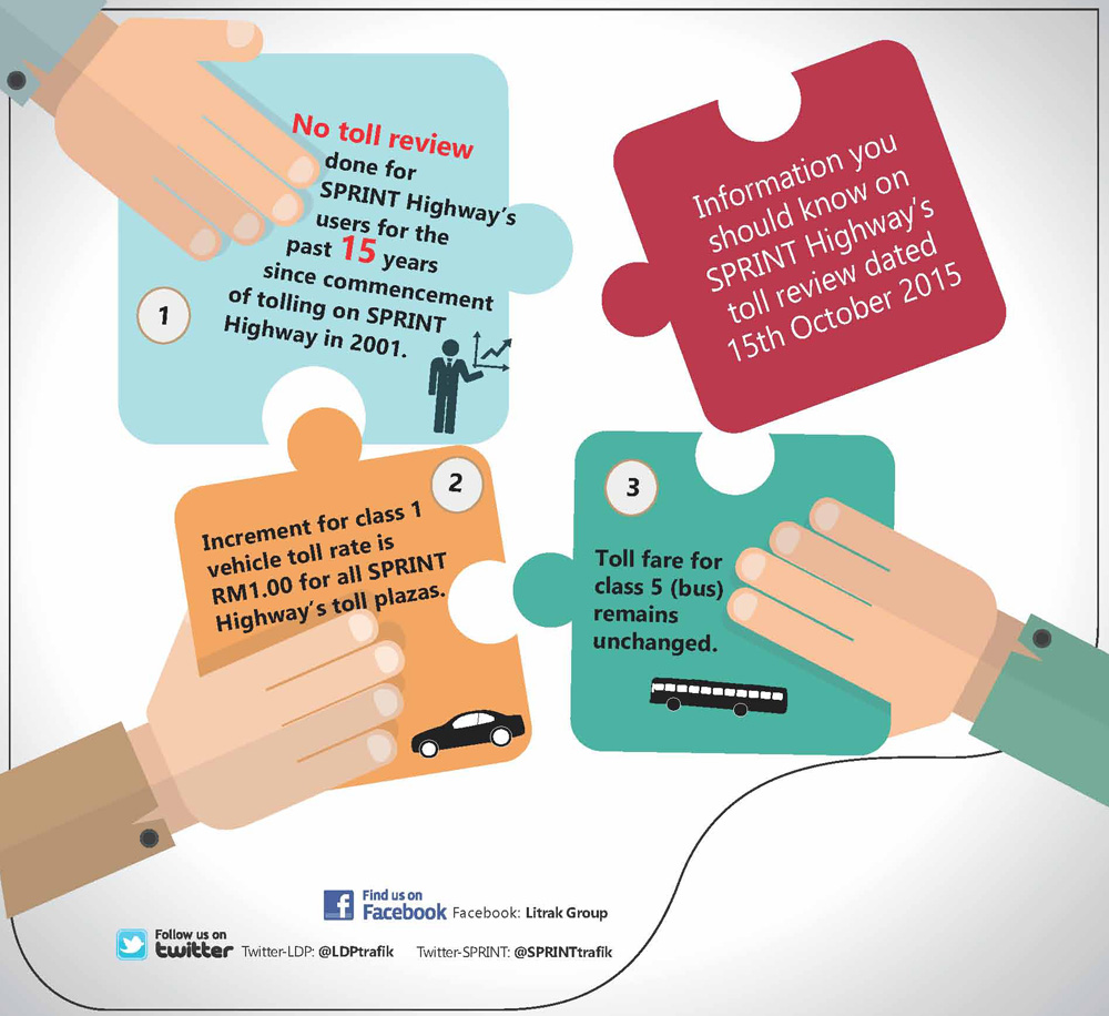
- ^ "Information you should know on SPRINT Highway's toll review dated 15th October 2015". litrakgroup.com.my.
- ^ Lim, Anthony (13 October 2015). "Sprint Expressway toll rates to go up on October 15 – Kerinchi Link, Penchala Link and Damansara Link".
External links
[edit]Sprint Expressway
View on GrokipediaRoute Description
Kerinchi Link
The Kerinchi Link constitutes the southern segment of the Sprint Expressway, extending approximately 11.5 km northward from the Kerinchi Interchange to the transition with the Damansara Link near the Mid Valley Megamall vicinity.[3] This alignment follows a primarily elevated viaduct structure, traversing urban terrain in southwestern Kuala Lumpur and facilitating seamless integration into the broader expressway network.[4] At its southern terminus, the Kerinchi Link interconnects with the Federal Highway (Route 2) via a complex three-tier Y-shaped interchange featuring double-deck viaducts, enabling efficient merging from southern arterial roads into the expressway.[4] The route passes adjacent to Universiti Malaya, providing localized access points that support academic and residential traffic flows without direct campus interchanges.[5] Further north, it approaches the Mid Valley area, where proximity to commercial hubs enhances connectivity for outbound dispersal. This segment plays a critical role in diverting vehicular volume from congested southern suburbs, such as those along the Federal Highway, toward central Kuala Lumpur destinations, thereby alleviating pressure on parallel urban roads.[1] Indirect linkages to the Middle Ring Road 2 (MRR2) occur through Federal Highway feeders, promoting regional traffic redistribution within the Klang Valley system.[6]Damansara Link
The Damansara Link forms the east-west core of the Sprint Expressway, spanning 9.5 kilometers from the Kayu Ara interchange at Kampung Kayu Ara in Petaling Jaya to the Jalan Duta-Semantan interchange near Semantan in Kuala Lumpur.[3] This segment traverses densely developed urban terrain, incorporating elevated structures over residential areas in Damansara Utama and Damansara Jaya to maintain traffic flow without obstructing ground-level access.[7] Key connections include ramps to Jalan Damansara, enabling integration with local arterials and facilitating entry from adjacent neighborhoods.[4] The route links to extensions of the SPRINT system, supporting continuous dispersal across the Klang Valley. By providing an alternative to surface roads, the Damansara Link functions as a primary bypass for congestion in central Damansara and Taman Tun Dr Ismail, diverting vehicles from overburdened paths like Jalan Damansara and Federal Highway segments.[8]Penchala Link
The Penchala Link constitutes the eastern segment of the Sprint Expressway, extending approximately 5.5 kilometers from the Penchala Interchange in the west to the Segambut Interchange in the east, thereby establishing a key west-east corridor within Kuala Lumpur's urban network.[3] This configuration integrates seamlessly with the broader Sprint system, which comprises the Kerinchi Link to the south and Damansara Link to the southwest, collectively forming a partial loop that encircles central Kuala Lumpur and facilitates circumferential traffic movement.[2] The link's alignment traverses densely developed suburban terrain, incorporating the 700-meter Penchala Tunnel—a twin-bore structure designed to navigate hilly topography and minimize surface disruption.[1] At its western terminus, the Penchala Link interconnects with the Damansara–Shah Alam Elevated Expressway (DASH), enabling efficient inbound and outbound flows from Shah Alam and western suburbs into the city.[9] To the east, it links to the DUKE Highway at Segambut, providing onward access to northern and northeastern routes, while offering proximity to upscale residential enclaves such as Sri Hartamas and Mont Kiara.[10] These linkages enhance suburban connectivity, supporting commuter access to commercial hubs and housing developments without funneling all volume through downtown arterials. As part of the Western Kuala Lumpur Traffic Dispersal Scheme, the Penchala Link plays a critical role in redistributing vehicular loads from congested inner-city roads toward peripheral northern suburbs, thereby mitigating peak-hour bottlenecks and promoting balanced urban mobility.[1] Its operational design, including three-lane dual carriageways, accommodates higher capacities for cross-town travel, contributing to the overall system's objective of easing central congestion through alternative peripheral pathways.[2] This dispersal function has been integral since the link's integration into the Sprint network, aiding in the management of growing metropolitan traffic volumes.[3]History
Planning and Pioneer Roads
The Sprint Expressway was conceptualized in the 1990s as a key component of the Malaysian government's Western Kuala Lumpur Traffic Dispersal Scheme, aimed at relieving chronic congestion on the Federal Highway and diverting traffic from overcrowded inner-city and residential roads in the Klang Valley. This initiative formed part of the broader Greater Kuala Lumpur Traffic Masterplan, which sought to establish a network of ring roads and radial expressways to enhance urban mobility and capacity in the rapidly growing western suburbs of the capital.[1][2] Planning efforts intensified in the mid-1990s, driven by escalating traffic volumes on routes like Jalan Damansara, where bottlenecks severely hampered access to central Kuala Lumpur. The scheme prioritized three interconnected links—Kerinchi, Damansara, and Penchala—to create a 26.5 km dual three-lane system linking major highways such as the Federal Highway, New Pantai Expressway, and North Klang Valley Expressway. Early alignments in the Kerinchi and Damansara areas were identified as precursors, with phased preparatory works enabling integration into the existing road network while minimizing disruption to dense urban development.[1] On October 23, 1997, the government awarded the concession to Sistem Penyuraian Trafik KL Barat Sdn Bhd (SPRINT), a private consortium tasked with financing, designing, and upgrading the route through toll revenues. This public-private partnership model involved key players like Gamuda Berhad, which contributed to route design and feasibility assessments to ensure technical viability amid challenging topography and land constraints. The arrangement emphasized self-sustaining toll-funded infrastructure to accelerate implementation without straining public budgets.[11][2]Construction and Development
The Sprint Expressway's development was formalized through a concession agreement signed on 23 October 1997 between the Malaysian government and Sistem Penyuraian Trafik KL Barat Sdn Bhd (SPRINT), with the effective date set for 15 December 1998.[1] A supplementary agreement on 4 September 1998 deferred construction of the Penchala Link to prioritize initial phases.[1] Principal works commenced shortly thereafter, encompassing upgrades to existing roads and new infrastructure across the 26.4 km, six-lane dual carriageway system. Construction proceeded in phases, with the Damansara Link and Kerinchi Link—the initial segments—completed and operationalized in 2001, marking the first double-decked carriageway in Malaysia within the Kerinchi section.[1] The Penchala Link followed, reaching completion in 2004 after addressing deferred elements.[1] [2] Contractor Gamuda Berhad handled critical components, including the integration of 13 interchanges to enhance urban connectivity. A primary engineering challenge involved the 700-meter twin-bore Penchala Tunnel, the widest highway tunnel in Malaysia at the time, constructed via the drill-and-blast method in geologically complex urban terrain reaching depths of up to 30 meters.[1] [2] This approach was necessitated by site constraints precluding tunnel boring machines, demanding precise rock stabilization and ventilation systems to mitigate risks in a densely populated area. The privatized concession model, reliant on toll-backed financing, expedited these phases by leveraging private capital and expertise, thereby averting substantial upfront public debt while achieving operational readiness within five years of the effective concession date.[1]Opening and Initial Operations
The Kerinchi Link and Damansara Link of the Sprint Expressway commenced operations in 2001, initiating the highway's role as a key dispersal network in western Kuala Lumpur. These sections were developed under a Build-Operate-Transfer (BOT) concession agreement signed on 23 October 1997, with an effective date of 15 December 1998, and managed by Sistem Penyuraian Trafik KL Barat Sdn Bhd, the concessionaire within the Litrak group.[1] The links provided six lanes of free-flow carriageway, connecting major urban areas and immediately serving as alternatives to overburdened routes like the New Klang Valley Expressway (NKVE).[1] Following construction completion, operational management transitioned to the concessionaire, focusing on toll collection and maintenance to support initial traffic dispersal. The opening alleviated pressure on inner-city roads by diverting vehicles from congested federal routes, though specific early traffic volume data remains limited in public records. The Penchala Link's addition in 2004 extended the network, but the 2001 inaugurations established the expressway's foundational connectivity.[1]
Design and Engineering Features
Structural and Technical Specifications
The Sprint Expressway comprises a 26.5 km six-lane dual carriageway configured as a free-flow highway, enabling uninterrupted traffic movement across its three links: Kerinchi, Damansara, and Penchala.[1][12] This design prioritizes high-capacity throughput by minimizing intersections and employing elevated viaducts where necessary, with the overall structure built to Malaysian Public Works Department standards for expressways, including reinforced concrete for bridges and pavements to withstand heavy urban loads.[3] Key structural elements include the 700-meter twin-bore Penchala Tunnel, engineered as the widest highway tunnel in Malaysia upon completion, featuring twin parallel bores for bidirectional flow and ventilation systems compliant with local safety norms.[1] The Kerinchi Link introduces Malaysia's inaugural double-decked carriageway section, stacking roadways vertically to optimize space in dense areas while maintaining structural integrity through post-tensioned concrete slabs.[1] Additionally, the route incorporates 10 pedestrian bridges constructed with steel and concrete to provide safe overpasses, reducing at-grade conflicts.[12] Engineering for efficiency emphasizes durability via asphalt surfacing on concrete bases, designed for repetitive heavy vehicle traffic, though specific material compositions like polymer-modified binders are not publicly detailed beyond standard Malaysian highway specifications.[3] The system lacks specialized earthquake-resistant features, aligning with Malaysia's low-seismic zoning under pre-2017 codes, which prioritize wind and flood resilience over seismic detailing. Noise mitigation, where implemented along edges, utilizes barriers to attenuate traffic sound, though comprehensive coverage is not uniformly specified.[13] Maintenance protocols focus on routine pavement resurfacing and structural inspections to sustain load-bearing capacity, supporting daily volumes that have historically exceeded design thresholds during peak urban demand.[1]Interchanges and Connectivity
The Sprint Expressway comprises 13 interchanges across its three constituent links, designed to integrate with radial and ring road networks in western Kuala Lumpur for efficient traffic dispersal.[2] These access points primarily utilize ramp systems, including directional and diamond configurations, to connect with major arterials while minimizing weaving conflicts.[3] The Kerinchi Link, oriented north-south over 11.5 km, features interchanges enabling linkage to the Federal Highway at Seputeh for southern access and to the New Klang Valley Expressway (NKVE, E1) at both Jalan Duta and Mont Kiara, with the latter serving as the link's reference kilometre zero.[3] This configuration supports bidirectional ramps to the NKVE, facilitating northward travel toward Ipoh and southward integration via the Federal Highway, which indirectly connects to the New Pantai Expressway (NPE, E10) near its southern terminus.[3] Intermediate ramps provide dispersal to urban locales such as Bangsar and Kampung Kerinchi, enhancing local connectivity without direct radial highway ties. The Damansara Link, spanning 9.5 km in an east-west alignment, originates at Kampung Kayu Ara (its kilometre zero) and terminates at the Jalan Duta-Semantan Interchange, incorporating ramps for access to Petaling Jaya suburbs and integration with surrounding surface roads.[3] Its western extensions link to the Lebuhraya Damansara-Puchong (LDP, E11) at Damansara Utama, promoting cross-traffic flow between central Kuala Lumpur and western suburbs.[14] The Penchala Link connects westward from Mont Kiara to Sungai Penchala, interfacing with the LDP at the Penchala Interchange via multi-level ramps that accommodate high-volume turns toward Bandar Utama and Mutiara Damansara.[14] This setup emphasizes seamless merging with the LDP's east-west corridor, bolstering overall network redundancy for commuters avoiding city-center bottlenecks.[15] Collectively, these interchanges prioritize integration with the NKVE for regional expressway access, the LDP for suburban loops, and local feeders via the Federal Highway, forming a dispersal skeleton that links isolated urban pockets to the national highway grid.[3]Ownership, Operation, and Tolls
Concession Agreement and Operator
The concession agreement for the Sprint Expressway was signed on 23 October 1997 between the Government of Malaysia and SPRINT Sdn Bhd, authorizing the private entity to improve, upgrade, operate, and maintain the highway under a 33-year term effective from 15 December 1998.[1] The Malaysian Highway Authority (LLM) serves as the regulatory body, monitoring compliance with concession terms including maintenance standards, toll adjustments, and handover provisions at expiry. SPRINT Sdn Bhd, the concessionaire, is operated by Litrak Infra Berhad, a subsidiary of Litrak Holdings Sdn Bhd, in which Gamuda Berhad holds a controlling interest through direct and indirect stakes exceeding 70%.[16][17] This privatized toll concession framework was designed to attract private capital and technical expertise for infrastructure expansion during Malaysia's 1990s economic boom, when public fiscal resources were stretched by competing national priorities such as industrialization and urban growth. By shifting financial risk and operational responsibility to concessionaires funded via user tolls, the model facilitated rapid development without immediate strain on government budgets, though it embedded long-term revenue streams for operators.[18] Government initiatives to abolish tolls on highways like Sprint, pledged in political manifestos since at least the 2018 elections, have encountered repeated delays as of 2025, primarily due to the prohibitive costs of compensating concessionaires for foregone revenues and assuming maintenance liabilities, projected in the billions of ringgit. Works Minister Datuk Seri Alexander Nanta Linggi noted that outright abolition would impose billions in payouts alongside ongoing road upkeep burdens previously covered by tolls, contrasting with more feasible short-term measures like hike deferrals funded by annual government subsidies exceeding RM500 million across multiple expressways. For Sprint and affiliated concessions under Gamuda-Litrak, this has manifested in stalled buyout talks, such as 2022 negotiations with state-linked investor Amanah Lebuhraya Rakyat (ALR), prioritizing rate freezes over termination amid fiscal prudence.[19][20][21]Toll Collection Systems and Rates
The Sprint Expressway operates an electronic toll collection (ETC) system featuring dedicated lanes for Touch 'n Go cards and SmartTAG transponders, enabling cashless payments and reducing wait times at plazas compared to manual collection methods.[22][23] These systems were standardized following the phase-out of the proprietary FasTrak in 2004, aligning with national ETC adoption to minimize congestion on urban routes.[24] Since August 2023, the expressway has incorporated open payment options, accepting contactless credit and debit cards at select lanes as part of a nationwide trial to further digitize tolling and accommodate users without dedicated transponders.[25] This expansion, extended into 2024 for highways including Sprint, supports RFID compatibility while maintaining interoperability with legacy ETC devices amid gradual system upgrades.[26][27] Toll rates, unchanged as of October 2025 following the postponement of scheduled increases under concession reviews, are segmented by vehicle class and plaza location, with revenues directed toward maintenance and operations without government subsidies.[28][1]| Vehicle Class | Description | Rate per Plaza (RM) |
|---|---|---|
| Class 1 | Car (2 axles, 3/4 wheels, excl. taxi) | 2.00–3.00 |
| Class 2 | Van (2 axles, 6 wheels) | 2.00–3.00 |