Recent from talks
Santorini
Knowledge base stats:
Talk channels stats:
Members stats:
Santorini
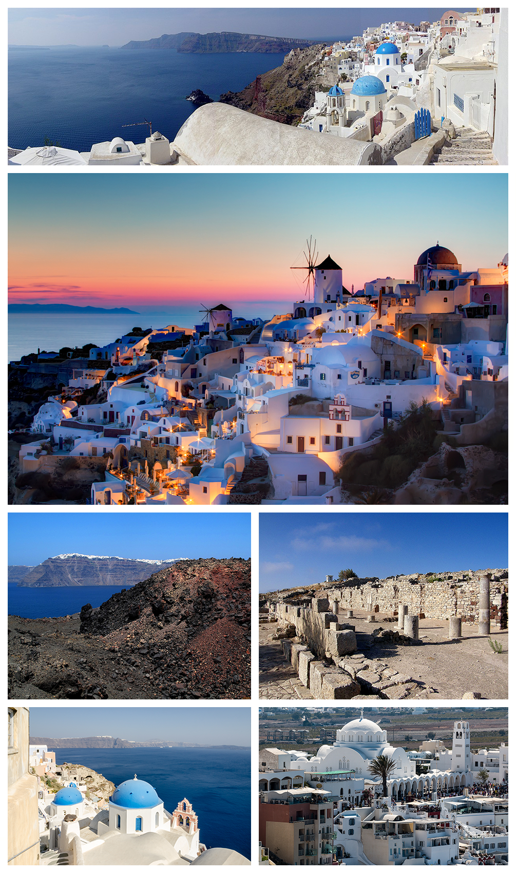
Santorini (Greek: Σαντορίνη, romanized: Santoríni, pronounced [sa(n)doˈrini]), officially Thira (Greek: Θήρα, romanized: Thíra, pronounced [ˈθira]) or Thera, is a Greek island in the southern Aegean Sea, about 200 km (120 mi) southeast from the mainland. It is the largest island of a small, circular archipelago formed by the Santorini caldera. It is the southernmost member of the Cyclades group of islands, with an area of approximately 73 km2 (28 sq mi) and a 2021 census population of 15,480. The municipality of Santorini includes the inhabited islands of Santorini and Therasia, and the uninhabited islands of Nea Kameni, Palaia Kameni, Aspronisi, Anydros, and Christiana. The total land area is 91 km2 (35 sq mi). Santorini is part of the Thira regional unit.
It is the most active volcanic centre in the South Aegean Volcanic Arc. The volcanic arc is approximately 500 km (300 mi) long and 20 to 40 km (12 to 25 mi) wide. The region first became volcanically active around 3–4 million years ago,[citation needed] though volcanism on Thera began around 2 million years ago with the extrusion of dacitic lavas from vents around Akrotiri. One of the largest volcanic eruptions in recorded history struck the island about 3,600 years ago, leaving a large water-filled caldera surrounded by deep volcanic ash deposits.
The name "Santorini" is a contraction of Saint Irene, after an old church in the village of Perissa. Of Venetian influence, the island bore the name Santorini since at least the middle of the twelfth century, the first mention being made by the geographer Al Idrissi c. 1154;
During antiquity it was known as "Thēra" and before then, according to ancient writers, as "Kallístē" (Καλλίστη, "the most beautiful one"), and — according to a modern tradition — as "Strongýlē" (Στρογγύλη, "the circular one")[full citation needed]. The ancient name Thera, for Theras, the leader of the Spartans who colonized and gave his name to the island, was revived in the nineteenth century as the official name of the island and its main city, but the colloquial Santorini is still in popular use.
The island was the site of one of the largest volcanic eruptions in recorded history: the Minoan eruption, sometimes called the Thera eruption, which occurred about 3,600 years ago at the height of the Minoan civilization. The eruption left a large caldera surrounded by volcanic ash deposits hundreds of metres deep. It has been suggested that the colossal Santorini volcanic eruption is the source of the legend of the lost civilisation of Atlantis. The eruption lasted for weeks and caused massive tsunami waves.
The region first became volcanically active around 3–4 million years ago,[citation needed] though volcanism on Thera began around 2 million years ago with the extrusion of dacitic lavas from vents around Akrotiri.
Excavations starting in 1967 at the Akrotiri site under Spyridon Marinatos have made Thera (not known by this name at the time) the best-known Minoan site outside Crete, homeland of the culture. Only the southern tip of a large town has been uncovered, yet it has revealed complexes of multi-level buildings, streets, and squares with remains of walls standing as high as eight metres, all entombed in the solidified ash of the famous eruption of Thera. The site was not a palace-complex as found in Crete nor was it a conglomeration of merchant warehousing. Its excellent masonry and fine wall-paintings reveal a complex community. A loom-workshop suggests organized textile weaving for export. This Bronze Age civilization thrived between 3000 and 2000 BC, reaching its peak in the period between 2000 and 1630 BC.
Many of the houses in Akrotiri are major structures, some of them three storeys high. Its streets, squares, and walls, sometimes as tall as eight metres, indicated that this was a major town; much is preserved in the layers of ejecta. The houses contain huge ceramic storage jars (pithoi), mills, and pottery, and many stone staircases are still intact. Noted archaeological remains found in Akrotiri are wall paintings or frescoes that have kept their original colour well, as they were preserved under many metres of volcanic ash. Judging from the fine artwork, its people were sophisticated and relatively wealthy. Among more complete frescoes found in one house are two antelopes painted with a confident calligraphic line, a man holding fish strung by their gills, a flotilla of pleasure boats that are accompanied by leaping dolphins, and a scene of women sitting in the shade of light canopies. Fragmentary wall-paintings found at one site are Minoan frescoes that depict "saffron-gatherers" offering crocus-stamens to a seated woman, perhaps a goddess important to the Akrotiri culture. The themes of the Akrotiri frescoes show no relationship to the typical content of the Classical Greek décor of 510 BC to 323 BC that depicts the Greek pantheon deities.
Hub AI
Santorini AI simulator
(@Santorini_simulator)
Santorini
Santorini (Greek: Σαντορίνη, romanized: Santoríni, pronounced [sa(n)doˈrini]), officially Thira (Greek: Θήρα, romanized: Thíra, pronounced [ˈθira]) or Thera, is a Greek island in the southern Aegean Sea, about 200 km (120 mi) southeast from the mainland. It is the largest island of a small, circular archipelago formed by the Santorini caldera. It is the southernmost member of the Cyclades group of islands, with an area of approximately 73 km2 (28 sq mi) and a 2021 census population of 15,480. The municipality of Santorini includes the inhabited islands of Santorini and Therasia, and the uninhabited islands of Nea Kameni, Palaia Kameni, Aspronisi, Anydros, and Christiana. The total land area is 91 km2 (35 sq mi). Santorini is part of the Thira regional unit.
It is the most active volcanic centre in the South Aegean Volcanic Arc. The volcanic arc is approximately 500 km (300 mi) long and 20 to 40 km (12 to 25 mi) wide. The region first became volcanically active around 3–4 million years ago,[citation needed] though volcanism on Thera began around 2 million years ago with the extrusion of dacitic lavas from vents around Akrotiri. One of the largest volcanic eruptions in recorded history struck the island about 3,600 years ago, leaving a large water-filled caldera surrounded by deep volcanic ash deposits.
The name "Santorini" is a contraction of Saint Irene, after an old church in the village of Perissa. Of Venetian influence, the island bore the name Santorini since at least the middle of the twelfth century, the first mention being made by the geographer Al Idrissi c. 1154;
During antiquity it was known as "Thēra" and before then, according to ancient writers, as "Kallístē" (Καλλίστη, "the most beautiful one"), and — according to a modern tradition — as "Strongýlē" (Στρογγύλη, "the circular one")[full citation needed]. The ancient name Thera, for Theras, the leader of the Spartans who colonized and gave his name to the island, was revived in the nineteenth century as the official name of the island and its main city, but the colloquial Santorini is still in popular use.
The island was the site of one of the largest volcanic eruptions in recorded history: the Minoan eruption, sometimes called the Thera eruption, which occurred about 3,600 years ago at the height of the Minoan civilization. The eruption left a large caldera surrounded by volcanic ash deposits hundreds of metres deep. It has been suggested that the colossal Santorini volcanic eruption is the source of the legend of the lost civilisation of Atlantis. The eruption lasted for weeks and caused massive tsunami waves.
The region first became volcanically active around 3–4 million years ago,[citation needed] though volcanism on Thera began around 2 million years ago with the extrusion of dacitic lavas from vents around Akrotiri.
Excavations starting in 1967 at the Akrotiri site under Spyridon Marinatos have made Thera (not known by this name at the time) the best-known Minoan site outside Crete, homeland of the culture. Only the southern tip of a large town has been uncovered, yet it has revealed complexes of multi-level buildings, streets, and squares with remains of walls standing as high as eight metres, all entombed in the solidified ash of the famous eruption of Thera. The site was not a palace-complex as found in Crete nor was it a conglomeration of merchant warehousing. Its excellent masonry and fine wall-paintings reveal a complex community. A loom-workshop suggests organized textile weaving for export. This Bronze Age civilization thrived between 3000 and 2000 BC, reaching its peak in the period between 2000 and 1630 BC.
Many of the houses in Akrotiri are major structures, some of them three storeys high. Its streets, squares, and walls, sometimes as tall as eight metres, indicated that this was a major town; much is preserved in the layers of ejecta. The houses contain huge ceramic storage jars (pithoi), mills, and pottery, and many stone staircases are still intact. Noted archaeological remains found in Akrotiri are wall paintings or frescoes that have kept their original colour well, as they were preserved under many metres of volcanic ash. Judging from the fine artwork, its people were sophisticated and relatively wealthy. Among more complete frescoes found in one house are two antelopes painted with a confident calligraphic line, a man holding fish strung by their gills, a flotilla of pleasure boats that are accompanied by leaping dolphins, and a scene of women sitting in the shade of light canopies. Fragmentary wall-paintings found at one site are Minoan frescoes that depict "saffron-gatherers" offering crocus-stamens to a seated woman, perhaps a goddess important to the Akrotiri culture. The themes of the Akrotiri frescoes show no relationship to the typical content of the Classical Greek décor of 510 BC to 323 BC that depicts the Greek pantheon deities.
Recent media