Hubbry Logo
Yamanote and ShitamachiYamanote and ShitamachiMain
Open search
Yamanote and Shitamachi
Community hub
Yamanote and Shitamachi
logo
8 pages, 0 posts
0 subscribers
Be the first to start a discussion here.
Yamanote and Shitamachi
from Wikipedia
Yamanote and Shitamachi today. Yamanote marked in red and Shitamachi in blue letters.

Yamanote (山の手; Japanese pronunciation: [ja.ma.no(ꜜ).te][1]) and Shitamachi (下町; [ɕi̥.ta.ma.tɕi][1]) are traditional names for two areas of Tokyo, Japan.

Yamanote refers to the affluent, upper-class areas of Tokyo west of the Imperial Palace.[2][3] While citizens once considered it as consisting of Hongo, Kōjimachi, Koishikawa, Ushigome, Yotsuya, Akasaka, Aoyama and Azabu in the Bunkyō, Chiyoda, Shinjuku, and Minato wards,[2] in popular conception, the area extended westwards to include the Nakano, Suginami, and Meguro wards after the Great Kanto Earthquake in 1923.[2]

Shitamachi is the traditional name for the area of Tokyo including today the Adachi, Arakawa, certain neighbourhoods in Chiyoda, Chūō, Edogawa, Katsushika, Kōtō, Sumida, and Taitō wards, the physically low part of the city along and east of the Sumida River, mostly consisted of commercial areas and chonin residential areas during the Edo period.[3][4]

The two regions have always been vaguely defined, as their identity was more based on culture and caste than on geography.[5] While Tokugawa vassals of the samurai caste (hatamoto and gokenin) lived in the hilly Yamanote, lower castes (merchants and artisans) lived in the marshy areas near the sea. This dual class and geographic division has remained strong through the centuries while evolving with the times and is still in common use today.[6] Indeed, the two terms are now used also in other parts of the country. The term Yamanote still indicates a higher social status, and Shitamachi a lower one, even though de facto this is not always true.[6]

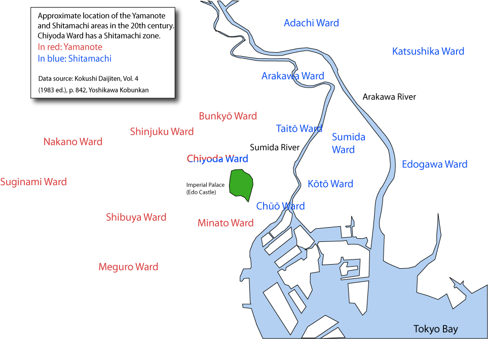
Both the Yamanote and the Shitamachi have grown gradually over the years, and the map above shows them as they are today.[7]

History of the terms

[edit]

When the Tokugawa regime moved its seat of power to Edo, it granted most of the solid hilly regions to the military aristocracy and their families for residences, in part taking advantage of its cooler summer.[5] Marshland around the mouths of the Sumida and Tone rivers, to the east of the castle, was filled in, with the flatlands that resulted becoming the area for merchants and craftsmen who supplied and worked for the aristocracy.[5] Thus, from the beginning of its existence, Tokyo (the former Edo) has been culturally and economically divided in two parts: the higher caste Yamanote, located on the hills of the Musashino Terrace, and the lower caste Shitamachi, literally "low town" or "low city", located next to the Sumida River.[5] Although neither of the two was ever an official name, both stuck and are still in use. Both words are used with the same meaning in other parts of the country too. The term "Yamanote" is also used for example in Hokkaido, Oita, Yokohama and Osaka.

There are several theories about the etymology of the term Yamanote, in addition to its hilly location. In the book Gofunai Bikō (御府内備考, Notes on Edo) it is said that Tokugawa Ietsuna's (1641–1680) younger brother Tsunashige was given two suburban residences, one in Umite (海手, Towards the sea) and another in Yamanote, so it is possible that the opposite of Yamanote was not Shitamachi, but Umite. However, with the progressive construction of landfills in the Sumida estuary and the urbanization of the area, gradually Shitamachi replaced Umite. The pairing of Yamanote - Shitamachi is well attested in records of the spoken language as early as 1650, and from that time appears often in documents and books. The warrior/merchant distinction between Yamanote and Shitamachi was also well established early on.[6]

Geography

[edit]
A view of Yamanote (above) and Shitamachi (below) by Utagawa Hiroshige. Nihonbashi is at the center of the map.

The terms' usage as geographic terms in modern times has changed. In Metropolis Magazine, translator and scholar Edward Seidensticker believes that the dividing line goes from Ginza to Shinjuku, and "north" and "south" are more accurate terms.[8] Seidensticker also describes how the economic and cultural centers have moved from Ginza and Nihonbashi to Shinjuku, Ikebukuro, Shibuya, and Shinagawa.[8]

Yamanote

[edit]
Hojo zaka, Minamiazabu, Minato, a typical Yamanote residential district

The extent of the early Yamanote cannot be defined exactly, but in Kyokutei Bakin's work Gendō Hōgen of 1818 (therefore during the Edo period) it is said that "Yotsuya, Aoyama, Ichigaya, Koishikawa and Hongō constitute Yamanote", and occupied therefore more or less a part each of today's Shinjuku, Bunkyo and Minato.[6]

The extent of the Yamanote changed little during the Meiji era. In 1894 it was described as consisting of Hongo, Koishikawa, Ushigome, Yotsuya, Akasaka, and Azabu. After the great earthquake of 1923 and again after the second world war, the Yamanote started to expand. As a result, today's Yamanote extends, in the eyes of the young, even further than Shinjuku, Bunkyo and Minato, to Suginami, Setagaya, Nakano, and even to Kichijōji or Denen-chōfu. What used to be the hilly area within the Yamanote line has now expanded west on the Musashino Plateau.[6] Bunkyo and Minato are generally considered Yamanote, however, some districts (Nezu and Sendagi in Bunkyo, and Shinbashi in Minato) are typically Shitamachi.

Today, the Yamanote Line is one of Tokyo's busiest and most important commuter rail lines. Originally thus named in 1909, when the line only connected Shinagawa to Akabane in the Yamanote area, the line was extended into its present loop in 1925, connecting Shitamachi areas like Ueno, Kanda, Yurakucho and Shinbashi as well. Tokyo Metropolitan Route 317 (東京都道317号, Tōkyō-todō Sanbyakujūnana-gō) is colloquially known as Yamate Dōri (山手通り, Yamate Dōri), or sometimes "Yamate Street", after the Yamanote region, as well.

Shitamachi

[edit]
Ginza shopping district in Shitamachi

The term originally indicated just the three areas of Kanda, Nihonbashi and Kyōbashi but, as the city grew, it came to cover also the areas mentioned above.[4] Shitamachi was the center of Edo, so much so that the two were often thought of as coterminous.[6] While Shitamachi was not in fact synonymous with Edo, there was originally a certain "conflation"[9] of the two terms, and those born in Shitamachi are typically considered true Edokko, children of Edo. This conflation is evident in the Edo period habit of saying "I am going to Edo" to mean going from the area around Fukagawa in Kōtō ward to anywhere east of the Sumida river.[6]

While the Yamanote grew west on the Musashino Plateau, in time the Shitamachi expanded east beyond the Arakawa river, and now includes the Chūō, Kōtō (Fukagawa), Sumida, and Taitō wards, plus part of Chiyoda ward.

The center of Ueno in Taitō lies at the heart of the old Shitamachi and still has several museums and a concert hall. Today the immediate area, due to its close proximity to a major transportation hub, retains high land value. The Shitamachi Museum in Ueno is dedicated to the area's way of life and culture, with models of old environments and buildings.[10] The Edo-Tokyo Museum, in Tokyo's Ryogoku district, also has exhibits on Shitamachi.

Bunkyo and Minato are generally considered Yamanote, however, Nezu and Sendagi in eastern Bunkyo, and Shinbashi in northeastern Minato are typical Shitamachi districts.

List of districts

[edit]

Wards with both Yamanote and Shitamachi districts

[edit]

All Shitamachi districts

[edit]

All Yamanote districts

[edit]
  • Shibuya ward (after the Great Kanto Earthquake)
  • Shinjuku ward
  • Nakano ward (after the Second World War)
  • Suginami ward (after the Second World War)
  • Meguro ward (after the Second World War)
[edit]

The distinction between the two areas has been called "one of the most fundamental social, subcultural, and geographic demarcations in contemporary Tokyo."[11] Generally speaking, the term Yamanote has a connotation of "distant and cold, if rich and trendy", whereas "Shitamachi people are deemed honest, forthright and reliable".[12] These differences encompass speech, community, profession and appearance.

Speech

[edit]

The modern Japanese word yamanote kotoba (山の手言葉) meaning "dialect of the Yamanote", takes its name from the region.[3] It is characterized by a relative lack of regional inflections, by a well-developed set of honorifics (keigo), and by linguistic influences from Western Japan.[13] After the Meiji Restoration it became the standard language spoken in public schools and therefore the basis of modern Japanese (hyōjungo), which is spoken all over the country.[3] The Yamanote accent is now considered to be standard Japanese, "making the shitamachi man a speaker of a dialect".[14] The origins of the difference arise from the presence of daimyōs and their vassals, and the continuous influx of soldiers from the provinces.[6]

Phrases such as shitamachi kotoba (下町言葉) meaning "Shitamachi dialect", and shitamachifū (下町風) meaning "Shitamachi style"[3] are still in use, and refer to certain characteristics and roughness in Shitamachi speech. The lack of distinction between the two phonemes hi and shi (so that hitotsu ("one)" is pronounced shitotsu) is typical of the Shitamachi kotoba.[3] Another characteristic trait is the pronunciation of the sound -ai as for example in wakaranai (I don't know or I don't understand) or -oi as in osoi (slow) as -ee (wakaranee or osee).[13] The use of either is still considered very low-class and rough. Shitamachi speakers are also supposedly less apt to use the elaborate word forms more characteristic of Yamanote Japanese.[15]

Yamanote kotoba and Shitamachi kotoba together form the so-called Tōkyō-go (東京語, language or dialect of Tokyo) which, because of its influences from Western Japan, is a linguistic island within the Kantō region.[13]

Profession

[edit]

The division between samurai and merchant has carried on into the modern day. Shitamachi is associated with petty entrepreneurs,[9] restaurant owners, small shop-owners and workshops, while Yamanote suggests the business executive, and the office worker.[16]

Attitude

[edit]

Until World War II, the Shitamachi people did not give "a damn about tomorrow".[17] Older locals were proud of not having gone far from the neighborhood. The March 1945 bombing of Tokyo wiped out the Shitamachi area and one hundred thousand lives.[17] The development associated to the 1964 Summer Olympics and the Tokyo Metropolitan Expressway further eroded the alley lifestyle. In spite of this, the Shitamachi mindset still values living for the moment and present pleasures. Clinging to something is unfashionable and one should be ready to weather disaster and start over.[17]

The Shitamachi boom

[edit]

Alongside the long drive for modernisation that had characterised Japan's post-restoration history, Shitamachi was marginalised for the larger part of the 20th century. In the words of one sociologist[who?], "it was increasingly confined to a defensive position, guarding old traditions and old social norms".[14] After a long period of post-war economic decline, in the 1980s a "Shitamachi boom" emerged, with increased interest in and celebration of Shitamachi culture and history, in particular that of the Edo Period.[9] Shitamachi culture is thus depicted as more authentic and traditional (while Yamanote Tokyo is the present and future),[9] and its valorisation has been described as a refuge from the rapid modernisation of the economic boom years.[18] Popular television dramas, comedy and documentary now "rarefy an often idealised notion of the Edokko, with the same intensity and nostalgia afforded an endangered species".[19]

References

[edit]
Revisions and contributorsEdit on WikipediaRead on Wikipedia
from Grokipedia

Yamanote and Shitamachi constitute the longstanding geographical, social, and cultural bifurcation of , dating to the when the city, then known as , divided into the elevated western highlands of Yamanote—home to residences and administrative elites—and the lowland eastern plains of Shitamachi, populated by merchants, artisans, and laborers engaged in commerce near the and .
This divide, literally translating to "mountain hand" for Yamanote and "under city" or "low town" for Shitamachi, reflected not only but also class structures, with Yamanote fostering a refined, hierarchical influenced by culture and later Western modernization, while Shitamachi nurtured a vibrant, communal spirit rooted in trade guilds, festivals, and resilient urban folk traditions.
Over centuries, including through Meiji-era reforms and post-World War II reconstruction, these identities endured socioeconomically, with Yamanote areas like and evolving into affluent, office-centric hubs for professionals, contrasting Shitamachi districts such as and Yanaka, which preserved artisan workshops, narrow alleys, and a sense of historical continuity amid ongoing economic pressures.
The Yamanote railway loop, established in the early , later symbolically encircled central but reinforced the perceptual boundary, underscoring persistent cultural markers like variations, architectural styles, and community practices that distinguish the two realms despite urban integration.

Etymology and Historical Origins

Origins of the Terms

The term Yamanote (山の手), literally translating to "mountain side" or "hand of the mountain," derives from the elevated, hilly terrain west and northwest of in the city of (modern ), where the land rises 10–20 meters above the surrounding plains due to Musashino Plateau formations. This nomenclature emerged during the (1603–1868), as the developed the area for residences and estates, distinguishing it topographically from lower districts; the "hand" evokes the sloping edges extending from higher ground toward the urban core. Early under the shogunate reinforced this division, with Yamanote's ridges providing natural drainage and defensibility, contrasting flood-prone lowlands. Shitamachi (下町), meaning "under town" or "low city" (shita denoting "below" and machi "town"), originated to describe the flat, alluvial eastern districts below the elevation of , encompassing marshy, riverine zones along the and that were vulnerable to tidal surges and inundation. These areas, developed from the early for guilds, artisans, and housing as Edo's population swelled to over one million by 1720, were explicitly defined in opposition to Yamanote, with records from the period referencing shitamachi as all wards lower than the castle precincts. The term's usage solidified amid frequent floods—such as the 1657 fire and subsequent deluges—that highlighted the topographic vulnerability, prompting earthen embankments but preserving the designation for the eastern commercial heart. Both terms crystallized in the mid-Edo period as Edo's matured, reflecting not only physiographic realities—plateau terraces versus sedimentary basins—but also initial by the bakufu for administrative control, with Yamanote allocated for military elites and Shitamachi for economic activity under strict sumptuary laws. While primarily geographical in origin, their persistence post-1868 underscores enduring spatial logic amid modernization, though boundaries blurred with infrastructure like the 1885 Yamanote rail precursor. No single document records the absolute first invocation, but Edo-era gazetteers and flood chronicles from the 1700s routinely employ them to delineate flood risk and .

Edo Period Foundations and Class Divisions

The foundations of the Yamanote and Shitamachi divisions trace to the early 17th century, when Tokugawa Ieyasu established the shogunate in Edo in 1603, transforming the former fishing village into Japan's de facto capital and a meticulously planned urban center centered on Edo Castle. This planning involved spatial segregation aligned with the rigid shi-no-ko-sho class system—samurai (shi), farmers (no), artisans (ko), and merchants (sho)—which placed samurai at the apex and merchants at the base despite the latter's growing economic influence. The shogunate allocated the elevated western districts, known as Yamanote or "mountain side," for samurai residences and daimyo mansions, while designating the lowland eastern areas, termed Shitamachi or "under the city," for chōnin (townspeople including merchants and craftsmen). This class-based division was deliberate, aimed at maintaining by physically separating the warrior elite from the potentially disruptive commercial classes, thereby preventing alliances that could challenge shogunal authority. Yamanote encompassed hilly terrain west of the castle, featuring spacious estates in areas like Hongo, Koishikawa, Ushigome, and Akasaka, equipped with advanced infrastructure such as working sewage systems and gardens, as exemplified by the Koishikawa Botanical Gardens established in 1684 under . In contrast, Shitamachi's flat, flood-prone eastern zones around —where a key bridge was constructed in 1603—and the housed dense neighborhoods of narrow, unpaved streets focused on trade and craftsmanship, lacking comparable sanitation. Enforced through policies like , which required to alternate residence in and leave families as hostages, the system concentrated elite power in Yamanote, with and near the moats and higher-ranking officials in outer estates. Merchants in Shitamachi, though legally inferior, amassed wealth via commerce along routes like the Tōkaidō, patronizing arts and entertainment in controlled districts such as , yet remained spatially and socially subordinate to uphold the Confucian-inspired hierarchy. These foundations persisted until the in 1868, embedding enduring cultural distinctions between the austere, status-conscious Yamanote and the vibrant, communal Shitamachi.

Geographical and Topographical Features

Yamanote's Elevated Terrain and Layout

The Yamanote district encompasses the higher terrain of Tokyo's Musashino Plateau, a diluvial upland formation that rises 10-20 meters above the adjacent coastal lowlands of Shitamachi. This elevated plateau, part of the broader Kanto Plain's eastern edge, features undulating hills and gentle slopes averaging 20-40 meters above , contributing to better natural drainage and lower susceptibility to flooding compared to the alluvial plains eastward. During the Edo period (1603-1868), the Yamanote's topography shaped urban layout, with residences and estates strategically placed on the hills west and north of , which occupied a defensible at approximately 10-15 meters . The area's rolling terrain facilitated a radial pattern of roads and residential zones radiating from the castle, emphasizing defensive advantages and class-based segregation, as the higher, drier ground contrasted with the marshy, flood-prone Shitamachi lowlands allocated to merchants and artisans. In the , the railway, fully operational by 1925, delineates much of the historical boundary, encircling the elevated inner districts with a 34.5-kilometer loop that traverses varying elevations—from a low of 2.9 meters at on the southeastern fringe to a high of 39.2 meters at in the west. This layout reflects the plateau's subtle topography, where stations like those in and sit amid hilly contours that continue to influence residential density and urban development patterns.

Shitamachi's Lowland and Riverine Characteristics

Shitamachi encompasses the lowland districts of eastern Tokyo, formed on alluvial plains with elevations generally ranging from near sea level to approximately 5 meters above it, contrasting sharply with the elevated Yamanote plateau to the west. This flat terrain originated from sedimentary deposits in river deltas and coastal marshes, rendering the soil soft and compressible, which has historically amplified risks from subsidence and seismic liquefaction. Parts of the region lie below mean tide level, increasing susceptibility to tidal influences and requiring extensive levees and pumping systems for drainage. The area's riverine character is defined by a dense network of waterways, including the , Arakawa River, and numerous canals, which traverse the lowlands and connect to . These rivers facilitated Edo-period commerce and urban expansion but also channeled floodwaters during typhoons and heavy rains, with the flat impeding natural drainage and leading to widespread inundation. Historical records document recurrent disasters, such as the 1910 Arakawa River flooding that devastated low-lying neighborhoods and spurred the engineering of the Arakawa Floodway from 1911 to 1924 as a dedicated overflow channel to mitigate overflows into Sumida River basins. This combination of low elevation and riverine hydrology has shaped Shitamachi's vulnerability, with modern hazard assessments identifying high flood risks along these waterways, particularly in districts like those surrounding the Arakawa and Sumida, where inundation depths could exceed 5 meters in extreme scenarios without interventions like super levees and underground reservoirs. Despite post-war and subsidence countermeasures, the underlying continues to influence , emphasizing elevated infrastructure and flood barriers in these persistent lowland zones.

Socioeconomic and Cultural Distinctions

Historical Occupational and Class Structures

During the (1603–1868), the Yamanote region—comprising elevated western districts of (present-day )—served primarily as the residential domain of the class, including high-ranking lords and their retainers. These elites occupied expansive yashiki mansions on hilltops, which accounted for roughly 70% of the city's land allocation, underscoring their political dominance and administrative roles in governance and military oversight under the . Samurai pursuits centered on bureaucratic duties, Confucian scholarship, and ritualized martial training, with limited engagement in commerce due to legal prohibitions on profit-seeking. In stark contrast, Shitamachi encompassed the marshy eastern lowlands, densely populated by (townspeople), who formed the economic backbone through mercantile and artisanal occupations. Merchants handled wholesale and retail trade in commodities like , textiles, and via guilds (kabunakama), while artisans operated workshops for crafts such as dyeing, metalworking, and woodworking, often clustered in machi-bugyō-administered wards. This area, limited to about 16% of urban land, fostered vibrant commercial hubs like , where laborers and petty entrepreneurs supported daily necessities amid frequent floods and fires. The spatial divide reinforced the shi-nō-kō-shō hierarchy, positioning (shi) as the privileged stratum in Yamanote despite their stipends often lagging behind wealth accumulation, while artisans (kō) and merchants (shō)—deemed socially inferior—thrived economically in Shitamachi through adaptive . Sumptuary laws and residential segregation maintained class boundaries, though covert merchant financing of samurai debts blurred lines by the late era. This structure persisted until the in 1868, which dismantled feudal domains and initiated socioeconomic mobility.

Linguistic and Dialectal Differences

The Shitamachi dialect, often termed Edo-ben, emerged among the merchant and artisan classes in Edo-period Tokyo's lowland districts, preserving phonetic and prosodic traits distinct from the more refined speech of the samurai-dominated Yamanote highlands. In contrast, the Yamanote dialect, spoken by upper-class residents, influenced the development of hyōjungo (standard Japanese) during the Meiji period (1868–1912), when educators and officials prioritized its polished intonation and conservative features for . This divergence reflects historical class divisions, with Shitamachi speech evoking a working-class vitality through quicker rhythms and contractions, while Yamanote forms emphasized clarity and formality suited to bureaucratic contexts. A primary distinction lies in pitch accent patterns, where Shitamachi flattens or shifts accents on common words compared to Yamanote. For instance, "saka" (slope) receives low-high pitch in Yamanote (accent on "ka") but high-low in Shitamachi (accent on "sa"); similarly, "sushi" accents on "shi" in Yamanote versus "su" in Shitamachi. Other examples include "Bandō" (with initial accent in Yamanote but accentless in Shitamachi) and "asahi" (accent on first mora in Yamanote). Shitamachi also merges certain phonemes absent in standard Japanese, such as reduced distinctions in vowels or consonants, contributing to its colloquial, "bouncing" prosody described in linguistic analyses as less elongated than Yamanote's measured delivery. These traits persist in media portrayals of Edokko (Edo natives), though urbanization has diluted both dialects since the postwar era. Grammatical and lexical variances further underscore the divide, with Shitamachi favoring contractions like "janai" pronounced rapidly and pronouns such as "anta" (informal "you") over standard forms, evoking a direct, earthy tone tied to merchant banter. Yamanote, by comparison, integrates more honorifics (keigo) and Western-influenced phrasing from Meiji-era elites, aligning closely with hyōjungo's emphasis on politeness hierarchies. Despite convergence under mass media and migration, Shitamachi features remain markers of regional identity in eastern wards like , while Yamanote's standard alignment dominates and . Linguistic studies note that these differences, rooted in Edo , influence contemporary perceptions, with Shitamachi speech often stereotyped as vibrant yet "vulgar" relative to Yamanote's perceived elegance.

Attitudinal and Social Behavioral Contrasts

Residents of Shitamachi areas are traditionally characterized as possessing a forthright and communal temperament, often described in sociological accounts as hot-tempered, extravagant, and sentimental, reflecting the merchant class heritage of and emotional expressiveness. In contrast, Yamanote inhabitants are stereotyped as cooler, thriftier, and more reserved, aligning with the historical and elite influences emphasizing restraint and self-control. These attitudinal differences manifest in everyday social interactions, where Shitamachi behaviors prioritize group harmony through direct communication and neighborhood solidarity, as seen in higher participation rates in local associations and festivals. Social network studies reveal quantifiable behavioral contrasts, with Shitamachi neighborhoods exhibiting denser, more homogeneous and greater reliance on local kin and neighbors for support, fostering attitudes of mutual reliance and lower . Yamanote districts, however, display sparser networks dominated by workplace and transient connections, correlating with behaviors oriented toward privacy, , and reduced involvement, as residents prioritize professional mobility over rooted local bonds. Linguistic patterns reinforce these traits: Shitamachi speech tends toward rough, direct forms evoking earthiness and candor, while Yamanote variants favor refined , underscoring a cultural preference for subtlety over bluntness. In contemporary , these contrasts influence attitudes toward urban change, with Shitamachi residents showing greater resistance to through preservationist behaviors and sentimental attachment to traditional practices, such as matsurizukuri (festival organization) that strengthens communal identity. Yamanote behaviors, by comparison, adapt more readily to modernization, evidenced by higher acceptance of high-rise developments and cosmopolitan lifestyles that value over . Such differences persist despite socioeconomic convergence post-1945, as empirical surveys of neighborhood attitudes indicate Shitamachi's enduring emphasis on interpersonal warmth and reliability against Yamanote's focus on personal achievement and detachment.

Economic Trajectories Post-Meiji Restoration

Following the in 1868, Tokyo's Yamanote region, previously dominated by estates, underwent repurposing as administrative and elite residential zones, with former lands allocated to government offices and new bureaucratic classes. The abolition of stipends by 1876 accelerated this shift, as displaced warriors transitioned into or professional roles, fostering a concentration of middle-class from the 1890s onward, characterized by one-family homes for officials and professionals. Yamanote's elevated terrain supported orderly , including early integration via the Yamanote Line's initial segments from 1885, which enhanced accessibility for affluent commuters and spurred finance and business hubs like . In contrast, Shitamachi's lowland areas, rooted in merchant and artisan economies, absorbed the brunt of early industrialization, with factories proliferating east of the due to riverine access for transport and labor-intensive operations. By 1890, had only six factories employing over 300 workers, primarily in textiles and machinery, but numbers surged by 1897 as state-linked military production in districts like Koishikawa expanded, alongside private ventures in proletarianizing zones. Shitamachi's reflected this trajectory, comprising two-thirds of 's residents by 1903 and 60% by 1920 when the city's total exceeded 2 million, with tenements housing influxes of industrial workers amid poor sanitation and flood risks. These divergences solidified socioeconomic divides: Yamanote evolved toward service-oriented bourgeois enclaves, exemplified by developments like Mitsubishi's Londontown (1892–1905), while Shitamachi's boomed during in the Keihin corridor, entrenching working-class with associated slums and . Despite shared modernization pressures, Shitamachi retained mercantile elements like the (opened 1886), blending tradition with nascent consumer growth, whereas Yamanote's trajectory prioritized exclusivity over . By the Taisho era (1912–1926), these patterns yielded persistent income and occupational disparities, with Yamanote's professional demographics contrasting Shitamachi's manual labor base.

Modern Districts and Boundaries

Wards Exhibiting Hybrid Traits

Several wards among 's 23 special wards exhibit hybrid traits, blending the elevated , refined culture, and associated with Yamanote with the lowland , merchant heritage, and communal ethos of Shitamachi. This mixing arises from historical urban expansions, post-earthquake reconstructions, and geographical positions that straddle the and Musashino Plateau divide, leading to neighborhoods with dual identities. Taito Ward exemplifies hybrid characteristics, encompassing the elevated Ueno district with its parks, museums, and imperial associations—hallmarks of Yamanote—alongside the adjacent Asakusa area, a historic Shitamachi hub of temples, festivals, and artisan trades dating to the . Ueno's development as a cultural enclave in the , including the establishment of the in 1872, contrasts with Asakusa's preservation of traditional wooden architecture and street-level commerce, fostering a ward where modern institutions coexist with pre-Meiji merchant districts. This duality persists in local dialects and social attitudes, with Ueno residents often displaying reserved demeanor while Asakusa maintains outgoing, community-oriented behaviors. Bunkyo Ward similarly displays divided traits, with its eastern neighborhoods of Nezu and Sendagi retaining Shitamachi features such as narrow alleys, historic temples like Nezu Shrine (founded in 1704), and a working-class residential fabric resistant to postwar high-rise development. In contrast, the western Hongo area embodies Yamanote qualities through its hilly terrain, prestigious universities like the (established 1877), and affluent housing that attracted samurai descendants post-Edo. This internal contrast, evident in land prices—Hongo averaging higher elevation and values—reflects Bunkyo's role as a transitional zone, where Shitamachi's borders Yamanote's intellectual and elite enclaves. Chiyoda Ward further illustrates hybridization, particularly through its Kanda district, a Shitamachi remnant with over 150 shrines and old-book markets tracing to the , juxtaposed against the ward's central Yamanote-like zones around the Imperial Palace, featuring wide boulevards and government offices developed after the 1868 . Kanda's annual festivals and dense, low-rise commercial streets preserve merchant-class traditions, while surrounding areas exhibit the spatial openness and status markers of upper-class districts, resulting in a ward population mix that includes both traditional artisans and high-income professionals as of 2020 census data.

Exclusively Shitamachi-Dominated Areas

The exclusively Shitamachi-dominated areas in contemporary are primarily the Adachi, Edogawa, and wards, located on the northeastern and eastern fringes of the 23 special wards, where lowland topography and historical working-class settlement patterns persist without substantial integration of Yamanote-style elite or commercial developments. These districts feature flat, alluvial terrain prone to flooding historically, with narrow streets, wooden townhouses, and community-oriented neighborhoods that evoke Edo-period merchant culture, contrasting with the high-rise density and globalized commerce of hybrid central zones. Population densities here average around 10,000–15,000 residents per square kilometer, supporting stock dominated by single-family homes and small apartments, fostering a socioeconomic profile of blue-collar workers and small business owners rather than corporate elites. Adachi Ward, Tokyo's northernmost special ward covering 53.25 square kilometers, exemplifies unadulterated Shitamachi traits through its riverside communities along the Arakawa and local industries like and logistics, with minimal upscale redevelopment as of 2023. Its crime rate remains low despite outdated perceptions, and cultural markers include annual festivals such as the Nishi-Arai Daishi Fire Festival, drawing on traditional communal rituals dating to the . Similarly, Edogawa Ward, spanning 49.9 square kilometers in the east with proximity to , retains Shitamachi essence in areas like Higashi-Koiwa, where prewar architecture and wet markets predominate, supported by a median household income roughly 20% below Tokyo's average in 2020 census data. Katsushika Ward, at 34.8 square kilometers, stands out for neighborhoods like Shibamata, immortalized in 1960s films depicting quintessential Shitamachi life, featuring sites such as Taishakuten Temple (established 1629) and persistent use of the local variant among older residents. These wards' resistance to stems from post-1945 that preserved residential zoning amid industrial decline, resulting in 2022 land prices averaging ¥200,000–¥300,000 per square meter—far below Yamanote equivalents—while community ties manifest in high participation rates in neighborhood associations (jichikai), exceeding 80% in surveyed districts. Despite urban pressures, these areas uphold causal continuity from Edo-era stratification, prioritizing empirical localism over imposed modernization.

Exclusively Yamanote-Dominated Areas

Minato Ward exemplifies an exclusively Yamanote-dominated area, featuring hilly topography and upscale neighborhoods such as , , and Akasaka, which host numerous foreign embassies, , and high-end residential developments. This ward's modern character stems from post-Meiji era expansion into the western highlands, avoiding the merchant-class heritage of eastern Shitamachi districts, with land prices averaging over 2 million yen per square meter in prime areas as of 2023. Shibuya Ward represents another core Yamanote enclave, centered around its namesake station and encompassing vibrant commercial hubs like the and trendy districts such as and Omotesando. Predominantly elevated and focused on youth-oriented fashion, , and corporate offices, it lacks the traditional wooden or festival-oriented community structures typical of Shitamachi, instead prioritizing high-density skyscrapers and global retail chains that reflect Yamanote's cosmopolitan evolution. Shinjuku Ward, with its western portions forming a quintessential Yamanote zone, includes in the subcenter and entertainment districts like Kabukicho, but maintains an overall affluent, office-driven profile on elevated land. Unlike hybrid central wards, Shinjuku's Yamanote areas feature minimal historical lowland influences, boasting some of Tokyo's highest office vacancy premiums and residential exclusivity, with redevelopment projects emphasizing vertical urbanism since the . These wards collectively underscore Yamanote dominance through consistent metrics: higher average elevations (20-50 meters above ), elevated property values (often exceeding 1.5 million yen per square meter citywide averages), and a demographic skew toward professionals and expatriates, as opposed to the working-class roots persisting in eastern districts. Their boundaries align with the traditional west-of-palace demarcation, ensuring no overlap with Shitamachi's riverine, traits.

Cultural Persistence and Revival

Postwar Decline and the 1980s Shitamachi Boom

Following , Shitamachi districts experienced significant physical and economic deterioration, exacerbated by extensive that razed much of Tokyo's traditional wooden and narrow lanes, particularly in the low-lying eastern wards. Reconstruction efforts prioritized rapid and development, including high-rise buildings and modern amenities, which eroded the area's historical merchant and artisan character as commercial power shifted westward toward Yamanote's emerging corporate and affluent zones. The 1950s–1970s high-growth era further marginalized Shitamachi's small-scale industries and tenement housing amid population influxes and events like the 1964 Tokyo Olympics, which spurred and displaced longstanding communities. By the late 1970s, amid broader postwar economic stagnation in traditional sectors, Shitamachi faced a cultural nadir with fading dialects, festivals, and crafts overshadowed by homogenized urban expansion. This decline prompted preservation initiatives, culminating in the 1980 opening of the Shitamachi Museum in , which reconstructed Edo-period merchant houses, tenements, and daily life artifacts to document and revive downtown Tokyo's heritage for future generations. The museum's establishment ignited a "Shitamachi boom," fostering nostalgia through media portrayals in films and literature that romanticized the area's communal spirit and resilience. The boom accelerated in the late amid Japan's bubble economy, which boosted tourism to preserved Shitamachi enclaves like those around , drawing visitors to experience authentic street foods, shops, and festivals amid fears of irreversible modernization. This revival emphasized Shitamachi's role as a to Yamanote's sterility, celebrating its egalitarian ethos and artisanal traditions, though critics noted selective idealization that overlooked ongoing socioeconomic challenges like aging populations and retail decline. By decade's end, the phenomenon had embedded Shitamachi imagery in national identity, sustaining museums, tours, and cultural events despite economic shifts. In contemporary Tokyo, the Yamanote-Shitamachi dichotomy endures as a foundational element of urban identity, symbolizing a tension between cosmopolitan modernity and nostalgic tradition, with Shitamachi often invoked as the "authentic" heart of the city in public discourse and media. This framing positions Yamanote districts like and as emblems of globalized progress and economic dynamism, housing corporate headquarters and attracting international talent, while Shitamachi areas such as and evoke Edo-period communalism and resilience against postwar reconstruction. Surveys of Tokyo residents indicate that over 60% associate Shitamachi with and interpersonal warmth, contrasting it with Yamanote's perceived and transience, though such perceptions are shaped by selective media portrayals rather than uniform . Popular imagination amplifies this binary through literature, film, and anime, where Shitamachi serves as a locus for narratives of loss and revival amid rapid urbanization. The long-running Otoko wa Tsuraiyo (Tora-san) film series, spanning 1969 to 1995 with 48 installments, romanticizes Shitamachi's working-class ethos and family ties as antidotes to Yamanote-driven consumerism and alienation post-1964 Olympics. Similarly, contemporary anime like March Comes in Like a Lion (2016–2018) uses Shitamachi settings to explore themes of emotional refuge from the impersonal Yamanote grind, reinforcing a cultural archetype of the "low city" as spiritually grounding. These depictions, while commercially successful—Tora-san grossed over ¥20 billion cumulatively—have been critiqued for idealizing pre-modern stasis over empirical socioeconomic shifts, such as Shitamachi's integration into service economies. Tourism and urban branding further embed the contrast in 's global image, with Shitamachi districts promoted via initiatives like the Tokyo Metropolitan Government's "Shitamachi Experience" campaigns since the , drawing 10 million annual visitors to sites like Yanaka for " nostalgia" amid Yamanote's skyscraper-dominated skyline. This selective revival counters fears of from 1980s bubble-era development, yet data from the Tourism Agency shows Shitamachi yields lower per-visitor spending than Yamanote attractions, highlighting its role more in symbolic identity than economic primacy. Artisanal revivals, such as guilds in Koto Ward adapting techniques for modern design since 2015, illustrate how Shitamachi motifs are commodified to appeal to younger demographics seeking heritage amid , blending with market demands.

Recent Urban Developments and Preservation Efforts

In Yamanote districts, large-scale projects have accelerated since the , emphasizing mixed-use complexes that integrate commercial, residential, and technological to support Tokyo's role as a global hub. The Takanawa Gateway City development, situated between and Tamachi stations in Minato Ward, involves a 600 billion yen investment by JR East and aims to create an innovation center blending technologies with historical references to the site's origins as part of Japan's first railroad in the ; the first phase, including office towers and public spaces, opened on March 27, 2025. Similarly, in central Minato Ward, completed in 2023 by Mori Building Co., features 47-story towers housing offices, luxury residences, hotels, and green spaces totaling over 7 hectares, designed to foster urban vitality while incorporating elevated gardens to mitigate density impacts. These initiatives reflect Yamanote's trajectory toward high-density, future-oriented growth, often prioritizing economic productivity over unaltered historical facades. Shitamachi areas, by contrast, have focused on targeted preservation amid encroaching modernization, with efforts centered on cultural institutions and infrastructure to sustain traditional low-town identity. The Shitamachi Museum in Taito Ward's , dedicated to Edo-era downtown life, underwent multi-year renovations and reopened in 2025 with modernized exhibits, including a replicated 1950s Sakamoto neighborhood streetscape on the first floor and permanent displays of historical artifacts from the to the 1964 Olympics on the second floor, aiming to immerse visitors in the daily realities of shitamachi residents. Structural preservation includes seismic retrofitting of bridges, such as the Eitai Bridge—rebuilt in 1926 after the 1923 Great Kanto Earthquake—which received vibration-dampening bearings to protect its Taisho-era design while ensuring functionality in a seismically active zone. In Sumida Ward, the complex, operational since 2012, has spurred localized revitalization by drawing over 5 million annual visitors to adjacent shitamachi neighborhoods, funding streetscape improvements and small-business support without displacing longstanding artisan shops. These divergent approaches highlight ongoing tensions: Yamanote's developments enhance connectivity via expansions, like the 2020 Takanawa Gateway Station addition, but risk homogenizing upscale districts, whereas shitamachi initiatives, including 2025 cultural programs like the TOKYO Wasshoi Festival, actively promote heritage events to counter pressures from proximity to central . Preservation in shitamachi often relies on municipal and nonprofit collaborations, as seen in Taito Ward's maintenance of prewar wooden structures, preserving an estimated 10-15% of original Edo-period urban fabric against broader demolition trends.

References

Add your contribution
Related Hubs
User Avatar
No comments yet.