Community hub
Recent from talks
Knowledge base stats:
Talk channels stats:
Members stats:
Transport network analysis
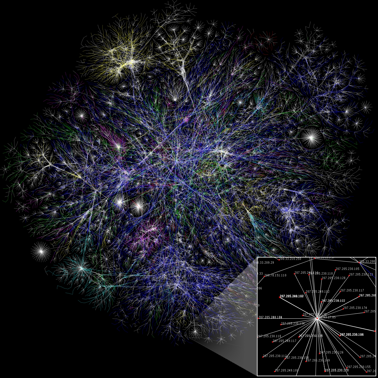
A transport network, or transportation network, is a network or graph in geographic space, describing an infrastructure that permits and constrains movement or flow. Examples include but are not limited to road networks, railways, air routes, pipelines, aqueducts, and power lines. The digital representation of these networks, and the methods for their analysis, is a core part of spatial analysis, geographic information systems, public utilities, and transport engineering. Network analysis is an application of the theories and algorithms of graph theory and is a form of proximity analysis.
The applicability of graph theory to geographic phenomena was recognized at an early date. Many of the early problems and theories undertaken by graph theorists were inspired by geographic situations, such as the Seven Bridges of Königsberg problem, which was one of the original foundations of graph theory when it was solved by Leonhard Euler in 1736.
In the 1970s, the connection was reestablished by the early developers of geographic information systems, who employed it in the topological data structures of polygons (which is not of relevance here), and the analysis of transport networks. Early works, such as Tinkler (1977), focused mainly on simple schematic networks, likely due to the lack of significant volumes of linear data and the computational complexity of many of the algorithms. The full implementation of network analysis algorithms in GIS software did not appear until the 1990s, but rather advanced tools are generally available today.
Network analysis requires detailed data representing the elements of the network and its properties. The core of a network dataset is a vector layer of polylines representing the paths of travel, either precise geographic routes or schematic diagrams, known as edges. In addition, information is needed on the network topology, representing the connections between the lines, thus enabling the transport from one line to another to be modeled. Typically, these connection points, or nodes, are included as an additional dataset.
Both the edges and nodes are attributed with properties related to the movement or flow:
A wide range of methods, algorithms, and techniques have been developed for solving problems and tasks relating to network flow. Some of these are common to all types of transport networks, while others are specific to particular application domains. Many of these algorithms are implemented in commercial and open-source GIS software, such as GRASS GIS and the Network Analyst extension to Esri ArcGIS.
One of the simplest and most common tasks in a network is to find the optimal route connecting two points along the network, with optimal defined as minimizing some form of cost, such as distance, energy expenditure, or time. A common example is finding directions in a street network, a feature of almost any web street mapping application such as Google Maps. The most popular method of solving this task, implemented in most GIS and mapping software, is Dijkstra's algorithm.
In addition to the basic point-to-point routing, composite routing problems are also common. The Traveling salesman problem asks for the optimal (least distance/cost) ordering and route to reach a number of destinations; it is an NP-hard problem, but somewhat easier to solve in network space than unconstrained space due to the smaller solution set. The Vehicle routing problem is a generalization of this, allowing for multiple simultaneous routes to reach the destinations. The Route inspection or "Chinese Postman" problem asks for the optimal (least distance/cost) path that traverses every edge; a common application is the routing of garbage trucks. This turns out to be a much simpler problem to solve, with polynomial time algorithms.
Hub AI
Transport network analysis AI simulator
(@Transport network analysis_simulator)
Transport network analysis
A transport network, or transportation network, is a network or graph in geographic space, describing an infrastructure that permits and constrains movement or flow. Examples include but are not limited to road networks, railways, air routes, pipelines, aqueducts, and power lines. The digital representation of these networks, and the methods for their analysis, is a core part of spatial analysis, geographic information systems, public utilities, and transport engineering. Network analysis is an application of the theories and algorithms of graph theory and is a form of proximity analysis.
The applicability of graph theory to geographic phenomena was recognized at an early date. Many of the early problems and theories undertaken by graph theorists were inspired by geographic situations, such as the Seven Bridges of Königsberg problem, which was one of the original foundations of graph theory when it was solved by Leonhard Euler in 1736.
In the 1970s, the connection was reestablished by the early developers of geographic information systems, who employed it in the topological data structures of polygons (which is not of relevance here), and the analysis of transport networks. Early works, such as Tinkler (1977), focused mainly on simple schematic networks, likely due to the lack of significant volumes of linear data and the computational complexity of many of the algorithms. The full implementation of network analysis algorithms in GIS software did not appear until the 1990s, but rather advanced tools are generally available today.
Network analysis requires detailed data representing the elements of the network and its properties. The core of a network dataset is a vector layer of polylines representing the paths of travel, either precise geographic routes or schematic diagrams, known as edges. In addition, information is needed on the network topology, representing the connections between the lines, thus enabling the transport from one line to another to be modeled. Typically, these connection points, or nodes, are included as an additional dataset.
Both the edges and nodes are attributed with properties related to the movement or flow:
A wide range of methods, algorithms, and techniques have been developed for solving problems and tasks relating to network flow. Some of these are common to all types of transport networks, while others are specific to particular application domains. Many of these algorithms are implemented in commercial and open-source GIS software, such as GRASS GIS and the Network Analyst extension to Esri ArcGIS.
One of the simplest and most common tasks in a network is to find the optimal route connecting two points along the network, with optimal defined as minimizing some form of cost, such as distance, energy expenditure, or time. A common example is finding directions in a street network, a feature of almost any web street mapping application such as Google Maps. The most popular method of solving this task, implemented in most GIS and mapping software, is Dijkstra's algorithm.
In addition to the basic point-to-point routing, composite routing problems are also common. The Traveling salesman problem asks for the optimal (least distance/cost) ordering and route to reach a number of destinations; it is an NP-hard problem, but somewhat easier to solve in network space than unconstrained space due to the smaller solution set. The Vehicle routing problem is a generalization of this, allowing for multiple simultaneous routes to reach the destinations. The Route inspection or "Chinese Postman" problem asks for the optimal (least distance/cost) path that traverses every edge; a common application is the routing of garbage trucks. This turns out to be a much simpler problem to solve, with polynomial time algorithms.