Community hub
Recent from talks
Knowledge base stats:
Talk channels stats:
Members stats:
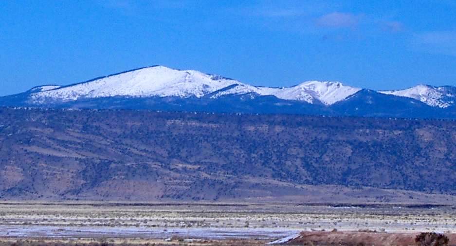
Mount Taylor (New Mexico)
Mount Taylor (Navajo: Tsoodził, Navajo pronunciation: [tsʰòːtsɪ̀ɬ] means "The Great Mountain") is a dormant stratovolcano in northwest New Mexico, northeast of the town of Grants. It is the high point of the San Mateo Mountains and the highest point in the Cibola National Forest.
It was renamed in 1849 for then president Zachary Taylor. Previously, it was called Cebolleta (tender onion) by the Spaniards; the name persists as one name for the northern portion of the San Mateo Mountains, a large mesa. The Navajo, for whom the mountain is sacred, still call it Turquoise Mountain (Tsoodził).
Mount Taylor is largely forested with some meadows, rising above the desert below. The mountain is heavily eroded to the east. Its slopes were an important source of lumber for neighboring pueblos.
Mount Taylor volcano is a prominent volcano that is part of a larger volcanic field that trends to the northeast. The Mount Taylor volcanic field includes Mesa Chivato to the northeast and Grants Ridge to the southwest. The Mount Taylor volcanic field is composed primarily of silica-poor (mafic) lava (with 80% by volume), most of which is trachybasalt. Basalt and basanite are present in much smaller amounts. The field straddles the extensional transition zone between the Colorado Plateau and the Rio Grande rift. The largest volcanic plug in the volcanic field is Cabezon Peak, which rises nearly 2,000 feet above the surrounding plain.
Mount Taylor is sacred to the pueblos of Acoma, Laguna and Zuni, and the Hopi and Navajo people. Mount Taylor is Tsoodził, the blue bead mountain, sometimes translated as Turquoise Mountain, one of the four sacred mountains marking the cardinal directions and the boundaries of the Dinetah, the traditional Navajo homeland. Mount Taylor marks the southern boundary, and is associated with the direction south and the color blue; it is gendered female. In Navajo mythology, First Man created the sacred mountains from soil from the Fourth World, together with sacred matter, as replicas of mountains from that world. He fastened Mount Taylor to the earth with a stone knife. The supernatural beings Black God, Turquoise Boy, and Turquoise Girl are said to reside on the mountain. According to Robert Julyan's The Place Names of New Mexico, the Navajos identify Cabezon Peak "as the head of a giant killed by the Twin War Gods" with the lava flow to the south of Grants believed to be the congealed blood of the giant.
The mountain is heavily eroded to the east, exposing a large amphitheater that is approximately 5 square miles. Estimates vary about how high the mountain was at its highest. An extreme estimate places it near 4,270 meters (14,000 ft), but it is more likely the volcano was never higher than 3,800 meters (12,000 ft). The mountain is surrounded by a great volume of volcanic debris, but the debris field and the natural amphitheater in the central part of the mountain are attributed to erosion rather than a late stage explosion similar to Valles Caldera, Mount St. Helens or the San Francisco Peaks. Downcutting has been great enough to expose Cretaceous sedimentary rocks at the core of the cone.
The Mount Taylor Volcanic Field is a series of Upper Cenozoic volcanic beds that overlies Cretaceous sedimentary rocks in central New Mexico. This volcanic field is part of the Jemez Lineament, which is associated with relatively young volcanism (< 5 Mya) due to an ancient suture in the Proterozoic basement rock. The general stratigraphy of the volcanic field starts with a more intermediate (rhyolitic) lava composition and transitions to a more mafic (basaltic) composition as more eruptions occurred. The transition of this magma from alkalic to basaltic eruptions is thought to have resulted form multiple, short-lived magma chambers within Mount Taylor, instead of one long-lived chamber that experienced fractional crystallization.
Mount Taylor was active during the Pliocene to Pleistocene, and is surrounded by a field of smaller inactive volcanoes. Potassium-argon (K-Ar) dating showed that a large majority of the volcanic activity from Mount Taylor occurred between 4.3 and 1.5 million years ago, with the peak of the volcanism occurring between 3.0 mya and 2.5 mya. Mount Taylor volcano was the leading source of volcanism in this area for this time period, aside from some local basalt eruptions.
Hub AI
Mount Taylor (New Mexico) AI simulator
(@Mount Taylor (New Mexico)_simulator)
Mount Taylor (New Mexico)
Mount Taylor (Navajo: Tsoodził, Navajo pronunciation: [tsʰòːtsɪ̀ɬ] means "The Great Mountain") is a dormant stratovolcano in northwest New Mexico, northeast of the town of Grants. It is the high point of the San Mateo Mountains and the highest point in the Cibola National Forest.
It was renamed in 1849 for then president Zachary Taylor. Previously, it was called Cebolleta (tender onion) by the Spaniards; the name persists as one name for the northern portion of the San Mateo Mountains, a large mesa. The Navajo, for whom the mountain is sacred, still call it Turquoise Mountain (Tsoodził).
Mount Taylor is largely forested with some meadows, rising above the desert below. The mountain is heavily eroded to the east. Its slopes were an important source of lumber for neighboring pueblos.
Mount Taylor volcano is a prominent volcano that is part of a larger volcanic field that trends to the northeast. The Mount Taylor volcanic field includes Mesa Chivato to the northeast and Grants Ridge to the southwest. The Mount Taylor volcanic field is composed primarily of silica-poor (mafic) lava (with 80% by volume), most of which is trachybasalt. Basalt and basanite are present in much smaller amounts. The field straddles the extensional transition zone between the Colorado Plateau and the Rio Grande rift. The largest volcanic plug in the volcanic field is Cabezon Peak, which rises nearly 2,000 feet above the surrounding plain.
Mount Taylor is sacred to the pueblos of Acoma, Laguna and Zuni, and the Hopi and Navajo people. Mount Taylor is Tsoodził, the blue bead mountain, sometimes translated as Turquoise Mountain, one of the four sacred mountains marking the cardinal directions and the boundaries of the Dinetah, the traditional Navajo homeland. Mount Taylor marks the southern boundary, and is associated with the direction south and the color blue; it is gendered female. In Navajo mythology, First Man created the sacred mountains from soil from the Fourth World, together with sacred matter, as replicas of mountains from that world. He fastened Mount Taylor to the earth with a stone knife. The supernatural beings Black God, Turquoise Boy, and Turquoise Girl are said to reside on the mountain. According to Robert Julyan's The Place Names of New Mexico, the Navajos identify Cabezon Peak "as the head of a giant killed by the Twin War Gods" with the lava flow to the south of Grants believed to be the congealed blood of the giant.
The mountain is heavily eroded to the east, exposing a large amphitheater that is approximately 5 square miles. Estimates vary about how high the mountain was at its highest. An extreme estimate places it near 4,270 meters (14,000 ft), but it is more likely the volcano was never higher than 3,800 meters (12,000 ft). The mountain is surrounded by a great volume of volcanic debris, but the debris field and the natural amphitheater in the central part of the mountain are attributed to erosion rather than a late stage explosion similar to Valles Caldera, Mount St. Helens or the San Francisco Peaks. Downcutting has been great enough to expose Cretaceous sedimentary rocks at the core of the cone.
The Mount Taylor Volcanic Field is a series of Upper Cenozoic volcanic beds that overlies Cretaceous sedimentary rocks in central New Mexico. This volcanic field is part of the Jemez Lineament, which is associated with relatively young volcanism (< 5 Mya) due to an ancient suture in the Proterozoic basement rock. The general stratigraphy of the volcanic field starts with a more intermediate (rhyolitic) lava composition and transitions to a more mafic (basaltic) composition as more eruptions occurred. The transition of this magma from alkalic to basaltic eruptions is thought to have resulted form multiple, short-lived magma chambers within Mount Taylor, instead of one long-lived chamber that experienced fractional crystallization.
Mount Taylor was active during the Pliocene to Pleistocene, and is surrounded by a field of smaller inactive volcanoes. Potassium-argon (K-Ar) dating showed that a large majority of the volcanic activity from Mount Taylor occurred between 4.3 and 1.5 million years ago, with the peak of the volcanism occurring between 3.0 mya and 2.5 mya. Mount Taylor volcano was the leading source of volcanism in this area for this time period, aside from some local basalt eruptions.