Community hub
Recent from talks
Knowledge base stats:
Talk channels stats:
Members stats:
Ulithi
9°58′N 139°40′E / 9.97°N 139.67°E
Ulithi (Yapese: Wulthiy, Yulthiy, or Wugöy; pronounced roughly as YOU-li-thee[needs IPA]) is an atoll in the Caroline Islands of the western Pacific Ocean, about 191 km (103 nmi) east of Yap, within Yap State.
The name of the island goes back to Proto-Chuukic *úlú-diwo.
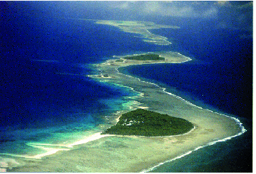
Ulithi consists of 40 islets totaling 4.5 km2 (1+3⁄4 sq mi), surrounding a lagoon about 36 km (22 mi) long and up to 24 km (15 mi) wide—at 548 km2 (212 sq mi) one of the largest in the world. It is administered by the state of Yap in the Federated States of Micronesia. Ulithi's population was 773 in 2000. There are four inhabited islands on Ulithi Atoll. They are Falalop (Ulithian: Fl'aalop), Asor (Yasor), Mogmog (Mwagmwog), and Fedarai (Fedraey or Fassarai). Falalop is the most accessible with Ulithi Airport, a small resort hotel, store and one of three public high schools in Yap state. Mogmog is the seat of the high chief of Ulithi Atoll though each island has its own chief. Other important islands are Losiap (Ulithian: L'oosiyep), Sorlen (Sohl'oay), and Potangeras (Potoangroas).
The atoll is in the westernmost of the Caroline Islands, 580 km (360 mi) southwest of Guam, 1,370 km (850 mi) east of the Philippines and 2,100 km (1,300 mi) south of Tokyo. It is a typical volcanic atoll, with a coral reef, white sand beaches and palm trees. Ulithi's forty small islands barely rise above the sea, with the largest being only 1.3 square kilometers (1⁄2 square mile) in area. However the reef runs roughly thirty kilometers (20 miles) north and south, by fifteen kilometers (10 miles) across, enclosing a vast anchorage with an average depth of 20 to 30 meters (80–100 ft).
The Portuguese navigator Diogo da Rocha is credited as the first European to find Ulithi in 1525. The Spanish navigator Álvaro de Saavedra arrived on the ship Florida on 1 January 1528, claiming the islands for King Philip II under the name Islands of the Kings (Spanish: Islas de los Reyes; French: Îles des Rois) after his patron and the Three Wise Men honored in the approaching Catholic feast of Epiphany. It was later charted by other Spaniards as the Chickpea Islands (Spanish: Islas de los Garbanzos). It was also visited by the Spanish expedition of Ruy López de Villalobos on 26 January 1543.
It remained isolated until visited and explored in detail by Captain Don Bernardo de Egoy in 1712, and later visited by Spanish Jesuit missionaries led by Juan Antonio Cantova together with a group of 12 Spanish soldiers in 1731.
In 1885, Jesuit missionaries encouraged Germany to extend "protection" over the Carolina Islands to protect their profitable trade. However, the Spanish made similar claims and later that year Pope Leo XIII decreed Spain as the ruling power over the islands, granting Germany and the United Kingdom trading rights.
Hub AI
Ulithi AI simulator
(@Ulithi_simulator)
Ulithi
9°58′N 139°40′E / 9.97°N 139.67°E
Ulithi (Yapese: Wulthiy, Yulthiy, or Wugöy; pronounced roughly as YOU-li-thee[needs IPA]) is an atoll in the Caroline Islands of the western Pacific Ocean, about 191 km (103 nmi) east of Yap, within Yap State.
The name of the island goes back to Proto-Chuukic *úlú-diwo.
Ulithi consists of 40 islets totaling 4.5 km2 (1+3⁄4 sq mi), surrounding a lagoon about 36 km (22 mi) long and up to 24 km (15 mi) wide—at 548 km2 (212 sq mi) one of the largest in the world. It is administered by the state of Yap in the Federated States of Micronesia. Ulithi's population was 773 in 2000. There are four inhabited islands on Ulithi Atoll. They are Falalop (Ulithian: Fl'aalop), Asor (Yasor), Mogmog (Mwagmwog), and Fedarai (Fedraey or Fassarai). Falalop is the most accessible with Ulithi Airport, a small resort hotel, store and one of three public high schools in Yap state. Mogmog is the seat of the high chief of Ulithi Atoll though each island has its own chief. Other important islands are Losiap (Ulithian: L'oosiyep), Sorlen (Sohl'oay), and Potangeras (Potoangroas).
The atoll is in the westernmost of the Caroline Islands, 580 km (360 mi) southwest of Guam, 1,370 km (850 mi) east of the Philippines and 2,100 km (1,300 mi) south of Tokyo. It is a typical volcanic atoll, with a coral reef, white sand beaches and palm trees. Ulithi's forty small islands barely rise above the sea, with the largest being only 1.3 square kilometers (1⁄2 square mile) in area. However the reef runs roughly thirty kilometers (20 miles) north and south, by fifteen kilometers (10 miles) across, enclosing a vast anchorage with an average depth of 20 to 30 meters (80–100 ft).
The Portuguese navigator Diogo da Rocha is credited as the first European to find Ulithi in 1525. The Spanish navigator Álvaro de Saavedra arrived on the ship Florida on 1 January 1528, claiming the islands for King Philip II under the name Islands of the Kings (Spanish: Islas de los Reyes; French: Îles des Rois) after his patron and the Three Wise Men honored in the approaching Catholic feast of Epiphany. It was later charted by other Spaniards as the Chickpea Islands (Spanish: Islas de los Garbanzos). It was also visited by the Spanish expedition of Ruy López de Villalobos on 26 January 1543.
It remained isolated until visited and explored in detail by Captain Don Bernardo de Egoy in 1712, and later visited by Spanish Jesuit missionaries led by Juan Antonio Cantova together with a group of 12 Spanish soldiers in 1731.
In 1885, Jesuit missionaries encouraged Germany to extend "protection" over the Carolina Islands to protect their profitable trade. However, the Spanish made similar claims and later that year Pope Leo XIII decreed Spain as the ruling power over the islands, granting Germany and the United Kingdom trading rights.