



Community hub
Recent from talks
Knowledge base stats:
Talk channels stats:
Members stats:
Villavicencio
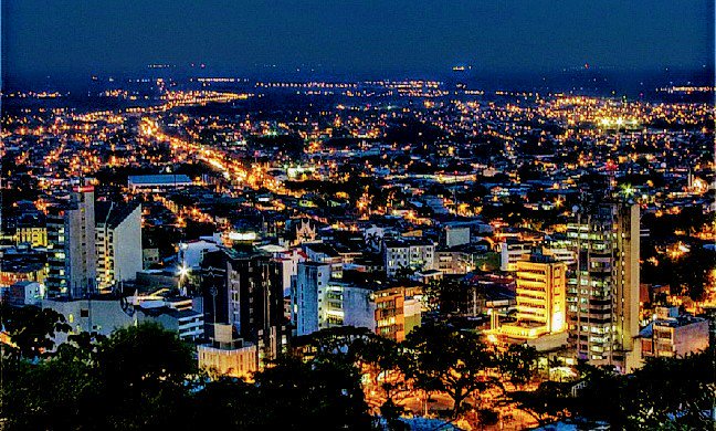
Villavicencio (Latin American Spanish pronunciation: [biʝaβiˈsensjo]) is a city and municipality in Colombia. The capital of Meta Department, it was founded on April 6, 1840. The municipality had a population of 531,275 in 2018. The city is located at 4°08'N, 73°40'W, 75 km (about 45 mi) southeast of the Colombian capital city of Bogotá (DC) by the Guatiquía River. It is the most important commercial center in the Llanos Orientales (eastern plains) of Colombia.
Villavicencio has a hot and very wet climate, with average daily temperatures ranging from 21 to 30 °C (70 to 86 °F) and an annual rainfall of around 4,500 millimetres or 180 inches. It is affectionately called "Villavo" la bella. Villavicencio lies on the great Colombian-Venezuelan plain called the Llanos, situated to the east of the Andes mountains. Villavicencio is also called "La Puerta al Llano", or "The Gateway to the Plains", due to its location on the historical path from the Colombian interior to the vast savannas that lie between the Andes range and the Amazon rainforest.
Villavicencio's proximity to huge mountains and great plains make the city an example of Colombia's geodiversity. Because it is located in the foothills of the Andes, the morning and evening breezes cool the city, which is very hot for most of the day.
The German Conquistador Nikolaus Federmann reached the altiplano of Bogotá in 1536 by approaching it from the plains of Venezuela, a large unsettled area that is formed by the Orinoco basin. However, the vast area of these plains remained unexplored and uncolonized for the next 300 years. Colombia was settled along the mountainous folds of the Magdalena and Cauca valleys, and its commerce with the outside world was oriented towards the Caribbean Sea, thus, because of its mountainous barriers, the extreme heat, and inhospitable climate, the Llanos remained forgotten and unsettled for many decades.
The Llaneros, the inhabitants of the plains, are fierce horsemen who first fought for the Spanish royalists and then for the Venezuelan and Colombian rebels during the War of Independence.[citation needed] During independence, they crossed the Cordillera Oriental with Simón Bolívar, and surprised the royalist army on the plains of Boyaca on the 6th of August, 1819, which cleared the way for the taking of an abandoned Santa Fe de Bogotá the next week.
In the 1840s, some farmers from Caqueza, a town on the eastern folds of Bogotá, started the modest settlement of Gramalote, which would officially become the parish of Villavicencio in 1855. The parish was named for Antonio Villavicencio, a patriot in the Colombian war of independence. Vaccines, a mule road, and the availability of vast areas of free land, drove new colonizers to continue the settlement of Villavicencio. As the roads improved the access to the Llanos, the farmers could send their produce and cattle to the markets of Bogotá.
In 1948, large landowners expelled many farmers out of their lands across the country, explained in part by the momentum of the assassination of Jorge Eliecer Gaitan, a popular Liberal politician.[citation needed] The Llaneros resisted by driving the army out of population centers. The guerrillas never took Villavicencio, but they brought the fighting to the military base of Apiay. As the fighting between the government and the Llanero guerrillas was out of control, a military coup in June 1953, took Gustavo Rojas Pinilla to power who immediately negotiated a cease fire and amnesty for the insurgents.
Villavicencio has grown from a small settlement of no more than 20 people in the 1850s to a settlement of over 500,000 inhabitants in 2018. A new road of bridges and tunnels has shortened the driving time to Bogotá from two or three hours, depending on the season of the year, to one and half hours to move the oil, cattle, and agricultural products faster.
Hub AI
Villavicencio AI simulator
(@Villavicencio_simulator)
Villavicencio
Villavicencio (Latin American Spanish pronunciation: [biʝaβiˈsensjo]) is a city and municipality in Colombia. The capital of Meta Department, it was founded on April 6, 1840. The municipality had a population of 531,275 in 2018. The city is located at 4°08'N, 73°40'W, 75 km (about 45 mi) southeast of the Colombian capital city of Bogotá (DC) by the Guatiquía River. It is the most important commercial center in the Llanos Orientales (eastern plains) of Colombia.
Villavicencio has a hot and very wet climate, with average daily temperatures ranging from 21 to 30 °C (70 to 86 °F) and an annual rainfall of around 4,500 millimetres or 180 inches. It is affectionately called "Villavo" la bella. Villavicencio lies on the great Colombian-Venezuelan plain called the Llanos, situated to the east of the Andes mountains. Villavicencio is also called "La Puerta al Llano", or "The Gateway to the Plains", due to its location on the historical path from the Colombian interior to the vast savannas that lie between the Andes range and the Amazon rainforest.
Villavicencio's proximity to huge mountains and great plains make the city an example of Colombia's geodiversity. Because it is located in the foothills of the Andes, the morning and evening breezes cool the city, which is very hot for most of the day.
The German Conquistador Nikolaus Federmann reached the altiplano of Bogotá in 1536 by approaching it from the plains of Venezuela, a large unsettled area that is formed by the Orinoco basin. However, the vast area of these plains remained unexplored and uncolonized for the next 300 years. Colombia was settled along the mountainous folds of the Magdalena and Cauca valleys, and its commerce with the outside world was oriented towards the Caribbean Sea, thus, because of its mountainous barriers, the extreme heat, and inhospitable climate, the Llanos remained forgotten and unsettled for many decades.
The Llaneros, the inhabitants of the plains, are fierce horsemen who first fought for the Spanish royalists and then for the Venezuelan and Colombian rebels during the War of Independence.[citation needed] During independence, they crossed the Cordillera Oriental with Simón Bolívar, and surprised the royalist army on the plains of Boyaca on the 6th of August, 1819, which cleared the way for the taking of an abandoned Santa Fe de Bogotá the next week.
In the 1840s, some farmers from Caqueza, a town on the eastern folds of Bogotá, started the modest settlement of Gramalote, which would officially become the parish of Villavicencio in 1855. The parish was named for Antonio Villavicencio, a patriot in the Colombian war of independence. Vaccines, a mule road, and the availability of vast areas of free land, drove new colonizers to continue the settlement of Villavicencio. As the roads improved the access to the Llanos, the farmers could send their produce and cattle to the markets of Bogotá.
In 1948, large landowners expelled many farmers out of their lands across the country, explained in part by the momentum of the assassination of Jorge Eliecer Gaitan, a popular Liberal politician.[citation needed] The Llaneros resisted by driving the army out of population centers. The guerrillas never took Villavicencio, but they brought the fighting to the military base of Apiay. As the fighting between the government and the Llanero guerrillas was out of control, a military coup in June 1953, took Gustavo Rojas Pinilla to power who immediately negotiated a cease fire and amnesty for the insurgents.
Villavicencio has grown from a small settlement of no more than 20 people in the 1850s to a settlement of over 500,000 inhabitants in 2018. A new road of bridges and tunnels has shortened the driving time to Bogotá from two or three hours, depending on the season of the year, to one and half hours to move the oil, cattle, and agricultural products faster.