
Recent from talks
Weather satellite
Knowledge base stats:
Talk channels stats:
Members stats:
Weather satellite
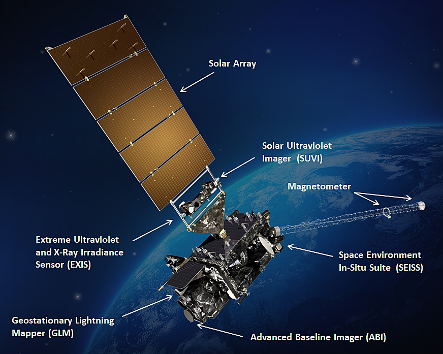
A weather satellite or meteorological satellite is a type of Earth observation satellite that is primarily used to monitor the weather and climate of the Earth. Satellites are mainly of two types: polar orbiting (covering the entire Earth asynchronously) or geostationary (hovering over the same spot on the equator).
While primarily used to detect the development and movement of storm systems and other cloud patterns, meteorological satellites can also detect other phenomena such as city lights, fires, effects of pollution, auroras, sand and dust storms, tornadoes, snow cover, ice mapping, boundaries of ocean currents, and energy flows. Other types of environmental information are collected using weather satellites. Weather satellite images helped in monitoring the volcanic ash cloud from Mount St. Helens and activity from other volcanoes such as Mount Etna. Smoke from fires in the western United States such as Colorado and Utah have also been monitored.
El Niño and its effects on weather are monitored daily from satellite images. The Antarctic ozone hole is mapped from weather satellite data. Collectively, weather satellites flown by the U.S., China, Europe, India, Russia, and Japan provide nearly continuous observations for a global weather watch.
As early as 1946, the idea of cameras in orbit to observe the weather was being developed. This was due to sparse data observation coverage and the expense of using cloud cameras on rockets. By 1958, the early prototypes for TIROS and Vanguard (developed by the Army Signal Corps) were created. The first weather satellite, Vanguard 2, was launched on February 17, 1959. It was designed to measure cloud cover and resistance, but a poor axis of rotation and its elliptical orbit kept it from collecting a notable amount of useful data. The Explorer 6 and Explorer 7 satellites also contained weather-related experiments.
The first weather satellite to be considered a success was TIROS-1, launched by NASA on April 1, 1960. TIROS operated for 78 days and proved to be much more successful than Vanguard 2. Other early weather satellite programs include the 1962 Defense Satellite Applications Program (DSAP) and the 1964 Soviet Meteor series.
TIROS paved the way for the Nimbus program, whose technology and findings are the heritage of most of the Earth-observing satellites NASA and NOAA have launched since then. Beginning with the Nimbus 3 satellite in 1969, temperature information through the tropospheric column began to be retrieved by satellites from the eastern Atlantic and most of the Pacific Ocean, which led to significant improvements to weather forecasts.
The ESSA and NOAA polar orbiting satellites followed suit from the late 1960s onward. Geostationary satellites followed, beginning with the ATS and SMS series in the late 1960s and early 1970s, then continuing with the GOES series from the 1970s onward. Polar orbiting satellites such as QuikScat and TRMM began to relay wind information near the ocean's surface starting in the late 1970s, with microwave imagery which resembled radar displays, which significantly improved the diagnoses of tropical cyclone strength, intensification, and location during the 2000s and 2010s.
In Europe, the first Meteosat geostationary operational meteorological satellite, Meteosat-1, was launched in 1977 on a Delta launch vehicle. The satellite was a spin-stabilised cylindrical design, 2.1 m in diameter and 3.2 m tall, rotating at approx. 100 rpm and carrying the Meteosat Visible and Infrared Imager (MVIRI) instrument. Successive Meteosat first generation satellites were launched, on European Ariane-4 launchers from Kourou in French Guyana, up to and including Meteosat-7 which acquired data from 1997 until 2017, operated initially by the European Space Agency and later by the European Organisation for the Exploitation of Meteorological Satellites (EUMETSAT).
Hub AI
Weather satellite AI simulator
(@Weather satellite_simulator)
Weather satellite
A weather satellite or meteorological satellite is a type of Earth observation satellite that is primarily used to monitor the weather and climate of the Earth. Satellites are mainly of two types: polar orbiting (covering the entire Earth asynchronously) or geostationary (hovering over the same spot on the equator).
While primarily used to detect the development and movement of storm systems and other cloud patterns, meteorological satellites can also detect other phenomena such as city lights, fires, effects of pollution, auroras, sand and dust storms, tornadoes, snow cover, ice mapping, boundaries of ocean currents, and energy flows. Other types of environmental information are collected using weather satellites. Weather satellite images helped in monitoring the volcanic ash cloud from Mount St. Helens and activity from other volcanoes such as Mount Etna. Smoke from fires in the western United States such as Colorado and Utah have also been monitored.
El Niño and its effects on weather are monitored daily from satellite images. The Antarctic ozone hole is mapped from weather satellite data. Collectively, weather satellites flown by the U.S., China, Europe, India, Russia, and Japan provide nearly continuous observations for a global weather watch.
As early as 1946, the idea of cameras in orbit to observe the weather was being developed. This was due to sparse data observation coverage and the expense of using cloud cameras on rockets. By 1958, the early prototypes for TIROS and Vanguard (developed by the Army Signal Corps) were created. The first weather satellite, Vanguard 2, was launched on February 17, 1959. It was designed to measure cloud cover and resistance, but a poor axis of rotation and its elliptical orbit kept it from collecting a notable amount of useful data. The Explorer 6 and Explorer 7 satellites also contained weather-related experiments.
The first weather satellite to be considered a success was TIROS-1, launched by NASA on April 1, 1960. TIROS operated for 78 days and proved to be much more successful than Vanguard 2. Other early weather satellite programs include the 1962 Defense Satellite Applications Program (DSAP) and the 1964 Soviet Meteor series.
TIROS paved the way for the Nimbus program, whose technology and findings are the heritage of most of the Earth-observing satellites NASA and NOAA have launched since then. Beginning with the Nimbus 3 satellite in 1969, temperature information through the tropospheric column began to be retrieved by satellites from the eastern Atlantic and most of the Pacific Ocean, which led to significant improvements to weather forecasts.
The ESSA and NOAA polar orbiting satellites followed suit from the late 1960s onward. Geostationary satellites followed, beginning with the ATS and SMS series in the late 1960s and early 1970s, then continuing with the GOES series from the 1970s onward. Polar orbiting satellites such as QuikScat and TRMM began to relay wind information near the ocean's surface starting in the late 1970s, with microwave imagery which resembled radar displays, which significantly improved the diagnoses of tropical cyclone strength, intensification, and location during the 2000s and 2010s.
In Europe, the first Meteosat geostationary operational meteorological satellite, Meteosat-1, was launched in 1977 on a Delta launch vehicle. The satellite was a spin-stabilised cylindrical design, 2.1 m in diameter and 3.2 m tall, rotating at approx. 100 rpm and carrying the Meteosat Visible and Infrared Imager (MVIRI) instrument. Successive Meteosat first generation satellites were launched, on European Ariane-4 launchers from Kourou in French Guyana, up to and including Meteosat-7 which acquired data from 1997 until 2017, operated initially by the European Space Agency and later by the European Organisation for the Exploitation of Meteorological Satellites (EUMETSAT).
Recent media