
Community hub
Recent from talks
Contribute something
Nothing was collected or created yet.
BCN Main Line
View on Wikipedia
Key Information

BCN Main Lines | |||||||||||||||||||||||||||||||||||||||||||||||||||||||||||||||||||||||||||||||||||||||||||||||||||||||||||||||||||||||||||||||||||||||||||||||||||||||||||||||||||||||||||||||||||||||||||||||||||||||||||||||||||||||||||||||||||||||||||||||||||||||||||||||||||||||||||||||||||||||||||||||||||||||||||||||||||||||||||||||||||||||||||||||||||||||||||||||||||||||||||||||||||||||||||||||||||||||||||||||||||||||||||||||||||||||||||||||||||||||||||||||||||||||||||||||||||||||||||||||||||||||||||||||||||||||||||||||
|---|---|---|---|---|---|---|---|---|---|---|---|---|---|---|---|---|---|---|---|---|---|---|---|---|---|---|---|---|---|---|---|---|---|---|---|---|---|---|---|---|---|---|---|---|---|---|---|---|---|---|---|---|---|---|---|---|---|---|---|---|---|---|---|---|---|---|---|---|---|---|---|---|---|---|---|---|---|---|---|---|---|---|---|---|---|---|---|---|---|---|---|---|---|---|---|---|---|---|---|---|---|---|---|---|---|---|---|---|---|---|---|---|---|---|---|---|---|---|---|---|---|---|---|---|---|---|---|---|---|---|---|---|---|---|---|---|---|---|---|---|---|---|---|---|---|---|---|---|---|---|---|---|---|---|---|---|---|---|---|---|---|---|---|---|---|---|---|---|---|---|---|---|---|---|---|---|---|---|---|---|---|---|---|---|---|---|---|---|---|---|---|---|---|---|---|---|---|---|---|---|---|---|---|---|---|---|---|---|---|---|---|---|---|---|---|---|---|---|---|---|---|---|---|---|---|---|---|---|---|---|---|---|---|---|---|---|---|---|---|---|---|---|---|---|---|---|---|---|---|---|---|---|---|---|---|---|---|---|---|---|---|---|---|---|---|---|---|---|---|---|---|---|---|---|---|---|---|---|---|---|---|---|---|---|---|---|---|---|---|---|---|---|---|---|---|---|---|---|---|---|---|---|---|---|---|---|---|---|---|---|---|---|---|---|---|---|---|---|---|---|---|---|---|---|---|---|---|---|---|---|---|---|---|---|---|---|---|---|---|---|---|---|---|---|---|---|---|---|---|---|---|---|---|---|---|---|---|---|---|---|---|---|---|---|---|---|---|---|---|---|---|---|---|---|---|---|---|---|---|---|---|---|---|---|---|---|---|---|---|---|---|---|---|---|---|---|---|---|---|---|---|---|---|---|---|---|---|---|---|---|---|---|---|---|---|---|---|---|---|---|---|---|---|---|---|---|---|---|---|---|---|---|---|---|---|---|---|---|---|---|---|---|---|---|---|---|---|---|---|---|---|---|---|---|---|---|---|---|---|---|---|---|---|---|---|---|---|---|---|---|---|---|---|---|---|---|---|---|---|---|---|---|---|---|---|---|---|---|---|---|---|---|---|---|---|---|---|---|---|---|---|---|---|---|---|---|---|---|---|---|---|
Wolverhampton to Birmingham
| |||||||||||||||||||||||||||||||||||||||||||||||||||||||||||||||||||||||||||||||||||||||||||||||||||||||||||||||||||||||||||||||||||||||||||||||||||||||||||||||||||||||||||||||||||||||||||||||||||||||||||||||||||||||||||||||||||||||||||||||||||||||||||||||||||||||||||||||||||||||||||||||||||||||||||||||||||||||||||||||||||||||||||||||||||||||||||||||||||||||||||||||||||||||||||||||||||||||||||||||||||||||||||||||||||||||||||||||||||||||||||||||||||||||||||||||||||||||||||||||||||||||||||||||||||||||||||||||
| |||||||||||||||||||||||||||||||||||||||||||||||||||||||||||||||||||||||||||||||||||||||||||||||||||||||||||||||||||||||||||||||||||||||||||||||||||||||||||||||||||||||||||||||||||||||||||||||||||||||||||||||||||||||||||||||||||||||||||||||||||||||||||||||||||||||||||||||||||||||||||||||||||||||||||||||||||||||||||||||||||||||||||||||||||||||||||||||||||||||||||||||||||||||||||||||||||||||||||||||||||||||||||||||||||||||||||||||||||||||||||||||||||||||||||||||||||||||||||||||||||||||||||||||||||||||||||||||
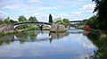
The BCN Main Line, or Birmingham Canal Navigations Main Line is the evolving route of the Birmingham Canal between Birmingham and Wolverhampton in England.
The name Main Line was used to distinguish the main Birmingham to Wolverhampton route from the many other canals and branches built or acquired by the Birmingham Canal Navigations company.
BCN Old Main Line
[edit]
On 24 January 1767, a number of prominent Birmingham businessmen, including Matthew Boulton and others from the Lunar Society,[1] held a public meeting in the White Swan, High Street, Birmingham[2] to consider the possibility of building a canal from Birmingham to the Staffordshire and Worcestershire Canal near Wolverhampton, taking in the coalfields of the Black Country. They commissioned the canal engineer James Brindley to propose a route. Brindley came back with a largely level but meandering route via Smethwick, Oldbury, Tipton, Bilston and Wolverhampton to Aldersley.[1][3]
On 24 February 1768, an Act of Parliament was passed to allow the building of the canal, with branches at Ocker Hill and Wednesbury[1] where there were coal mines. The Staffordshire and Worcestershire company was given the right to make the connection to their canal if the Birmingham company failed to do so within six months of opening.[3] On 2 March[3] Brindley was appointed engineer.[1] The first phase of building was to Wednesbury whereupon the price of coal sold to domestic households in Birmingham halved overnight.[2] Vested interests of the sponsors caused the creation of two terminal wharves in Birmingham. The 1772 Newhall Branch and wharf (now built upon) originally extended north of, and parallel to Great Charles Street. The 1773 Paradise Street Branch split off at Old Turn Junction and headed through Broad Street Tunnel, turned left at what is now Gas Street Basin and under Bridge Street to wharves on a tuning fork-shaped pair of long basins: Paradise Wharf, also called Old Wharf. The Birmingham Canal Company head office was finally built there, opposite the western end of Paradise Street.[4]
By 6 November 1769, 10 miles (16 km)[1][3] had been completed to Hill Top collieries in West Bromwich, with a one-mile summit pound at Smethwick. Brindley had tried to dig a tunnel through the hill at Smethwick but had encountered ground too soft to cope with.[3][5] The canal rose from what is now the Birmingham Level through six narrow (7 ft, 2.1 m) locks to the summit level and descended through another six at Spon Lane. Water was brought from purpose-built reservoirs: Smethwick Great Reservoir (now built upon, holding 1514 locks of water), another smaller pool at Smethwick (holding 500 locks),[2] and then from Titford Pool[3] to supply the summit level.[1]
In 1770 work started towards Wolverhampton, from above the third Spon Lane lock at what is now the Wolverhampton Level.[1] On 21 September 1772[3] the canal was joined with the Staffordshire and Worcestershire Canal at Aldersley Junction via another 20 locks[1] (increased to 21 in 1784 to save water).[3][6] Brindley died a few days later. The canal measured 22+5⁄8 miles (36.4 km),[1] mostly following the contour of the land but with deviations to factories and mines in the Black Country and Birmingham. A branch led to Matthew Boulton's Soho Manufactory.
Water shortage
[edit]The original Birmingham Canal was extremely successful but there was a problem with supplying sufficient water to the Smethwick Summit. Matthew Boulton's partner, James Watt, had just patented an improvement to the steam engine involving an external condenser which improved the efficiency (and therefore reduced the amount of coal needed to run it). Steam engines were constructed at either end of the Smethwick Summit to pump water used in the operation of the locks back to the summit.[1] The Smethwick Engine (5 June 1779) pumped water from the Birmingham side of the summit, and another, the Spon Lane Engine (April 1778)[2] operated from the Wolverhampton side.
In 1784, after two years of counter-productive attempts at legislation, the Birmingham and Fazeley Canal Company (created to propose a competitive canal from the coal fields to Birmingham and also a link to the Coventry Canal at Fazeley) merged with the Birmingham Canal Company[3] (ten years later the name of the merged company was changed to the Birmingham Canal Navigations Company) and the Birmingham and Fazeley Canal was started. This created an even greater need for water to supply the thirteen locks at Farmer's Bridge and eleven at Aston, all running downhill and taking water out of the Birmingham system.
Smeaton's improvements
[edit]There were problems of congestion at Smethwick caused by the time taken to traverse the locks and with supplying sufficient water to the summit level. John Smeaton was engaged to advise on a solution. He specified a 1000-yard cutting through the top eighteen feet of the summit, eliminating three locks from each end, and doubling the capacity of the descent at Smethwick locks by building a parallel flight of three locks,[1] in use until the 1960s. The changes were made in two phases with a new cut to the side to remove two locks from each end and lower the summit by twelve feet, and then another parallel cut another six feet lower, removing another lock at each end and the provision of a parallel set of three locks at the Smethwick end.[3] In 1790, after 2+1⁄2 years the cutting was completed. The canal was closed for only 14 days. The lowered summit was at the Wolverhampton Level and simplified water supply. Water was also pumped from several local coal mines. The Spon Lane engine was removed and sold but the Smethwick Engine continued to be used to pump used water from the Birmingham Level.
Other changes
[edit]The Act allowed for branches to extend from the main line, and for private wharves and basins. In May 1821 the loop of the main line around Oldbury was bypassed by a straight cut, shortening the route between Birmingham and Wolverhampton.[7]
BCN New Main Line
[edit]Over the next thirty years, as more canals and branches were built or connected it became necessary to review the long, winding, narrow Old Main Line. With a single towpath boats passing in opposite directions had to negotiate their horses and ropes. As traffic grew the locks at Smethwick Summit were still a constriction.
In 1824 Thomas Telford was commissioned to examine alternatives.[1] He famously travelled the route of the Old Line and reported the existing canal as:[2]
"... little more than a crooked ditch, with scarcely the appearance of a towing path, the horses frequently sliding and staggering in the water, the hauling lines sweeping the gravel into the canal, and the entanglement at the meeting of boats being incessant; whilst at the locks at each end of the short summit at Smethwick, crowds of boatmen were always quarrelling, or offering premiums for the preference of passage; the mine owners injured by the delay, were loud in their just complaints."
Telford proposed major changes to the section between Birmingham and Smethwick, widening and straightening the canal, providing towpaths on each side, and cutting through Smethwick Summit to bypass the locks, allowing lock-free passage from Birmingham to Tipton. Telford's proposals were swayed by the threat of a new Birmingham to Liverpool railway.[1] His suggestions were accepted and he was appointed chief engineer on 28 June 1824.
By 1827 the New Main Line passed straight through, and linked to, the loops of the Old Main Line, creating Oozells Loop, Icknield Port Loop, Soho Loop, Cape Loop and Soho Foundry Loop, allowing continued access to the existing factories and wharves.
A year earlier he had built an improved Rotton Park Reservoir (Edgbaston Reservoir) on the site of an existing fish pool, bringing its capacity to 300 million imperial gallons (1,400,000 m3). A canal feeder took water to, and along, a raised embankment on the south side of the New Main Line to his new Engine Arm branch canal and across an elegant cast iron aqueduct to top up the higher Wolverhampton Level at Smethwick Summit. The reservoir also fed water to the Birmingham Level at the adjacent Icknield Port Loop.
The Smethwick Summit was bypassed by 71 ft (22 m) cutting[1] through Lunar Society member, Samuel Galton's land, creating the Galton Valley, 70 feet deep and 150 feet wide, running parallel to the Old Main Line. Telford's changes here were completed in 1829.[1]
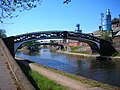
Telford designed a cast iron bridge, the Galton Bridge, to span his cutting. It was cast in the Horseley Iron Works, as was the Engine Arm Aqueduct and many of the wide roving bridges.
In 1837, after Telford's death, a new section of his planned canal was opened together with the 360 yard Coseley Tunnel, complete with double towpath,[1] cutting out the long detour around Coseley and Wednesbury Oak, and therefore relegating it as the Wednesbury Oak Loop. As with many of the branch canals on the BCN, most of the Wednesbury Oak Loop became officially abandoned from 1954, but the northern stretch remains navigable to the British Waterways workshops at Bradley.[8]
By 1838 the New Main Line was complete: 22+5⁄8 miles (36.4 km) of slow canal reduced to 15+5⁄8 miles (25.1 km);[1] between Birmingham and Tipton, it was a lock-free dual carriageway. It was also called the Island Line as it was cut straight through the hill at Smethwick known as the Island.[1]
Later
[edit]In 1892 the Smethwick Engine was replaced by a new pumping house between the old and new canals, just north of Brasshouse Lane Bridge in Smethwick.
Late in the 20th century, a pair of concrete tunnels near Galton Bridge were built to carry the Telford Way road.
Ryland Aqueduct, built in 1836 carrying the canal over the main A461 road at Dudley Port, Tipton, was rebuilt in the late 1960s at a cost of £170,000[9] (equivalent to £3,897,400 in 2023).[10] Demolition of the old aqueduct took place in September 1967.[11] In 1991 at a cost of £22,000 its bare concrete structure was painted blue and white and included a frieze of a narrowboat crossing an old-fashioned brick aqueduct.[12]
The Smethwick Summit - Galton Valley Conservation Area[13] protects the Old and New lines between the Birmingham city boundary and Spon Lane locks.[14]
Features
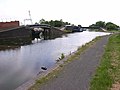
[edit]Junctions
[edit]Other features
[edit]Gallery
[edit]-
 Bridge over Old Main Line in downtown Birmingham
 -
 Two Horsley Ironworks bridges and derelict toll island at Winson Green Junction.
 -
-
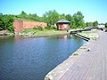 Recently constructed octagonal BCN Toll house at Smethwick top lock.
 -
 The Engine Arm Aqueduct.
 -
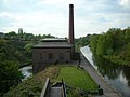 The New Smethwick Pumping Station (restored).
 -
 Galton Bridge and tunnel.
 -
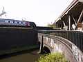 Stewart Aqueduct — Motorway (M5) over rail over canal over canal.
 -
 Bromford Junction - Spon Lane bottom lock visible through one of the Horseley Ironworks bridges.
 -
-


See also
[edit]References
[edit]- ^ a b c d e f g h i j k l m n o p q r Paget-Tomlinson, Edward W. (2006) [1978]. The Illustrated History of Canal & River Navigations. Landmark Publishing Ltd. ISBN 1-84306-207-0.
- ^ a b c d e Smethwick and the BCN, Malcolm D. Freeman, 2003, Sandwell MBC and Smethwick Heritage Centre Trust
- ^ a b c d e f g h i j Hadfield, Charles. Canals of the West Midlands. Newton Abbott: David & Charles.
- ^ Shill, Ray (1999). Birmingham's Canals. Sutton Publishing Ltd. ISBN 0-7509-2077-7.
- ^ "Birmingham's Canal Network - In Brindley's Footsteps". Culture 24. Retrieved 3 August 2019.
- ^ Pearson, Michael (1990). Canal Companion - Midland Rings. J. M. Pearson & Associates. ISBN 0-907864-53-8.
- ^ Collins, Paul (2001). Black Country Canals. Sutton Publishing. ISBN 0-7509-2031-9.
- ^ Pearson, Michael (1989). Canal Companion - Birmingham Canal Navigations. J. M. Pearson & Associates. ISBN 0-907864-49-X.
- ^ "£700,000 aqueduct scheme". Birmingham Daily Post. England. 11 October 1966. Retrieved 30 August 2022 – via British Newspaper Archive.
- ^ UK Retail Price Index inflation figures are based on data from Clark, Gregory (2017). "The Annual RPI and Average Earnings for Britain, 1209 to Present (New Series)". MeasuringWorth. Retrieved 7 May 2024.
- ^ "In memory of a monument". Birmingham Daily Post. England. 1 September 1967. Retrieved 30 August 2022 – via British Newspaper Archive.
- ^ "Frieze Launch". Sandwell Evening Mail. England. 31 August 1991. Retrieved 30 August 2022 – via British Newspaper Archive.
- ^ Sandwell MBC conservation areas Archived 12 June 2008 at the Wayback Machine
- ^ Galton Valley Conservation Area - Review of boundaries Archived 25 July 2011 at the Wayback Machine
- ^ Historic England. "Smethwick New Pumping House (1077154)". National Heritage List for England. Retrieved 23 April 2015.
External links
[edit]BCN Main Line
View on GrokipediaHistory
Construction of the Old Main Line
The Birmingham Canal Company was authorized by an Act of Parliament passed on 24 February 1768, to construct a canal linking Birmingham to Wolverhampton and connecting with the Staffordshire and Worcestershire Canal at Aldersley Junction.[4] The act empowered the company, initially comprising subscribers including prominent local figures, to raise capital through shares totaling approximately £100,000 to fund the project.[5] This financing was secured following a public meeting in Birmingham on 29 January 1767, where sufficient subscriptions were gathered to support the endeavor.[5][6] James Brindley conducted the initial survey in 1767 and was appointed chief engineer, designing the route as a contour canal that closely followed the natural landscape contours to minimize the number of locks and reduce construction costs.[7] His innovative approach emphasized a sinuous path through the hilly Black Country terrain, avoiding steep gradients where possible and relying on the topography to maintain water levels.[8] Construction commenced in 1768, with the first section from Birmingham to the Wednesbury coalfields opening in 1769, allowing immediate coal transport; progress continued with reaches to Tipton in 1770 and Wolverhampton in 1771, culminating in full completion on September 21, 1772.[5] The completed Old Main Line spanned 22.5 miles, featuring 28 locks in total—including six at Smethwick, three at Spon Lane, and 21 descending to the Wolverhampton level—and a summit level approximately 1.75 miles long between key lock flights.[7][9] Key construction challenges included the labor-intensive excavation of deep cuttings and embankments across undulating ground, accomplished using basic hand tools such as picks, shovels, and wheelbarrows by local laborers drawn from the Black Country's mining communities.[5] Brindley's death in September 1772 occurred just weeks before the canal's opening, leaving his assistants to oversee final adjustments.[5] The primary purpose was to facilitate the efficient transport of coal from the Wednesbury coalfields to Birmingham's burgeoning industrial sectors, including metalworking and manufacturing, thereby supporting the region's economic growth during the early Industrial Revolution.[7] Early operations soon revealed water supply shortages on the summit level, necessitating later improvements.[8]Water Supply Challenges and Early Improvements
Following the opening of the Old Main Line in 1772, the canal faced severe water shortages starting in 1773, exacerbated by high evaporation rates on the summit level, intensive lock usage for ascending and descending boats, and unauthorized industrial draw-offs for local factories and mills, which frequently halted navigation and prompted complaints from boat owners and traders.[8][10] In response, engineer John Smeaton conducted a comprehensive survey in 1776, assessing water sources, losses, and distribution along the route, and recommended the installation of side ponds adjacent to locks to reuse water from descending vessels and thus conserve overall supply.[11] His proposals also included the construction of additional reservoirs to feed the summit level via feeder channels, helping to mitigate seasonal deficits from natural streams.[11] Further enhancements in the mid-1780s addressed ongoing capacity issues: a steam-powered pumping station was established at Ocker Hill near Tipton in 1784 to lift water from lower levels, including via a tunnel from the Walsall Canal, directly supplying the summit.[9][5][12] These interventions significantly curtailed operational stoppages and improved reliability amid rising industrial demand in the Black Country, though they also underscored the Old Main Line's inherent limitations in water management for a rapidly expanding network.[8][10]Development of the New Main Line
In 1824, the proprietors of the Birmingham Canal Navigations authorized major improvements to the existing canal system to overcome the inefficiencies of the Old Main Line, including its lengthy loops and frequent locks that hindered traffic flow. Thomas Telford, a renowned civil engineer, was appointed to survey the route and design a more direct alternative from Birmingham to Tipton.[1][13] His report led to the implementation of a lock-free channel to streamline navigation and address persistent water management issues from the earlier route.[1] Telford's design transformed the 22.5-mile Old Main Line into a straighter 15.5-mile New Main Line, employing extensive cuttings and embankments to maintain a consistent summit level at 453 feet above sea level, eliminating the need for locks between Broad Street Basin in Birmingham and Tipton Junction. This engineering approach allowed for wider navigation—accommodating two narrowboats abreast—and integrated seamlessly with the BCN's existing branches, such as those at Smethwick and Oldbury, preserving access to industrial sidings. Construction commenced in 1827, with the initial section from Birmingham to Smethwick Junction opening that year, and the full line to Tipton completed by 1834, at a total cost of £300,000 funded by the canal proprietors.[3][1] Key construction challenges included massive earthworks, exemplified by the Smethwick cutting, a 2.5-mile excavation reaching depths of 70 feet through clay and rock, which required innovative techniques like gunpowder blasting to remove over a million cubic yards of material. These efforts created a bold, straight channel that bypassed the Old Main Line's summits and loops, with the spoil used to build adjacent embankments for stability. The New Main Line's completion marked a pinnacle of early 19th-century canal engineering, enhancing the network's capacity without disrupting ongoing operations.[1] Upon opening, the New Main Line dramatically improved transit efficiency, shortening the distance by seven miles and enabling lock-free passage that reduced journey times from several days on the congested Old Main Line to under a single day for goods boats. This acceleration boosted coal shipments from Black Country mines and other freight to Birmingham's burgeoning factories, significantly increasing annual tonnage and economic throughput on the BCN system. The improvements solidified the canal's role as a vital artery for industrial Britain, with traffic volumes rising markedly in the ensuing years.[3][14]Later Developments and Modern Era
In the mid-19th century, the Birmingham Canal Navigations (BCN) underwent expansions to handle growing industrial traffic.[15] Steam tugs replaced horse haulage on busier stretches and improved towing efficiency for narrowboats.[16] These modifications sustained the canal's role as a vital artery for the Black Country's iron, coal, and manufacturing industries. Traffic on the BCN Main Line peaked in the 1880s, with annual tonnage reaching nearly 8 million tons, driven by heavy freight in coal, iron, and limestone.[17][18] However, post-World War II, usage declined sharply due to competition from railways and expanding road networks, including surplus military lorries repurposed for haulage, leading to reduced commercial viability by the 1950s.[19] The system was nationalized in 1948 under the British Transport Commission, later managed by British Waterways, which oversaw a network strained by maintenance challenges and shifting economic priorities.[20] The 1960s brought closure threats amid proposals to abandon underused waterways, with partial infilling of branches and loops occurring as commercial traffic dwindled further.[19] Advocacy by the Inland Waterways Association and local campaigns prevented full abandonment, emphasizing recreational potential and leading to key restorations in the 1970s and 1980s, including upgrades around Smethwick such as the 1974 pedestrianization of Galton Bridge and improvements to the summit section.[8] These efforts, supported by volunteer groups, restored navigability and integrated the canals into urban regeneration projects. As of November 2025, the BCN Main Line is fully navigable and managed by the Canal & River Trust, which assumed responsibility from British Waterways in 2012, focusing on leisure boating, heritage preservation, and environmental maintenance.[21] Ongoing works include dredging, lock repairs, and flood risk management, with the waterway supporting thousands of recreational users annually while contributing to local biodiversity and urban green corridors.[22]Route and Engineering
Old Main Line Route
The Old Main Line of the Birmingham Canal Navigations begins at Gas Street Basin in central Birmingham, serving as the eastern terminus of the original route engineered by James Brindley and authorized in 1768. From here, the canal initially follows a relatively level path through the emerging industrial landscape of the city, navigating urban wharves and early manufacturing districts before reaching the Smethwick area approximately 3 miles west. The route's topography in this initial segment is characterized by gentle undulations, with the canal hugging low-lying ground to avoid major cuttings or embankments, reflecting Brindley's preference for contour-following construction to minimize earthworks.[7][8] At Smethwick, the canal encounters its first major engineering challenge, ascending from the Birmingham Level (approximately 453 feet above sea level) to the Wolverhampton Level at 473 feet via an original flight of 6 locks, constructed between 1769 and 1772. This ascent, covering about 0.5 miles, marked a departure from Brindley's ideal level route due to unexpected rises in the terrain, with each lock raising the water by around 3-4 feet to accommodate the 20-foot elevation gain. Beyond the Smethwick flight, the canal enters a 3-mile contour pound at the summit level, meandering through the industrial Black Country with its coal mines and forges; this section, roughly 5 miles long to Tipton Factory Junction, winds along natural contours, crossing aqueducts like the Tividale Aqueduct over the Netherton Tunnel Branch and passing junctions such as Spon Lane and Oldbury. The path here avoids deep excavations by curving around hills, traversing a landscape of factories and collieries that the canal was designed to serve.[7][2][23] From Tipton Factory Junction, the summit pound continues for another 7-8 miles westward, maintaining the 473-foot level through segments like the Bradley Branch junction and the urbanizing areas near Bilston and Coseley, where the canal skirts spoil heaps and early ironworks. This extended level stretch, free of locks, exemplifies Brindley's contour method, allowing efficient passage for coal-laden boats while following the topography to limit construction costs. The route culminates at the eastern end of Wolverhampton, approximately 22.5 miles from the start, where it meets the 21-lock flight descending to Aldersley Junction on the Staffordshire and Worcestershire Canal. Overall, the Old Main Line's meandering 22.5-mile path prioritized minimal intervention in the hilly terrain, resulting in a lock-heavy ascent at one end but a prolonged summit pound that facilitated trade; today, much of it is paralleled by urban development and roads, though side ponds at the Smethwick locks helped conserve water during its operational peak. Today, much of the Old Main Line has been superseded by the New Main Line or fallen into disuse, with approximately 6.6 miles of its 13.4-mile remaining length navigable.[8][23][7][8]New Main Line Route
The New Main Line originates at Gas Street Basin in central Birmingham and proceeds westward in a predominantly straight alignment to Tipton, covering a total distance of approximately 15 miles.[3] This engineered route, constructed between 1827 and 1838 under the direction of Thomas Telford, eliminates the numerous locks and contours of the original path, maintaining the Birmingham summit level of 453 feet above ordnance datum for about 11.5 miles to facilitate efficient through-traffic of goods and barges.[3] By lowering the level 20 feet below Brindley's original design and employing extensive cuttings from the outset, it avoids early locks and shortens the journey by roughly 7 miles compared to the Old Main Line.[1] A prominent feature is the immediate entry into deep cuttings, reaching up to 30 feet in initial sections near the basin to preserve the level without hydraulic interruptions, followed by the expansive Smethwick Cutting—a 2-mile-long excavation averaging 30 to 70 feet deep at its maximum, which bypasses the former Smethwick Summit.[1] The route traverses the Galton Valley, supported by bold embankments and structures like the cast-iron Galton Bridge spanning 150 feet, before crossing the A461 road on the Ryland Aqueduct, a brick structure rebuilt in 1968 to carry the canal over the road below.[3] These elements underscore the line's emphasis on direct progression and minimal deviation, integrating seamlessly with the broader BCN network. The canal remains lock-free until its terminus at Tipton, where it junctions with the Old Main Line via the three Factory Locks, which ascend approximately 20 feet to reach the higher Dudley Level at 473 feet, enabling connection to the original summit contour for onward travel toward Wolverhampton.[1] Engineered with a channel width accommodating beams up to 14 feet for larger narrow-beam barges and a draught of 4 feet 4 inches, the New Main Line prioritized capacity for industrial traffic, including coal and manufactured goods.[1] Today, it functions primarily as a leisure navigation route, popular for boating and waterside paths, with few obstacles beyond occasional maintenance and a 4 mph speed limit to preserve its banks and heritage structures.[3]Key Engineering Features
The BCN Main Line is renowned for its innovative engineering solutions to challenging topography and water supply issues, particularly in the Smethwick area, where Thomas Telford's redesign of the route incorporated deep cuttings and advanced structures to create a more direct and efficient waterway. The Smethwick Cuttings, excavated between 1827 and 1832 under Telford's supervision, form a key element of the New Main Line, reaching depths of up to 71 feet (22 meters) to maintain the 453-foot (138-meter) Birmingham level without locks. These cuttings bypassed the original summit locks on the Old Main Line, allowing for faster transit and greater capacity for industrial traffic; the excavation work represented one of the largest earth-moving projects of the early 19th century in British canal engineering.[1] Within the Smethwick Cuttings lies the Galton Tunnel, a 103-yard (94-meter) brick-lined passage completed in 1829 as part of Telford's improvements to the New Main Line. This short tunnel facilitated the level passage through the hillside, minimizing deviations from the straight alignment and demonstrating precise hand-excavation techniques typical of the period. Complementing the cuttings is the Galton Bridge, a pioneering cast-iron trough aqueduct spanning 150 feet (46 meters) over the excavation, built in 1829 to carry a local road above the canal; its single-arch design and use of prefabricated iron sections marked an early advancement in lightweight, durable bridge construction for waterways.[24][3] Water management structures were equally critical to the Main Line's operation, addressing the summit level's high evaporation and lockage demands through mechanical pumping and feeder systems. At Smethwick, the Engine Arm branch featured beam engines installed from the late 1770s to the 1820s, with the landmark Smethwick Engine—designed by James Watt and built by Boulton & Watt in 1779—pumping water uphill from below the locks to replenish the summit pound at a rate of up to 144 strokes per minute. This rotative steam engine, preserved today as a museum piece, was among the first to incorporate expansive steam use for greater efficiency and operated continuously until the 1890s. Supporting these efforts, the Netherton Reservoir, constructed in the 1830s and opened in 1838, served as a vital feeder for both the Old and New Main Lines, storing rainwater to maintain levels across the BCN network amid industrial growth.[25][26] Aqueducts further exemplified the line's engineering ingenuity, crossing roads and other obstacles without interrupting navigation. The Engine Arm Aqueduct, completed in 1829 by Telford, carries the feeder arm over the deep Smethwick Cutting on the New Main Line using a cast-iron trough supported by brick arches, ensuring uninterrupted water supply while showcasing economical use of iron for elevated crossings. These features collectively enabled the Main Line to handle heavy coal and goods traffic, underscoring Telford's influence in transforming Brindley's contour-following design into a more ambitious, straight-line infrastructure.[27]Connections and Significance
Major Junctions
The BCN Main Line begins at Gas Street Basin in central Birmingham, serving as a primary hub for canal traffic entering the network from the south. This basin connects directly to the Icknield Port Loop, providing access to industrial wharves and further branches, while the adjacent Farmers Bridge flight of 13 locks links northward to the Grand Union Canal via the Birmingham & Fazeley Canal.[28][21] Approximately 2.6 miles northwest of the basin lies Smethwick Junction, the critical divergence point where the original Old Main Line, constructed by James Brindley, separates from Thomas Telford's later New Main Line improvements of the 1820s. This junction facilitates navigation choices, with the Old Main Line route incorporating Smethwick Locks to connect indirectly through the broader BCN system to branches like the Stratford-upon-Avon Canal, enhancing regional linkages for goods transport.[28][8] Further along, Tipton Junction marks the convergence of the Old and New Main Lines, approximately 6 miles from Birmingham, and provides essential access to the Dudley Tunnel on the Dudley Canal No. 1 as well as the Netherton Tunnel Branch, which opened in 1858 and extends 1.75 miles to relieve congestion in the industrial Black Country. Nearby Factory Junction provides access to extensive branches including the Wednesbury Old Canal and other industrial arms. This site was pivotal for integrating multiple branches into the main route.[28][29][21] The Main Line terminates at Wolverhampton, where Broad Street Basin acts as the northern endpoint and interchange point, from where a 21-lock flight descends 132 feet (40 m) to connect with the Staffordshire & Worcestershire Canal at Aldersley Junction. This flight, part of the Wolverhampton Locks, was essential for linking the BCN to northern and western waterways and supporting heavy industrial traffic.[28][30] These major junctions collectively underpin the BCN's expansive 100-mile network of interconnected canals, enabling efficient movement of coal and iron from the Black Country coalfields and forges to markets in Birmingham and beyond during the Industrial Revolution.[21]Economic and Cultural Impact
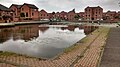
The BCN Main Line played a pivotal role in fueling the Industrial Revolution by providing an efficient transport network for coal from the Black Country's mines to Birmingham's burgeoning metalworking industries, enabling the rapid expansion of manufacturing in the region.[14] Constructed in the 1770s, the canal system drastically reduced coal transport costs, stimulating mining operations and supporting the growth of ironworking and other heavy industries that defined the area's economic landscape.[31] By the late 19th century, the BCN had reached its peak, carrying approximately 8.5 million tons of goods annually, with over half comprising coal destined for Birmingham's factories.[32] At its height before World War I, the canal network handled millions of tons of freight, underscoring its dominance in regional logistics despite emerging competition from railways.[33] However, post-1945, the shift toward road and rail transport for bulk goods led to a sharp decline in commercial usage, with coal demand waning and many branches falling into dereliction by the 1960s, symbolizing the end of the canal era's industrial prominence.[34] This transition marked a broader economic realignment in the West Midlands, as the once-vital waterway infrastructure became obsolete for heavy freight. In the modern era, the BCN Main Line holds significant heritage value as part of the Black Country UNESCO Global Geopark, recognized since 2020 for its outstanding geological and industrial legacy, including the dense network of canals that powered 19th-century innovation.[35] Leisure boating has revitalized the system, with thousands of narrowboats and hire craft navigating its routes each year, contributing to tourism and local economies through boat rentals and visitor facilities.[21] Cultural events, such as the annual Brownhills Canal Festival and the BCN 24-Hour Marathon Challenge, draw enthusiasts to celebrate the waterways' history with boat parades, live music, and educational displays.[36] The Main Line's legacy endures in shaping urban development, as its infrastructure influenced the layout of industrial towns and factories along its banks, fostering the interconnected economic hubs of Birmingham and the Black Country. Today, former towpaths serve as vital greenways, offering traffic-free routes for walking and cycling that integrate into Birmingham's broader network of over 150 miles of paths, promoting health, recreation, and environmental connectivity.[37][38]References
- https://en.wikisource.org/wiki/The_Canal_System_of_England/The_Canal_System_of_England