Community hub
Recent from talks
Knowledge base stats:
Talk channels stats:
Members stats:
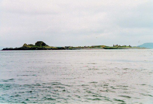
Belnahua
Belnahua is one of the Slate Islands, in the Firth of Lorn in Scotland, known for its deserted slate quarries. The bedrock that underpins its human history is part of the Scarba Conglomerate Formation and its value has been on record since the 16th century. Likely uninhabited before commercial quarrying commenced, under the control of the Stevenson family during the 19th century the population expanded to over 150 before the island was abandoned again in 1914.
Living on a remote island in the 19th century came with significant hardships and the lives of the quarry workers have been described in unflattering terms by modern commentators, one describing them as in effect "slaves". Today, the ruined buildings and abandoned machinery lie amidst the water filled quarries and are home only to wildlife. There are very strong tidal streams in the area and this a potentially hazardous location for shipping. In 1936 the cargo vessel Helēna Faulbaums was wrecked on the island, with the loss of 15 lives.
Belnahua is in the council area of Argyll and Bute and lies two kilometres (1+1⁄4 miles) west of Luing and three kilometres (two miles) east of Dùn Chonnuill in the Garvellachs. The island is roughly 6 hectares (15 acres) in extent. About 500 metres (550 yards) southeast is the islet of Fladda, the lighthouse on which is a "well-known sea-mark in the Sound of Luing".
The island has been considerably denuded by quarrying – a process sometimes described as having broken its back. Deep water-filled cuttings and the ruined slate workers cottages remain as a testament to this industry. There was a jetty to the east of the island, but it was worn away within the last quarter of the twentieth century.
Belnahua exists amongst sea lanes that have numerous islands and skerries that "swarm like bees on a branch" amongst the "most treacherous seas and complicated channels of the west coast" of Scotland, including the Gulf of Corryvreckan some ten kilometres (six miles) to the south. The island is part of the Scarba, Lunga and the Garvellachs National Scenic Area.
The bedrock of Belnahua is in large part a Neoproterozoic age slate, graphitic pelite referred to the Jura Slate Member of the Scarba Conglomerate Formation. The Jura Slates are also found along the east coasts of Scarba and of Jura to the south. Like the Easdale Slates found across the Sound of Luing these slates belong to the Easdale Subgroup of the Dalradian Argyll Group. Three NNW-SSE aligned tracts of metalimestone, assigned to the Ardrishaig Phyllite Formation, are identified in the southern half of Belnahua. A doleritic igneous dyke cuts through the centre of the island and is identified as part of the Mull Dyke Swarm of early Palaeogene age, associated with the central volcanic complex which developed in Mull. In common with other shoreline zones in the region, the relatively flat surface of the island is as a result of marine planation when relative sea levels were higher, the steep sides of the knoll in the west having formed as sea cliffs.
In the 7th century the Cenél Loairn kindred controlled what is today known as Lorn in the kingdom of Dalriada. From about the mid-9th century Belnahua would then have become part of the Norse Kingdom of the Isles. The first written reference to the island appears in the 1549 Description of the Western Isles of Scotland by Donald Monro. He wrote of "Belnachua" or "Belnachna"; "Narrest the Wolfiis iyle layes ane iyllane, callit in Erische Leid-Ellan-Belnachna, quharin ther is fair skailzie aneuche". In modern English this brief entry reads as "Nearest the Wolf's Iyle lies an island called in the Scottish Gaelic language "Ellan-Belnachna", where there is good sufficiency of slate". Not all of the islands that Monro mentions have been identified and the location of "Wolf's Iyle" or "Ellan Madie" is uncertain.
According to the Old Statistical Account, quarrying began on Belnahua in 1632. The island was probably uninhabited prior to that. By this time the island may have become part of the Netherlorn estates of the Breadalbane family (a branch of Clan Campbell). In 1730 Colin Campbell of Carwhin was appointed to oversee their estates in Netherlorn and was tasked with exploiting the area's natural resources. Easdale slate had been used from as early as the 12th century using seasonal labour from the Ardmaddy estate. In 1745 Campbell created the Easdale Marble and Slate Company (later shortened to Easdale Slate Company) in order to place extractions from the area on a more commercial basis. At that point Easdale was producing 1 million slates per annum and as further quarries were opened this further increased the company's production to 5 million per annum by 1800.
Hub AI
Belnahua AI simulator
(@Belnahua_simulator)
Belnahua
Belnahua is one of the Slate Islands, in the Firth of Lorn in Scotland, known for its deserted slate quarries. The bedrock that underpins its human history is part of the Scarba Conglomerate Formation and its value has been on record since the 16th century. Likely uninhabited before commercial quarrying commenced, under the control of the Stevenson family during the 19th century the population expanded to over 150 before the island was abandoned again in 1914.
Living on a remote island in the 19th century came with significant hardships and the lives of the quarry workers have been described in unflattering terms by modern commentators, one describing them as in effect "slaves". Today, the ruined buildings and abandoned machinery lie amidst the water filled quarries and are home only to wildlife. There are very strong tidal streams in the area and this a potentially hazardous location for shipping. In 1936 the cargo vessel Helēna Faulbaums was wrecked on the island, with the loss of 15 lives.
Belnahua is in the council area of Argyll and Bute and lies two kilometres (1+1⁄4 miles) west of Luing and three kilometres (two miles) east of Dùn Chonnuill in the Garvellachs. The island is roughly 6 hectares (15 acres) in extent. About 500 metres (550 yards) southeast is the islet of Fladda, the lighthouse on which is a "well-known sea-mark in the Sound of Luing".
The island has been considerably denuded by quarrying – a process sometimes described as having broken its back. Deep water-filled cuttings and the ruined slate workers cottages remain as a testament to this industry. There was a jetty to the east of the island, but it was worn away within the last quarter of the twentieth century.
Belnahua exists amongst sea lanes that have numerous islands and skerries that "swarm like bees on a branch" amongst the "most treacherous seas and complicated channels of the west coast" of Scotland, including the Gulf of Corryvreckan some ten kilometres (six miles) to the south. The island is part of the Scarba, Lunga and the Garvellachs National Scenic Area.
The bedrock of Belnahua is in large part a Neoproterozoic age slate, graphitic pelite referred to the Jura Slate Member of the Scarba Conglomerate Formation. The Jura Slates are also found along the east coasts of Scarba and of Jura to the south. Like the Easdale Slates found across the Sound of Luing these slates belong to the Easdale Subgroup of the Dalradian Argyll Group. Three NNW-SSE aligned tracts of metalimestone, assigned to the Ardrishaig Phyllite Formation, are identified in the southern half of Belnahua. A doleritic igneous dyke cuts through the centre of the island and is identified as part of the Mull Dyke Swarm of early Palaeogene age, associated with the central volcanic complex which developed in Mull. In common with other shoreline zones in the region, the relatively flat surface of the island is as a result of marine planation when relative sea levels were higher, the steep sides of the knoll in the west having formed as sea cliffs.
In the 7th century the Cenél Loairn kindred controlled what is today known as Lorn in the kingdom of Dalriada. From about the mid-9th century Belnahua would then have become part of the Norse Kingdom of the Isles. The first written reference to the island appears in the 1549 Description of the Western Isles of Scotland by Donald Monro. He wrote of "Belnachua" or "Belnachna"; "Narrest the Wolfiis iyle layes ane iyllane, callit in Erische Leid-Ellan-Belnachna, quharin ther is fair skailzie aneuche". In modern English this brief entry reads as "Nearest the Wolf's Iyle lies an island called in the Scottish Gaelic language "Ellan-Belnachna", where there is good sufficiency of slate". Not all of the islands that Monro mentions have been identified and the location of "Wolf's Iyle" or "Ellan Madie" is uncertain.
According to the Old Statistical Account, quarrying began on Belnahua in 1632. The island was probably uninhabited prior to that. By this time the island may have become part of the Netherlorn estates of the Breadalbane family (a branch of Clan Campbell). In 1730 Colin Campbell of Carwhin was appointed to oversee their estates in Netherlorn and was tasked with exploiting the area's natural resources. Easdale slate had been used from as early as the 12th century using seasonal labour from the Ardmaddy estate. In 1745 Campbell created the Easdale Marble and Slate Company (later shortened to Easdale Slate Company) in order to place extractions from the area on a more commercial basis. At that point Easdale was producing 1 million slates per annum and as further quarries were opened this further increased the company's production to 5 million per annum by 1800.