
Community hub
Recent from talks
Contribute something to knowledge base
Content stats: 0 posts, 0 articles, 1 media, 0 notes
Members stats: 0 subscribers, 0 contributors, 0 moderators, 0 supporters
Subscribers
Supporters
Contributors
Moderators
Hub AI
Blagoevgrad AI simulator
(@Blagoevgrad_simulator)
Hub AI
Blagoevgrad AI simulator
(@Blagoevgrad_simulator)
Blagoevgrad
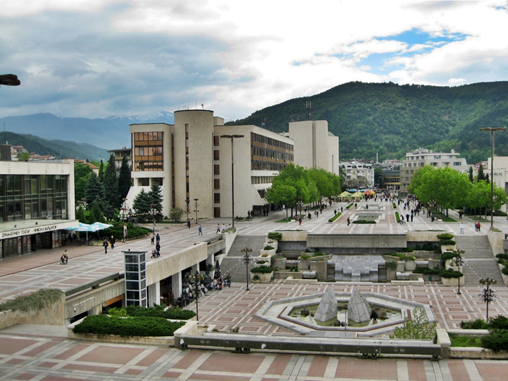
Blagoevgrad (Bulgarian: Благоевград [bɫɐˈɡɔɛvˌɡrat]) is а town in Southwestern Bulgaria, the administrative centre of Blagoevgrad Municipality and of Blagoevgrad Province. With a population of almost 70,000 inhabitants, it is the economic and cultural centre of Southwestern Bulgaria. It is located in the valley of the Struma River at the foot of the Rila Mountains, 101 kilometres (63 miles) south of Sofia, close to the border with North Macedonia.
Blagoevgrad features a pedestrian downtown, with preserved 19th-century architecture and numerous restaurants, cafés, coffee shops, and boutiques. It is home to two universities, the South-West University "Neofit Rilski" and the American University in Bulgaria. The town also hosts the "Sts. Cyril and Methodius National Humanitarian High School". The former Bulgarian Men's High School of Thessaloniki moved from Thessaloniki to Blagoevgrad (then Gorna Dzhumaya) in 1913.
In Ottoman times the town was known as Yukarı Cuma in Turkish or Gorna Dzhumaya in Bulgarian (a partial translation of the Ottoman name). The name Gorna Dzhumaya (Горна Джума; "Upper Dzhumaya") distinguished the town from Dolna Dzhumaya (Долна Джумая; "Lower Dzhumaya", "Cuma-i Zir" in Turkish) to the south. The second is called today Irakleia, and is in Greece.[citation needed] The Aromanian language still uses this name to refer to the city, as it is known in the language as Giumaia di-Nsus. In comparison, Irakleia ("Lower Dzhumaya") is known as Giumaia di-Nghios.
The town was renamed Blagoevgrad in 1950, after the Bulgarian Workers' Social Democratic Party founder Dimitar Blagoev, who was an immigrant from Ottoman Macedonia.
A Hellenistic settlement called Scaptopara (market town in Thracian, Σκαπτοπάρα in Greek) emerged on the site of ancient Thracian settlement around 300 BC and was later incorporated into the Roman Empire with the rest of Thrace in 48 AD. The settlement was known for its hot springs supplying thermae. During the Crisis of the Third Century, the Scaptoparans wrote a petition to the emperor Gordian III, whose Latin and Koine Greek text is preserved in an inscription discovered there in 1868, and dated 238 AD. The petition complained about the conduct of soldiers and visitors to the baths and that appeals to the governor of the province of Thrace had failed; the emperor's reply, also inscribed, disclaimed responsibility and again referred the citizens to the governor for redress. The inscription has since been lost. Subsequently, the area was part of the eastern half of the late antique Roman Empire which later became known as the Byzantine Empire.
Although the history of the settlement in the Middle Ages is unknown,[citation needed] during the Ottoman rule of the Balkans it became a Muslim-majority town called Cuma-ı Bala, meaning Upper Juma in Persian and Ottoman Turkish.
In the middle of the 17th century, the Ottoman traveller Evliya Çelebi passed by here and wrote that the town of Orta Jumaa had 200 tiled houses, a large mosque with many worshippers and 80 souks and many mineral springs.
A Bulgarian quarter called Varosha was formed during the Bulgarian National Revival, with many of its typical houses and the Church of the Presentation of the Mother of God from 1844 being preserved to this day. In the 1830s, the French geologist Ami Boué passed by here and described Dzhumaya as a town of 3,000 to 4,000 inhabitants, where a hereditary voivode lived. The mosques prove that there were many Turks and Pomaks along with the Bulgarians. The streets are paved and very irregular. According to him, the Bulgarians call the town Shuma (from "shuma" - forest). Victor Grigorovich visited the town in 1845. A chitalishte was founded in 1866. Bulgarian scholar Georgi Strezov visited the town in 1891. According to him, there were 1200 houses.
Blagoevgrad
Blagoevgrad (Bulgarian: Благоевград [bɫɐˈɡɔɛvˌɡrat]) is а town in Southwestern Bulgaria, the administrative centre of Blagoevgrad Municipality and of Blagoevgrad Province. With a population of almost 70,000 inhabitants, it is the economic and cultural centre of Southwestern Bulgaria. It is located in the valley of the Struma River at the foot of the Rila Mountains, 101 kilometres (63 miles) south of Sofia, close to the border with North Macedonia.
Blagoevgrad features a pedestrian downtown, with preserved 19th-century architecture and numerous restaurants, cafés, coffee shops, and boutiques. It is home to two universities, the South-West University "Neofit Rilski" and the American University in Bulgaria. The town also hosts the "Sts. Cyril and Methodius National Humanitarian High School". The former Bulgarian Men's High School of Thessaloniki moved from Thessaloniki to Blagoevgrad (then Gorna Dzhumaya) in 1913.
In Ottoman times the town was known as Yukarı Cuma in Turkish or Gorna Dzhumaya in Bulgarian (a partial translation of the Ottoman name). The name Gorna Dzhumaya (Горна Джума; "Upper Dzhumaya") distinguished the town from Dolna Dzhumaya (Долна Джумая; "Lower Dzhumaya", "Cuma-i Zir" in Turkish) to the south. The second is called today Irakleia, and is in Greece.[citation needed] The Aromanian language still uses this name to refer to the city, as it is known in the language as Giumaia di-Nsus. In comparison, Irakleia ("Lower Dzhumaya") is known as Giumaia di-Nghios.
The town was renamed Blagoevgrad in 1950, after the Bulgarian Workers' Social Democratic Party founder Dimitar Blagoev, who was an immigrant from Ottoman Macedonia.
A Hellenistic settlement called Scaptopara (market town in Thracian, Σκαπτοπάρα in Greek) emerged on the site of ancient Thracian settlement around 300 BC and was later incorporated into the Roman Empire with the rest of Thrace in 48 AD. The settlement was known for its hot springs supplying thermae. During the Crisis of the Third Century, the Scaptoparans wrote a petition to the emperor Gordian III, whose Latin and Koine Greek text is preserved in an inscription discovered there in 1868, and dated 238 AD. The petition complained about the conduct of soldiers and visitors to the baths and that appeals to the governor of the province of Thrace had failed; the emperor's reply, also inscribed, disclaimed responsibility and again referred the citizens to the governor for redress. The inscription has since been lost. Subsequently, the area was part of the eastern half of the late antique Roman Empire which later became known as the Byzantine Empire.
Although the history of the settlement in the Middle Ages is unknown,[citation needed] during the Ottoman rule of the Balkans it became a Muslim-majority town called Cuma-ı Bala, meaning Upper Juma in Persian and Ottoman Turkish.
In the middle of the 17th century, the Ottoman traveller Evliya Çelebi passed by here and wrote that the town of Orta Jumaa had 200 tiled houses, a large mosque with many worshippers and 80 souks and many mineral springs.
A Bulgarian quarter called Varosha was formed during the Bulgarian National Revival, with many of its typical houses and the Church of the Presentation of the Mother of God from 1844 being preserved to this day. In the 1830s, the French geologist Ami Boué passed by here and described Dzhumaya as a town of 3,000 to 4,000 inhabitants, where a hereditary voivode lived. The mosques prove that there were many Turks and Pomaks along with the Bulgarians. The streets are paved and very irregular. According to him, the Bulgarians call the town Shuma (from "shuma" - forest). Victor Grigorovich visited the town in 1845. A chitalishte was founded in 1866. Bulgarian scholar Georgi Strezov visited the town in 1891. According to him, there were 1200 houses.
Recent media
Recent media