Hubbry Logo
BluestonehengeBluestonehengeMain
Open search
Bluestonehenge
Community hub
Bluestonehenge
logo
8 pages, 0 posts
0 subscribers
Be the first to start a discussion here.
Bluestonehenge
Bluestonehenge
from Wikipedia

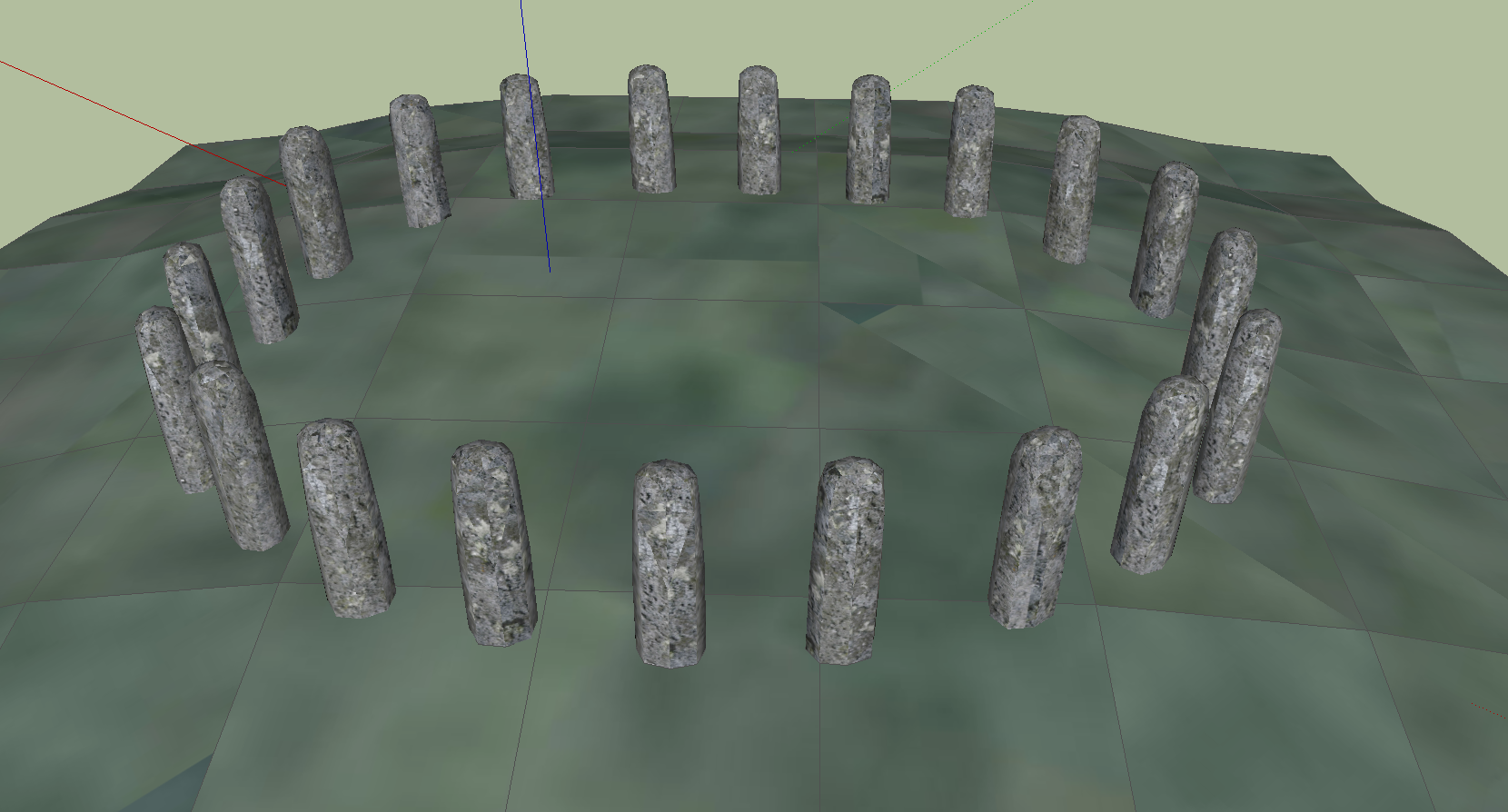
Bluestonehenge or Bluehenge (also known as West Amesbury Henge[1]) is a prehistoric henge and stone circle monument that was discovered by the Stonehenge Riverside Project about 1 mile (1.6 km) south-east of Stonehenge in Wiltshire, England.[2] All that remains of the site is the ditch of the henge and a series of stone settings, none of which is visible above ground.

Key Information

Excavations

[edit]

The site was excavated in August 2008 and again in August 2009; it is considered to be an important find by archaeologists.[3] Full details of the discovery were published in the 2010 January / February edition of British Archaeology.[4]

Mike Parker Pearson and his team of researchers played a key role in the discovery of this new henge site along the River Avon that links to Stonehenge. This new site was uncovered through excavation during the Stonehenge Riverside Project;[5] it was given the name "Bluestonehenge" or "Bluehenge" because traces of bluestones were found during the excavation.

The term “henge” is often incorrectly thought to mean a circular structure of stones.[6] In fact, henge in archaeology refers to an enclosed structure made of compressed earth, containing a ditch on the inside of the bank, giving the perception of keeping something inside the enclosure, rather than keeping out others. Stonehenge may be improperly named, according to the original archeological definition, as its ditch is located on the outside of the bank.[7]

Initial findings

[edit]

The monument has been tentatively dated to between about 3000 and 2400 BC. Radiocarbon dating of antler tools found at the site has provided only an approximate date of 2469 to 2286 BC for the dismantling of the stones.[8] Tests on an antler pick found at the bottom of a stonehole have so far failed, due to inadequate collagen in the sample.[9][10]

Excavation revealed several stone settings that are thought to have been erected some time between 3400 and 2500 BC, due to two flint chisel arrowheads being found that are in a style commonly used during that period. It is estimated that there may have been as many as 27 stones in a circle 33 feet (10 m) in diameter. Charcoal was found in some holes, suggesting that burning may have taken place there.[11] One suggestion is that the henge was a site for cremations.[10] Within the stone circle there were imprints of the bases from the original stones, which have been compared to the bluestones located in Stonehenge and have been found to have matching dimensions.[original research?]

The name "Bluestonehenge" is derived from the discovery of small stone chips in some of the stone settings. These bluestones are also found in Stonehenge and consist of a wide range of rock types originally from Pembrokeshire, west Wales, some 150 miles (240 km) away.[3] Archaeologist Mike Parker Pearson suspects that any bluestones in the circle may have been removed around 2500 BC and incorporated into Stonehenge, which underwent major rebuilding work at about that time.[10]

The stone circle settings were surrounded by a henge, comprising an 82-foot-wide (25 m) ditch and outer bank which appears to date from approximately 2400 BC.[10] Unlike Stonehenge, this monument does not appear to have any significant solar or lunar orientations.[11]

Context

[edit]
The River Avon near the site of Bluestonehenge

The henge is located beside the River Avon in West Amesbury. Immediately beside it is the Avenue, a linear ditch and bank route that leads to Stonehenge.[3][11] Mike Parker Pearson has suggested that the site may have been used for ceremonial purposes – possibly as a stopping place along a routeway between Durrington Walls and Stonehenge.[11]

It is thought that it was a ceremonial route from an area of life at Durrington Walls, through Bluestonehenge and along the "Stonehenge Avenue", to arrive at the site of an individual's final resting place in Stonehenge. This theory can be supported by the numerous cremation burials (over 200)[12] that have been uncovered during excavation work around Stonehenge. Analysis of these remains also leads researchers to believe it was a ceremony for the wealthier in the region, or of royal lineage, or even for those who helped initiate construction of Stonehenge. This select group of individuals was believed to be male adults who were 25–40 years old and who seemed quite healthy.

Mike Parker Pearson's past experience working with a colleague from Madagascar also helped to shape his theory. He believes that the choice of stone material for Stonehenge is significant. Past civilizations often reserved stone for construction of their ancestors' tombs, while the perishable material, such as the wood used for the Durrington Walls timber circles, was reserved for the living. Parker Pearson believes that Durrington Walls may have been a "land of the living" while Stonehenge (which was Britain's largest known cemetery at the time[10]) was a "domain of the dead".[original research?]

See also

[edit]

References

[edit]
[edit]
Revisions and contributorsEdit on WikipediaRead on Wikipedia
from Grokipedia
Bluestonehenge is a monument and dismantled located on the west bank of the River Avon in , , approximately 1.5 miles (2.4 km) southeast of . Discovered in 2009 during excavations by the Stonehenge Riverside Project—a collaborative effort involving archaeologists from the Universities of Sheffield, Bristol, and Manchester—it originally featured around 25 bluestone orthostats, each about 2 meters tall, arranged in a circle roughly 10 meters in diameter, surrounded by a comprising a ditch and external bank. The bluestones, sourced from the Preseli Hills in , , over 140 miles (225 km) away, were erected around 3000 BC, predating the henge's construction circa 2400 BC by several centuries; the monument was likely dismantled between 2469 and 2270 BC, with its stones possibly relocated to during its major rebuilding phase around 2500 BC. The site marks the southeastern terminus of the Stonehenge Avenue, a 1.7-mile (2.7 km) processional route aligned with the midsummer solstice sunrise, linking the River Avon—a Neolithic conduit symbolizing transitions between —to itself, which project leaders interpret as a "domain of the dead" focused on ancestral and funerary rituals. Archaeological evidence from the excavations includes stoneholes with ramps and antler picks for stone erection, fragments of , tools such as chisel arrowheads, and pottery, alongside radiocarbon dates confirming its chronology within the late Neolithic to early transition. Experts suggest Bluestonehenge served as a ceremonial hub, potentially for processing before ashes were transported upstream to for , enhancing understanding of the broader ritual landscape that connected "domains of the living" at nearby to mortuary practices. Since its discovery, Bluestonehenge has reshaped interpretations of 's and symbolism, underscoring the deliberate long-distance of Welsh bluestones as a key element of cosmology and . Further analysis, including geophysical surveys and periglacial feature studies, has revealed the Avenue's later recutting around 2250–2135 BC, reinforcing its ongoing sacred role, while the site's integration into the UNESCO-listed , and Associated Sites World Heritage property highlights its enduring archaeological value.

Site Overview

Location and Geography

Bluestonehenge, also known as West Amesbury Henge, is situated at grid reference SU 1423 4137, corresponding to coordinates 51°10′17″N 1°47′53″W, approximately 1.6 km southeast of the main monument in , . The site lies directly beside the River Avon, at the eastern terminus of the Stonehenge Avenue, a linear earthwork connecting it to the larger complex about 2.8 km to the northwest. This positioning integrates Bluestonehenge into the broader , and Associated Sites World Heritage property, recognized for its prehistoric monuments spanning the Stonehenge landscape. The surrounding landscape during the period (c. 3000–2400 BC) consisted of a environment along the River Avon, characterized by open grasslands and limited woodland cover following early . The site's selection likely reflected the accessibility provided by the river, which facilitated potential waterborne transportation routes for materials and people in the region, contrasting with the drier uplands nearby. activity dating to the 8th–5th millennium cal BC at nearby Blick Mead further underscores the long-term human use of this riverine setting. Geologically, Bluestonehenge occupies Plain's downlands, with underlying bedrock featuring periglacial stripes—shallow fissures up to 0.5 m deep and 0.4 m wide—that supported lusher in an otherwise exposed . Natural ridges, approximately 6 m wide, and erosion on the site's southern side influenced its placement and preservation, embedding it within a dynamic prone to seasonal flooding. This - interface provided a stable yet hydrologically active foundation, integral to the monument's environmental context during its construction and use.

Monument Description

Bluestonehenge is a prehistoric circular monument consisting of a and internal bank enclosing a smaller . The henge measures approximately 30 meters in diameter, with the varying from 2.6 meters wide and 1.2 meters deep in a V-shaped profile, while the bank, now largely eroded, was originally about 3 meters wide. The monument dates to the period, spanning roughly 3000–2400 BC. At the center lies the remains of a with a of about 10 meters (radius approximately 4.85 meters), defined by a ring of stoneholes spaced roughly 1.12 meters apart. Excavations revealed at least nine such stoneholes filled with packing materials like clay and flint nodules, indicating the former positions of standing stones, with estimates suggesting around 26 bluestones in total based on the circle's of about 30.45 meters. No stones remain above ground; the settings preserve only the voids and packing evidence of the dismantled orthostats. The stones were bluestones, a type of dolerite and other igneous rocks sourced from the Preseli Hills in southwestern , matching the petrological profile of bluestones at . Construction occurred in at least two phases: the was erected first in the early third millennium BC, predating the , followed by the digging of the encircling ditch around 2400 BC (calibrated dates 2469–2270 BC from antler tools). The site features an eastern entrance through the henge bank, aligned with the nearby River Avon.

Discovery and Excavation

Initial Identification

Bluestonehenge was initially identified in 2008 as part of the Stonehenge Riverside Project (SRP), a collaborative archaeological initiative led by of the and involving academics from five universities: , , , , and . The SRP aimed to systematically map and investigate the landscapes around , focusing on the interconnections between monuments, riverside settings, and ritual practices to better understand the broader prehistoric environment. This project built on earlier surveys but emphasized integrated approaches to reveal hidden features in the 2.5 km² study area. Preliminary evidence for the site emerged from , which captured cropmarks suggesting subsurface ditches and circular anomalies near the west bank of the River Avon, approximately 1.5 miles from . These visual clues prompted targeted geophysical surveys in , employing fluxgate magnetometry to detect magnetic variations from buried features and earth resistivity to identify soil resistance differences indicative of stone-filled pits or ditches. The surveys revealed a distinct circular arrangement of high-resistivity anomalies, interpreted as stone holes surrounding a central pit, alongside linear ditch features aligning with the projected extension of Stonehenge's Avenue. The site's potential significance was publicly revealed in October 2009 through media announcements by the SRP team, describing Bluestonehenge as a dismantled that may have served as a precursor or counterpart to itself, often dubbed a "second " in initial reports. This disclosure emphasized the site's location at the riverside terminus of the Avenue and its implications for ceremonial pathways, sparking widespread interest in the Stonehenge landscape.

Fieldwork and Methods

The fieldwork at Bluestonehenge formed part of the Stonehenge Riverside Project, a collaborative archaeological initiative led by of the . Preliminary investigations along the Stonehenge Avenue extension occurred in 2008, but the main excavations took place in August–September 2009, fully exposing the monument's layout over approximately 0.5 hectares. Archaeological methods emphasized careful stratigraphic excavation of ditch fills to document layering and deposition sequences, alongside detailed profiling of stone holes to capture their dimensions, ramps, and packing materials. Soil from key contexts underwent systematic sieving to retrieve micro-artifacts, such as flint tools and organic remains, minimizing recovery biases in the chalky . These techniques enabled precise mapping of the henge's circular and associated features. The excavations were carried out by a collaborative team from multiple universities, supported by funding from and assisted by local volunteers. Notable challenges included extensive erosion along the River Avon, which had removed nearly a third of the ditch, and disturbances from modern agricultural activities that deepened topsoil and obscured original surfaces. To address chronological questions, radiocarbon sampling targeted picks embedded in and dismantling layers, providing calibrated dates for site use.

Key Findings

Artifacts and Materials

Excavations at Bluestonehenge uncovered a range of artifacts primarily associated with construction, use, and decommissioning activities. Among the key finds were two picks recovered from sealed contexts within the ditch fills, indicative of tools used for digging the monument's features; one of these was radiocarbon dated to 2470–2280 BC. Additionally, two flint chisel arrowheads were discovered in the packing deposits of the stone holes, suggesting their deposition during the initial erection of the stones. A special deposit at the entrance included bones, stone tools, flint tools, and a burnt organic container, pointing to or ceremonial placement rather than domestic refuse. Charcoal fragments were identified in some of the stone holes, hinting at episodes of burning on site, though no direct evidence of metal artifacts was present, consistent with the period of the monument. The absence of typical domestic items further underscores the site's non-settlement character. Materials analysis confirmed that the stones originally set in the holes were bluestones, specifically spotted dolerite sourced from the Preseli Hills in , matching the geological composition of bluestones at itself. These stones were unshaped pillars, with the pits too narrow to accommodate larger types. The antler tools, derived from , were employed in the excavation of the ditches and stone holes. Approximately 25 stone holes have been identified through geophysical survey and excavation, forming a circle approximately 10 meters in diameter, with nine holes fully excavated revealing fills that contained the aforementioned Neolithic tools and organic remains distributed around the perimeter.

Chronology and Dating

The chronology of Bluestonehenge, also known as West Amesbury henge, spans the late Neolithic period, with evidence indicating site use from approximately 3000 to 2400 BC based on associated artifacts and stratigraphic analysis. The monument's construction began with the erection of a stone circle comprising around 25 bluestones, dated to circa 3000 BC through typological analysis of chisel arrowheads recovered from packing deposits within the stoneholes, which align with early 3rd millennium BC styles. This initial phase predates the addition of the enclosing henge ditch and bank, which were constructed around 2400 BC, as evidenced by the ditch's basal fill containing an antler pick radiocarbon dated to 2470–2280 cal BC (95% probability). Radiocarbon dating provides precise insights into the site's dismantling phase. Antler tools used in the removal of the stones from their holes yield dates of 2470–2210 cal BC (OxA-21278; 3884 ± 30 ) and 2470–2200 cal BC (SUERC-27051; 3855 ± 30 ) at 95% probability, indicating the bluestones were extracted and likely relocated to shortly thereafter. An earlier pig bone from a stonehole void dates to 2840–2470 cal BC (SUERC-26460; 4040 ± 35 ), suggesting ongoing activity prior to full dismantling. The timeline of Bluestonehenge aligns with contemporaneous monuments in the region, such as (circa 2600 BC), through shared artifact styles including pottery, which links the sites within a broader ceremonial .

Interpretations and Significance

Ceremonial Role

Bluestonehenge is interpreted as a key ceremonial site, potentially functioning as a cemetery or locus for , where rituals involving the burning of human remains may have occurred before their relocation to nearby burial grounds. Archaeologists have identified charcoal residues within the stoneholes, suggesting episodes of intense burning consistent with practices, a common funerary rite that transformed the dead into ancestral spirits. This aligns with the site's integration into a broader processional , facilitating ceremonial journeys that symbolically bridged the realms of the living and the dead. The monument's circle, estimated to have comprised around 25 stones originally erected around 3000 BC, appears to have served as a temporary ceremonial structure, with the stones later dismantled and repurposed, possibly indicating the closure of its active phase. Henges like Bluestonehenge are theorized to mark such transitions in monumental life cycles, where the act of disassembly could have held symbolic significance in cosmology, emphasizing impermanence and renewal. Its proximity to the River Avon further implies opportunities for seasonal gatherings or feasting events tied to water-based rituals, enhancing its role in communal ceremonies. In the cultural context of Britain, the transport of bluestones from the distant Preseli Hills in underscores beliefs in the sacred potency of these materials, likely viewed as embodiments of ancestral power or territorial assertions over vast landscapes. This laborious pilgrimage to source and erect the stones reflects a society that invested immense resources in s affirming social cohesion and connections to mythical origins, positioning Bluestonehenge as a focal point for such symbolic practices. As part of Stonehenge's "domain of the dead," it contributed to a network emphasizing funerary transformation.

Relationship to Stonehenge

Bluestonehenge forms a key part of the broader landscape surrounding , integrated through a network of ceremonial avenues and waterways that connected major monuments. As part of the Stonehenge Riverside Project, excavations revealed that Bluestonehenge, located at the junction of the River Avon and the Avenue, linked —a large enclosure associated with feasting and communal activities—to itself, approximately two miles away. This 2-mile route, extending from down to the river and along the Avenue to , is interpreted as a processional pathway used for rituals, with the River Avon serving as a symbolic and practical connector between sites of "life" () and "ancestors" (). The monument's bluestones share identical geological origins with those at , sourced from the Preseli Hills in , and archaeological evidence indicates the stones were erected around 3000 BC, predating Stonehenge's major bluestone arrangements in Phase 2 (c. 2405–2105 cal BC). This timeline suggests that Bluestonehenge was part of a larger "superhenge" complex in the region, where multiple stone and timber circles were erected as interconnected elements of a unified landscape. Archaeologists propose that Bluestonehenge served as a staging post in the transport of bluestones to , with the stones potentially hauled along the River Avon route before being relocated via the gentlest gradient of the Stonehenge Avenue around 2500 BC. Evidence from posthole fills at Bluestonehenge includes bluestone chips matching those at , supporting the hypothesis that the circle was dismantled c. 2470–2200 cal BC to provide materials for 's expansion. This relocation underscores Bluestonehenge's role in the evolution of the Stonehenge complex, facilitating the movement of sacred stones within a dynamic monumental landscape.

Research Developments

Theoretical Debates

Since its discovery in 2009, Bluestonehenge has been central to scholarly debates about the and symbolic role of bluestone monuments in the Stonehenge landscape. Mike Parker Pearson's 2010 article in British Archaeology interpreted the site as a dismantled circle of approximately 25 bluestones erected around 3000–2500 BC, proposing it functioned as a ceremonial precursor to where ancestral remains and stones were gathered before relocation along the Avenue. This "transport hub" theory posits Bluestonehenge as a key node in the movement of bluestones from , emphasizing its role in a broader pathway linking riverside monuments to the main . A major point of contention concerns the site's structure: whether it constituted a full bluestone circle or a more symbolic arrangement, possibly involving timbers rather than stones. Proponents, including Parker Pearson and colleagues, argue in a 2016 Antiquity publication that the nine excavated stone holes (0.85–1.35 m deep, with evidence of ramps), suggesting a total circle of approximately 25 bluestones, match the dimensions needed for erecting bluestones similar to those at Stonehenge, dismissing timber interpretations due to the holes' size and form, which exceed typical Neolithic post settings. However, the absence of bluestone fragments within these holes undermines direct confirmation, with critics noting that the few chips initially reported may originate from the nearby River Avon rather than the monument, questioning the bluestone designation and suggesting a timber circle or hybrid structure instead. The "transport hub" model has faced particular scrutiny for relying on , such as stone hole morphology and regional distributions, without artifacts proving stone movement or on-site working. This has fueled alternative views emphasizing Bluestonehenge's independent local role within megalithic culture, potentially as a standalone riverine for community rituals tied to the Avon rather than Stonehenge's satellite. Ongoing discussions in journals like Antiquity highlight these tensions. Recent research as of 2025 integrates Bluestonehenge into wider debates on procurement, including Parker Pearson's 2021 hypothesis of a dismantled proto-Stonehenge at Waun Mawn in (later critiqued in 2022–2024 for lacking petrological matches), and revived glacial transport theories challenging human carriage from Preseli quarries like Carn Goedog and Craig Rhos-y-felin (confirmed 2015). Additionally, the 2024 finding that Stonehenge's originated in northeast , over 400 miles away, underscores complex long-distance sourcing in cosmology, potentially paralleling movements via Bluestonehenge. The 2009 announcement generated media hype, often portraying Bluestonehenge as Stonehenge's "twin" or "little sister," which amplified public interest but drew scholarly criticism for overstating preliminary evidence and shaping perceptions ahead of full analysis.

Preservation and Future Work

Bluestonehenge, identified as the West Amesbury henge within the Stonehenge, Avebury and Associated Sites World Heritage Site, currently features no visible monuments above ground, as the site's archaeological features were backfilled following the 2009 excavations to safeguard their integrity. Managed by English Heritage, the location falls under the broader protection of the UNESCO-designated area, yet it remains susceptible to threats from ongoing agricultural cultivation and natural processes such as riverine erosion along the adjacent River Avon. Key conservation efforts post-excavation included the systematic backfilling of trenches in , a standard practice to stabilize and protect buried remains from . employs regular geophysical monitoring, including magnetometry and surveys, to detect and mitigate potential damage without resorting to further disturbance. No significant new excavations have occurred at the site since , underscoring a commitment to preservation amid the pressures of modern . Prospects for future research emphasize non-invasive methods, such as LiDAR and advanced geophysical imaging, to enhance mapping of the surrounding landscape and refine understandings of site interconnectivity. Potential applications include DNA analysis of organic materials recovered during the original Stonehenge Riverside Project excavations, offering insights into prehistoric life and material sourcing. The site continues to inform long-term landscape investigations through the project's ongoing framework, with researchers calling for stronger linkages to bluestone quarries in Wales, including sites like Carn Goedog and Craig Rhos-y-felin, to trace transport routes and cultural exchanges.

References

Add your contribution
Related Hubs
User Avatar
No comments yet.