Hubbry Logo
Fargo tornadoFargo tornadoMain
Open search
Fargo tornado
Community hub
Fargo tornado
logo
8 pages, 0 posts
0 subscribers
Be the first to start a discussion here.
Fargo tornado
Fargo tornado
from Wikipedia

Fargo tornado
Clockwise from top: The Fargo Tornado seen from east of the N.D.A.C Memorial Student Union Building; a track map of the Fargo Tornado made by Ted Fujita; An aerial view of Golden Ridge after the tornado.
Meteorological history
FormedJune 20, 1957
6:40 p.m. CDT (UTC−06:00)[1]
DissipatedJune 20, 1957
7:01 p.m. CDT (UTC−06:00)
Duration21 minutes
F5 tornado
on the Fujita scale
Max width500 yd (460 m)
Path length9 mi (14 km) [note 1]
Highest winds>275 mph (443 km/h)
Overall effects
Fatalities12
Injuries103
Damage$25.3 million (1957 USD)
$288.4 million (2026 USD)
Areas affectedCass County, North Dakota, especially Fargo, and Clay County, Minnesota, especially Moorhead

Part of the Tornadoes of 1957 and the Tornado outbreak sequence of June 20–23, 1957

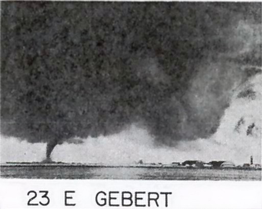
During the late afternoon and evening hours of June 20, 1957, a violent, "long lived" (it was later confirmed that it was a tornado family) and deadly F5 tornado, commonly known as the Fargo tornado, struck the north side of Fargo, North Dakota[2] as well as the area north of Moorhead, Minnesota. It was part of a family of five devastating tornadoes produced by one supercell over the course of 3.5 hours, although they are listed as one continuous tornado. The tornado family started in North Dakota, traveled 27.4 miles (44.1 km) to the Minnesota border before crossing it and continuing for another 25 miles (40 km) for a total track length of 52.4 miles (84.3 km), with the tornado itself travelling 9 miles (14 km).[1][3][4] Additionally, at its widest point, the damage swath reached 500 yards (460 m) across. A total of 12 people were killed, making it the deadliest tornado in North Dakota history. Meanwhile, 103 others were injured, and damage was estimated at $25.25 million (1957 USD). It was part of a larger outbreak sequence of 23 tornadoes that affected the Midwest and Great Plains. It was the most recent tornado in North Dakota to be rated F5/EF5 until the Enderlin tornado exactly 68 years later on June 20, 2025.

Tornado summary

[edit]

The F5 tornado that hit Fargo was the third in the tornado family that moved from Central North Dakota to Central Minnesota, as well as the strongest and most catastrophic. The tornado was sighted as a funnel cloud above Mapleton, North Dakota at 6:25 p.m. on June 20, 1957. It touched down at 7:40 p.m. a mile west of 29th Street North in Fargo and traveled generally northeast for nine miles (14 km), moving directly through the north side of Fargo between 7th Avenue North and 12th Avenue North. It then crossed the Red River into Northeastern Moorhead, Minnesota, before occluding northward and dissipating. It had a peak width of 500 yards (460 m) and was on the ground for 21 minutes. At times, it moved as slowly as 10 miles per hour (16 km/h), contributing to its destructiveness. In addition, the communities of Wheatland, North Dakota, Casselton, North Dakota, Glyndon, Minnesota, and Dale, Minnesota were damaged from F0, F2, F4, and F3 tornadoes, respectively. The F0 and F2 tornadoes occurred before the Fargo F5 tornado, while the F4 and F3 tornadoes occurred afterwards, with all of them happening over a time period of 3.5 hours from 4:40 p.m. to 8:10 p.m. CDT. However, the event is officially listed as one long-tracked F5 tornado.[5][6][7]

Damage was extensive and included 100 blocks of North Fargo. Approximately 329 homes were destroyed and some of them were completely swept off their foundations. An additional 1,035 homes were damaged.[8] The worst residential damage occurred in the Golden Ridge Subdivision (today the Madison Elementary School district) near 25th Street North, much of which was swept away and scattered across a nearby farm field. A total of 15 farm homes were destroyed and 25 others damaged. Four churches and three schools, including Shanley High School, Sacred Heart Academy, and buildings on the North Dakota Agricultural College campus were also severely damaged. It also damaged 15 businesses that were destroyed and 30 others that suffered major damage. These were mainly small local shops. A total of 200 automobiles were destroyed and 300 damaged.[9] Some debris from the F5 tornado was found in Becker County over 50 miles (80 km) east of Fargo.

Casualties

[edit]

Ten people lost their lives in the immediate aftermath of the storm, making it the deadliest tornado in North Dakota history. Two additional individuals later succumbed to injuries likely sustained during the tornado; however, they were not included in the official fatality count. All of the confirmed victims were residents of the Golden Ridge neighborhood, a predominantly working-class area characterized by modest, economically constructed homes, few of which were equipped with basements.[10] An additional 103 people were injured. Because of the tornado's relatively slow speed, many neighborhood residents fled the area in their cars before the storm hit. The victims of the tornado are as follows:

1-2. Donald Titgen, Betty Titgen.

Donald and Betty Titgen, a married couple, lived in a mobile home at the western edge of Golden Ridge. When the tornado struck, Donald was killed instantly; Betty was seriously injured and remained in a coma until her death in January 1960. Their two young daughters, who had been in the care of an aunt that day, were later raised by relatives.[11]

3-5. Theodore Udahl, Teresa Udahl, Mary Jean Udahl.

Two blocks to the east of the Titgens, Theodore and Teresa Udahl and their eight-year-old daughter Mary Jean were killed when their home was impacted by the tornado. In the confusion afterwards, Theodore and Teresa were mistakenly identified as another couple, while Mary Jean, whose body was found almost a block away from where the Udahl home had stood, was not properly identified until the next day.[12]

6. Laura Schoenherr.

Sixty-nine-year-old Laura Schoenherr, who lived in a mobile home one block east of the Udahls, had been trying to take shelter in her daughter's home next door when the tornado struck. She suffered serious injuries which resulted in the amputation of one of her legs, as well as the loss of function in one arm. She died in the hospital approximately three weeks later on July 15.[13]

7-12. The Munson family

The remaining six fatalities came from a single family. In the summer of 1957, Gerald and Mercedes Munson lived at the far eastern edge of Golden Ridge with their seven children; Phyllis, LeRoy, Darwin, Bradley, Jeanette, Lois Ann and Mary Beth, whose ages at the time were 16, 14, 12, 10, 5, 2, and 16 months respectively. On June 20, Gerald was in Bismarck, North Dakota for his job as a truck driver, while Mercedes was also at her job as a bartender. LeRoy was babysitting for a neighbor while Phyllis was at home with the younger children. That day had also been Mercedes' 36th birthday and she had arranged to leave work early to celebrate her birthday with her children. When Mercedes first heard the storm warnings she called home to check on her children. Phyllis answered the phone, yelling for her mother before the call disconnected.[14]

Mercedes quickly caught a ride across town in an effort to reach her children, only to find her neighborhood in ruins. After finding LeRoy unharmed, a neighbor told her to head for a hospital, which she did along with a friend who gave her a ride. As the evening progressed the two women went back and forth between the city's two main hospitals, St. John's and St. Luke's. Before long, she learned the what had happened. Her family's home had been directly in the path of the tornado, and like most homes in the neighborhood, did not have a basement. Phyllis and her five younger siblings had tried to take shelter under a table when the house collapsed upon them. Mercedes first identified Phyllis, Jeanette and Mary Beth in the basement morgue at St. John's hospital, while Lois Ann had been found alive but gravely injured. Meanwhile, at St. Luke's, she identified Bradley in the morgue, and was informed that Darwin had also survived but was also severely injured. Mercedes was not allowed to see either of them. Darwin died from his injuries just before midnight, while Lois Ann died at 2:30 a.m. the following morning.[15] Gerald Munson learned the fate of six of his children the morning after the tornado.[16]

The following morning, news of the deaths of the six Munson children and the disaster made headlines in newspapers across the country. Included in the story of the Munsons was a photograph taken by Fargo Forum photographer Cal Olson, showing 21-year-old Richard Shaw, a neighbor of the Munsons, carrying the body of Jeanette Munson out of the wreckage of their home. The photograph was hailed as symbolizing in raw detail the horror experienced by Fargo in the wake of the tornado, and the following year helped the Forum win a Pulitzer Prize.[17]

Aftermath and recovery

[edit]

The 1957 Fargo tornado has been identified as the deadliest tornado in North Dakota to date.[18]

After 1971, when Ted Fujita introduced his scale that rates tornadoes based on the damage they cause, the Fargo tornado received an F5 rating, the highest level. The Fargo tornado is considered the most devastating in North Dakota history, and was one of only three F5/EF5 tornadoes that have struck the state, the other occurring four years earlier in 1953. In 2025, the third F5/EF5 tornado struck the state near Enderlin. The Fargo area was also hit by F3 tornadoes on June 13, 1950, August 30, 1956, and June 15, 1973, but none of these caused any fatalities. As of 2025, this remains the one of the northernmost F5/EF5 tornadoes in the United States.

An image of the tornado is featured on the cover of the 1984 album Couldn't Stand the Weather by Stevie Ray Vaughan and Double Trouble.

In June 2007, the 50th anniversary of the Fargo tornado was commemorated by the Fargo Forum, which ran a week-long series of stories on the tornado.

In 2010, North Dakota Associate Poet Laureate Jamie Parsley authored a book about the Fargo tornado entitled Fargo, 1957: An Elegy, which was published by the Institute for Regional Studies at North Dakota State University in Fargo.

In 2019, the Cass Act Players performed a musical based on the events of the tornado called "Weather the Storm" at Bonanzaville Museum in West Fargo, ND.[19]

See also

[edit]

Notes

[edit]

References

[edit]
[edit]
Revisions and contributorsEdit on WikipediaRead on Wikipedia
from Grokipedia
The Fargo tornado was a violent F5 that struck Fargo, North Dakota, on the evening of June 20, 1957, killing 10 people and injuring 103 others while causing widespread destruction across the city. The , with estimated winds exceeding 261 miles per hour, carved a 9-mile path through northern Fargo and into neighboring , reaching a maximum width of 700 feet. It leveled or severely damaged over 1,300 homes, along with schools, churches, businesses, and public infrastructure, resulting in property damage estimated at $20 million in 1957 dollars (equivalent to approximately $229 million in 2025 dollars). As the deadliest tornado in history and one of three confirmed F5/EF5 events in the state (previously one of two prior to the 2025 Enderlin tornado), it was spawned by a long-lived that produced a family of five tornadoes over a 70-mile intermittent track. The event's extensive photographic and film documentation enabled groundbreaking post-storm analysis by meteorologist Tetsuya Fujita, whose research helped develop the for tornado intensity rating and introduced concepts like the "wall cloud."

Meteorological context

Synoptic conditions

In mid-June 1957, a persistent upper-level shortwave ridge positioned over at 1200 UTC on June 20 began shifting eastward by 0000 UTC on June 21, facilitating the of rich low-level into the Northern Plains while enhancing mid-level flow aloft. This pattern set the stage for widespread convective activity across the region. A vigorous surface low-pressure system intensified over the northern Plains, deepening to around 994 mb near Fargo and tracking from southwestern at 1200 UTC to central by 1500 UTC. Accompanying this low was a pronounced extending southward from west of , by 1800 UTC, which delineated the warm sector encompassing Fargo and acted as a primary trigger for severe thunderstorms by lifting unstable air parcels. Surface analyses revealed a well-defined extending into the Fargo area, with southerly winds promoting convergence. Dew point temperatures at Fargo climbed from 59°F at 1800 UTC to 69°F by 0000 UTC, with broader surface observations indicating values exceeding 70°F pooled along the , underscoring the abundant low-level moisture available for . was extreme, with surface-based (CAPE) exceeding 3,000 J/kg near Fargo. Veering wind profiles aloft, influenced by a low-level jet evident in rawinsonde data from nearby stations like , yielded 0-6 km bulk shear of 60-70 knots, ideal for organizing rotating updrafts into supercells. These synoptic conditions were integral to the broader June 20–23, 1957, tornado outbreak sequence across the and states, which generated over 20 tornadoes, including the violent Fargo event spawned by a long-lived cyclic .

Local formation

The that generated the Fargo tornado family initiated development around 3:00 p.m. CDT on June 20, 1957, southwest of , amid mesoscale processes driven by the interaction between an advancing and a dryline along the eastern edge of a precipitation area in the warm sector. This promoted strong convective activity through enhanced moisture convergence, with low-level southerly flow beneath a 700-mb moist tongue from to upper contributing to high instability (SBCAPE approximately 3000 J kg⁻¹) and favorable vertical (0-6 km bulk shear of 60-70 kt). As the storm evolved into a long-lived cyclic persisting for at least six hours, a developed within its rotating , characterized by intense vertical motion (up to 80 ft/sec at 3,000 ft) and convergence rates around 3000 × 10⁻⁵ sec⁻¹. Backing surface winds to southeasterly directions, combined with increased low-level shear exceeding 20 kt and storm-relative helicity near 325 m² s⁻², intensified the mesocyclone's rotation, particularly near an that further boosted low-level spin through enhanced moisture and wind backing. Low lifted condensation levels (around 700 m AGL) facilitated the descent of the rotating column to the surface. This rotation culminated in the first touchdown at 4:40 p.m. CDT east of Wheatland, . The parent then produced five successive over more than four hours, featuring a rotating system with wall and tail clouds, and resulting in intermittent damage paths totaling 70 miles across and .

Characteristics and path

Intensity and structure

The Fargo tornado was rated F5 on the original , indicating estimated wind speeds exceeding 261 mph (420 km/h), based on extensive damage analysis that included complete destruction of well-constructed homes and debarking of trees. This rating was retrospectively assigned in 1971 by Tetsuya Theodore Fujita, who conducted detailed post-event surveys using aerial photography, ground damage assessments, and photogrammetric techniques to map the tornado's intensity and path. Under the modern Enhanced Fujita (EF) scale, it would equivalently classify as EF5 due to the extreme structural devastation observed. The exhibited a classic cone-shaped structure that transitioned through developmental stages, including an initial wide base, a rounded bottom phase, and eventual narrowing to a rope-like form during dissipation, as documented through and eyewitness accounts analyzed by Fujita. It formed part of a tornado family produced by a single , featuring multiple satellite tornadoes that cycled in and out of visibility, with at least five distinct members observed across the event. The primary Fargo-impacting vortex reached a maximum path width of 0.5 miles (0.8 km) in the city's western residential suburbs, where convergence rates in the rotating cloud base exceeded 3,000 × 10⁻⁵ s⁻¹, contributing to its destructive power. The overall tornado family persisted for approximately 3.75 hours, from the initial touchdown near Wheatland, , around 5:30 p.m. CDT to final dissipation near Dale, Minnesota, producing an intermittent damage path totaling about 70 miles (110 km). The main vortex affecting Fargo remained on the ground for approximately 1 hour, traversing a continuous path of 9 miles (14 km) at forward speeds as low as 10 mph (16 km/h) in some segments, allowing prolonged exposure to the affected area.

Track details

The Fargo tornado was part of a family of five tornadoes produced by a long-lived that tracked across eastern and western on June 20, 1957. The first touchdown in the family occurred in rural , near Wheatland, around 5:30 p.m. CDT, as the storm progressed eastward through sparsely populated farmland. Intermittent weaker tornadoes followed, with the primary F5 tornado forming approximately 3.5 miles west of Fargo around 7:27 p.m. CDT and rapidly intensifying as it entered the city's north side. The F5 tornado carved a continuous 9-mile path through Fargo, moving generally eastward before turning northeast, with a swath that impacted over 100 city blocks at its peak before exiting the urban area. It crossed the Red River into Minnesota shortly after 8:00 p.m. CDT, continuing through rural areas southeast of Moorhead and producing additional damage before the family dissipated near Dale, Minnesota, around 8:30 p.m. CDT. The overall track of the tornado family spanned approximately 70 miles intermittently, with roughly 27 miles in and the remainder in , making it one of the longest violent tornado families on record for the region. As of 2025, the Fargo F5 remains the northernmost tornado rated F5/EF5 in history, with its touchdown latitude of about 46.9°N surpassing all others.

Impact on Fargo

Structural damage

The 1957 Fargo tornado inflicted severe structural damage across northern residential neighborhoods, particularly in the Golden Ridge area, where modest working-class homes with few basements were devastated. A total of 329 homes were completely destroyed, many swept clean off their foundations in characteristic F5-level destruction, while another 1,035 homes sustained varying degrees of damage across a swath spanning approximately 100 blocks. Infrastructure in the affected zones was extensively disrupted, with numerous power lines downed, roads blocked by debris, and the campus of experiencing light damage to buildings and gates. Examples of the tornado's extreme intensity included vehicles hurled hundreds of yards and trees debarked along the path, underscoring the violent winds exceeding 261 mph that pulverized structures and vegetation. The overall economic impact amounted to $25 million in (1957 USD), equivalent to approximately $288 million in 2025 dollars when adjusted for . This figure encompassed losses to residential properties, public buildings, and , highlighting the tornado's role as one of North Dakota's costliest natural disasters at the time.

Human casualties

The 1957 Fargo tornado claimed 12 lives in total (10 direct fatalities and 2 resulting from injuries), marking it as the deadliest tornado in North Dakota's recorded history. Among the fatalities were six children from the Munson family—ranging in age from 16 months to 16 years—whose home in north Fargo was obliterated by the storm, leaving their mother hospitalized and one sibling as the sole survivor. In addition to the deaths, the tornado injured 103 people, the majority of whom suffered wounds from flying debris and collapses of structures along its path through the city. The toll primarily affected of north Fargo, a developing suburban area at the time, where homes and farms bore the brunt of the F5 tornado's fury. No organized evacuations took place due to the limited warning systems of 1957, which depended on radio alerts and spotter reports rather than widespread sirens or instant notifications, though some individuals fled based on visual cues of the approaching storm.

Immediate aftermath

Emergency response

In the immediate aftermath of the F5 tornado that struck Fargo, North Dakota, on the evening of June 20, 1957, local emergency services sprang into action. The tornado struck around 7:40 p.m. CDT, prompting the rapid mobilization of the Fargo Fire and Police Departments, with all personnel called to duty to manage the chaos in the devastated north side neighborhoods. Firefighters and police, many of whom had lost their own homes, focused on extinguishing fires sparked by downed power lines and conducting initial searches through rubble for survivors. Ambulances from Fargo, , and surrounding communities were dispatched from a central at the police station to transport the injured. The National Guard was activated at the request of Fargo Herschel Lashkowitz shortly after the dissipated, with 300 to 800 guardsmen arriving from Camp Grafton in army trucks to assist with search-and-rescue operations, debris clearance, and securing the affected areas against and unauthorized access. The also mobilized immediately, with members reporting for duty to patrol damaged zones, control crowds of sightseers, and support cleanup efforts through all-night shifts. volunteers joined fire crews in combing through wreckage, while service clubs and veterans' organizations provided additional manpower for body recovery and initial aid distribution at the Main Avenue fire station. Medical facilities in Fargo and nearby Moorhead were quickly overwhelmed as 103 people sustained injuries ranging from cuts and fractures to more severe trauma. St. Luke's Hospital treated 47 patients by 10:30 p.m., utilizing its cafeteria as an impromptu center with mattresses laid out for wound care under emergency generator power, while six remained in critical condition; St. John's Hospital admitted around 35, with 12 requiring overnight stays. All physicians in the Fargo-Moorhead area were summoned for emergency duty via radio alerts, and hospital staff carried patients up stairs due to power outages affecting elevators. The Red Cross coordinated immediate relief, establishing homeless shelters, distributing food, water, clothing, and blankets, and aiding in victim identification at hospitals; these efforts supported approximately 2,000 residents displaced by the destruction of 329 homes. Federal involvement began swiftly, with President declaring Fargo a major disaster area on June 21, 1957, which unlocked access to low-interest loans and other federal assistance for affected residents and businesses. This declaration facilitated coordinated aid from state and national levels, including support for ongoing rescue and recovery in the first 48 hours.

Initial recovery

Following the June 20, 1957, tornado, Fargo initiated rapid rebuilding efforts, prioritizing lightly damaged structures on a basis to restore basic shelter quickly. Of the 329 homes completely destroyed and 1,035 damaged, city officials issued 888 building permits between June 20 and October 27, 1957, totaling $4,281,812 in value, enabling widespread reconstruction and repairs by late fall. Heavy rains followed the tornado, further complicating debris clearance efforts. Insurance claims were processed amid a mix of funding sources, including low-interest loans from the (SBA) and (FHA), following President 's disaster declaration. Community support played a pivotal role in the short-term recovery, with local fundraising drives and volunteer labor accelerating debris clearance and aid distribution. The chapters in Cass and Clay counties disbursed $286,777 in assistance by September 24, 1957, covering essentials like food, blankets, and temporary housing for thousands left homeless. Churches, including Immanuel Lutheran, mobilized to repair their damaged facilities and support congregants, while Mennonite volunteers from arrived with chainsaws and equipment to aid in clearing rubble and reconstructing homes. Additional funds came from international donors, such as Winnipeg's $40,000 contribution on September 14, 1957, and neighbors who sent labor and money. Federal assistance provided an economic boost, supplementing local efforts with targeted recovery funds. On August 26, 1958, the city received $22,787.61 specifically for cleanup and restoration, while the and volunteers from surrounding areas handled initial debris removal under challenging conditions like heavy rains. These resources enabled feeding centers, operated by groups like the Red Cross for six weeks, to serve hot meals to survivors, fostering community resilience during the months-long process. The event also prompted enhancements to local weather spotter networks, strengthening coordination with the as a precursor to formalized protocols for severe storm monitoring.

Long-term legacy

Scientific influence

The 1957 Fargo tornado provided a pivotal for advancing , particularly through the detailed conducted by Tetsuya Fujita. Fujita examined approximately 200 photographs and motion pictures taken by residents, along with eyewitness accounts and ground surveys, to reconstruct the 's lifecycle and damage patterns. This work enabled him to map the presence of multiple vortices within the primary funnel, revealing smaller subvortices responsible for irregular destruction, such as selective scouring in fields and uneven structural impacts. Representing the first comprehensive study of a family—comprising five interrelated vortices produced by a single —this marked a breakthrough in understanding complex structures. Fujita's findings directly influenced the development of the in 1971, which standardized intensity classification based on damage indicators rather than direct wind measurements. The Fargo event's documentation contributed significantly to improvements in tornado forecasting by elucidating thunderstorm dynamics. Fujita's photogrammetric techniques highlighted the role of rotating updrafts and in generating multiple tornadoes, including potential satellite vortices detached from the main funnel, thereby refining models of storm evolution. These insights informed early (NWS) protocols for severe weather prediction, emphasizing the need for detailed storm tracking. The raw data, including photographs, damage surveys, and meteorological observations from the event, were incorporated into NWS and NOAA archives, serving as a foundational resource for subsequent research on tornado genesis and propagation. As of 2025, the Fargo tornado remains a benchmark case for studying F5-level events due to its well-documented intensity and path. Recent numerical simulations have utilized the 1957 observational data to validate models of behavior and formation, aiding in the assessment of environmental factors like and . This historical dataset continues to support broader meteorological validations, including those exploring potential shifts in patterns under changing conditions.

Commemorations and cultural impact

The 50th anniversary of the Fargo tornado in 2007 was marked by a memorial service led by Fargo Mayor Dennis Walaker, which included a slideshow of aftermath photographs and the dedication of a permanent outside City Hall to honor the 12 victims and those affected. Purple ribbons were also placed along the tornado's path on trees and light poles as a visual tribute throughout the city. For the 60th anniversary in 2017, (NDSU) contributed significantly through its archives, providing historical photographs and materials featured in public commemorations and media retrospectives that highlighted survivor accounts and the event's lasting resonance. In 2025, the 68th anniversary prompted remembrances, including media outlets such as local news stations airing retrospectives revisiting the storm's path and personal stories to educate newer generations. In October 2025, as part of its 75th anniversary celebrations, Immanuel Lutheran Church in north Fargo honored the impact of the 1957 tornado during services, reflecting on the roof damage and community rebuilding efforts. Cultural representations of the tornado have emerged in literature and performing arts. In 2010, North Dakota Associate Poet Laureate Jamie Parsley published Fargo, 1957: An Elegy, a poetry collection that meditates on the human and emotional toll of the disaster through elegiac verses drawn from historical accounts and survivor narratives. A 2019 musical titled Weather the Storm, written by local playwright Tracy Frank with music by Topher Williams and produced by Cass Act Players, dramatized the community's resilience in the Golden Ridge neighborhood, premiering at Bonanzaville USA in West Fargo to explore themes of loss and unity. Additionally, a photograph of the tornado appeared on the cover of Stevie Ray Vaughan and Double Trouble's 1984 album Couldn't Stand the Weather, inadvertently embedding the event in broader popular culture. Long-term societal remembrance includes annual educational programs by the (NWS) in Grand Forks, which reference the Fargo tornado in awareness initiatives to teach about tornado safety and historical lessons.

References

Add your contribution
Related Hubs
User Avatar
No comments yet.