Hubbry Logo
Gedeo ZoneGedeo ZoneMain
Open search
Gedeo Zone
Community hub
Gedeo Zone
logo
8 pages, 0 posts
0 subscribers
Be the first to start a discussion here.
Gedeo Zone
Gedeo Zone
from Wikipedia
Map of the regions and zones of Ethiopia

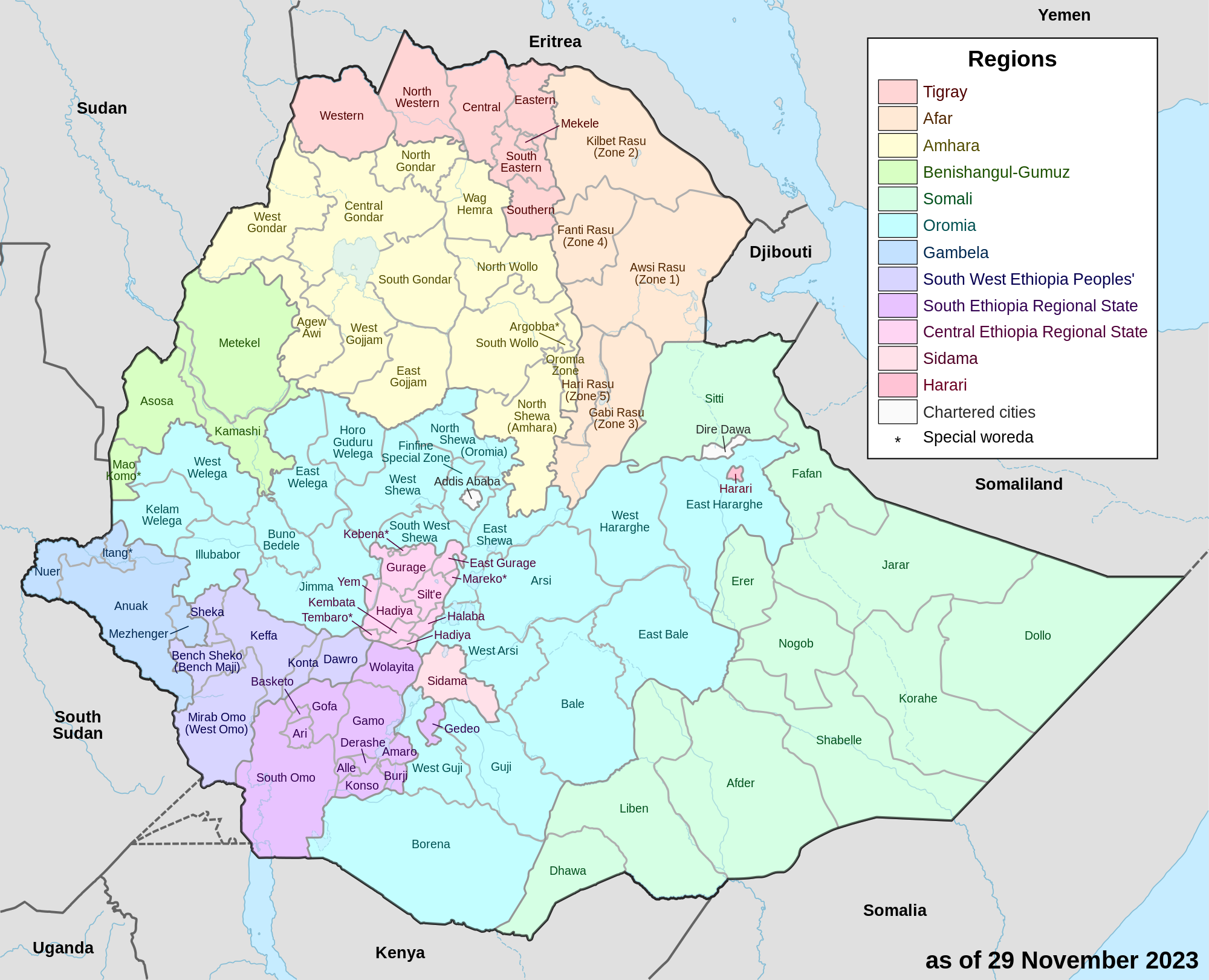
Gedeo is a zone in the South Ethiopia Regional State (SERS) of Ethiopia. This zone is named for the Gedeo people, whose homelands lie in this zone. Gedeo is an exclave of the SERS consisting of a narrow strip of land along the eastern escarpment of the Ethiopian Highlands. It is surrounded by the Oromia Region, which borders the Zone on the east, south and west; Gedeo shares its northern boundary with the Sidama Region. Dilla is the administrative center; other towns include Dilla, Wonago, Yirgachefe, Chelelekitu and Gedeb.

Overview

[edit]

The altitude of the Zone ranges from 1268 meters above sea level in the vicinity of Lake Abaya to an elevation of 2993 meters at Haro Wolabu Pond.[1] Gedeo has 215 kilometers of all-weather roads and 54 kilometers of dry-weather roads, for an average road density of 199 kilometers per 1000 square kilometers.[2]

The Central Statistical Agency (CSA) reported that 63,562 tons of coffee were produced in Sidama and Gedeo combined in the year ending in 2005, based on inspection records from the Ethiopian Coffee and Tea authority. This represented 63% of the Southern Nations, Nationalities and Peoples' Region (SNNPR)'s output and 28% of Ethiopia's total output.[3] On 28 July 2009, the Zonal agriculture and rural development coordination department in Dila reported that over 359.2 million Birr of coffee had been produced by farmers in the Gedeo Zone over the course of the year.[4] Because of the traditional agrofestry practices employed by the Gedeo people and the cultural importance of the landscape, the Gedeo Cultural Landscape was inscribed on the UNESCO World Heritage List in 2023.[5]

Demographics

[edit]

The 2007 Census conducted by the Central Statistical Agency of Ethiopia reports this Zone has a total population of 847,434, of whom 424,742 are men and 422,692 women; with an area of 1,210.89 square kilometers, Gedeo has a population density of 699.84. While 107,781 or 12.72% are urban inhabitants, a further 39 individuals are pastoralists. A total of 179,677 households were counted in this Zone, which results in an average of 4.72 persons to a household, and 172,782 housing units. The four largest ethnic groups reported in this Zone were the Gedeo (86.14%), the Oromo (4.71%), the Amhara (3.37%) and the Gurage (1.55%); all other ethnic groups made up 4.23% of the population. Gedeo is spoken as a first language by 86.82%, 5.82% speak Amharic and 4.12% speak Oromiffa; the remaining 3.24% spoke all other primary languages reported. A majority of the inhabitants said they were Protestants, with 73.21% of the population reporting answers in that category, while 10.67% practiced Ethiopian Orthodox Christianity, 7.96% observed traditional religions, 2.44% were Muslim, and 2.11% embraced Catholicism.[6]

In the 1994 Census, Gedeo had a population of 564,073 in 124,874 households, of whom 282,595 were men and 281,478 women; 65,374 or 11.59% of its population were urban dwellers. The five largest ethnic groups reported in this Zone were the Gedeo (81.21%), the Oromo (8.33%), the Amhara (4.35%), the Sidama (1.15%) and the Silt'e (1.11%); all other ethnic groups made up 3.85% of the population. Gedeuffa is spoken as a first language by 81.45%, 7.79% speak Oromiffa, 7.64% Amharic, and 1.1% speak Sidamo; the remaining 2.02% spoke all other primary languages reported. A plurality of the inhabitants said they were Protestants, with 43.24% of the population reporting answers in that category, while 24.57% observed traditional religions, 22.1% practiced Ethiopian Orthodox Christianity, 2.84% embraced Catholicism, and 2.77% were Muslim.[7]

According to a May 24, 2004 World Bank memorandum, 11% of the inhabitants of Gedeo have access to electricity, this zone has a road density of 231.7 kilometers per 1000 square kilometers (compared to the national average of 30 kilometers),[8] the average rural household has 0.3 hectare of land (compared to the national average of 1.01 hectare of land and an average of 0.89 for the former SNNPR)[9] and the equivalent of 0.2 heads of livestock. 19.6% of the population is in non-farm related jobs, compared to the national average of 25% and a Regional average of 32%. 65% of all eligible children are enrolled in primary school, and 17% in secondary schools. 40% of the zone is exposed to malaria, and 37% to Tsetse fly. The memorandum gave this zone a drought risk rating of 342.[10]

Woredas

[edit]

Woredas of Gedeo Zone are:

  • Chelelekitu Administrative town
  • Gedeb Administrative town
  • Wonago Administrative town

Notes

[edit]
[edit]
Revisions and contributorsEdit on WikipediaRead on Wikipedia
from Grokipedia
The Gedeo Zone is an administrative zone in the South Ethiopia Region of , situated in the southern part of the country along the eastern escarpment of the Main Ethiopian . It encompasses approximately 1,347 square kilometers of diverse terrain, rising from elevations of about 1,450 meters near to over 3,000 meters in the highlands, and is characterized by steep slopes, fertile volcanic soils, and a tropical conducive to . The zone has a population of around 1,247,812 people as of recent estimates, with a high exceeding 900 inhabitants per square kilometer, predominantly comprising the indigenous Gedeo ethnic group who practice traditional and maintain deep cultural ties to the land. Renowned for its sustainable farming systems, the Gedeo Zone's economy is heavily reliant on , with serving as the primary grown in multi-layered indigenous plots that integrate shade trees, enset (a crop), and other perennials to enhance and . These systems span over 38,000 s of cultivation, yielding approximately 24,000 tons of clean annually at a rate of 0.63 tons per , making the zone a key contributor to Ethiopia's global exports. Enset, often called the "tree against hunger," provides for most households, while additional crops like cereals, , and fruits support local subsistence and trade. The zone's cultural landscape, inscribed on the World Heritage List in 2023, exemplifies the Gedeo people's millennia-old traditions of environmental stewardship, including sacred groves protected for spiritual rituals and megalithic monuments that reflect their ancestral heritage. Centered around the town of Dilla, the administrative capital located 377 kilometers south of , the Gedeo Zone faces challenges such as population pressure, climate variability, and occasional inter-ethnic conflicts, yet its resilient agroecological practices continue to sustain livelihoods and preserve in one of Ethiopia's most densely populated rural areas.

Geography

Location and Borders

The Gedeo Zone serves as an exclave within the (SERS), making it a detached portion of the region surrounded primarily by other administrative divisions. It is bordered by the to the north, and by the Region to the east, south, and west. This positioning isolates the zone from the core territories of SERS, highlighting its unique administrative status amid Ethiopia's evolving regional structure. Geographically, the Gedeo Zone lies along the eastern escarpment of the , east of , spanning latitudes from approximately 5°53' N to 6°27' N and longitudes from 38°08' E to 38°30' E. The zone's elevation ranges from about 1,200 meters to 3,000 meters above , encompassing a diverse altitudinal gradient that rises steeply from the rift floor. These coordinates place it in the southern highlands of , within the broader system that influences its physical and ecological characteristics. Covering a total area of 1,347 km², the zone's borders are largely defined by natural features, including the dramatic escarpment and associated river valleys. It is situated approximately 369 km south of , the national capital, facilitating connectivity via major transport routes. Dilla serves as the administrative center of the Gedeo Zone, acting as a key hub for and services. The varied across these borders supports intensive agricultural practices, contributing to the zone's economic vitality.

Topography and Climate

The Gedeo Zone features a predominantly mid-altitude topography, with approximately 71% of its land classified as Woina Dega (midland, ranging from 1,800 to 2,400 meters above sea level), 27% as Dega (highland, 2,400 to 3,200 meters), and 2% as Kola (lowland, below 1,800 meters). This distribution creates a rugged, hilly landscape shaped by the eastern escarpment of the southern Main Ethiopian Rift, with elevations overall spanning 1,500 to 3,000 meters. The soils are primarily fertile volcanic types, including Nitosols and Luvisols derived from Cenozoic volcanic formations, which support dense vegetation cover across the zone. The climate is characteristically cool and highland, with average annual temperatures ranging from 15°C to 25°C, fostering moderate conditions suitable for varied ecological systems. Rainfall follows a bimodal , with the main season (Meher) from to and a shorter Belg from March to May, delivering 1,000 to 2,000 mm annually depending on elevation and microclimatic variations along the Rift Valley . These microclimates arise from the zone's topographic gradients, leading to localized differences in and temperature that influence hydrological patterns. Natural features include extensive forest gardens and enset () plantations, which integrate with the volcanic soils to form resilient vegetated landscapes. The zone's proximity to , along its southern border, affects local hydrology by receiving drainage from rivers like the Gidabo and Gelana, contributing to and seasonal water availability in the rift margin. Environmental challenges encompass risks of , particularly in steeper highland and midland areas where intensive exacerbates during heavy bimodal rains. Volcanic soils, while fertile, are prone to degradation on slopes exceeding 30%, with erosion rates potentially reaching 100-200 tons per annually in vulnerable spots without conservation measures.

History

Origins and Pre-Colonial Period

The are indigenous to the southern highlands of , particularly the region now known as the Gedeo Zone, where they have maintained a distinct rooted in oral traditions. According to these traditions, the Gedeo, formerly referred to as Darasa, trace their origins to a legendary founder named Derasso (or Darasa), who is depicted as the eldest brother among siblings that include Boru, the progenitor of the Borana Oromo, and Urago (or Gujo), the founder of the Guji Oromo. This fraternal linkage underscores a shared ancestral with Oromo groups, positioning the Gedeo as kin within a broader network of in the region, though their language, Gede'uffa, belongs to the Eastern Cushitic branch distinct from Oromo. Pre-colonial Gedeo society developed around sophisticated enset-based systems, which archaeological and ethnobotanical evidence suggests have been practiced for at least 5,000 years in the southwestern , forming the foundation of their forest garden agriculture. Enset (), a perennial crop central to their diet and economy, supported dense populations through its high productivity and integration with multipurpose trees, , and understory crops, enabling sustainable in the humid, rugged terrain. This indigenous innovation not only ensured but also shaped settlement patterns, with homestead gardens evolving into layered agroecosystems that preserved and soil fertility over millennia. Social organization in pre-colonial Gedeo communities was governed by the Songo, a council of elders selected for wisdom and impartiality, which enforced customary laws, resolved disputes, and managed communal resources through consensus-based decision-making. Complementing the Songo was the Ballee system, an indigenous framework of norms and rituals that regulated human-environment interactions, including practices and the protection of sacred groves. These institutions embodied accumulated knowledge for resource stewardship, such as rotational farming and , fostering social cohesion and without centralized authority. Early interactions with neighboring Sidama and Oromo communities were characterized by limited but symbiotic trade and cultural exchanges, driven by complementary economies in the pre-colonial era. Gedeo agricultural surplus, including enset products and early , was traded for Oromo and Sidama crafts along regional routes, while shared rituals and intermarriages reinforced , particularly with the pastoral Guji Oromo, whose qaalluu spiritual leaders facilitated cross-group alliances. These exchanges, though modest in scale, contributed to without significant conflict until external pressures emerged.

Incorporation into Modern Ethiopia

The Gedeo Zone was incorporated into the expanding in 1895 through military conquest under , marking the beginning of centralized control over the region and the imposition of northern Amhara administrative practices. This expansion involved the subjugation of local Gedeo leaders and the allocation of fertile lands to northern settlers known as neftegnas, who were granted estates as rewards for , leading to widespread social disruptions including the displacement of indigenous farmers and the of traditional systems. The northern domination introduced hierarchical governance structures that marginalized Gedeo autonomy, fostering resentment through the enforcement of imperial taxes and labor obligations that conflicted with pre-existing communal customs. During the late 1950s, these grievances culminated in significant resistance movements, particularly the uprisings of 1958–1960, as Gedeo peasants protested against ongoing land alienation and exploitative imperial policies. Northern landlords and officials had intensified land measurements under the qalad system to redistribute holdings to settlers, while imposing the asrat (10% of produce to the state) and erbo (one-fourth of output to landlords), alongside heavy taxation that burdened smallholders without providing commensurate services. The rebellions began with organized refusals to pay dues and petitions to Emperor , escalating to armed clashes led by clan elders (hayitchas) in areas like Michelle and Wonago, resulting in over 200 peasant deaths and property destruction valued at more than 1,000,000 birr. Imperial forces suppressed the uprisings by 1960 through arbitration that redistributed only limited land (500 gashas to peasants) while upholding the erbo and tax systems, fining local leaders and maintaining the status quo until the 1974 revolution. The Italian occupation from 1936 to 1941 briefly altered these dynamics in the Gedeo area, offering locals relative freedom compared to imperial rule by abolishing the erbo system and reducing certain labor demands, though it introduced new and exploitation through forced contributions. This period's policies temporarily halted northern land grabs but ended abruptly with the Allied liberation in 1941, reinstating pre-occupation hardships and exacerbating post-war tensions that fueled later resistances. In the subsequent era (1974–1991), the regime's 1975 proclamation nationalized all rural property, redistributed holdings to peasant associations, and promoted producer cooperatives and villagization programs that reorganized farming into state-directed collectives. Following the fall of the in , the Gedeo area's administrative evolution reflected Ethiopia's shift to , with the region initially integrated into the Southern Nations, Nationalities, and Peoples' Region (SNNPR) established in 1992 under the Transitional Government. The Gedeo Zone was formally created as an administrative unit within SNNPR around the mid-1990s to address ethnic demands, granting it zonal status for local while remaining part of the broader southern regional framework. Recent regional restructurings, including the 2023 referendum that reorganized SNNPR into the (SERS), have positioned the Gedeo Zone as an exclave—a narrow strip along the eastern —surrounded by Region territories, highlighting ongoing boundary adjustments in the federal system. In April 2018, inter-communal violence broke out along the border between the Gedeo Zone and the West Guji Zone of Region, triggered by disputes over administrative boundaries and resource access. The conflict, involving clashes between Gedeo and Guji Oromo communities, escalated rapidly and displaced approximately 958,000 people by mid-2018, marking one of the largest internal displacement crises in at the time; most displacees were ethnic Gedeo seeking refuge within the zone or nearby areas. Government interventions, including security deployments and mediation efforts, facilitated peace agreements by late 2018, enabling the gradual return of over 90% of the displaced population by 2019, though sporadic tensions and recovery challenges persisted.

Demographics

Population and Density

According to the 1994 Population and Housing conducted by Ethiopia's , the Gedeo Zone had a total of 564,073. This figure increased to 847,434 by the 2007 , reflecting an average annual growth rate of approximately 3.2% over the intervening 13 years. Recent estimates indicate a of approximately 1,250,000 as of 2025, driven by sustained high rates and regional migration patterns. The 2007 census reported a population density of 699.84 people per square kilometer across the zone's approximately 1,347 square kilometers, one of the highest in Ethiopia due to its compact highland terrain. Settlement patterns are heavily concentrated in the fertile highland areas, where agricultural productivity supports denser habitation, while lowland regions remain sparsely populated owing to less viable farming conditions. Urbanization in the Gedeo Zone is limited, with over 80% of the residing in rural agrarian settlements as of 2007, a trend that persists amid slow infrastructural development. Dilla, the zone's administrative and commercial hub, is the largest town, with a recorded of 59,150 in 2007 and projected to exceed 150,000 by 2022 based on urban growth models. Population dynamics are influenced by migration, including seasonal inflows of workers from neighboring regions such as Sidama and Gamo Gofa for coffee harvesting, which temporarily boosts labor during peak agricultural periods. This is partially offset by out-migration of youth to urban centers like , primarily driven by limited local employment opportunities beyond farming.

Ethnic Groups, Languages, and Religion

The is predominantly inhabited by the , the indigenous ethnic group for which the zone is named, who constitute 86.14% of the population according to data from the (CSA). Minority ethnic groups include the Oromo at 4.71%, Amhara at 3.37%, Gurage at 1.55%, and smaller populations of Sidama and others comprising the remaining 4.23%. These demographics reflect the zone's location within the diverse South Ethiopia Region (formerly the Southern Nations, Nationalities, and Peoples' Region), where inter-ethnic interactions shape social dynamics. The primary language spoken in the Gedeo Zone is Gedeo (also known as Gedeogna), a Highland East Cushitic language of the Afro-Asiatic family, used as the mother tongue by 86.82% of residents and serving as a core element of local . , the official working language of , is spoken by 5.82%, while Oromiffa (Oromo) accounts for 4.12%, with other languages making up 3.24%. In border areas adjacent to and Sidama regions, is common among Gedeo residents, who often speak Gedeo alongside Oromiffa or Sidama to facilitate , social ties, and daily interactions. Religiously, Protestant dominates, practiced by 74% of the population, a significant increase from 43.24% in the 1994 census, driven by evangelical missions and conversions that reshaped community structures over the intervening decades. Ethiopian Orthodox follows at 10.67%, with traditional indigenous beliefs at 7.96%, at 2.44%, and Catholicism at 2.11%. In rural areas, persists, blending Protestant elements with pre-existing Gedeo spiritual practices tied to ancestral and reverence, particularly among older generations. This integration highlights the adaptive of faith in the zone's agroforestry-dependent communities.

Economy

Agriculture and Agroforestry

The Gedeo Zone's rural economy is predominantly anchored in indigenous systems, characterized by multi-layered forest gardens that integrate trees, perennials, and annual crops on steep, hilly terrains. These home gardens, which cover the majority of the zone's farmland, feature enset (), known as the "false ," as a foundational staple crop that provides through its versatile uses in extraction, fiber, and fodder. Intercropped with enset are grains such as and , vegetables like , fruits, spices, and , creating a diverse, resilient that supports both subsistence and limited cash income. This model, rooted in indigenous and claimed to have evolved from practices over approximately 5,000 years, exemplifies sustainable land use adapted to the region's high of up to 900 persons per square kilometer. Sustainability in these systems is maintained through traditional practices that enhance and , including the strategic arrangement of up to 50 woody from 35 families per 100 square meters, which forms a multi-stratum structure with upper canopy trees, middle-layer enset and shrubs, and lower . is achieved via integrated methods such as organic mulching with leaf litter from native trees like Millettia ferruginea, which promotes rapid decomposition and nutrient recycling, alongside the natural provided by dense root networks and vegetative cover on slopes exceeding 30%. Communal plays a crucial role, with Songo elders—custodians of sacred groves and ritual sites—enforcing traditional rules (seera) to protect totemic trees like africana, ensuring preservation and preventing overexploitation in these culturally significant areas. These practices not only bolster but also sustain livelihoods for smallholder farmers across the zone's altitudinal gradients, from highland enset-dominated plots above 2,300 meters to midland mixtures below that elevation. Despite these strengths, the systems face significant challenges from over-reliance on rain-fed , which exposes crops to variability, including a 15–20% reduction in average rainfall especially between 2007 and 2018 and rising temperatures observed between 1988 and 2018. Such changes have led to increased resource degradation, fluctuating patterns, and threats to key species like enset, exacerbating food insecurity and prompting adaptations such as expanded . pressure and land fragmentation further strain these traditional models, though remains a vital component within the intercropped gardens.

Coffee Production and Trade

The Gedeo Zone plays a pivotal role in Ethiopia's coffee industry, with forming the backbone of its agricultural . In 2005, the Sidama and Gedeo zones combined produced 63,562 tons of , accounting for 63% of the Southern Nations, Nationalities, and Peoples' (SNNPR) output and 28% of the national total, according to inspection records from the Ethiopian and Authority. As of recent estimates (around 2020), the zone yields approximately 24,000 tons of clean annually from 38,000 at a productivity rate of 0.63 tons per . The renowned Yirgacheffe variety, grown extensively in the zone, is celebrated for its distinctive floral and citrus notes, resulting from the region's high-altitude and traditional processing methods. This heirloom contributes significantly to Ethiopia's exports, prized by international roasters for its bright acidity and tea-like body. Prime coffee-growing areas within the zone include the woredas of Yirgacheffe, Kochere, and Gedeb, where cultivation occurs predominantly in shade-grown systems. These systems integrate shrubs with native trees and enset, enhancing and soil health while yielding high-quality beans at elevations of 1,700–2,200 meters above . Such practices, rooted in indigenous Gedeo knowledge, support sustainable production across approximately 38,487 hectares dedicated to . Coffee trade in the Gedeo Zone generates substantial economic value, with farmers earning over 359.2 million Birr from sales in 2009, primarily through cooperatives that facilitate exports to global markets. These cooperatives, such as the Yirgacheffe Coffee Farmers Cooperative Union, handle processing, grading, and shipment, ensuring premium prices for washed and natural lots destined for and . Coffee supports more than 70% of households in the zone as a primary income source, often comprising over 90% of cash earnings for smallholders and driving local development. Post-2010 developments have emphasized , with a surge in and fair-trade initiatives among Gedeo cooperatives. By 2010, all 26 member cooperatives of key unions achieved organic and fair-trade status, enabling access to higher premiums and international buyers committed to ethical sourcing. These efforts, involving 23 primary cooperatives, have bolstered resilience against market volatility while promoting preservation.

Culture and Heritage

Gedeo People and Traditions

The are organized into seven exogamous clans, divided into two moieties known as Sase baxxe (including Hemba’a, Logoda, and Bakkaro) and Shoole baxxe (including Darasha, Gorgorsha, Dobo’a, and Hanuma), which form the basis of their . Political authority within this system is often vested in descendants of the senior wife lineage, emphasizing clan-based hierarchies and community cohesion. Central to governance is the Songo council, a network of over 500 elders across the clans, which serves as a multi-purpose for law-making, , and spiritual guidance. The Songo resolves disputes through indigenous laws called Seera and associated rituals, such as falo (prayers for peace), faci’e (confessions), and qeexala (thanksgiving ceremonies), ensuring social harmony without formal courts. Gedeo traditions revolve around daily and ceremonial practices that integrate , , and community life. The ceremonial coffee ritual, a of , involves green beans over an open fire, grinding them, and brewing in a pot across three rounds—abol (strong), tona (medium), and baraka (light)—often accompanied by and communal conversation, reflecting the zone's role as a origin. Enset (), known as the "tree against hunger," forms the basis of their cuisine, processed by women into kocho, a fermented staple, along with waasa and bu’la dumplings, providing in the highland systems. Oral histories, preserved and narrated by elders during gatherings at songgo (village prayer sites), trace Gedeo origins to the ancient Murgga-Gosallo and emphasize a profound respect for the land as a sentient entity, guiding sustainable practices over millennia. Annual harvest celebrations, such as the Dararo festival marking the Gedeo , bring communities together after the and enset harvest for singing, dancing, and receiving elder blessings, fostering unity and gratitude. Traditional arts include woodworking crafts for household items and tools, while features work songs accompanied by the , a double-headed conical that punctuates communal labor and rituals with rhythmic beats. These living practices underscore the Gedeo cultural identity and contribute to the broader recognition of their . Gender roles among the Gedeo position women as central to labor, particularly in enset harvesting and processing—which requires 5-7 hours per plant—and managing 67% of household reproductive tasks like childcare and cleaning, alongside contributions to (45%) and shoat rearing (42%). Men typically handle land preparation and ploughing, but women bear a heavier overall , averaging 10 hours daily compared to men's 7 hours. Access to for girls is evolving, with increasing enrollment allowing more time for academics amid traditional chores, though barriers like time persist in rural settings.

UNESCO World Heritage Site

The Gedeo Cultural Landscape was inscribed on the World Heritage List in 2023 during the 45th session of the , becoming Africa's 100th inscribed site and Ethiopia's 10th. The property encompasses approximately 29,620 hectares of multilayered systems located along the eastern of the in the Main Ethiopian Rift, primarily within the Wonago and Gedeb woredas of the Gedeo Zone. These landscapes feature intricate, multi-tiered gardens that integrate enset () and cultivation with native trees, sacred forests, and megalithic monuments, all sustained through indigenous knowledge passed down by over 250,000 . The site's international importance lies in its demonstration of sustainable human-environment interactions, where traditional practices optimize limited on steep slopes while preserving and cultural spirituality. It meets criteria (iii) as an exceptional testimony to the living Gedeo cultural tradition of and (v) as an outstanding example of traditional land-use that represents a cultural response to environmental constraints. This recognition highlights the landscape's role in organic coffee production and its broader model for resilient, low-input farming systems. Conservation efforts emphasize community-led management to address threats such as , , and economic pressures that erode traditional practices. Protected under Ethiopia's and local proclamations like No. 189/2021, the site requires strengthened governance to maintain its integrity, with providing technical support for sustainable preservation.

Administration

Woredas and Governance

The Gedeo Zone is administratively divided into six rural woredas—Bule, Dilla Zuria, Gedeb, Kochere, Wenago, and Yirgacheffe—along with Dilla Town as a special administrative unit. Each woreda is further subdivided into kebeles, the smallest units in , which handle grassroots administration and community-level management. These divisions facilitate localized decision-making and service delivery across the zone's approximately 1,347 square kilometers. Governance in the Gedeo Zone operates under the (SERS), established on August 19, 2023, from the former Southern Nations, Nationalities, and Peoples' Region (SNNPR) following constitutional reforms. The zone is led by an elected and administration, with Dilla serving as the administrative center, integrating formal structures with traditional institutions such as the Songo, a of elders that resolves disputes at the neighborhood () level through consensus-based processes. This hybrid approach supports community cohesion while adhering to Ethiopia's federal ethnic-based governance framework. Recent boundary adjustments stem from the 2020 regional reforms, including the creation of the , which isolated Gedeo as an exclave until its incorporation into SERS. Local services emphasize , with zonal health and offices prioritizing programs like the Health Extension Program for preventive care and community outreach in underserved areas, alongside budget allocations that favor and health initiatives to enhance livelihoods.

Infrastructure and Urban Centers

The transportation infrastructure in the Gedeo Zone primarily consists of a road network with 215 kilometers of all-weather roads and 54 kilometers of dry-weather roads (as of 2018), supporting connectivity within the zone and to external regions. Key routes link the administrative capital Dilla to Addis Ababa via the main highway and extend to Yirgacheffe, facilitating access to coffee production and trade hubs in the southern highlands. Urban centers in the zone include Dilla, the capital and a major education hub hosting Dilla University, which serves approximately 30,000 students across various faculties (as of 2024) and contributes to regional development through research and training programs. Yirgacheffe functions as a prominent center for coffee trade, drawing on its location in the heart of highland coffee-growing areas and supporting commerce through cooperatives like the Yirgacheffe Coffee Farmers Cooperative Union. Smaller towns such as Wonago and Gedeb provide local administrative and market services, with Wonago noted for its role in district-level governance and Gedeb as a link between Gedeo and neighboring areas. Utilities in the Gedeo Zone have seen incremental improvements, particularly in water access, which relies on natural springs and boreholes for household and community supply, with geophysical surveys identifying potential zones for further development in areas like Yirgacheffe catchment. Electrification efforts face challenges from aging and frequent outages, though national programs have driven progress, achieving around 55% access across by 2022, with the zone benefiting from grid extensions to urban and peri-urban areas. Telecommunications have expanded since the via Ethio Telecom's rollout of LTE networks to additional cities, enhancing mobile coverage in southern regions including Gedeo to support economic activities like agriculture trade. Despite these developments, rural-urban disparities in service provision remain significant, with rural households often lacking reliable access to and compared to towns like Dilla. Investments in road upgrades, such as the 6-kilometer extension in Yirgacheffe funded by coffee cooperatives, aim to address these gaps by improving trade efficiency and for farmers.

References

Add your contribution
Related Hubs
User Avatar
No comments yet.