

Community hub
Recent from talks
Contribute something
Nothing was collected or created yet.
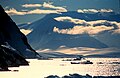
Gerlache Strait
View on Wikipedia
Gerlache Strait or de Gerlache Strait or Détroit de la Belgica is a channel/strait separating the Palmer Archipelago from the Antarctic Peninsula. The Belgian Antarctic Expedition, under Lt. Adrien de Gerlache, explored the strait in January and February 1898, naming it for the expedition ship Belgica.[1] The name was later changed to honor the commander himself.
On the expedition in the Gerlache Strait, biologist Emil Racoviță made several discoveries, including a flightless midge fly that was later (1900) formally named Belgica antarctica by the Belgian entomologist Jean-Charles Jacobs.[1]
The Gerlache Strait has spiky blue icebergs, and is frequented by whales. It can be viewed from Spigot Peak.[2]
Geology
[edit]Four tectonic blocks are identifiable in the Gerlache Strait area, bounded by two systems of Tertiary strike-slip faults. The longitudinal faults include the SW-NE trending Neumayer Fault that extends from Peltier Channel across Wiencke Island, and then onwards most likely as the Gerlache Fault. The SW-NE trending Fournier Fault parallels the Gerlache Fault and divides Anvers Island. The transverse faults trend E-W and SE-NW across Wiencke Island and Brabant Island, and include the Schollaert Channel faults. The Danco Coast Block extends from Cape Willems to Wilhelmina Bay. The Brabant Island Block encompasses the southern portion of that island. The Neumayer Channel Block is bound by the Neumayer Fault and the Fournier Fault. The Anvers-Melchior Islands Block includes northwest Anvers Island and its offshore islands Melchior Islands.[3]
History
[edit]In 1934, polar explorer Lincoln Ellsworth reported in the New York Times that a heavy snowstorm and ice made it necessary to change his plan for going from De Gerlache Strait out to sea and south to Adelaide Island.[4] In 1979, four American adventurers survived a two-month expedition to Antarctica. The Washington Post reported that the most dangerous part of their journey was crossing the Gerlache Straight on a raft.[5]
The writer Dianne Ackerman said she went to Gerlache Strait in the 1990s in order to find inspiration for writing prose.[6]
In 2002, Lynne Cox became the first person to swim a mile in the near-freezing Antarctic Ocean.[7] She did the swim in Gerlache Strait.[7] In 2021, a couple on a ship in the Gerlache Straight captured footage of a gentoo penguin narrowly escaping a few hungry killer whales.[8]
Ecology
[edit]The Gerlache Strait is known to have high abundances of Humpback whale (Megaptera novaengliae) in the austral summer months.[9] Where there are dense swarms on Antarctic krill (Euphausia superba), attracting large aggregations of migrating cetaceans.[10]
Gallery
[edit]-
 Iceberg in the Gerlache
 -
 Iceberg
 -
 Gerlache Strait
 -
 Humpback whales in the strait
 -
 Killer whale swimming

.jpg)

.jpg)
.jpg)
References
[edit]- ^ a b Deckker, Patrick De (2018-01-01). "On the long-ignored scientific achievements of the Belgica expedition 1897–1899". Polar Research. 37 (1) 1474695. doi:10.1080/17518369.2018.1474695. hdl:1885/157188.
- ^ Groer, Annie (23 March 2017). "Checking off my seventh continent: A half-price voyage to Antarctica". Washington Post.
- ^ Birkenmajer, Krzysztof (1999). The Tectonic Structure of Gerlache Strait, West Antarctica, in Polish Polar Studies XXVI Polar Symposium (PDF). Lublin: Polish Polar Studies. pp. 45–50. Retrieved 3 January 2020.
- ^ Ellsworth, Lincoln; Leader; Expedition, Ellsworth Transantarctic Flight (1934-12-03). "ELLSWORTH GAINS WEDDELL SEA ICE; Party Reaches Shelf Surface Only to Find It Dangerous for Plane Take-Off". The New York Times. ISSN 0362-4331. Retrieved 2021-04-10.
SNOW HILL ISLAND, Weddell Sea, Dec. 2. -- A heavy snowstorm and much ice have made it necessary to change the plan for going from De Gerlache Strait out to sea and south to Adelaide Island.
- ^ Krause, Charles (13 April 1979). "To the Bottom of the World". Washington Post.
Having about a week to "kill," they decided to attempt to cross the Gerlache Strait, on which Almirante Brown is located, to some islands several miles away. In some respects, the trip across the straits was the most dangerous part of the journey, since they were forced to travel in choppy seas thay [sic] at any time could have flipped over their light rafts and thrown any or all of them into the freezing water.
- ^ Ackerman, Diane (1999). "Deep Play". archive.nytimes.com. Retrieved 2021-04-10.
- ^ a b Sanders, Erica (2004-01-25). "Just Add Water". The New York Times. ISSN 0362-4331. Retrieved 2021-04-10.
The swim itself, made in the Gerlache Strait to the beach at Neko Harbor, was not without drama.
- ^ Sparks, Hannah (2021-03-08). "Fleeing penguin escapes killer whales in nail-biting video". New York Post. Retrieved 2021-04-10.
Matt Karsten, 40, and his wife Anna, 32, have captured harrowing footage of a gentoo penguin narrowly escaping the jaws of a few hungry killer whales in the Antarctic. The Karstens were whale watching aboard a dinghy in the Gerlache Strait, near the tip of Antarctica, when they spotted a penguin hurry by their vessel — followed by a pod of killer whales just behind.
- ^ Johannessen, John Elling Deehr; Biuw, Martin; Lindstrøm, Ulf; Ollus, Victoria Marja Sofia; Martín López, Lucía Martina; Gkikopoulou, Kalliopi C.; Oosthuizen, Wessel Chris; Lowther, Andrew (2022). "Intra-season variations in distribution and abundance of humpback whales in the West Antarctic Peninsula using cruise vessels as opportunistic platforms". Ecology and Evolution. 12 (2) e8571. Bibcode:2022EcoEv..12E8571J. doi:10.1002/ece3.8571. ISSN 2045-7758. PMC 8826076. PMID 35154653.
- ^ Nowacek, Douglas P.; Friedlaender, Ari S.; Halpin, Patrick N.; Hazen, Elliott L.; Johnston, David W.; Read, Andrew J.; Espinasse, Boris; Zhou, Meng; Zhu, Yiwu (2011-04-27). "Super-Aggregations of Krill and Humpback Whales in Wilhelmina Bay, Antarctic Peninsula". PLOS ONE. 6 (4) e19173. Bibcode:2011PLoSO...619173N. doi:10.1371/journal.pone.0019173. ISSN 1932-6203. PMC 3083408. PMID 21556153.
External links
[edit]64°30′S 62°20′W / 64.500°S 62.333°W
This article needs additional or more specific categories. (September 2024) |