.jpg/2000px-Inkerman_33_(8709967741).jpg)
Community hub
Inkerman
View on Wikipedia
Inkerman (Russian: Инкерман; Ukrainian: Інкерман; Crimean Tatar: İnkerman) is a city in the Crimean peninsula. It is de jure located within the Autonomous Republic of Crimea of Ukraine, but de facto within the federal city of Sevastopol, which is administered as part of the Russian Federation. It lies 5 kilometres (3 miles) east of Sevastopol, at the mouth of the Chernaya River which flows into Sevastopol Inlet (also called the North Inlet). Administratively, Inkerman was subordinate to the municipality of Sevastopol, but since September 2023 it de jure became a part of Bakhchysarai Raion of AR Crimea.[1] The city's population is 10,348 (2014 Census).[2]
Key Information
.jpg)


.jpg)
The name Inkerman is said to mean 'cave fortress' in Turkish.[3] During the Soviet era, the area was known between 1976 and 1991 as Bilokamiansk (Ukrainian: Білокам'янськ) or Belokamensk (Russian: Белокаменск), which literally means 'white stone city', in reference to the soft white stone quarried in the area and commonly used for construction. In 1991 the Ukrainian authorities restored the pre-1976 name.
History
[edit]The area has been inhabited since ancient times. The cave monastery of St. Clement was founded near Inkerman in the 8th century by Byzantine icon-venerators fleeing persecution in their homeland. The monastery was closed during the Soviet era and several of its churches destroyed but is now in restoration and brought back into use.
The city was called Kalamita (Greek: Καλαμίτα) and was a medieval fortress built in the 8th-9th century on a strategic cliff overlooking the estuary and later expanded in the 14th century. In 1475 Kalamita, along with the rest of the Principality of Theodoro, was taken by the Turks, and Kalamita would be renamed Inkerman. After the Treaty of Küçük Kaynarca in 1774 the fortress was abandoned and fell into ruin, but a small settlement at the base of the cliff remained.
Martin Bronevski who visited Inkerman in 1578 saw several Greek inscriptions.[4]
The town became the centre of worldwide attention in 1854 during the Crimean War, when Inkerman was the scene of the Battle of Inkerman and the Battle of Chernaya River, both victorious for the French and the British troops.
During the Soviet times, a large underground ammunition warehouse of the Black Sea Fleet was situated under rocky cliffs in the Inkerman area. The storage was abandoned in the 1970s after an explosion that damaged the facility but did not detonate all its stockpiles. However, no efforts to secure the site were made until the 1990s when local residents began salvaging explosives which led to a number of deaths. Ukrainian Army engineer corps started extracting and decommissioning outdated ammunition in 2000 under a special government program.
Inkerman has since largely returned to its pre-war obscurity, serving as a suburb of Sevastopol linked to the downtown core by commuter ferries. One of the major Crimean wineries featuring the Inkerman label is located in the adjacent area. A popular hiking trail leading into Crimean Mountains begins just east of the town.
A horse in the Household Cavalry Blues and Royals has been named after the town and battle.
The left flank company of the 1st Battalion Grenadier Guards, which holds the traditions of the disbanded 3rd Battalion (which played a large part of the battle) is named after the town and battle. Now known as the Inkerman Company, or by its nickname "The Ribs".
Demographics
[edit]As of the 2001 Ukrainian census, Inkerman had a population of 10,456 inhabitants. The majority of the population are ethnic Russians, followed by a large Ukrainian minority, as well as smaller Belarusian and Crimean Tatar communities. Linguistically, the population is overwhelingly Russophone, while a share of native Ukrainian speakers just exceeds 5%. The exact ethnic and linguistic composition was as follows:[5][6]
Gallery
[edit]-
 View of Inkerman Fortress in 1796, M. M. Ivanov
 -
 Inkerman around 1830
 -
 Inkerman Cave Monastery around 1910
 -
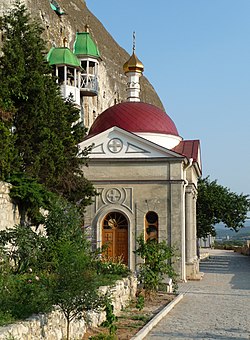 Inkerman orthodox men's cave monastery of St. Clement in 2009

_1.309_INKERMANN.jpg)


See also
[edit]References
[edit]- ^ "Про внесення змін до деяких законодавчих актів України щодо вирішення окремих питань адміністративно-територіального устрою Автономної Республіки Крим". Офіційний вебпортал парламенту України (in Ukrainian). 23 August 2023. Retrieved 28 March 2024.
- ^ Russian Federal State Statistics Service (2014). "Таблица 1.3. Численность населения Крымского федерального округа, городских округов, муниципальных районов, городских и сельских поселений" [Table 1.3. Population of Crimean Federal District, Its Urban Okrugs, Municipal Districts, Urban and Rural Settlements]. Федеральное статистическое наблюдение «Перепись населения в Крымском федеральном округе». ("Population Census in Crimean Federal District" Federal Statistical Examination) (in Russian). Federal State Statistics Service. Retrieved 4 January 2016.
- ^ Compare: Turkish in 'cave, burrow'; Turkish kermen 'fortress'.
- ^ (aka Broniovius, aka Marcin Broniowski, 1568-1624), in his Tartariae Descriptio, according to Alexander A. Vasiliev, The Goths in the Crimea, 1936, p.216
- ^ "Рідні мови в об'єднаних територіальних громадах України". socialdata.org.ua.
- ^ "Національний склад міст".
External links
[edit]- (in English, Russian, and Ukrainian) Official Sevastopol city website
- (in Russian) Inkerman
- (in Russian) Panoramas of Inkerman
| International | |
|---|---|
| National | |
| Other | |
Inkerman
View on GrokipediaGeography
Location and terrain
Inkerman lies approximately 5 kilometers east of Sevastopol in the southwestern part of the Crimean Peninsula, positioned at the mouth of the Chernaya River as it discharges into the northern inlet of Sevastopol Bay.[7][8] The settlement's coordinates place it at roughly 44°37′N 33°49′E, within a region characterized by its proximity to the Black Sea coast and the transitional terrain between the Crimean Mountains and the coastal plain.[9] The terrain of Inkerman is defined by the narrow Inkerman Valley, hemmed in by abrupt limestone cliffs rising sharply from the riverbanks, which create a dramatic, enclosed landscape conducive to natural cave formation.[10][11] These cliffs, part of the broader plateau formations in the area, exhibit karst features including numerous interconnected caves and hollows eroded into the rock faces over geological timescales.[4] The valley floor, following the river's course, gradually widens near the bay, blending low-lying alluvial deposits with elevated rocky outcrops that dominate the eastern approaches to Sevastopol.[12] Geologically, the area consists primarily of Eocene-age oolitic and bryozoan limestones, forming the distinctive white rock layers exposed in the cliffs and quarried historically as "Inkerman stone" for its durability and fine grain.[13][14] These formations result from ancient marine depositional environments, contributing to the region's structural integrity and the prevalence of cliffside cavities.[15] The limestone's softness in certain strata has facilitated natural erosion, while harder layers provide stable overhangs, shaping the rugged topography that distinguishes Inkerman from surrounding coastal flats.[16]Climate
Inkerman experiences a humid subtropical climate (Köppen classification Cfa), featuring mild winters, warm to hot summers, and moderate precipitation concentrated in the cooler months, consistent with the Black Sea coastal zone of the Crimean Peninsula.[17][18] Average annual temperatures hover around 13 °C (55 °F), with July and August peaks of 24–28 °C (75–82 °F) during the day and January lows of about 4 °C (39 °F), rarely dropping below freezing due to maritime influences.[19][17] Precipitation totals approximately 300–400 mm per year, with 60–70% occurring from October to March in the form of rain, while summers remain predominantly dry with infrequent thunderstorms.[20][17] These conditions support local economic activities: the extended dry season minimizes disruptions to quarrying operations in the limestone-rich terrain, and the mild winters combined with ample summer warmth enable viticulture, a key agricultural sector yielding grape varieties suited to the region's 2,000+ annual sunshine hours.[17] Autumnal fog, prevalent in November due to temperature inversions over the Chorna River valley, enhances humidity but can limit visibility, historically impacting navigation and military maneuvers in the area.[17] Recent data indicate stable patterns with no significant deviations from long-term averages, though broader Crimean trends show slight warming of 0.5–1 °C per decade, potentially stressing water resources for agriculture amid dry summers.[19][21]History
Ancient origins and medieval development
The karst cave systems and elevated terrain along the Chorna River valley in Inkerman provided natural defensibility and shelter, enabling human occupation from the Late Paleolithic era, as evidenced by stratified archaeological layers in excavated grottoes revealing tools, hearths, and faunal remains indicative of prolonged habitation.[22] This continuity persisted into the Bronze-Iron Age transition circa 1000 BCE, where settlements in the valley supported cereal agriculture, with findings of storage pits, grinding tools, and carbonized grains demonstrating systematic cultivation of emmer wheat, barley, and millet adapted to the local microclimate and soil.[23] The toponym "Inkerman" originates from Crimean Tatar İnkerman, translating to "cave fortress," a designation reflecting the site's inherent strategic value for defense and resource exploitation, as the caves offered protection from weather, predators, and raiders while facilitating control over river access and quarrying of soft limestone.[10] Ancient Greek influence is attested by inscriptions observed in 1578 by Polish diplomat Martin Bronevski during his travels through the region, which he linked to remnants of Hellenic settlements proximate to the Chersonesos colony established in the 5th century BCE, suggesting episodic use by Greek traders or colonists for maritime oversight.[24] By the 6th century CE, Byzantine authorities fortified the plateau atop Monastyrskaya Skala as the Kalamita outpost, garrisoning it with local populations to secure the southwestern Crimean frontier against barbarian incursions, leveraging the cliffs' sheer drops and cave networks for surveillance and refuge.[2] These cave complexes evolved into early Orthodox monastic enclaves by the early medieval period, serving as ascetic retreats amid recurrent threats from steppe nomads, with rock-hewn chapels and cells embodying a resilient tradition of eremitic Christianity that endured Tatar raids in the 13th-14th centuries and Ottoman conquest in 1475, after which the site retained its fortified nomenclature under Muslim rule.[2][10]Crimean War: Battle of Inkerman
The Battle of Inkerman occurred on 5 November 1854, when Russian forces under General Pyotr Dannenberg launched a surprise dawn attack against British and French positions on the Inkerman Heights, east of Sevastopol, aiming to disrupt the Allied siege lines.[6][25] Dense fog limited visibility to 40 yards, reducing the effectiveness of Allied artillery and forcing reliance on infantry bayonet charges in close-quarters combat, earning the engagement the moniker "Soldiers' Battle."[6] Russian troops, initially numbering around 33,000 with reinforcements bringing totals to over 40,000, advanced in dense columns up the ravines toward Shell Hill and Home Hill, initially overwhelming isolated British units like the 20th Regiment and 77th Regiment.[6][5] Allied defenders, totaling about 12,000 British and 7,000 French troops at the outset, with further reinforcements arriving piecemeal, held through tenacious counterattacks by the Guards Brigade and French divisions under General Pierre Bosquet.[6] British commander Lord Raglan directed ad hoc responses amid communication breakdowns, while French artillery and infantry stabilized the flanks after initial British setbacks, including the near-collapse of the Second Division.[26] By midday, as fog lifted, Allied naval gunfire and concentrated rifle volleys repulsed Russian assaults, forcing a withdrawal; the Russians failed to sever the Allied supply lines or relieve Sevastopol.[6] Casualties reflected the battle's ferocity and imbalance in numbers:| Side | Killed | Wounded | Total |
|---|---|---|---|
| British | 597 | 1,860 | 2,357 |
| French | 143 | 786 | 929 |
| Russian | ~3,000 | ~8,000 | 10,000–12,000 |