Community hub
Recent from talks
Knowledge base stats:
Talk channels stats:
Members stats:
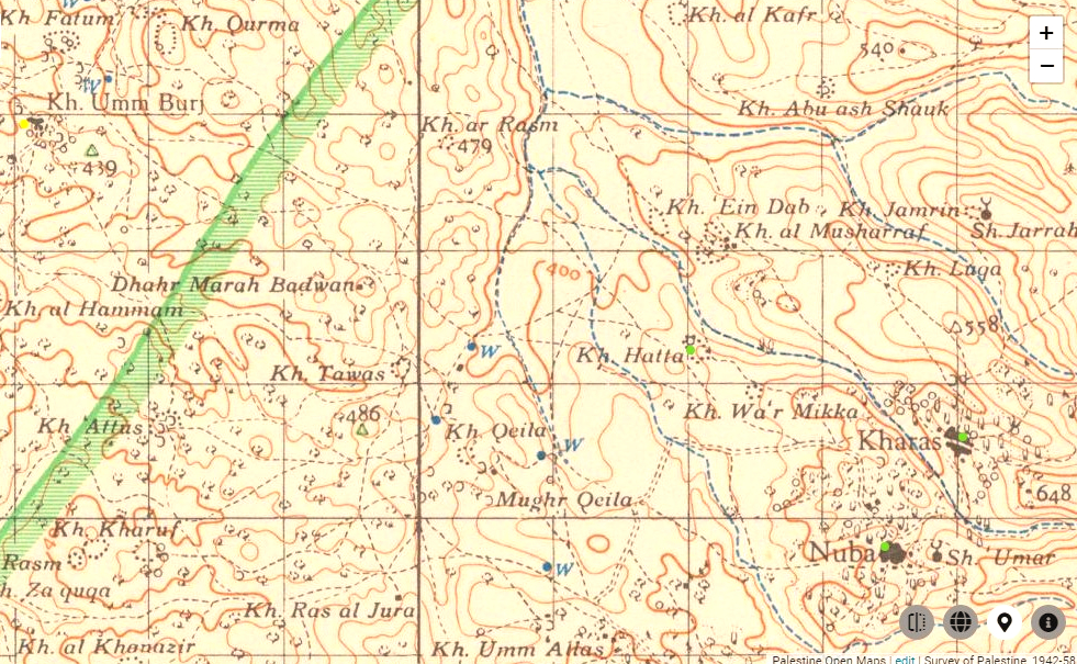
Keilah
Keilah (Hebrew: קְעִילָה, romanized: Qəʿilā, lit. 'Citadel') was a city in the lowlands of the Kingdom of Judah. It is now a ruin known as Khirbet Qeyla near the modern village of Qila, Hebron, 7 miles (11 km) east of Bayt Jibrin and about 3 kilometres (1.9 mi) west of Kharas.
The earliest historical record of Keilah is found in the Amarna letters from the 14th century BCE. In some of them, Qeilah and her king Shuwardatha are mentioned. It is possible to infer from them the importance of this city among the cities of Canaan that bordered near Egypt before the conquest of Canaan by the Israelites.
According to the Hebrew Bible in the First Book of Samuel, the Philistines had made an inroad eastward as far as Keilah and had begun to appropriate the country for themselves by plundering its granaries until David prevented them. Later, upon inquiry, he learnt that the inhabitants of the town, his native countrymen, would prove unfaithful to him, in that they would deliver him up to King Saul, at which time he and his 600 men "departed from Keilah, and went whithersoever they could go”. They fled to the woods at Ziph. "And David was in the wilderness of Ziph, in a wood" (1 Samuel 23:15). Here his friend Jonathan sought him out "and strengthened his hand in God": this was the last meeting between David and Jonathan.
Keilah is mentioned in the Book of Joshua (15:44) as one of the cities of the Shephelah "Lowland". Benjamin of Tudela identified Qaqun as ancient Keilah in 1160. Conder and Kitchener, however, identified the biblical site with Khirbet Qeyla "seven English-miles from Bayt Jibrin" and 11 km (7 mi) northwest of Hebron. The site was earlier described by Eusebius in his Onomasticon as being "[nearly] eight milestones east of Eleutheropolis [now Bayt Jibrin], on the road to Hebron." Victor Guérin, who visited Palestine between the years 1852–1888, also identified Keilah with the same ruin, Khirbet Kila (Arabic: خربة كيلا), near the modern village by that name, a place situated a few kilometres south of Adullam (Khurbet esh Sheikh Madhkur) and west of Kharas. This view has been adopted by the Israel Antiquities Authority. Khirbet Qeyla, lies on the north side of the village of Qila. Guérin found here a subterranean and circular vault, apparently ancient; the vestiges of a wall surrounding the plateau, and on the side of a neighboring hill, tombs cut in the rock face. The town is mentioned in the Amarna letters as Qilta.
Keilah is mentioned in the Book of Nehemiah as one of the towns resettled by the Jewish exiles returning from the Babylonian captivity and who helped to construct the walls of Jerusalem during the reign of the Persian king Artaxerxes I. Nehemiah further records that those returnees were the very descendants of the people who had formerly resided in the town before their banishment from the country, who had all returned to live in their former places of residence.
During the Second Temple period, fig-cake shaped into round or square-shaped hard cakes (Hebrew: דְּבֵילָה, romanized: dəḇilā) were produced in Qeyla, and because of their outstanding and succulent quality and sweetness were permitted to be offered as such in the Temple in Jerusalem as first-fruits, a thing customarily reserved only for fresh fruits (when brought from places near Jerusalem), and for raisins and dried figs when brought from distant places. This is mentioned in the Jerusalem Talmud in the tractate Bikkurim 3:3, and Solomon Sirilio's commentary there.
The town's present residents are Bedouins expelled during 1948 Arab–Israeli War from areas around Beersheba.
Khirbet Qeila (Ruin of Keilah) is situated on a terraced, dome-shaped hill at the end of a spur that descends to the east, adjacent to a small Arab village which bears the same name. On the other side, it is surrounded by channels, which descend into the watercourse of Wadi es-Sur (an extension of the Elah Valley) and fortify it with a natural fortification. Its area is about 50 dunams (12.3 acres). Remains of walls can be seen on its slopes, and in the north is seen the ascent to the city gate, which is made like a ramp with a retaining wall. At the foot of the tell, on the side of the road, burial caves were hewn. The pottery finds at the tell indicate that it had an almost continuous settlement from the Bronze Age to the Crusader and Mamluk periods.
Hub AI
Keilah AI simulator
(@Keilah_simulator)
Keilah
Keilah (Hebrew: קְעִילָה, romanized: Qəʿilā, lit. 'Citadel') was a city in the lowlands of the Kingdom of Judah. It is now a ruin known as Khirbet Qeyla near the modern village of Qila, Hebron, 7 miles (11 km) east of Bayt Jibrin and about 3 kilometres (1.9 mi) west of Kharas.
The earliest historical record of Keilah is found in the Amarna letters from the 14th century BCE. In some of them, Qeilah and her king Shuwardatha are mentioned. It is possible to infer from them the importance of this city among the cities of Canaan that bordered near Egypt before the conquest of Canaan by the Israelites.
According to the Hebrew Bible in the First Book of Samuel, the Philistines had made an inroad eastward as far as Keilah and had begun to appropriate the country for themselves by plundering its granaries until David prevented them. Later, upon inquiry, he learnt that the inhabitants of the town, his native countrymen, would prove unfaithful to him, in that they would deliver him up to King Saul, at which time he and his 600 men "departed from Keilah, and went whithersoever they could go”. They fled to the woods at Ziph. "And David was in the wilderness of Ziph, in a wood" (1 Samuel 23:15). Here his friend Jonathan sought him out "and strengthened his hand in God": this was the last meeting between David and Jonathan.
Keilah is mentioned in the Book of Joshua (15:44) as one of the cities of the Shephelah "Lowland". Benjamin of Tudela identified Qaqun as ancient Keilah in 1160. Conder and Kitchener, however, identified the biblical site with Khirbet Qeyla "seven English-miles from Bayt Jibrin" and 11 km (7 mi) northwest of Hebron. The site was earlier described by Eusebius in his Onomasticon as being "[nearly] eight milestones east of Eleutheropolis [now Bayt Jibrin], on the road to Hebron." Victor Guérin, who visited Palestine between the years 1852–1888, also identified Keilah with the same ruin, Khirbet Kila (Arabic: خربة كيلا), near the modern village by that name, a place situated a few kilometres south of Adullam (Khurbet esh Sheikh Madhkur) and west of Kharas. This view has been adopted by the Israel Antiquities Authority. Khirbet Qeyla, lies on the north side of the village of Qila. Guérin found here a subterranean and circular vault, apparently ancient; the vestiges of a wall surrounding the plateau, and on the side of a neighboring hill, tombs cut in the rock face. The town is mentioned in the Amarna letters as Qilta.
Keilah is mentioned in the Book of Nehemiah as one of the towns resettled by the Jewish exiles returning from the Babylonian captivity and who helped to construct the walls of Jerusalem during the reign of the Persian king Artaxerxes I. Nehemiah further records that those returnees were the very descendants of the people who had formerly resided in the town before their banishment from the country, who had all returned to live in their former places of residence.
During the Second Temple period, fig-cake shaped into round or square-shaped hard cakes (Hebrew: דְּבֵילָה, romanized: dəḇilā) were produced in Qeyla, and because of their outstanding and succulent quality and sweetness were permitted to be offered as such in the Temple in Jerusalem as first-fruits, a thing customarily reserved only for fresh fruits (when brought from places near Jerusalem), and for raisins and dried figs when brought from distant places. This is mentioned in the Jerusalem Talmud in the tractate Bikkurim 3:3, and Solomon Sirilio's commentary there.
The town's present residents are Bedouins expelled during 1948 Arab–Israeli War from areas around Beersheba.
Khirbet Qeila (Ruin of Keilah) is situated on a terraced, dome-shaped hill at the end of a spur that descends to the east, adjacent to a small Arab village which bears the same name. On the other side, it is surrounded by channels, which descend into the watercourse of Wadi es-Sur (an extension of the Elah Valley) and fortify it with a natural fortification. Its area is about 50 dunams (12.3 acres). Remains of walls can be seen on its slopes, and in the north is seen the ascent to the city gate, which is made like a ramp with a retaining wall. At the foot of the tell, on the side of the road, burial caves were hewn. The pottery finds at the tell indicate that it had an almost continuous settlement from the Bronze Age to the Crusader and Mamluk periods.