

Community hub
Recent from talks
Contribute something
Nothing was collected or created yet.
Kothaligad
View on Wikipedia
Kothaligad (also called Kotligad/ Kothligad/Peth) is a small fort (3100 ft) situated to the east of Karjat near Karjat-Murbad Road in the Indian state of Maharashtra. It is a famous trek in the Karjat area, because of its small height and easy climbing. It is also known as the Fort of Peth because of its vicinity to Peth village at its base.
Key Information


How to Reach -
Nearest station is Karjat from there
Karjat railway station - Karjat bus depot - catch bus for Ambivali village ( bus name - solangaon Or Jamrug) - reach the top
Also private vehicle are also available (auto Or tum tum) with around 400-600 rupees
Features
[edit]There is a small temple and large cave at the base and a chimney like tunnel to the top of the fort. This pinnacle is carved from inside forming a staircase reaching the top. There is a tank of water (rock cut water cistern) at some distance from the cave and another one at the top of the fort.[1] The stone is a single black expanse reaching till the Peth village standing on the fertile soil with abundant natural resources for water and farming.
History
[edit]The cave and the temple carvings date back to the 13th century. Not much is known about the history until the 18th century. In 1684 Aurangjeb sent Abdul Kadir and Alai Biradkar to capture this fort. After a small skirmish, the fort was captured by Abdul Kadir. Aurangjeb honoured Abdul Kadir and renamed this fort as Miftah-ul-Fateh (Key to success). Many attempts were made later to win this fort by the Maratha Army, but they were not successful. In 1716, this cave was captured by the British. On 2 November 1817, it was recaptured by the Marathas under the leadership of Bapurao who was general of Bajirao Peshwa. The fort was recaptured by the British on 30 December 1817, by Captain Brooks. The British had the fort till 1862 as an outpost for vigilance on the surrounding valley and the hills all around it.
The locals say that this is not actually a fort but a sort of lighthouse from where the directions were given to know the advancements of the enemy. In fact, it can be called a watch tower to keep a vigil on the Mawal area in the greater province of the Maratha.
Image gallery
[edit]-
 The steep steps of the chimney-like top of the fort are intact and are used by trekkers today.
 -
 Cannons of Kothaligad fort
 -
 Kothaligad
 -
 Carvings on the walls of Kothaligad fort
 -
 Main Entrance, Kothaligad Fort
 -
 Caves Near the Kothaligad Fort
 -
 The distinctive chimney-like feature of Kotligad fort
 -
 Sculpture on the Pillars


See also
[edit]References
[edit]- ^ "The Gazetteers Department - KOLABA". Archived from the original on 1 September 2016. Retrieved 19 July 2017.
External links
[edit]- Click here [1] to see its photosphere of the peak of the Kothaligad fort.
| Chhatrapatis (Kings) | |
|---|---|
| Peshwas (Prime ministers) | |
| Amatya & Pratinidhi (Councilors and viceroys) | |
| Women | |
| Maratha Empire | |
| Battles |
|
| Wars | |
| Adversaries | |
| Forts | |
| Coins | |
Kothaligad
View on GrokipediaLocation and Geography
Site Description and Coordinates
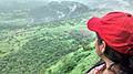
Kothaligad, also known as Peth Fort, is a small hill fort located approximately 21 km northeast of Karjat near the Karjat-Murbad Road in Maharashtra, India.[6] The site lies within the Sahyadri range of the Western Ghats, rising to an elevation of 945 meters (3,100 ft) above sea level.[7] Its geographic coordinates are 18°59′32″N 73°30′45″E.[1] The fort's summit features a prominent tapering, chimney-like pinnacle that dominates the local topography, providing expansive views of the surrounding forested hills and valleys.[2] The base is accessible from Peth village, situated in a rural area amid the Bhimashankar Wildlife Sanctuary region.[1] This isolated, steep-sided hill formation underscores the fort's strategic placement for observation and defense in the rugged terrain.[8]Terrain and Environmental Context
Kothaligad rises as a prominent pinnacle in the Sahyadri range of the Western Ghats, a UNESCO World Heritage site, reaching an elevation of approximately 945 meters (3,100 feet) above sea level. The terrain consists of steep, rocky slopes formed by basaltic rock typical of the Deccan Trap volcanics underlying the region, creating a rugged landscape with sharp ascents and narrow ridges. From base villages such as Ambivli or Peth, trekkers encounter an elevation gain of about 500 meters over a distance of roughly 11 kilometers round trip, featuring undulating paths that transition to sheer chimney-like climbs at the summit.[2][5][1] The surrounding environment is dominated by southern tropical moist deciduous forests, where teak constitutes a key species amid a mix of dry deciduous and semi-evergreen vegetation in the hilly tracts of Raigad district. This forest cover supports regional biodiversity, with the fort's proximity to the Bhimashankar Wildlife Sanctuary enhancing ecological connectivity for fauna such as leopards and various bird species. Lush greenery and seasonal waterfalls emerge prominently during the monsoon (June–September), when annual rainfall exceeds 2,000 millimeters, though the wet, slippery basalt surfaces heighten erosion risks and trekking hazards.[9] Post-monsoon and winter periods (October–May) reveal sparser vegetation and drier conditions, facilitating easier access but exposing the terrain's vulnerability to human foot traffic, which can accelerate soil degradation in this ecologically sensitive zone. The strategic topography historically aided surveillance, offering unobstructed vistas of adjacent peaks like Padargad and the Matheran plateau, while underscoring the site's integration into the Western Ghats' dynamic geomorphic processes.[1][8][2]