

Community hub
Recent from talks
Contribute something
Nothing was collected or created yet.
Pantabangan
View on WikipediaPantabangan, officially the Municipality of Pantabangan, is a municipality in the province of Nueva Ecija, Philippines. According to the 2020 census, it has a population of 31,763 people.[5]
Key Information


.svg)
History
[edit]Pantabangan was founded on November 30, 1645, by Fr. Juan Alonzo de Abarca, an Augustinian priest with the 29th Spanish mission in the Philippines. The village grew into a settlement and was officially included in the map of the Philippines in 1747. In 1900, Pantabangan formally became a town.
In the early 16th and 17th centuries, the “Id-dules” (Aetas or Baluga) and Egongots (Ilongots) tribes inhabited the southern Sierra Madre and Caraballo Mountains. Pantabangan (Pantabanganan in early 18th century) may have come from the root Ilongot word "Sabangan or Sabanganan" that means "junction of water streams". It was learned that most of the places in the area were derived from Ilongot words like Caanaoan, Puncan, Cadanglaan (now Carranglan), Kabaritan (Now San Jose City) and others. Bungamong (Bongabon) and Cadanglaan were formerly sitio of Pantabangan and Kabaritan also part of Pantabangan.
When the Second World War broke out, imperial Japanese forces occupied Pantabangan in 1942. During the Liberation, combined military forces of the Philippine Commonwealth Army, the Philippine Constabulary, the United States Army and the U.S. Army Air Forces recaptured the town and defeated Japanese soldiers in the Battle of Pantabangan.
In 1950, Sitio Lublub was converted into a barrio in the municipality, separated from Barrio Marikit. Lublub became part of the municipality of Alfonso Castañeda in Nueva Vizcaya upon the latter's creation in 1979.[6]
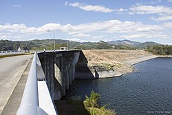
In May 1966, the Philippine Congress passed the Upper Pampanga River Project Act (Republic Act No. 5499) authorizing the construction of the Pantabangan Dam and its appurtenant structures. The groundbreaking ceremony led by then President Ferdinand Marcos took place on June 11, 1971. The project was finally completed in August 1974.
The construction of the Dam had great economic and social impact on the lives of Pantabangeños. About 8,100 hectares (20,000 acres) of productive farmland and the town center (East and West Poblacion) along with seven outlying barangays (Villarica, Liberty, Cadaclan, San Juan, Napon-Napon, Marikit and Conversion) were submerged under the new lake. Residents were relocated to higher ground overlooking the vast reservoir, which became the new Pantabangan town center. Before the expansion of the dam through the Casecnan Project in the 1990s, the belfry of the 18th century church resurfaced from the dam's summer low water level. During drought in 1983, some areas of the old town emerged.[7]
The Pantabangan Dam is claimed [by whom?] to be the second largest dam in Asia, and supplies the irrigation requirements for about 77,000 hectares (190,000 acres) of agricultural lands in Central Luzon. Its power station generates 112 megawatts of hydroelectric power.
In February 1996, then President Fidel V. Ramos led the ground-breaking ceremony of the Casecnan Transbasin Project, a 27 kilometres (17 mi) tunnel from the Casecnan River in Nueva Vizcaya to a terminal point at the Pantabangan reservoir and was commissioned on December 11, 2001. The project aims to augment the capacity of the dam to irrigate an additional 50,000 hectares (120,000 acres) of agricultural land and generate an additional 140 megawatts of hydroelectric power for the Luzon grid.
The present Pantabangan town has 14 barangays and a total land area of about 41,735 hectares. The succeeding years since its relocation saw its progress from a fifth-class municipality in 1975, then to a fourth-class, then to a Municipality in 2006 and finally, in July 2008, pursuant to Section 2 of the Department of Finance Order No. 23-08, Pantabangan was reclassified as First-Class Municipality. It is the only town in the Philippines which boasts of three hydroelectric plants within its territorial jurisdiction.
Geography
[edit]Located in the northern part of Nueva Ecija, Pantabangan is located at the foot of Mt. Mabilog below Mt. Dalimanok which are found between Sierra Madre and Caraballo Mountain ranges. It is home to the Pantabangan–Carranglan Watershed Forest Reserve. It is also the site of the Pantabangan Dam and Lake.
Pantabangan is 51 kilometres (32 mi) from Cabanatuan, 65 kilometres (40 mi) from Palayan, 167 kilometres (104 mi) from Manila, and 139 kilometres (86 mi) from Bayombong.
Barangays
[edit]Pantabangan is politically subdivided into 14 barangays, as shown below. Each barangay consists of puroks and some have sitios.
- Cadaclan
- Cambitala
- Conversion
- Ganduz
- Liberty
- Malbang
- Marikit
- Napon-Napon
- Poblacion East
- Poblacion West
- Sampaloc
- San Juan
- Villarica
- Fatima
Climate
[edit]| Climate data for Pantabangan, Nueva Ecija | |||||||||||||
|---|---|---|---|---|---|---|---|---|---|---|---|---|---|
| Month | Jan | Feb | Mar | Apr | May | Jun | Jul | Aug | Sep | Oct | Nov | Dec | Year |
| Mean daily maximum °C (°F) | 28 (82) |
29 (84) |
30 (86) |
32 (90) |
31 (88) |
30 (86) |
29 (84) |
28 (82) |
28 (82) |
28 (82) |
29 (84) |
28 (82) |
29 (84) |
| Mean daily minimum °C (°F) | 18 (64) |
18 (64) |
19 (66) |
20 (68) |
22 (72) |
22 (72) |
22 (72) |
22 (72) |
22 (72) |
22 (72) |
20 (68) |
18 (64) |
20 (69) |
| Average precipitation mm (inches) | 4 (0.2) |
6 (0.2) |
7 (0.3) |
12 (0.5) |
61 (2.4) |
89 (3.5) |
96 (3.8) |
99 (3.9) |
81 (3.2) |
88 (3.5) |
37 (1.5) |
13 (0.5) |
593 (23.5) |
| Average rainy days | 2.5 | 3.0 | 4.1 | 6.3 | 15.8 | 19.4 | 22.5 | 21.6 | 20.1 | 17.5 | 9.6 | 4.0 | 146.4 |
| Source: Meteoblue[8] | |||||||||||||
Demographics
[edit]
|
| ||||||||||||||||||||||||||||||||||||||||||||||||||||||
| Source: Philippine Statistics Authority[9][10][11][12][13] | |||||||||||||||||||||||||||||||||||||||||||||||||||||||

Languages
[edit]Tagalog is predominantly spoken in Pantabangan, followed by Ilocano. The people of Pantabangan ("Pantabangenian") are also known for their very distinct strong Pantabangan accent, called "Adyu-ari".
Economy
[edit]Poverty incidence of Pantabangan
10
20
30
40
2000
33.84 2003
28.78 2006
34.10 2009
21.84 2012
19.48 2015
24.92 2018
16.01 2021
19.66 Source: Philippine Statistics Authority[14][15][16][17][18][19][20][21] |
Arts and Culture
[edit]
The Pandawan Festival made its debut in April 2008, showcasing many local talents as well as other entertainments including indigenous art activities like art workshop and rural development thru art awareness programs. It features cooking contests, dance competitions and street dancing, and a parade.[22]
Since the completion of the dam, the site of the old town has become visible during times of extremely low water levels in the reservoir coinciding with the El Niño phenomenon, with recorded instances occurring in 1983, 2014, 2020 and 2024, sparking an influx of visitors to the site, particularly the cross of the Saint Andrew Church constructed in 1825.[23] A modern cross was erected in to replace the old during one of its reappearances.[24] The site, which also contains the ruins of the old public cemetery including headstones, foundations of the old municipal hall with its historical town marker, the town plaza and old tree trunks,[25][26] has been designated as a cultural heritage zone by the municipal government.[27]
Transportation
[edit]Much of Pantabangan's population rely on public transportation such as tricycles and jeeps to get around the town.
Education
[edit]The Pantabangan Schools District Office governs all educational institutions within the municipality. It oversees the management and operations of all private and public, from primary to secondary schools.[28]
Primary and elementary schools
[edit]- Cambitala Elementary School
- Conversion Elementary School
- Cadaclan Elementary School
- Ganduz Elementary School
- Kalayaan Elementary School
- Liberty Elementary School
- Masiway Elementary School
- Napon-Napon Elementary School
- Pamalyan Cultural Minority PS
- Pantabangan East Central School
- Pantabangan West Central School
- Salvacion Elementary School
- Sampaloc Elementary School
- San Juan Elementary School
- St. Andrew's School
- Tanawan Central School
- Villanueve Elementary School
Secondary schools
[edit]- Cambitala National High School
- Conversion Integrated School
- Ganduz National High School
- Marikit Integrated School
- Pantabangan National High School
- Pantabangan National High School - Annex (Cadaclan Integrated School)
Gallery
[edit]-
 Pantabangan Dam
 -
 Forests and mountains (Cadaclan)
 -
 Hills and forests (Marikit)


Notable personalities
[edit]- Jason Abalos, a Filipino actor.
References
[edit]- ^ Municipality of Pantabangan | (DILG)
- ^ "2015 Census of Population, Report No. 3 – Population, Land Area, and Population Density" (PDF). Philippine Statistics Authority. Quezon City, Philippines. August 2016. ISSN 0117-1453. Archived (PDF) from the original on May 25, 2021. Retrieved July 16, 2021.
- ^ "2024 Census of Population (POPCEN) Population Counts Declared Official by the President". Philippine Statistics Authority. 17 July 2025. Retrieved 18 July 2025.
- ^ "PSA Releases the 2021 City and Municipal Level Poverty Estimates". Philippine Statistics Authority. 2 April 2024. Retrieved 28 April 2024.
- ^ "2024 Census of Population (POPCEN) Population Counts Declared Official by the President". Philippine Statistics Authority. 17 July 2025. Retrieved 18 July 2025.
- ^ "Alfonso Castañeda". Province of Nueva Vizcaya. Government of the Philippines. Retrieved May 6, 2023.
- ^ "An old submerged town reappears during a drought in the Philippines". Republic of the Philippines. Local Government of Pantabangan. Retrieved 5 June 2022.
- ^ "Pantabangan: Average Temperatures and Rainfall". Meteoblue. Retrieved 4 May 2020.
- ^ "2024 Census of Population (POPCEN) Population Counts Declared Official by the President". Philippine Statistics Authority. 17 July 2025. Retrieved 18 July 2025.
- ^ Census of Population (2015). "Region III (Central Luzon)". Total Population by Province, City, Municipality and Barangay. Philippine Statistics Authority. Retrieved 20 June 2016.
- ^ Census of Population and Housing (2010). "Region III (Central Luzon)" (PDF). Total Population by Province, City, Municipality and Barangay. National Statistics Office. Retrieved 29 June 2016.
- ^ Censuses of Population (1903–2007). "Region III (Central Luzon)". Table 1. Population Enumerated in Various Censuses by Province/Highly Urbanized City: 1903 to 2007. National Statistics Office.
- ^ "Province of". Municipality Population Data. Local Water Utilities Administration Research Division. Retrieved 17 December 2016.
- ^ "Poverty incidence (PI):". Philippine Statistics Authority. Retrieved December 28, 2020.
- ^ "Estimation of Local Poverty in the Philippines" (PDF). Philippine Statistics Authority. 29 November 2005.
- ^ "2003 City and Municipal Level Poverty Estimates" (PDF). Philippine Statistics Authority. 23 March 2009.
- ^ "City and Municipal Level Poverty Estimates; 2006 and 2009" (PDF). Philippine Statistics Authority. 3 August 2012.
- ^ "2012 Municipal and City Level Poverty Estimates" (PDF). Philippine Statistics Authority. 31 May 2016.
- ^ "Municipal and City Level Small Area Poverty Estimates; 2009, 2012 and 2015". Philippine Statistics Authority. 10 July 2019.
- ^ "PSA Releases the 2018 Municipal and City Level Poverty Estimates". Philippine Statistics Authority. 15 December 2021. Retrieved 22 January 2022.
- ^ "PSA Releases the 2021 City and Municipal Level Poverty Estimates". Philippine Statistics Authority. 2 April 2024. Retrieved 28 April 2024.
- ^ Caparas, Celso de Guzman (13 May 2019). "8th Pandawan Festival in Pantabangan, Nueva Ecija". Philippine Star Global.
- ^ "Underwater Town in Nueva Ecija Reemerges Amid El Niño". Esquire. 9 April 2024. Retrieved 25 April 2024.
- ^ "LOOK: Old Pantabangan town reemerges as dam water level drops". ABS-CBN. 25 April 2024. Retrieved 25 April 2024.
- ^ Castro, Pam (April 26, 2024). "Philippine settlement submerged by dam reappears due to drought". Phys.org. Retrieved April 26, 2024.
- ^ Castro, Pam (April 24, 2024). "Philippine settlement submerged by dam reappears due to drought". The Philippine Star. Retrieved April 26, 2024.
- ^ "You can visit the old Pantabangan town in Nueva Ecija that reemerges amid droughts". Rappler. 27 April 2024. Retrieved 27 April 2024.
- ^ "Masterlist of Schools" (PDF). Department of Education. January 15, 2021. Retrieved August 28, 2025.
External links
[edit]- Official website
- Philippine Standard Geographic Code
- Philippine Census Information
- Local Governance Performance Management System Archived 2016-03-04 at the Wayback Machine
Places adjacent to Pantabangan | |
|---|---|
| Municipalities | |
|---|---|
| Component cities | |
| International | |
|---|---|
| National | |
Pantabangan
View on GrokipediaPantabangan is a first-class municipality in the province of Nueva Ecija, Central Luzon region, Philippines, situated in the northern part of the province and encompassing mountainous terrain and forested areas.[1][2] As of the 2020 census, it had a population of 31,763 residents.[2] The municipality is defined by the Pantabangan Dam, an earth-fill embankment structure completed in 1977 that created the Pantabangan Reservoir—one of the largest reservoirs in Southeast Asia and among the cleanest in the Philippines—primarily for irrigation of Central Luzon's farmlands, flood control, and hydroelectric power generation.[3][4][5] Construction of the dam in the 1970s necessitated the relocation of the original town, submerging historic structures including a centuries-old church under the reservoir, which periodically reemerges during severe droughts.[6][7] The reservoir supports local aquaculture initiatives and ecotourism, contributing to economic growth alongside agriculture in the area.[7][8]
History
Early Settlement and Colonial Era
Prior to Spanish arrival, the Pantabangan area was inhabited by three indigenous groups: the Id-Dules (associated with Aetas or Baluga), Id-Talengs, and Irol-les, who maintained settlements in the mountainous terrain of what is now Nueva Ecija.[9][10] These groups engaged in inter-tribal rivalries, with the Id-Dules and Id-Talengs often in conflict, though both remained neutral toward the Irol-les.[10] On November 30, 1645, Augustinian missionary Father Juan Alonzo de Abarca established a Spanish mission in Pantabangan, marking it as the 29th such mission in the Philippines and initiating formal colonial contact.[11][12] This effort focused on Christianization and integration into Spanish administrative structures, transforming the indigenous settlements into a growing pueblo under missionary oversight.[9] The settlement expanded during the Spanish colonial period, with the village officially recognized and included on Philippine maps by 1747.[13] Augustinian missionaries constructed the St. Andrew the Apostle Parish Church, which served as a central institution for religious and communal life, reflecting the enduring Spanish influence on local architecture and governance until the late 19th century.[14] As part of broader Nueva Ecija settlements, Pantabangan contributed to regional defense and evangelization strategies amid ongoing interactions with surrounding indigenous populations.[15]American Period and Pre-Dam Development
During the American colonial administration, which began following the Treaty of Paris in 1898, Pantabangan transitioned from a Spanish-era visita to a formally recognized municipality in 1900, reflecting broader U.S. efforts to reorganize local governance through the Philippine Commission.[13] This elevation aligned with administrative reforms in Nueva Ecija, where upland settlements like Pantabangan and neighboring Carranglan were upgraded to independent pueblos to facilitate centralized control, taxation, and infrastructure provision.[16] American authorities introduced public education systems, establishing primary schools that emphasized English-language instruction and practical skills, though enrollment in remote areas like Pantabangan remained limited due to geographic isolation and low population density.[17] The local economy centered on subsistence agriculture, with lowland barangays along the Pampanga River supporting wet-rice cultivation dependent on seasonal flooding and rudimentary irrigation canals, while upland areas relied on kaingin (slash-and-burn) methods for corn, root crops, and vegetables.[18] Timber extraction from surrounding forests provided supplementary income, though unregulated logging contributed to soil erosion in the watershed; U.S. surveys in the early 1900s noted the potential for hydroelectric development but prioritized agricultural stability over large-scale projects.[19] Population growth was modest, with estimates placing residents at a few thousand by the 1930s, sustained by migration from lowlands seeking arable land amid hacienda expansions elsewhere in Nueva Ecija.[20] By the interwar period and into the Commonwealth era (1935–1946), limited road networks improved access to Cabanatuan markets, enabling modest trade in palay (unhusked rice) and livestock, though Pantabangan's remoteness hindered commercialization compared to central plains municipalities.[15] Japanese occupation from 1942 disrupted this, but U.S. liberation forces bombarded the area in January 1945 to dislodge Imperial Army positions, causing significant destruction to structures and farmland before postwar reconstruction under the Philippine Republic.[10] Pre-dam development in the 1950s–1960s focused on agricultural intensification, with government extension services promoting hybrid seeds and fertilizers to boost yields, though persistent upland poverty and deforestation persisted until feasibility studies for the Pantabangan Reservoir initiated in 1962 highlighted the valley's flood-prone topography for multipurpose dam utilization.Dam Construction and Community Relocation (1960s-1970s)
The Pantabangan Dam project emerged in the early 1960s as a component of the Upper Pampanga River Irrigation Project, designed to deliver irrigation, flood control, and hydroelectric power to central Luzon. A feasibility study by the National Irrigation Administration, supported by the US Bureau of Reclamation, concluded in 1966, prompting a World Bank loan request in 1968 that was approved for $34 million in August 1969.[21] Philippine Congress enacted Republic Act No. 5499 in May 1969 to authorize the development.[3] Construction initiated on March 3, 1971, with President Ferdinand Marcos presiding over the groundbreaking on June 11, 1971.[22][3] The earth-fill dam reached completion in August 1974, ahead of some projections, and was inaugurated on September 7, 1974, though full project elements like the power plant extended into 1977.[22] The structure, standing 107 meters high and spanning 1,615 meters, created a reservoir covering 3 billion cubic meters and inundating over 8,000 hectares, including six barangays of the original Pantabangan town.[22] To accommodate the reservoir, authorities displaced 2,300 families—approximately 13,000 individuals—from the town and reservoir zone during the early 1970s.[21] Resettlement efforts placed 187 families on irrigated lands within the dam's service area, while 2,116 families opted for sites in four nearby hilly areas, reflecting community preferences amid limited alternatives.[21] The process incurred significant overruns, escalating from a $1.1 million appraisal to $11.7 million in actual expenditure, exacerbated by insufficient initial planning, political influences, and post-relocation livelihood struggles that prompted some families to clear forests for agriculture.[21] The submerged settlement, encompassing the historic St. Andrew the Apostle Parish Church and other structures dating to the colonial era, periodically resurfaces during low water levels.[23]Post-Dam Era and Recent Events (1980s-2025)
Following the completion of the Pantabangan Dam in 1977 and the relocation of the original community to New Pantabangan, the 1980s marked the stabilization of dam operations under the National Irrigation Administration and National Power Corporation, with the hydroelectric plant fully commissioned and generating up to 112 megawatts initially, supporting irrigation for 77,000 hectares of farmland and contributing to regional flood mitigation.[24][19] Streamflow data indicated peak annual volumes in the prior decade, but operations adapted to variable inflows, aiding agricultural productivity in downstream areas amid Nueva Ecija's rice-dependent economy. Throughout the late 20th and early 21st centuries, the dam has managed flood risks from typhoons affecting the Pampanga River Basin, including controlled releases during events like Typhoons Ditang and Edeng in July 2000, which caused widespread inundation but were moderated by reservoir storage. In August 2006, the reservoir reached near-spillway levels for the first time in 28 years due to prolonged heavy rains, prompting heightened monitoring to prevent overflows.[25] Climate trends showed rising temperatures (0.22–0.24°C per decade from 1960–2001) and slightly declining rainfall, influencing operational adjustments for hydropower and irrigation reliability.[26] In recent years, extreme weather has periodically exposed the submerged ruins of the original 300-year-old town during low reservoir levels, occurring six times since construction; a notable instance in April 2024 saw water drop 26 meters amid El Niño-induced drought and record heat, drawing tourists to view church remnants and tombstones otherwise hidden underwater.[27][28] Infrastructure enhancements include refurbishment of the hydropower turbines to boost capacity to 132 MW, while emerging renewable initiatives feature the pre-construction phase of a wind power project and a 160 MW wind farm development awarded to ACCIONA Energía in November 2023, alongside First Gen Hydro's 100 MW Aya Pumped-Storage Project initiated around 2019, signaling diversification beyond traditional dam functions.[29][30][31][32]Geography and Environment
Location, Topography, and Hydrography
Pantabangan is a landlocked municipality situated in Nueva Ecija province, Central Luzon region, Philippines, at coordinates 15° 48' North, 121° 9' East.[2] It occupies the eastern sector of the province, bordered by Carranglan to the north, Alfonso Castañeda in Nueva Vizcaya to the east, Rizal to the south, and San Jose City to the west.[19] The total land area measures 392.56 square kilometers, representing 6.90% of Nueva Ecija's provincial area.[2] The topography consists of hilly and mountainous landscapes with pronounced elevation changes, characteristic of the eastern uplands transitioning from central plains.[33] The municipal center elevates to 315.9 meters above sea level, amid average regional elevations of about 258 meters and local variations exceeding 300 meters within short distances.[2][34][35] The hydrography centers on the Pantabangan Reservoir, formed by the earth-fill Pantabangan Dam across the Pantabangan River, a tributary in the Pampanga River basin.[19] This reservoir, the largest in the Philippines with a capacity of three billion cubic meters, receives inflows from six major rivers originating in the Caraballo and Sierra Madre ranges, supporting irrigation for over 100,000 hectares, hydroelectric generation, and flood mitigation downstream.[36][37]Administrative Barangays
Pantabangan is administratively subdivided into 14 barangays, the smallest local government units in the Philippines responsible for grassroots administration, community services, and local ordinances.[2] These barangays encompass both the town proper and surrounding rural areas, with some situated along the Pantabangan Reservoir's periphery, influencing local zoning for agriculture, tourism, and reservoir-related activities. The division reflects historical settlements adjusted post-dam construction in the 1970s, when certain communities were relocated but retained barangay status.[2] The following table lists the barangays, along with their recorded populations from the 2020 Census of Population and Housing conducted by the Philippine Statistics Authority:| Barangay | Population (2020) |
|---|---|
| Cadaclan | 2,632 |
| Cambitala | 2,079 |
| Conversion | 2,743 |
| Fatima | 1,192 |
| Ganduz | 2,492 |
| Liberty | 1,193 |
| Malbang | 2,808 |
| Marikit | 2,582 |
| Napon-Napon | 1,226 |
| Poblacion East | 3,757 |
| Poblacion West | 2,625 |
| Sampaloc | 2,086 |
| San Juan | 2,435 |
| Villarica | 1,913 |
Climate Patterns and Variability
Pantabangan experiences a tropical monsoon climate, marked by consistently warm temperatures and distinct wet and dry seasons. Average annual high temperatures reach 29.3°C, with lows around 21.4°C, varying little year-round due to the equatorial proximity, though diurnal ranges can exceed 10°C in the elevated terrain.[38] The dry season spans December to May, with minimal rainfall and higher evaporation rates, while the wet season from June to November delivers the bulk of precipitation via the southwest monsoon (habagat), often exceeding 80% of the annual total.[35] Annual rainfall in the broader Nueva Ecija region, including Pantabangan, averages 1,937 to 2,142 mm, concentrated in intense bursts that support rice cultivation but risk flooding in low-lying areas.[39][40] Peak monthly precipitation occurs in July and August, often surpassing 300 mm, while February and March see under 50 mm. Humidity remains high year-round, averaging 80-85%, amplifying perceived heat during the dry period.[41] Climate variability is pronounced, driven by the El Niño-Southern Oscillation (ENSO) and tropical cyclone activity. El Niño episodes induce droughts, reducing inflows to the Pantabangan reservoir; for instance, in 2024, prolonged dry conditions linked to El Niño lowered dam levels by over 50 meters, exposing historical ruins and straining water supply.[28] La Niña phases, conversely, enhance monsoon rains and typhoon intensity, exacerbating floods. Nueva Ecija encounters an average of seven typhoons annually, many crossing the province and triggering landslides in the mountainous watershed, with events like Typhoon Koppu in 2015 devastating crops across flooded fields.[42][43] Research on the Pantabangan-Carranglan watershed highlights vulnerability to these extremes, where delayed rainy season onsets and strong typhoons disproportionately impact smallholder farmers through crop failures and livelihood disruptions, underscoring the need for adaptive irrigation reliant on dam storage.[44] Long-term trends suggest increasing variability, with PAGASA noting shifts in monsoon timing amid broader Philippine climate patterns.[45]Pantabangan Dam
Engineering and Construction
The Pantabangan Dam is an embankment-type structure designed as a multi-purpose facility for irrigation, flood control, and hydroelectric power generation on the Pampanga River. It stands 107 meters high and extends 1,615 meters in length, constructed primarily from homogeneous earth-fill material totaling approximately 12 million cubic yards.[3] The dam features a central clay core for imperviousness, surrounded by zoned earth and rockfill zones to enhance stability, with materials sourced from nearby borrow areas including conglomeratic clay from the right bank upstream.[46] Construction commenced on March 3, 1971, as part of the Upper Pampanga River Integrated Irrigation Project (UPRIIS), funded in part by a World Bank loan.[22] The project involved extensive earthworks, requiring coordinated efforts from civil engineers, equipment operators, and laborers across multiple specialties to handle the massive volume of fill and ensure structural integrity in a seismically active region.[47] Key phases included site preparation, foundation treatment, and progressive embankment building, with the main dam body reaching completion in August 1974.[48] The spillway, an ungated open chute with a semi-circular intake, was engineered to discharge up to 4,540 cubic meters per second at a water elevation of 241.26 meters, providing critical flood mitigation capacity. Inauguration occurred on September 7, 1974, though full operational integration, including the hydroelectric components, extended to 1977, reflecting the complexity of integrating power generation infrastructure.[22] Seismic design considerations incorporated site-specific geology, embankment type selection, and structural reinforcements to withstand ground motions prevalent in the Philippines.[49]Operational Functions and Capacity
The Pantabangan Dam operates as a multi-purpose infrastructure, primarily facilitating irrigation for the Upper Pampanga River Integrated Irrigation System (UPRIIS), which services approximately 120,000 hectares of farmland in Central Luzon provinces including Nueva Ecija, Tarlac, Pampanga, Bulacan, and Aurora.[50] Water releases from the reservoir are regulated to support multiple cropping seasons, with peak demands during the dry season to sustain rice production in downstream areas.[22] The dam's irrigation function is prioritized in operational protocols, with daily releases coordinated by the National Irrigation Administration (NIA) to meet agricultural needs while minimizing downstream flooding risks.[3] In addition to irrigation, the dam provides flood control by allocating 486 million cubic meters of its reservoir volume specifically for attenuating peak inflows during typhoon seasons, reducing overflow into the Pampanga River basin.[46] The spillway, designed for a maximum discharge of 4,200 cubic meters per second, enables controlled releases to prevent catastrophic downstream inundation, as demonstrated in operations during major storms since its completion in 1974.[3] Reservoir levels are monitored to maintain this flood storage, with active management drawing on hydrological data to balance storage against irrigation and power demands.[22] Hydroelectric power generation occurs via a powerhouse at the dam's base, equipped with two Francis turbine-generators providing an installed capacity of 100 megawatts, operational since April 1977.[3] This output contributes to the national grid, with dependable capacity estimated at around 70 megawatts under typical hydrological conditions, though actual generation varies with water availability and is subordinate to irrigation priorities.[22] The overall reservoir has a gross storage capacity of 2.996 billion cubic meters, of which 2.083 billion cubic meters is active for these combined uses.[3] Operations integrate real-time inflow forecasting to optimize power peaking while preserving water for primary agricultural functions.[46]Economic and Social Impacts: Achievements and Criticisms
The Pantabangan Dam has generated substantial economic benefits primarily through irrigation, hydroelectric power, and flood mitigation. Its reservoir supplies water to the Upper Pampanga River Integrated Irrigation System, irrigating approximately 77,000 hectares of agricultural land across 24 municipalities in Nueva Ecija, Bulacan, and Pampanga, bolstering rice production in Central Luzon, which accounts for a significant portion of national output.[44] The associated hydroelectric plant, commissioned in 1977 with two 60 MW turbines for a total capacity of 120 MW, provides reliable baseload power to the grid, originally contributing around 112 MW of dependable capacity and supporting renewable energy goals.[51][22] Flood control functions yield annual benefits estimated at US$500,000 by reducing downstream inundation risks in the Pampanga River basin.[46] Project evaluations indicate an economic internal rate of return of 14% over a 50-year horizon, justifying investments through enhanced agricultural productivity and energy security.[21] Social impacts include the forced relocation of approximately 1,000 families from the original Pantabangan town between 1971 and 1973 to New Pantabangan and other sites, submerging historical structures like the 300-year-old St. Andrew the Apostle Parish Church under the reservoir.[52] While resettlement provided new housing and access to modern infrastructure, it triggered outmigration waves in the 1970s–1980s, socio-economic disruptions, and cultural disconnection from ancestral lands, with qualitative assessments noting heightened vulnerability to climate variability in affected communities.[44] Criticisms center on resettlement shortcomings, including delays that exacerbated psychological strain, environmental degradation, and impoverishment, as documented in analyses of development-induced displacement where land expropriation without adequate compensation led to livelihood losses.[53] Scholarly reviews, such as those examining state-mediated resettlements, argue that Pantabangan exemplifies how such projects can entrench poverty through inadequate post-relocation support and failure to restore pre-dam living standards.[54] Long-term siltation has also reduced reservoir efficacy, indirectly straining economic outputs like power generation, which operates at about 30% of capacity as of 2024 due to aging infrastructure.[55] Despite these, proponents highlight adaptive benefits, such as tourism from resurfacing ruins during droughts, which has provided supplemental income to locals.[28]Demographics
Population Dynamics and Trends
The population of Pantabangan underwent notable fluctuations in the mid-20th century, with steady pre-war growth from 1,151 residents in 1903 accelerating to around 5,000 by the 1940s, before stabilizing amid post-war recovery efforts.[2] The construction of the Pantabangan Dam, completed in 1974, led to the inundation of the original townsite and the relocation of several hundred families to higher elevations, triggering significant outmigration through the 1970s and 1980s as displaced residents sought opportunities elsewhere.[56] Post-relocation stabilization occurred by the 1990s, with population rebounding to 27,353 by the 2010 Census of Population and Housing, driven by natural increase and return migration tied to dam-related economic activities such as irrigation-supported agriculture.[2] From 2010 to 2020, the populace expanded to 31,763, marking an average annual growth rate of approximately 1.5%, though this moderated to 1.26% between 2015 and 2020 amid rural-urban shifts.[2][57]| Census Year | Population | Annual Growth Rate (Prior Period) |
|---|---|---|
| 2010 | 27,353 | - |
| 2015 | 29,925 | ~1.8% (2010-2015) |
| 2020 | 31,763 | 1.26% (2015-2020) |
Ethnic Composition and Languages
The ethnic composition of Pantabangan reflects the broader patterns in Nueva Ecija province, where the majority of residents are of Tagalog ethnicity, with a significant minority of Ilocano descent due to historical migrations from northern Luzon regions.[60] Other groups, including small numbers of Kapampangans and indigenous peoples such as the Kalanguya in adjacent upland areas, contribute to the diversity, though they represent minor proportions at the municipal level.[61] This mix stems from colonial-era settlements by Tagalogs and 20th-century Ilocano influxes encouraged by land availability in Central Luzon.[62] The primary languages spoken in Pantabangan are Tagalog, which serves as the dominant vernacular and basis for local dialects, and Ilocano, used particularly among families with northern origins.[63] The local Tagalog variant incorporates some Ilocano lexical influences, resulting in a distinct regional accent characterized by stronger intonations.[64] Filipino (standardized Tagalog) and English function as official languages for administration and education, with widespread bilingualism ensuring accessibility in governance and commerce. Indigenous languages like those of the Kalanguya may persist in remote barangays but are not predominant.[62]Economy
Agriculture and Irrigation Dependency
Agriculture in the Pantabangan-Carranglan Watershed, encompassing the municipality of Pantabangan, features rice, corn, onions, and vegetables as primary crops, though production is constrained by the area's mountainous terrain and limited arable flatlands.[65] Local farming often incorporates agroforestry practices to integrate crop cultivation with forest conservation, reflecting the watershed's role in upstream water management.[19] The Pantabangan Dam, located within the municipality, is integral to regional agricultural sustainability through the Upper Pampanga River Integrated Irrigation System (UPRIIS), which channels reservoir water to irrigate approximately 84,000 hectares of farmland across Central Luzon, including parts of Nueva Ecija, Bulacan, and Pampanga.[66] This system supports over 62,000 farmers in 24 municipalities, enabling dry-season rice cropping that would otherwise be infeasible due to insufficient rainfall. The dam's reservoir, with an active storage capacity of 2.083 billion cubic meters, facilitates controlled releases, such as the 72,618 hectares irrigated in 2023 despite low water levels.[3][67] Irrigation dependency is acute during dry periods, with water allocation directly tied to reservoir elevations; for instance, levels below optimal thresholds prompt minimal releases prioritizing reproductive-stage crops, as seen in 2020 cloud-seeding efforts to bolster supply.[68] Variability in dam inflows, influenced by upstream watershed conditions, underscores the vulnerability of local and downstream agriculture to climate fluctuations, necessitating adaptive management by the National Irrigation Administration to sustain yields.[69][44]Energy Generation and Renewable Projects
The Pantabangan hydroelectric power plant, integrated into the Pantabangan Dam structure on the Pampanga River, features an installed capacity of 120 MW from two Francis turbines, operational since 1977 and contributing to baseload and peaking power in the Luzon grid.[70] The adjacent Masiway Dam adds capacity to the complex, with the combined Pantabangan-Masiway system totaling approximately 132 MW under management by affiliates of First Gen Corporation.[71] Additionally, the 165 MW Casecnan run-of-river hydroelectric plant, located within Pantabangan municipality, operates independently but enhances local renewable hydro output through diversion from the Casecnan River into the Pantabangan Reservoir.[72] Renewable energy initiatives in Pantabangan emphasize expansion beyond traditional hydro. In February 2024, the Philippine Board of Investments fast-tracked Fuego Renewable Energy Corporation's proposed 463.995 MW floating solar photovoltaic project on Pantabangan Lake, utilizing approximately 500 hectares of the reservoir surface for panels to generate clean power while minimizing land use conflicts.[73][74] First Gen Corporation is scouting sites near the Pantabangan-Masiway facilities for ground-mounted solar farms, onshore wind projects, and battery energy storage systems to integrate intermittent renewables with existing hydro infrastructure.[75] A pre-construction wind farm project in Pantabangan further signals diversification into aerogeneration.[30] Hydro augmentation persists through planned developments, including a memorandum of understanding signed in October 2019 between the National Irrigation Administration and First Gen for a new hydroelectric facility at the Aya Dam site in Pantabangan, alongside exploration of pumped-storage enhancements to the broader complex for improved grid stability.[76][71] These projects align with national targets for 35% renewable energy share by 2030, leveraging Pantabangan's reservoirs and topography for hybrid systems that mitigate hydro variability with solar and storage.[77]Tourism and Emerging Opportunities
Pantabangan's tourism sector centers on its reservoir and surrounding natural landscapes, drawing visitors for water-based recreation and scenic viewpoints. The Pantabangan Dam and its view deck provide panoramic overlooks of the reservoir, supporting activities such as boating, fishing, and picnicking, with the site ranking as one of the most visited attractions due to its accessibility and recreational facilities.[78] During low water levels, typically in the dry season, the submerged ruins of the old St. Andrew the Apostle Parish Church emerge, enabling unique diving and snorkeling experiences that reveal historical artifacts from the pre-dam village.[79] Agri-tourism initiatives, exemplified by Farm Ridge by Desmond Farm, integrate agricultural demonstrations with nature trails and wellness activities, fostering visitor engagement with local farming practices and serene environments.[80] Other sites like Tayabo Nature Park offer hiking paths amid forests and hills, promoting eco-friendly exploration of the area's biodiversity.[81] These attractions contributed to Pantabangan's recognition as an emerging ecocultural destination, with local efforts emphasizing sustainable practices to preserve natural resources.[82] Emerging opportunities lie in expanding agri-tourism and infrastructure to boost economic diversification beyond agriculture and hydropower. Studies indicate high tourist satisfaction at sites like Lake Farm Dela Marre, where integrated farm experiences drive repeat visits and potential business growth, though challenges persist in facilities like accommodations and transportation.[83] Developments such as improved view decks and trail networks could attract more domestic travelers, stimulating job creation in hospitality and guiding services while leveraging the reservoir's capacity for adventure sports like kayaking and rafting.[84] Strategic planning informed by community involvement aims to enhance facilities without overburdening ecosystems, positioning Pantabangan for sustainable growth in Central Luzon's tourism landscape.[85]Governance and Infrastructure
Local Administration and Politics
Pantabangan operates as a first-class municipality under the Local Government Code of 1991, with executive authority vested in an elected mayor responsible for policy implementation, budget execution, and public services delivery. The legislative branch, the Sangguniang Bayan, comprises a vice mayor as presiding officer and eight elected councilors who enact ordinances, approve budgets, and oversee development plans. As of October 2025, Monaliza Agdipa serves as mayor, having transitioned from vice mayor after winning the position in the May 12, 2025, local elections and assuming office on June 30, 2025. Her predecessor, Roberto T. Agdipa, held the mayoralty from at least 2022 to 2025, focusing on local initiatives including tourism events.[86] The municipality is subdivided into 14 barangays—Cadaclan, Cambitala, Conversion, Ganduz, Liberty, Malbang, Marikit, Napon-Napon, Poblacion East, Poblacion West, Sampaloc, San Juan, and two others—each governed by an elected barangay captain and kagawads who manage grassroots administration and community projects.[2] Local politics align with provincial dynamics in Nueva Ecija, where the Agdipa family has maintained influence through successive electoral wins. Pantabangan's officials engage in the League of Municipalities of the Philippines (LMP) Nueva Ecija chapter, which coordinates advocacy on municipal governance issues for the 2025–2028 term. No major partisan conflicts or shifts have been documented in recent cycles, with elections emphasizing infrastructure and dam-related economic priorities.[87]Transportation and Connectivity
Pantabangan's transportation infrastructure relies primarily on road networks, with no dedicated rail or air facilities within the municipality; the nearest airport is Clark International Airport, approximately 100 kilometers southwest. Access from Manila typically involves buses operated by companies such as Cisco Bus Co., departing from terminals like Cubao, to intermediate points such as Talugtug in Nueva Ecija, followed by a taxi or jeepney ride covering the remaining distance to Pantabangan, totaling around 6-7 hours and costing approximately ₱1,300 as of recent estimates.[88] Return trips from Talugtug to Cubao take about 4 hours via the same bus service, with fares at ₱462.[89] Key connectivity is provided by provincial and barangay roads linking Pantabangan to Cabanatuan City, the provincial capital 50 kilometers west, and to neighboring Aurora province via the Pantabangan-Canili Road. Improvements to the 4-kilometer Pantabangan-Canili bypass road, completed by late 2022 under the Department of Public Works and Highways, have enhanced travel efficiency to Baler in Aurora, reducing congestion and improving safety on this route through mountainous terrain.[90] Local transport within Pantabangan includes tricycles and vans, commonly used for short distances to sites like the dam or rural barangays, while jeepneys serve inter-barangay routes.[91] Rural access has been bolstered by farm-to-market roads, such as the 2019-constructed route from Sitio Sinipit to Sitio Pamalyan in Barangay Conversion, benefiting over 350 upland farmers by connecting isolated areas to main highways.[92] Overall, while road density supports basic mobility, the municipality's location in the Sierra Madre foothills limits high-speed connectivity, with ongoing upgrades focusing on resilience against typhoons and landslides common in the region.[93]Utilities and Modern Developments
The Pantabangan hydroelectric power plant, with an installed capacity of 100 MW from two Francis turbine-generators, forms a core component of local electricity generation as part of the 132 MW Pantabangan-Masiway complex operated by First Gen Hydro Power Corporation.[72][51] This facility, commissioned in 1977, contributes to the national grid, supporting regional power needs including distribution to Pantabangan municipality, where service has historically involved direct arrangements with the operator amid past disputes over unpaid municipal bills exceeding P80 million in 2013.[94] Electricity distribution in the area falls under the oversight of the local government, distinct from neighboring cooperatives like NEECO II, which administers adjacent towns.[95] Water supply in Pantabangan is managed through the Pantabangan Municipal Water System (PMWS), operated by the local government unit (LGU), supplemented by deep wells, spring developments, and contributions from the National Irrigation Administration's water works.[19] The Pantabangan Dam reservoir also serves domestic water needs alongside its primary roles in irrigation and power generation.[36] In 2020, First Gen Hydro donated P33 million to enhance the system via well drilling and pipe laying, addressing coverage gaps in the municipality.[96] Sanitation infrastructure remains rudimentary, relying predominantly on individual septic systems typical of rural Philippine settings, with no centralized sewage treatment facilities documented for the area. Modern developments emphasize renewable energy expansion, with First Gen identifying sites near existing hydro facilities for solar, wind, and battery energy storage systems as of 2024.[75] The 480 MW TITAN I Solar Power Project in barangays Cambitala and San Juan, Pantabangan, is slated for commissioning by October 2026, integrating into national transmission plans.[97] Additionally, a planned 120 MW pumped-storage hydroelectric plant aims to bolster capacity, while the 165 MW Casecnan run-of-river plant in Pantabangan was transferred to First Gen operations in February 2024.[98][99] Telecommunications access includes local internet providers like NLINK and emerging satellite options such as Starlink, supporting connectivity in remote areas.[100][101]Culture and Society
Traditional Arts, Festivals, and Heritage
The Pandawan Festival, held annually during the last week of April, celebrates the bountiful fish harvest from Pantabangan Lake and honors Saint John the Baptist through street parades, dance competitions, and cultural presentations by local groups.[102][103] This event underscores the municipality's reliance on aquaculture while incorporating traditional performances that highlight community heritage.[104] Folk painting represents a key traditional art form in Pantabangan, prominently featured through the works of local artist Amangpintor (Lito Circa), born in 1970 in the original town site. His paintings document the submergence of old Pantabangan and daily life using indigenous materials like human hair and blood, fostering cultural preservation via the Samahang Makasining artists' group, which grew to 1,500 members under his influence.[105] The Amangpintor Art Museum exhibits these pieces alongside other local artworks depicting the town's history and traditions.[106] Pantabangan's heritage revolves around the remnants of its original settlement, a 300-year-old town submerged in the 1970s to form the reservoir for Pantabangan Dam, with operations commencing in 1977.[107] Key sites include the ruins of the 19th-century St. Andrew the Apostle Parish Church, constructed by Augustinian missionaries, which periodically resurface during low water levels, as seen in April 2024 amid prolonged drought and heat.[108][109][110] These structures, including tombstones and foundations, preserve traces of indigenous Negrito groups and Spanish colonial evangelization dating to the 17th century, serving as tangible links to pre-dam history despite the relocation of residents.[111]Notable Individuals and Contributions
Jason Abalos, born on January 14, 1985, in Pantabangan, Nueva Ecija, is a Filipino actor, model, host, and politician who has gained prominence in the entertainment industry through roles in GMA Network productions.[112] He holds a bachelor's degree in civil engineering from Nueva Ecija University of Science and Technology and transitioned into politics, securing election to the Nueva Ecija Sangguniang Panlalawigan in 2022 and re-election for a second term in May 2025.[113][114] Abalos's dual career has elevated Pantabangan's visibility nationally, blending media influence with local governance advocacy. Elito V. Circa, born on January 28, 1970, in the original Pantabangan town site (now submerged under the reservoir), is a self-taught folk artist renowned for his unconventional use of human blood and hair as painting mediums, earning him recognition as the "Pantabangan Folk Painter" by the National Commission for Culture and the Arts.[105] From a farming family, Circa has produced works depicting local history, including a 122 by 244 cm blood mural chronicling Pantabangan's heritage, completed over months and drawing international attention for its visceral symbolism tied to personal and communal identity.[115] His art preserves cultural narratives of the area's pre-dam era and indigenous roots, contributing to the promotion of Philippine folk traditions amid modernization.[106]References
- https://en.wikivoyage.org/wiki/Nueva_Ecija