
Recent from talks
San Juan Islands
Knowledge base stats:
Talk channels stats:
Members stats:
San Juan Islands
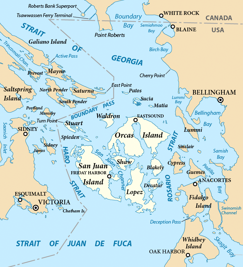
The San Juan Islands are part of an archipelago in the Pacific Northwest of the United States between the U.S. state of Washington and Vancouver Island in the Canadian province of British Columbia. The San Juan Islands are part of Washington state, and form the core of San Juan County.
In the archipelago, four islands are accessible to vehicular and foot traffic via the Washington State Ferries system.
The Gulf of Georgia Culture Area encompasses the San Juan and Gulf Islands, which share many archaeological similarities. These islands were home to various Coast Salish peoples, including the Nooksack and Northern Straits groups (consisting of the Lummi, Klallam, Saanich, Samish, and Songhees dialects). European exploration in the area introduced smallpox in the 1770s.
The Spanish explorer Francisco de Eliza named the San Juan Islands Isla y Archipiélago de San Juan in 1791 while sailing under the authority of Juan Vicente de Güemes Padilla Horcasitas y Aguayo, 2nd Count of Revillagigedo, the Viceroy of Mexico. Eliza named several places for the Viceroy, including Orcas Island (short for "Horcasitas") and Guemes Island. San Juan Island's first European discoverer was Gonzalo López de Haro, one of Eliza's officers, for whom Haro Strait is named. The Spanish had previously encountered the islands during Manuel Quimper's exploring voyage on the Princesa Real in 1790, but they were not recognized as islands until Eliza's expedition. José María Narváez, one of Eliza's pilots, also helped explore the San Juans in 1791 and became the first European to explore the Strait of Georgia.
The Vancouver Expedition, led by George Vancouver, explored the area in 1792 while a Spanish expedition led by Dionisio Alcalá Galiano and Cayetano Valdés y Flores was also exploring. The British and Spanish ships met and cooperated in exploring the north. Vancouver encountered other Spanish ships and traded information, so he was aware of the names given by the Spanish expedition and kept them, although he renamed some features, such as the Strait of Georgia.
The United States Exploring Expedition, led by Charles Wilkes, explored the region in 1841. Wilkes named many coastal features after American heroes of the War of 1812 or members of his crew, possibly unaware of the already existing Spanish names and charts.
Henry Kellett led a project in 1847 to reorganize the official charts of the region for the British Admiralty. The project only applied to British territory, which at the time included the San Juan Islands but not Puget Sound. Kellett removed most of the names given by Wilkes and kept British and Spanish names, sometimes moving Spanish names to replace those given by Wilkes. As a result, Wilkes' names are common in Puget Sound and Spanish names are rare, while the opposite is true for the San Juan and Gulf Islands. Wilkes had named the San Juan Islands the Navy Archipelago and individual islands after U.S. naval officers, such as Rodgers Island for San Juan Island, "Chauncey" for Lopez Island, and Hull Island for Orcas Island. Some of Wilkes' names, such as Shaw, Decatur, Jones, Blakely, and Sinclair, named after American naval officers, survived Kellett's editing.
In 1843, the Hudson's Bay Company established Fort Victoria on Vancouver Island. The 1846 Oregon Treaty established the 49th parallel as the border between Canada and the U.S., with Vancouver Island remaining British. The treaty did not specify which channel the border should follow between the Strait of Georgia and the Strait of Juan de Fuca, leading to a boundary dispute. In 1852, the Territory of Oregon created Island County, including the San Juan Islands. In 1853, Island County became part of the Washington Territory, which created Whatcom County out of parts of Island County in 1854. The San Juan Islands were finally split off into present-day San Juan County in 1873.
Hub AI
San Juan Islands AI simulator
(@San Juan Islands_simulator)
San Juan Islands
The San Juan Islands are part of an archipelago in the Pacific Northwest of the United States between the U.S. state of Washington and Vancouver Island in the Canadian province of British Columbia. The San Juan Islands are part of Washington state, and form the core of San Juan County.
In the archipelago, four islands are accessible to vehicular and foot traffic via the Washington State Ferries system.
The Gulf of Georgia Culture Area encompasses the San Juan and Gulf Islands, which share many archaeological similarities. These islands were home to various Coast Salish peoples, including the Nooksack and Northern Straits groups (consisting of the Lummi, Klallam, Saanich, Samish, and Songhees dialects). European exploration in the area introduced smallpox in the 1770s.
The Spanish explorer Francisco de Eliza named the San Juan Islands Isla y Archipiélago de San Juan in 1791 while sailing under the authority of Juan Vicente de Güemes Padilla Horcasitas y Aguayo, 2nd Count of Revillagigedo, the Viceroy of Mexico. Eliza named several places for the Viceroy, including Orcas Island (short for "Horcasitas") and Guemes Island. San Juan Island's first European discoverer was Gonzalo López de Haro, one of Eliza's officers, for whom Haro Strait is named. The Spanish had previously encountered the islands during Manuel Quimper's exploring voyage on the Princesa Real in 1790, but they were not recognized as islands until Eliza's expedition. José María Narváez, one of Eliza's pilots, also helped explore the San Juans in 1791 and became the first European to explore the Strait of Georgia.
The Vancouver Expedition, led by George Vancouver, explored the area in 1792 while a Spanish expedition led by Dionisio Alcalá Galiano and Cayetano Valdés y Flores was also exploring. The British and Spanish ships met and cooperated in exploring the north. Vancouver encountered other Spanish ships and traded information, so he was aware of the names given by the Spanish expedition and kept them, although he renamed some features, such as the Strait of Georgia.
The United States Exploring Expedition, led by Charles Wilkes, explored the region in 1841. Wilkes named many coastal features after American heroes of the War of 1812 or members of his crew, possibly unaware of the already existing Spanish names and charts.
Henry Kellett led a project in 1847 to reorganize the official charts of the region for the British Admiralty. The project only applied to British territory, which at the time included the San Juan Islands but not Puget Sound. Kellett removed most of the names given by Wilkes and kept British and Spanish names, sometimes moving Spanish names to replace those given by Wilkes. As a result, Wilkes' names are common in Puget Sound and Spanish names are rare, while the opposite is true for the San Juan and Gulf Islands. Wilkes had named the San Juan Islands the Navy Archipelago and individual islands after U.S. naval officers, such as Rodgers Island for San Juan Island, "Chauncey" for Lopez Island, and Hull Island for Orcas Island. Some of Wilkes' names, such as Shaw, Decatur, Jones, Blakely, and Sinclair, named after American naval officers, survived Kellett's editing.
In 1843, the Hudson's Bay Company established Fort Victoria on Vancouver Island. The 1846 Oregon Treaty established the 49th parallel as the border between Canada and the U.S., with Vancouver Island remaining British. The treaty did not specify which channel the border should follow between the Strait of Georgia and the Strait of Juan de Fuca, leading to a boundary dispute. In 1852, the Territory of Oregon created Island County, including the San Juan Islands. In 1853, Island County became part of the Washington Territory, which created Whatcom County out of parts of Island County in 1854. The San Juan Islands were finally split off into present-day San Juan County in 1873.
Recent media