Hubbry Logo
Strait of GeorgiaStrait of GeorgiaMain
Open search
Strait of Georgia
Community hub
Strait of Georgia
logo
8 pages, 0 posts
0 subscribers
Be the first to start a discussion here.
Strait of Georgia
Strait of Georgia
from Wikipedia
Looking west across the Straight from Iona Park in Richmond towards Gabriola and Valdes Islands.

Key Information

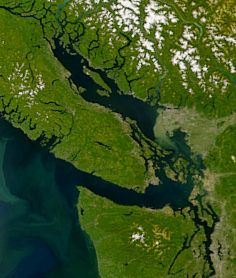
The Strait of Georgia (French: Détroit de Géorgie) or the Georgia Strait[3] is an arm of the Salish Sea between Vancouver Island and the extreme southwestern mainland coast of British Columbia, Canada, and the extreme northwestern mainland coast of Washington, United States. It is approximately 240 kilometres (150 mi) long and varies in width from 20 to 58 kilometres (12 to 36 mi).[4] Along with the Strait of Juan de Fuca and Puget Sound, it is a constituent part of the Salish Sea.

Archipelagos and narrow channels mark each end of the Strait of Georgia, the Gulf Islands and San Juan Islands in the south, and the Discovery Islands in the north. The main channels to the south are Boundary Pass, Haro Strait and Rosario Strait, which connect the Strait of Georgia to the Strait of Juan de Fuca. In the north, Discovery Passage is the main channel connecting the Strait of Georgia to Johnstone Strait. The strait is a major navigation channel on the west coast of North America, owing to the presence of the port of Vancouver, and also due to its role as the southern entrance to the Intracoastal route known as the Inside Passage.

Geography

[edit]

The United States Geological Survey defines the southern boundary of the Strait of Georgia as a line running from East Point on Saturna Island to Patos Island, Sucia Island, and Matia Island, then to Point Midgley on Lummi Island. This line touches the northern edges of Rosario Strait, which leads south to the Strait of Juan de Fuca, and Boundary Pass, which leads south to Haro Strait and the Strait of Juan de Fuca.[5]

The Strait of Georgia has a mean depth of 156 m (512 ft) and average surface area of 6,800 km2 (2,600 sq mi). The Ballenas Basin in the centre of the strait reaches a maximum depth of 420 m (1,380 ft) approximately 15 km (9.3 mi) north of Nanaimo.[1][6]

The Fraser River accounts for roughly 80 percent of the freshwater entering the strait. Water circulates in the strait in a generally counterclockwise direction.[1]

Major islands

[edit]

The strait contains several major islands, the largest by far being Texada Island at 300.45 km2 (116.00 sq mi). Other major islands include Nelson Island, Denman Island, Lasqueti Island, and Hornby Island.

"Gulf of Georgia"

[edit]

The term "Gulf of Georgia" includes waters other than the Georgia Strait proper, such as the inter-insular straits and channels of the Gulf Islands, and may refer to communities on the shore of southern Vancouver Island. As defined by George Vancouver in 1792, the Gulf of Georgia included all the inland waters beyond the eastern end of the Strait of Juan de Fuca, including Puget Sound, Bellingham Bay, the waters around the San Juan Islands, as well as the Strait of Georgia.[7]

History

[edit]
Georgia Strait in the morning

First Nations communities have surrounded the Strait of Georgia for thousands of years. The first European exploration of the area was undertaken by Captain Jose Maria Narvaez and Pilot Juan Carrasco of Spain in 1791. At this time Francisco de Eliza gave the strait the name "Gran Canal de Nuestra Señora del Rosario la Marinera."

In 1792, it was renamed for King George III[8] as the "Gulf of Georgia" by George Vancouver of Great Britain, during his extensive expedition along the west coast of North America. Vancouver designated the mainland in this region as New Georgia and areas farther north as New Hanover and New Bremen.

The June 23, 1946, Vancouver Island earthquake shocked the Strait of Georgia region, causing the bottom of Deep Bay to sink between 3 and 26 m (9.8 and 85.3 ft).

The two busiest routes of the BC Ferries system cross the strait, between Tsawwassen (south of Vancouver) and Swartz Bay (near Victoria) and between Horseshoe Bay (north of Vancouver) and Nanaimo.

The Strait of Georgia is known as a premier scuba diving and whale watching location.[citation needed]

In 1967, the Georgia Strait inspired the name of Vancouver's alternative newspaper, The Georgia Straight, which has been published continuously since.

Cities

[edit]

Towns and cities on the strait include Campbell River, Courtenay, Comox, Qualicum Beach, Parksville, Lantzville, and Nanaimo on the western shore, as well as Powell River, Sechelt, Gibsons, and Greater Vancouver on the east.

Nanaimo from Georgia Strait

Across the border in the United States, Bellingham, Washington and other communities also lie on the eastern shore. Other settlements on Vancouver Island (such as Duncan) and the mainland are separated from Georgia Strait itself by islands and lesser straits but are often spoken of as being in the Strait of Georgia region.

Transportation

[edit]

BC Ferries operates ferry services connecting Vancouver Island with the mainland. Notable lines include Duke Point-Tsawwassen, Departure Bay-Horseshoe Bay, and Little River-Westview. Minor ferry operators and water taxis provide service to minor islands dotting the strait.

Salish Sea

[edit]
Sundown over the strait from the ferry

In March 2008, the Chemainus First Nation proposed renaming the strait the "Salish Sea", an idea that reportedly met with approval by B.C.'s Aboriginal Relations Minister Mike de Jong, who pledged to put it before the B.C. cabinet for discussion. Making the name "Salish Sea" official required a formal application to the Geographical Names Board of Canada.[9] A parallel American movement promoting the name had a different definition, combining of the Strait of Juan de Fuca and Puget Sound as well as the Strait of Georgia and related waters under the name Salish Sea. This latter definition was made official in 2009 by geographic boards of Canada and the United States.

In October 2009, the Washington state Board of Geographic Names approved the Salish Sea toponym, not to replace the names of the Strait of Georgia, Puget Sound, and Strait of Juan de Fuca, but instead as a collective term for all three.[10] The British Columbia Geographical Names Office passed a resolution recommending that the name only be adopted by the Geographical Names Board of Canada should its US counterpart approve the name change.[10][11][12] The United States Board on Geographic Names approved the name on November 12, 2009[13] and Canada approved it in 2010.

Counties and regional districts facing the Strait

[edit]

See also

[edit]

References

[edit]

Further reading

[edit]
[edit]
Revisions and contributorsEdit on WikipediaRead on Wikipedia
from Grokipedia
The Strait of Georgia is a semi-enclosed basin of the separating from the mainland coast of , . Extending approximately 200 kilometers in length and averaging 30 kilometers in width, it features an average depth of 155 meters and reaches a maximum depth of 420 meters near . This connects to the via the to the south and influences regional circulation through narrow passages like Active Pass and the Gabriola Passage. The strait supports one of the most biologically productive marine ecosystems along the , sustaining diverse fisheries, particularly for , and serving as critical habitat for resident killer whale populations. Its estuarine conditions foster high primary productivity, driven by freshwater inflows from rivers like the Fraser and upwelling, which underpin food webs from to top predators. Economically, the strait facilitates major services linking urban centers such as and , alongside commercial shipping and recreational activities including boating and diving. Ongoing research highlights vulnerabilities to anthropogenic pressures, including loading and altered circulation patterns that could exacerbate hypoxia in deeper basins.

Physical Geography

Location and Extent

The Strait of Georgia lies between the eastern coast of and the southwestern mainland coast of , , forming an arm of the [Salish Sea](/page/Salish Sea). It extends northward from near the -United States international boundary to the southern edge of and the . This waterway spans approximately 220 kilometers (137 miles) in length, with widths varying from a minimum of 25 kilometers (16 miles) at its narrowest points to broader sections exceeding 50 kilometers. Central coordinates for the strait are situated around 49°30' N and 124°00' W .

Bathymetry and Physical Features

The of the Strait of Georgia reveals a semi-enclosed basin with an average depth of 155 meters and a maximum depth of 420 meters in the central portion. Large expanses of the span depths of 100 to 250 meters, transitioning to shallower profiles near coastal margins and the delta, where sediment deposition creates gently sloping bathymetric gradients. The underwater topography consists primarily of a glacially scoured basin floor, deepened during the Pleistocene by south-flowing ice sheets that eroded the substrate between the and Vancouver Island's rugged terrain. Sedimentary infilling from major fluvial inputs, particularly the , has resulted in thick accumulations of fine-grained silts and clays in deeper basins, with local deposition rates reaching up to 22 cm per year below 300 meters in event-driven layers. Physical features of the seabed include distinct geomorphic units such as basins, channels, and banks, which delineate areas of similar benthic habitats and support varied substrate types from soft muds in profundal zones to coarser gravels and outcrops on flanks and shoals. These features influence local hydrodynamics, with narrower sills and thresholds—such as those near Active Pass and the southern entrance—constraining water exchange and amplifying across the irregular topography.

Islands and Coastal Morphology

The Strait of Georgia features several archipelagos and isolated islands that contribute to its fragmented coastal landscape, with the forming the most prominent group in the southern sector. These islands, numbering over 20 significant landmasses, arise from folded and faulted formations dating to the and eras, subjected to tectonic compression along the . Differential has produced north-south trending headlands and ridges of resistant and conglomerate, interspersed with narrower valleys and bays carved into softer layers. Glacial scouring during the Fraser Glaciation, with ice thicknesses reaching 1.5 km, further sculpted these features, depositing sands and gravels on select islands like Sidney Island while exposing striated bedrock surfaces. Larger islands within the strait include (approximately 300 km²) and , which exhibit elevated terrains up to several hundred meters, reflecting uplift from tectonic folding around 55 and 42 million years ago. Northern extents transition to smaller islets and the near the strait’s narrowing, where rapid tidal channels amplify erosional processes. Coastal margins of these islands consist predominantly of steep bluffs with thin, rocky soils, vulnerable to wave action, tidal fluctuations up to 5 m, and salt spray, resulting in minimal sediment accumulation and persistent cliff retreat in exposed areas. The mainland and Vancouver Island coastlines bordering the strait display rugged, indented morphologies shaped by similar glacial and tectonic influences, with fjord-like inlets such as and deep embayments facilitating sediment trapping from rivers like the Fraser. Post-glacial isostatic rebound and relative sea-level stability over the past 5,000 years have preserved these landforms, though ongoing seismic activity poses risks of localized coastal modification. Surficial deposits include glacial and marine sediments, transitioning to rocky shorelines with boulder-strewn beaches in high-energy zones.

Geological and Oceanographic Formation

Tectonic and Glacial History

The Strait of Georgia occupies a segment of the Georgia Basin, a northwest-oriented basin developed in the arc-trench gap of the , where the oceanic plate subducts beneath the North American continental plate at a rate of approximately 45 mm per year. Basin subsidence initiated during the around 90 million years ago, overlying older sedimentary sequences such as the Nanaimo Group, with subsequent tectonic evolution dominated by transpressional and extensional faulting along northwest-trending structures, including faults like the Porlier Pass Fault exhibiting up to 40 meters of displacement. The strait itself represents a fault-bounded topographic depression straddling the boundary between the Insular Belt to the west and the Coast Belt to the east, with upper crustal structure revealing low-velocity sedimentary infill and fault-controlled blocks that reflect ongoing compressional deformation from subduction-related stresses. Pleistocene glaciations profoundly modified the basin's morphology through repeated ice advances and erosion. The Fraser Glaciation, the most recent major episode corresponding to Marine Isotope Stage 2, began approximately 25,000 to 30,000 years ago, with maximum ice extent in the Strait of Georgia region occurring between 17,000 and 16,000 years ago as Cordilleran ice sheets originating from the and Mountains coalesced and flowed southeastward into the strait, overtopping lowlands and scouring bedrock to depths exceeding 400 meters in places. These advances deposited thick diamicton and sand units, such as the Quadra Formation sands dated older than 29,000 radiocarbon years (BP) in the northern strait and younger than 15,000 BP southward, while earlier interstadials like the Olympia Interglaciation (~40,000 BP) left stratified sediments later partially excavated by overriding ice. Deglaciation commenced with rapid downwasting rather than frontal , rendering the region ice-free by approximately 11,300 radiocarbon years , accompanied by isostatic that elevated early post-glacial marine shorelines to at least 197 meters above present by 14,300 years ago in the northern strait. Relative then fell rapidly to 2-3 meters above modern levels by 12,000 years ago, punctuated by minor transgressions of 1-2 meters around 12,000 to 11,400 years ago and subsequent regressions, with preserved raised terraces at 4 meters, 10 meters, and 30 meters indicating episodic tectonic or glacio-isostatic adjustments superimposed on eustatic changes. Glacial features persisting today include streamlined flutes, drumlins, and banks with over 80 meters of stratified deposits, while post-glacial from rivers like the Fraser has partially infilled the basin, contributing to the strait's current of average 155-meter depths and localized maxima to 420 meters.

Hydrological Dynamics

The Strait of Georgia exhibits estuarine circulation driven predominantly by the Fraser River's annual mean discharge of approximately 3,500 cubic meters per second, which forms a buoyant plume that spreads across the surface, creating a low-salinity layer (typically 20-28 psu) overlying saline subsurface waters (around 30-31 psu). This freshwater input, peaking during spring freshet from , induces a two-layer flow: seaward surface outflow in the strait and compensatory inflow of denser marine water at depth through connecting channels like Boundary Pass. Winds and modulate this exchange, but the river's plume dominates stratification, with vertical salinity gradients strongest in summer (up to 10 psu over 20-50 meters) due to reduced mixing. Tidal dynamics feature mixed semi-diurnal tides with principal constituents M2 and K1, resulting in ranges of 3-5 meters and currents reaching 1-2 m/s in constricted areas like the southern Gulf Islands. These tides propagate from the Pacific via Juan de Fuca Strait, with only about 38% of incoming tidal energy transmitted northward over a typical 29-day cycle, leading to amplified resonances in shallower basins. Tidal streams enhance vertical mixing, eroding the halocline in shallow regions but preserving overall stratification in the central basin, where residual currents (low-frequency flows below 0.5 cycles per day) arise from rectified tidal motions and baroclinic pressure gradients. Deep-water renewal occurs intermittently, primarily in summer via rotationally modified currents of cold, saline, oxygen-rich water ( ~31.5 psu, <9°C) entering during , replacing anoxic or low-oxygen bottom waters accumulated from winter stagnation. This process, observed since at least 1957, pulses roughly every 1-2 months, flushing the 300-400 meter depths and maintaining oxygenation, though events are sensitive to variability in the adjacent Pacific. In winter, enhanced vertical mixing from storms and stronger estuarine flows partially homogenizes the , reducing stratification temporarily.

Ecology and Biodiversity

Marine Habitats and Species

The Strait of Georgia encompasses a variety of marine habitats, including nearshore zones critical for juvenile fish and invertebrates, subtidal benthic environments with soft sediments and rocky substrates, extensive kelp forests dominated by bull kelp (Nereocystis luetkeana), and eelgrass (Zostera marina) meadows that function as nursery areas for numerous species. These habitats are shaped by the strait's semi-enclosed basin morphology, tidal mixing, and freshwater inflows, fostering high productivity through nutrient upwelling and phytoplankton blooms that underpin the food web. Glass sponge reefs, formed by species such as Aphrocallistes vastus, represent unique deep-water benthic structures in areas like the southern Strait and Howe Sound, providing refuge for demersal fish and supporting slow-growing sponge communities vulnerable to disturbance. The strait's biodiversity includes over 223 fish species, with Pacific salmon (Oncorhynchus spp.)—notably sockeye (O. nerka), pink (O. gorbuscha), chum (O. keta), coho (O. kisutch), and Chinook (O. tshawytscha)—relying on nearshore and estuarine habitats for rearing before oceanic migration. Groundfish such as Pacific halibut (Hippoglossus stenolepis) and lingcod (Ophiodon elongatus) inhabit rocky reefs and deeper channels, while pelagic species like herring (Clupea pallasii) form schools that drive trophic dynamics. Marine mammals comprise 11 species, including resident killer whale (Orcinus orca) populations that forage on salmon, harbor porpoises (Phocoena phocoena), Dall's porpoises (Phocoenoides dalli), and pinnipeds such as harbor seals (Phoca vitulina) and California sea lions (Zalophus californianus), which utilize coastal haul-outs and prey on fish and invertebrates. Invertebrate diversity exceeds 3,000 species, encompassing commercially harvested Dungeness crabs (Metacarcinus magister), spot prawns (Pandalus platyceros), and (Panopea generosa) in subtidal muds and sands, alongside epibenthic communities in holdfasts featuring sea urchins (Strongylocentrotus spp.), sea stars (Pisaster spp.), and anemones. Planktonic and nektonic groups, including copepods and euphausiids, form the basal , sustaining filter-feeders like mussels (Mytilus trossulus) and oysters in intertidal zones. These assemblages reflect the strait's role as a productive , though species abundances fluctuate with oceanographic conditions, such as El Niño events reducing returns.

Key Ecological Processes

The Strait of Georgia exhibits high primary , averaging approximately 280 g C m^{-2} yr^{-1}, driven primarily by nutrient inputs from the and vertical mixing processes that replenish surface waters during stratification periods. The delivers substantial nitrogen, phosphorus, and silica loads, particularly during high-discharge events in spring and early summer, fostering blooms through estuarine plume dynamics where freshwater outflow enhances light availability and nutrient trapping at density fronts. In summer, when thermal stratification limits vertical exchange, wind-driven and tidal jets—such as those from Discovery Passage—facilitate nutrient entrainment from deeper, nutrient-replete waters, sustaining productivity comparable to eutrophic estuaries. Trophic dynamics are characterized by rapid transfer from primary producers to , dominated by copepods, which graze on and exhibit strong seasonal variability tied to bloom timing and riverine influences. Enrichment processes initiate blooms, with initiation phases controlled by physical factors like gradients and , leading to spatial hotspots in frontal zones at the strait’s northern and southern ends where productivity can exceed basin-wide averages. Interannual variability in these processes, including shifts in spring bloom , is modulated by climatic indices such as the , which alters nutrient delivery and community structure through changes in discharge and patterns. Higher trophic levels depend on these lower-level processes, with biomass fluctuations directly influencing populations and, in turn, piscivores like , though or mismatched can decouple energy transfer during anomalous years. Sedimentary and benthic-pelagic further regulates , as sinking from surface blooms remineralizes in sediments, releasing inorganic s back to the via bioturbation and tidal resuspension, though hypoxic events in deeper basins can disrupt this cycle by enhancing losses. Overall, the ecosystem's hinges on the interplay of freshwater forcing, tidal energetics, and atmospheric variability, underscoring the causal primacy of physical drivers in sustaining biological hotspots.

Environmental Challenges and Management

Pollution and Habitat Degradation

The Strait of Georgia experiences primarily from urban and industrial discharges, including bacteriological contaminants from effluents that have historically impacted fisheries by necessitating closures due to levels exceeding safe thresholds. Persistent organic pollutants (POPs), pesticides, and pharmaceuticals enter via plants, contributing trace concentrations that bioaccumulate in marine biota, though wastewater accounts for less than 1% of , organic carbon, and oxygen demand inputs, minimizing risk. originate from runoff, overflows, atmospheric deposition, and riverine inputs in the urbanized watershed, with concentrations varying by proximity to sources like Vancouver's metro area. Oil pollution derives mainly from chronic small spills rather than large incidents, alongside polycyclic aromatic hydrocarbons (PAHs) from byproducts, industrial emissions, and port activities such as handling at terminals. Dissolved oxygen levels in the Strait have declined from 2010 to 2019, correlating with warming trends of approximately 1°C over the past century and reduced deep-water renewal, exacerbating hypoxic conditions in deeper basins during summer stratification. Habitat degradation stems from coastal , dredging for channels, and shoreline armoring, which have fragmented nearshore ecosystems and reduced coverage by an estimated 18% since pre-industrial times. Bull kelp forests, vital for , have diminished significantly over the , particularly in warmer nearshore areas influenced by local warming and pressures, though historical persistence in cooler zones suggests resilience absent direct human interference. Freshwater habitat losses, including riparian zones along tributaries like the , result from development pressures that alter dynamics and increase , indirectly degrading estuarine nurseries for juvenile . These changes compound with non-point agricultural runoff carrying nutrients and , though regulatory monitoring of point sources has maintained overall within guidelines at most sites as of early 2000s assessments.

Climate Impacts and Fisheries Pressures

The Strait of Georgia has experienced rising sea surface temperatures, with trends indicating a potential increase of up to 3°C by 2100 if current patterns persist. is intensifying, particularly in the northern region, where variability in storm season intensity drives fluctuations in levels and undersaturation, exacerbating corrosive conditions for calcium carbonate-dependent organisms such as . , projected at 0.2–0.6 meters globally by 2100, threatens increased coastal inundation and erosion along the strait’s shores, altering habitats and amplifying risks during high . These climatic shifts compound ecological stresses, including declining dissolved oxygen levels observed from 2010–2019, which reduce habitat suitability for and . Warmer summertime seawater temperatures have already caused growth reductions in local populations of key species, such as certain , under laboratory conditions simulating current conditions. Reduced marine productivity from these factors contributes to shifts in food webs, with potential cascading effects on higher trophic levels like salmonids. Fisheries pressures exacerbate these vulnerabilities, with historical linked to sharp declines in stocks; for instance, recreational coho catches dropped from approximately 540,000 in 1982 to 50,000 by the early 2000s, prompting conservation measures including bans that facilitated partial recoveries. populations in the Strait of Georgia have shown repeated distribution shifts and productivity crashes, attributed partly to mortality alongside environmental changes like altered and prey availability. fisheries face criticism for unsustainable harvest rates, with the 2025 management plan allowing increased catches in the strait despite public concerns over spawning biomass depletion and ecosystem roles in supporting . Decades of federal and provincial mismanagement, including inadequate quotas and in mixed-stock fisheries, have intensified pressures on shared resources like sockeye and chinook, where four of five Georgia Strait salmon species exhibited declining productivity by the 1990s. Interactions between climate-driven stressors and extractive activities underscore the need for integrated assessments, as reduced from warming and acidification limits recovery potential for overexploited populations.

Conservation Measures and Debates

Several fisheries closures have been enacted by (DFO) to safeguard glass sponge reefs in the Strait of Georgia, with prohibitions on bottom-contact implemented around nine sites starting in 2015 and expanded through 2019 and 2022 to prevent physical to these ancient, slow-growing structures that provide refuge and nursery habitat for fish and . These measures align with broader efforts under DFO's Glass Sponge Reef Conservation Initiative, which prioritizes ecosystem services over extractive activities in identified reef locations. Parks Canada has advanced a proposal for the Southern Strait of Georgia National Marine Conservation Area Reserve since 2003, with the site remaining an active candidate as of October 2025 to represent the Strait's marine region in the national system, focusing on protection through zoning that permits low-impact uses like while restricting others. This initiative contributes to Canada's target of conserving 25% of marine areas by 2025 via a network approach, including integration with existing Conservation Areas that ban hook-and-line fishing in designated zones to support depleted stock recovery. Complementary programs, such as the Strait of Georgia Initiative, monitor environmental changes to inform responses. Debates over conservation efficacy often highlight tensions between habitat protections and commercial , particularly the roe-on-kelp , where quotas—such as the 21,493-tonne allocation projected for 2019—have drawn criticism from groups like Pacific Wild for reducing forage availability to , humpback whales, and southern resident killer whales, potentially exacerbating declines in these predators despite DFO's assertions of sustainable, precautionary harvest levels based on biomass assessments. Industry stakeholders counter that such support economic viability and needs without of , while parliamentary discussions in 2025 emphasized reconciling conservation priorities with -dependent communities amid ongoing salmonid mortality concerns linked to reduced stocks. Proposed expansions of marine protected areas, including the NMCA, face scrutiny over potential restrictions on shipping and , with advocates arguing for stricter enforcement to counter cumulative pressures, though government reports stress harmonized use to avoid economic displacement.

Human History

Pre-Columbian Indigenous Use

The Strait of Georgia served as a vital marine corridor and resource base for Coast Salish peoples, whose occupation of the surrounding shores and islands is evidenced by archaeological sites spanning millennia prior to European contact around 1790 CE. Data from 30 sites in the southern portion of the strait indicate continuous landscape use from approximately 3200 BC to AD 500, characterized by multi-purpose habitation sites, resource processing locales, and specialized activity areas along coastal margins. This pattern reflects adaptive strategies to exploit the strait's productive waters and intertidal zones, with a shift around AD 500–1500 toward fewer but larger village aggregations, suggesting intensified amid . Subsistence economies centered on marine harvesting, with zooarchaeological analyses from 22 Developed Coast Salish horizon sites (ca. 1500 BP to contact) revealing heavy reliance on fish species such as salmon (Oncorhynchus spp.), herring (Clupea pallasii), and eulachon (Thaleichthys pacificus), alongside shellfish, seabirds, and marine mammals like seals and sea lions. These resources supported dense populations through seasonal fishing camps and weirs, as inferred from faunal assemblages and site distributions; for instance, early quantitative studies of remains from the region highlight fish comprising over 70% of identifiable vertebrate biomass in many assemblages. Terrestrial supplements included deer and berries from adjacent forests, but the strait's tidal flats and currents concentrated prey, enabling sustainable yields without evidence of depletion in pre-contact records. Navigation via cedar dugout canoes facilitated travel across the strait for resource procurement, kinship visits, and trade networks linking mainland groups like the with island communities such as those on the . Ethnographic analogies and site patterning, including shared artifact styles across shorelines, indicate routine crossings of up to 20–30 km, integral to social and in the basin. Defensive site expansions around 1200–1000 BP, documented in coastal fortifications, further underscore the strait's role in intergroup interactions amid resource competition.

European Exploration and Colonization

The first recorded European exploration of the Strait of Georgia occurred in 1791 during a Spanish naval expedition led by Francisco de Eliza, with José María Narváez commanding the schooner Santa Saturnina. Narváez navigated northward from the , entering and charting the previously unknown waters of the strait, including landings on the eastern coast of and interactions with local . This voyage, part of broader Spanish efforts to assert claims in the amid rivalry with Britain and , produced the earliest European maps of the region, confirming the strait as a significant inland separating from the mainland. In 1792, British Captain conducted a more comprehensive survey during his expedition aboard HMS Discovery. Entering the strait via the , Vancouver's team meticulously charted its contours, islands, and harbors over several weeks, renaming it the Gulf of Georgia in honor of King George III. This work, which included detailed hydrographic surveys and observations of Indigenous settlements, laid the foundation for subsequent British navigation and territorial claims, superseding Spanish charts in accuracy and influencing later colonial mapping. Vancouver's findings underscored the strait's strategic value for trade and potential settlement, though immediate colonization was limited by distance and priorities elsewhere. Colonization began in earnest under the (HBC), which established in 1827 at the mouth of the , adjacent to the Strait of Georgia's eastern shore. This fur-trading post, the first permanent European settlement on the British Columbia mainland, facilitated trade in salmon and furs with local peoples and served as a base for HBC expansion amid joint Anglo-American occupancy south of the region. Further settlements followed, including Fort Victoria in 1843 on southern to bolster British presence against American settlers, and around 1852, where HBC initiated operations to supply steamships, drawing European laborers and marking a shift from to resource extraction. The 1846 formalized British control north of the 49th parallel, enabling these outposts to anchor colonial development along the strait.

20th-Century Development and Conflicts

In the early , ferry services across the Strait of Georgia were primarily managed by the , which assumed operations in 1901 to connect mainland with , transporting passengers and vehicles on routes requiring up to five hours. These services supported growing regional trade and settlement but faced reliability issues due to private operator dependencies. A pivotal in 1958, involving strikes by the Black Ball Line and , disrupted essential crossings and prompted provincial intervention, leading to the creation of as a Crown corporation on June 15, 1960. initiated service with vessels like the Tsawwassen and Sidney on the Tsawwassen-Swartz Bay route, later expanding to include the Horseshoe Bay-Nanaimo crossing, which enhanced connectivity and accommodated rising vehicular traffic amid population booms. By 1961, the corporation acquired Black Ball assets, consolidating control and reducing vulnerabilities to private-sector interruptions. Commercial fishing underwent rapid industrialization in the Strait of Georgia during the , transitioning from localized to larger-scale operations targeting , , and groundfish. spawn-on-kelp fisheries emerged early, with stable vessels enabling deeper incursions into the by the , while collection boats aggregated catches for processing. The escalated commercially from the 1930s, achieving peak harvests before unsustainable rates depleted older age classes; by 1965, most mature had been fished out, necessitating moratoriums and quota systems. fisheries similarly expanded, fueling coastal canneries that processed millions of fish annually by mid-century, though and methods intensified pressure on populations, contributing to shifts like reduced top predators—a ninefold decline in the North Atlantic analog since 1900, with parallel patterns in the Pacific. These developments bolstered economies in ports like and but strained through and habitat disruption. Resource conflicts intensified as clashed with efforts and indigenous priorities. Fisheries management disputes peaked in the mid-20th century, with regulatory conferences like the 1918 American-Canadian talks addressing access and conservation amid reciprocal privileges for vessels, though enforcement gaps persisted. Indigenous Coast Salish bands, historically reliant on strait fisheries, faced restrictions under federal quotas favoring commercial interests, sparking assertions of aboriginal rights; while not mirroring U.S.-style "," these tensions culminated in legal challenges, foreshadowing court rulings affirming priority for food, social, and ceremonial fishing. also pitted industry against emerging conservation voices, as declining yields—evident in recreational creel surveys from 1983 documenting troll closures—highlighted causal links between unchecked expansion and stock collapses, prompting debates over allocation between commercial, sport, and native users.

Economy and Resource Utilization

Commercial Fisheries and Aquaculture

The Strait of Georgia sustains multiple commercial fisheries targeting species such as (Clupea pallasii), (Oncorhynchus spp.), groundfish including (Ophiodon elongatus), and (Metacarcinus magister). Groundfish landings in , which include contributions from the Strait of Georgia, reached a total landed value of approximately $100 million in 2022, with trawl fisheries accounting for over 90% of volume dominated by . harvests in the Strait of Georgia are primarily conducted via hook-and-line gear, supplemented by trawl and longline methods, reflecting sustainable management under individual vessel quotas established since the early 2000s. Pacific herring fisheries in the region focus on roe-on-kelp and spawn-on-kelp products, with the stock assessed as healthy by (DFO), showing spawning exceeding limit reference points with high probability across multiple operating models. In January 2025, DFO approved an increase in the commercial harvest quota for Strait of Georgia from a prior limit equivalent to about 10% of forecast spawning , aiming to utilize surplus while maintaining stock health; however, actual landings have historically fallen short of quotas, as seen in when only 3,407 tonnes were caught against a 7,850-tonne allocation. has been commercially exploited since 1885, forming part of 14 active fisheries in the southern Strait, with regional wholesale values reaching $224 million across in 2023, though Strait-specific data indicate steady but variable effort tied to molting cycles and size limits. Commercial salmon gillnet fisheries target sockeye, chum, and in coastal areas including the Strait, contributing to British Columbia's overall wild landings, though effort is regulated to protect stocks migrating through the region. Aquaculture in the Strait of Georgia centers on (Salmo salar) farmed in open-net pens, with licensed facilities mapped across 's coastal waters including this area, producing a substantial share of the province's 80,000-100,000 tonnes annual farmed output as of recent years. These operations have faced scrutiny for pathogen spillover, including Piscine orthoreovirus, Moritella viscosa, and sea lice (Lepeophtheirus salmonis), which studies link to elevated prevalence in adjacent wild Pacific populations, potentially reducing juvenile survival. However, assessments of population-level impacts on wild stocks remain contested, with some analyses finding insufficient evidence of significant declines attributable solely to farm-derived pathogens. Between 2011 and 2022, over 560 mortality events were reported in salmon farms, often tied to infectious diseases, prompting DFO-mandated monitoring and a provincial shift toward closed-containment systems by 2025 to mitigate environmental risks. 's economic role overshadows wild capture for salmon in , though Strait of Georgia sites represent a fraction of total provincial production amid ongoing regulatory transitions.

Maritime Shipping and Trade

The Strait of Georgia serves as a critical maritime corridor for commercial shipping accessing the , Canada's largest port by cargo volume, with vessels entering from the and transiting northward through the strait to terminals on . In the first half of 2025, the Vancouver Fraser Port Authority handled 85.4 million metric tonnes (MMT) of total cargo, including 73.5 MMT of , marking a 13% increase from the prior year and supporting diverse commodities such as containers, bulk grains, and oil products. Annually, the broader , encompassing the Strait of Georgia, sees approximately 11,000 large commercial vessels, including container ships, oil tankers, and bulk carriers transporting oil, coal, and containerized goods to and from Canadian and U.S. ports. Regional ports along the strait, such as the , handle significant bulk and container cargo, with export volumes reaching 1.99 million metric tonnes in 2021, primarily aggregates, wood products, and liquids. A $110 million expansion at Nanaimo's Duke Point terminal, groundbreaking held in April 2025, aims to increase container capacity tenfold to 280,000 twenty-foot equivalent units (TEUs) annually, enhancing trade links to Asian markets and strengthening British Columbia's supply chain resilience. BC Ferries operates major routes crossing the Strait of Georgia, facilitating regional trade by transporting freight trucks and goods between and the mainland, contributing an estimated $8 billion in cargo value in fiscal year 2024. Key crossings include to Swartz Bay and Horseshoe Bay to , handling 9.7 million vehicles annually alongside passengers, which supports just-in-time delivery for industries like and while reducing road congestion on limited connections.

Tourism and Recreational Uses

The Strait of Georgia attracts numerous tourists and recreational users drawn to its sheltered waters, marine wildlife, and coastal scenery, with activities centered on , , and surrounding areas. Whale watching tours, typically lasting 3 to 5 hours, depart from ports like and target resident orcas and transient humpback whales that frequent the strait, particularly during summer months when sightings peak due to seasonal migrations and foraging patterns. and are popular for exploring calmer inlets and shorelines, with guided tours emphasizing wildlife observation and minimal environmental impact amid the strait's archipelagic features. Recreational boating and sailing thrive in the strait, supported by marinas in and the Sunshine Coast, where users navigate between and the mainland for day trips, charters, and events like regattas, benefiting from the protected conditions relative to the open Pacific. sites near and the Sunshine Coast offer access to underwater kelp forests and , with outfitters providing rentals and certifications for dives in depths up to 30 meters. Recreational fishing represents a dominant use, accounting for 45% of Pacific tidal fishing days and 28% of related expenditures in 2022, primarily targeting , groundfish, and under regulated quotas managed by . These activities contribute to local economies through charter operations and gear sales, though compliance with vessel distance rules from marine mammals remains variable, with recreational boats showing higher violation rates in some monitored areas. Beaches along the strait, such as those on the , support additional pursuits like and picnicking, enhancing the region's appeal for low-impact day visitors.

Settlements and Infrastructure

Major Urban Centers

The principal urban center adjacent to the Strait of Georgia on the mainland coast is , British Columbia's largest city, situated along the eastern shore where the strait meets and the delta. Metro Vancouver's population reached approximately 2.66 million in 2023, supporting extensive port facilities and urban development that interface directly with the strait for maritime access and recreation. The city's skyline and suburbs, including Richmond and Delta, extend toward the water, facilitating ferry services to and contributing to regional economic activity tied to the strait. On Vancouver Island's eastern coast, stands as the foremost urban center, with a city population of about 100,000 as of 2021 and a exceeding 183,000 by 2024. Known as the "Harbour City," 's port and downtown core overlook the strait, serving as a key terminal for routes connecting to the mainland and supporting local industries like shipping and tourism. Smaller urban areas along the shores include Powell River on the mainland (population around 13,000), which relies on links across the strait, and clusters like Courtenay-Comox (combined population over 50,000) and Parksville-Qualicum Beach (around 25,000) on the island side, where development focuses on residential and seasonal economies proximate to the water. These centers, while less populous, enhance connectivity through coastal infrastructure but remain secondary to and in scale and strait-related influence.

Transportation and Connectivity

The Strait of Georgia serves as a critical maritime corridor for passenger and vehicle ferries operated by , linking the mainland to via two primary routes: to Swartz Bay (near Victoria) and Horseshoe Bay (near ) to Departure Bay (). These routes traverse approximately 20-40 nautical miles of open water, with sailings occurring multiple times daily and accommodating vehicles, foot passengers, and commercial traffic; in the fiscal year ending March 31, 2024, system-wide transported 22.6 million passengers and 9.6 million vehicles, with the Georgia Strait crossings representing the network's busiest segments due to their role in regional commuting and . In 2023, Hullo Ferries commenced a high-speed, passenger-only service between and , reducing travel time to about 70 minutes and providing an alternative to vehicle-dependent options amid growing demand. Commercial shipping dominates freight connectivity through the strait, funneling traffic to the , Canada's largest by tonnage, which handled a record 158 million metric tonnes of cargo in 2024, including containers, bulk goods, and liquid bulk. Approximately 11,000 large vessels, such as tankers, container ships, and bulk carriers, transit the broader —including the Strait of Georgia—annually, navigating designated shipping lanes to access terminals in , the , and Roberts Bank. Around 2,600 vessels call directly at terminals each year, underscoring the strait's integration into trans-Pacific trade routes. No fixed infrastructure, such as bridges or tunnels, spans the strait, as feasibility studies highlight challenges including high vessel traffic (over 45,000 annual passages through key channels) and seismic risks; proposals for undersea tunnels or elevated links have been evaluated but remain unbuilt. Air connectivity supplements maritime options via scheduled flights between and airports on (e.g., Victoria and ), alongside services like those from and Seair, which operate short-haul routes to and coastal points, enhancing access for remote areas. Road networks converge at ferry terminals, with Highway 1 linking to and Highway 99 to Horseshoe Bay on the mainland, and Highways 1 and 17 facilitating distribution on post-crossing.

Political and Jurisdictional Aspects

Canada-U.S. Boundary and Governance

The Canada–United States maritime boundary relevant to the Strait of Georgia was established by the signed on June 15, 1846, which demarcated the line along the 49th parallel of north latitude westward from the to the Strait of Georgia, and thence southerly through the Strait of Fuca to the . This provision aimed to divide the but introduced ambiguity regarding the precise channel separating from the mainland amid the , leading to overlapping territorial claims. The advocated for the Haro Strait route west of the islands, while Britain favored the Rosario Strait eastward, culminating in the "Pig War" standoff of 1859 and joint occupation until resolution. The dispute was submitted to arbitration under the 1871 Treaty of Washington, with Prussian Kaiser Wilhelm I serving as umpire; on October 21, 1872, he awarded the Haro Strait as the boundary line, assigning the to the and clarifying the maritime division at the Strait of Georgia's southern extent. This decision positioned the international boundary along the 49th parallel into the waters south of the Strait of Georgia, then southward via Haro Strait and Boundary Pass to the , ensuring the Strait of Georgia proper remains north of this line within Canadian territory. The International Boundary Commission, a joint agency established in 1925, maintains and monitors this demarcation, including surveys and markers in the archipelago region adjacent to the strait. The Strait of Georgia's waters constitute internal or territorial seas under , with federal authority over , fisheries, and exercised through agencies like , while the provincial holds ownership of the and subsoil, as confirmed by a 1984 reference case before the . This ruling upheld provincial title based on colonial grants and the absence of federal retention of submerged Crown lands in the area, rejecting arguments for federal paramountcy under the Constitution Act, 1867. Governance emphasizes navigational safety, with cooperative vessel traffic services covering southern approaches including parts of the strait, managed jointly by and the U.S. Coast Guard to mitigate collision risks in shared boundary zones. Transboundary ecological governance addresses the Salish Sea's interconnected watershed, encompassing the Strait of Georgia and adjacent U.S. waters like ; the 2015 Canada–U.S. Statement of Cooperation outlines collaborative restoration efforts, updated via the 2025–2028 Action Plan focusing on cumulative effects, species recovery, and pollution reduction through shared monitoring and research. These initiatives, administered by and the U.S. Environmental Protection Agency, prioritize data-driven interventions without altering jurisdictional boundaries, reflecting pragmatic amid ecosystem interdependence.

Indigenous Claims and Rights

The Strait of Georgia forms part of the unceded traditional territories of multiple Coast Salish First Nations, including the , Musqueam, Squamish, Tsleil-Waututh, Semiahmoo, and Klahoose, who have inhabited the surrounding lands and waters since time immemorial. These nations historically depended on the strait's abundant marine resources, such as , , and , employing advanced technologies like fish traps in estuaries (e.g., Comox Valley traps used from circa 600 CE until the 1840s) and reefnet fishing systems along shores. Pre-contact populations around the strait numbered approximately 50,000, with villages strategically located at stream mouths for optimal access to fisheries, reflecting a system of resource rather than European-style private ownership. Colonial policies from the mid-19th century onward systematically dispossessed these nations of access to strait-adjacent lands and waters, with asserting sovereignty under the doctrine of —treating territories as "empty" despite evident Indigenous occupation—facilitating settler pre-emption of over 70,000 hectares by 1860. Reserves established in the 1870s totaled only about 75 square kilometers on southeast , often reduced further (e.g., via the 1913-1916 McKenna-McBride Commission), while crown retention of foreshore limited Indigenous control over beds and sites. , central to cultural and economic survival, faced progressive restrictions; by 1916, traditional weirs among the Cowichan were confined to dip nets, prioritizing commercial and sport fisheries, and by the 1970s, only 71 Indigenous fishers operated in the strait with fewer than 40 boats. Epidemics, including outbreaks from the 1780s and 1860s that killed up to 95% of local populations, compounded vulnerabilities, eroding capacity to assert claims amid these encroachments. Aboriginal rights, including to fisheries and potential title over marine areas, are constitutionally protected under section 35 of the , entitling First Nations to priority for food, social, and ceremonial harvests subject to conservation limits, as established in precedents like R. v. Sparrow (1990), though no comprehensive treaties cover most strait territories. The 1984 reference on the strait's bed affirmed provincial ownership over submerged lands but did not resolve Indigenous title assertions to waters or beds, leaving marine claims unresolved amid broader unceded territory disputes. Notable modern advancements include the First Nation's 2009 treaty, effective April 3, granting self-government and harvest allocations in certain marine zones, and the August 2025 ruling declaring ' to a historic Richmond village site (adjacent to the strait) plus fishing rights—marking the first such title over fee-simple lands and highlighting ongoing territorial overlaps. These unresolved claims, spanning lands, foreshores, and waters, generate legal uncertainty for resource development, as evidenced by stalled proposals like a southern Strait of Georgia area due to unsettled Indigenous interests.

References

Add your contribution
Related Hubs
User Avatar
No comments yet.