
Community hub
Slapton, Devon
View on Wikipedia
Slapton is a village and civil parish in the South Hams district of Devon, England. It is located near the A379 road between Kingsbridge and Dartmouth, and lies within the South Devon Area of Outstanding Natural Beauty (AONB). The nearby beach is Slapton Sands; despite its name, it is not a sandy beach but a shingle one.
Key Information


In 1901 the population of the civil parish was 527,[1] decreasing to 473 in 2001,[2] and decreasing further to 434 at the 2011 census.[3] The parish is surrounded clockwise from the north by the parishes of Blackawton, Strete, Stokenham and East Allington.[4]
History
[edit]Slapton was recorded in the Domesday Book of 1086 as Sladone.[5] The Collegiate Chantry of St Mary was founded in 1372 or 1373 by Sir Guy de Brian.[6] The Tower Inn and West tower remain and the tower has been designated by English Heritage as a grade I listed building.[7] The Church of St James dates from the late 13th or early 14th century, and is also grade I listed.[8]
The nearby beach is a coastal bar (see below), known as Slapton Sands. After Lalla Rookh, a tea clipper, was wrecked at Prawle Point in March 1873, some of her cargo of tea and tobacco,[9] heaped up to 11 feet (3.4 m) high in places, as well as pieces of wreckage, were washed up on Slapton Sands.[10] The beach itself is not sand, but consists of small smooth pebbles ranging in size from ¼ inch to several inches.
In 1944, during World War II, it was part of the site of Exercise Tiger, a rehearsal for the Invasion of Normandy which was attacked by German E-Boats and also saw a large number of friendly fire deaths. An M4A1 Sherman tank that was sunk in this action has been recovered and now stands on the road behind the beach at nearby Torcross.[11] A stone memorial presented by the United States Army to the residents of South Hams also commemorates those who participated in the practice area for the Invasion of Normandy.[12] The monument is accompanied by two flag poles either side.[13] Part of Exercise Fabius took place a week after Exercise Tiger on Slapton Sands.
Geography and environmental importance
[edit]Behind Slapton Sands is Slapton Ley, a nature reserve and example of serial or ecological succession — the process whereby open water becomes reed bed and eventually, as silt and leaf litter builds up, woodland. The beach itself is a bar: the material that makes up the beach was pushed up by the rising sea levels during the Flandrian transgression after the last glacial period (from 10,000 to 5,000 years ago). A similar process formed Chesil Beach.[14]
Beaches formed like this are reworked by coastal processes now but are not supplied by enough material to recreate them, should material be removed. This had terrible consequences nearby at Hallsands where most of the beach was removed as building material for Devonport dockyards, leaving the village exposed to storms. It was struck by a storm in 1917 and most of the village was washed away, although no villagers were killed.[14]
Further north, the beach is known as Strete Gate and at the northernmost end is Pilchard Cove. The southern end of the beach is known as Torcross Sands. A length of beach about 100 metres (110 yd) south of Pilchard Cove is regularly used by naturists.[15][a]
Climate
[edit]| Climate data for Slapton (1991–2020) | |||||||||||||
|---|---|---|---|---|---|---|---|---|---|---|---|---|---|
| Month | Jan | Feb | Mar | Apr | May | Jun | Jul | Aug | Sep | Oct | Nov | Dec | Year |
| Record high °C (°F) | 14.6 (58.3) |
16.2 (61.2) |
19.5 (67.1) |
22.2 (72.0) |
24.1 (75.4) |
30.5 (86.9) |
28.2 (82.8) |
28.8 (83.8) |
25.0 (77.0) |
23.4 (74.1) |
17.7 (63.9) |
15.7 (60.3) |
30.5 (86.9) |
| Mean daily maximum °C (°F) | 9.5 (49.1) |
9.6 (49.3) |
11.0 (51.8) |
13.2 (55.8) |
15.9 (60.6) |
18.8 (65.8) |
20.8 (69.4) |
20.8 (69.4) |
18.6 (65.5) |
15.5 (59.9) |
12.3 (54.1) |
10.2 (50.4) |
14.7 (58.5) |
| Daily mean °C (°F) | 6.8 (44.2) |
6.7 (44.1) |
8.0 (46.4) |
9.6 (49.3) |
12.2 (54.0) |
14.9 (58.8) |
16.8 (62.2) |
16.9 (62.4) |
15.1 (59.2) |
12.5 (54.5) |
9.4 (48.9) |
7.4 (45.3) |
11.4 (52.5) |
| Mean daily minimum °C (°F) | 4.0 (39.2) |
3.7 (38.7) |
4.8 (40.6) |
5.8 (42.4) |
8.4 (47.1) |
10.9 (51.6) |
12.7 (54.9) |
13.0 (55.4) |
11.5 (52.7) |
9.4 (48.9) |
6.4 (43.5) |
4.6 (40.3) |
8.0 (46.4) |
| Record low °C (°F) | −8.0 (17.6) |
−6.8 (19.8) |
−6.5 (20.3) |
−2.5 (27.5) |
−0.1 (31.8) |
2.5 (36.5) |
6.2 (43.2) |
6.0 (42.8) |
3.9 (39.0) |
−0.3 (31.5) |
−2.7 (27.1) |
−6.4 (20.5) |
−8.0 (17.6) |
| Average precipitation mm (inches) | 129.6 (5.10) |
97.6 (3.84) |
85.1 (3.35) |
73.5 (2.89) |
59.7 (2.35) |
67.4 (2.65) |
64.6 (2.54) |
78.2 (3.08) |
70.1 (2.76) |
120.2 (4.73) |
129.6 (5.10) |
141.1 (5.56) |
1,117.2 (43.98) |
| Average precipitation days (≥ 1.0 mm) | 15.0 | 12.4 | 11.9 | 10.4 | 9.1 | 9.0 | 8.7 | 9.8 | 9.7 | 13.8 | 15.3 | 15.6 | 141.1 |
| Mean monthly sunshine hours | 56.3 | 88.0 | 122.5 | 178.9 | 211.9 | 215.5 | 209.1 | 191.8 | 151.2 | 103.5 | 71.9 | 48.5 | 1,649.7 |
| Source 1: Met Office[16] | |||||||||||||
| Source 2: Starlings Roost Weather[17] | |||||||||||||
Gallery
[edit]-
 Slapton Sands
 -
 A Sherman tank at Slapton Sands, a memorial to those who died in Exercise Tiger
 -
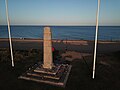 The stone memorial at Slapton Sands, presented by the US Army
 -
 Aerial view of Slapton Sands, showing the car park and Slapton Ley.
 -
![A gold quarter noble coin of Edward III, dating from c. 1363 – c. 1369, found in Slapton in 2015[18]](//upload.wikimedia.org/wikipedia/commons/thumb/4/49/Medieval_Coin%2C_Quarter_Noble_of_Edward_III_%28FindID_716757%29.jpg/120px-Medieval_Coin%2C_Quarter_Noble_of_Edward_III_%28FindID_716757%29.jpg) A gold quarter noble coin of Edward III, dating from c. 1363 – c. 1369, found in Slapton in 2015[18]
A gold quarter noble coin of Edward III, dating from c. 1363 – c. 1369, found in Slapton in 2015[18]


![A gold quarter noble coin of Edward III, dating from c. 1363 – c. 1369, found in Slapton in 2015[18]](https://en.wikipedia.org/wiki/File:Medieval_Coin,_Quarter_Noble_of_Edward_III_(FindID_716757).jpg)
See also
[edit]Notes and references
[edit]- ^ Location of Slapton nudist beach 50°18′08″N 3°37′59″W / 50.302110°N 3.632976°W
- ^ Harris, Helen (2004). A Handbook of Devon Parishes. Tiverton: Halsgrove. p. 163. ISBN 1-84114-314-6.
- ^ "Slapton Parish Headcounts 2001". neighbourhood.statistics.gov.uk. 1 January 2007. Retrieved 15 July 2016.
- ^ "Parish population 2011". Retrieved 6 April 2015.
- ^ "Map of Devon Parishes" (PDF). Devon County Council. Retrieved 27 July 2015.
- ^ "Slapton, Devon Folio: 102r Great Domesday Book Domesday". The National Archives. 1086. Retrieved 15 July 2016.
- ^ "Tower Inn". Archived from the original on 29 June 2007. Retrieved 10 August 2007.
- ^ Historic England. "Tower of Collegiate Chantry of St Mary (1317950)". National Heritage List for England. Retrieved 10 August 2007.
- ^ Historic England. "Church of St James (1164002)". National Heritage List for England. Retrieved 10 August 2007.
- ^ Clarkson, Steve (June 2016). "Start Point Project" (PDF). Retrieved 28 January 2021.
This Start Point project documents the research carried out by the teamon the inshore shipwrecks on the South Devon coast. It covers the area between Start Point and Prawle Point
- ^ Harper, C.G. (2019). The South Devon Coast. Good Press. p. 165. Retrieved 28 January 2021.
- ^ "Slapton Sands Tank - Submerged". www.submerged.co.uk. Retrieved 24 July 2022.
- ^ Easymalc (2 July 2022). "Slapton Sands and Exercise Tiger". Easymalc's Wanderings. Retrieved 24 July 2022.
- ^ "Site Details". www.uswarmemorials.org. Retrieved 24 July 2022.
- ^ a b "Hallsands". South Devon AONB. Retrieved 18 August 2015.
- ^ "Devon, Cornwall and Somerset's coastline lost millions of tonnes of sand after winter storms". Western Morning News. 22 September 2014. Retrieved 15 July 2016.
- ^ "Slapton (Devon) UK climate averages - Met Office". Met Office. Retrieved 4 July 2024.
- ^ "Monthly Temperature Extremes".
- ^ Robinson, A. "Finds record for: PUBLIC-285337". The Portable Antiquities Scheme. Retrieved 27 August 2022.
External links
[edit]| International | |
|---|---|
| National | |
| Other | |