Hubbry Logo
Spot heightSpot heightMain
Open search
Spot height
Community hub
Spot height
logo
8 pages, 0 posts
0 subscribers
Be the first to start a discussion here.
Spot height
Spot height
from Wikipedia
Not found
Revisions and contributorsEdit on WikipediaRead on Wikipedia
from Grokipedia
A spot height, also known as a spot elevation, is a precise point on a or chart where the vertical distance above or below a specified reference datum—most commonly —is explicitly noted, usually indicated by a small dot, , or symbol accompanied by a numerical value. These annotations supplement contour lines by providing exact data at critical locations, such as hill summits, road intersections, grade crossings, depressions, or flat expanses, enabling users to better interpret terrain relief and navigate landscapes. In , spot heights originated as part of systematic practices to capture localized elevations during topographic mapping, with values often derived from ground surveys, bench marks, or photogrammetric methods and rounded to the nearest meter or foot depending on the map's scale and contour interval. They are selectively placed to avoid cluttering the map while highlighting features essential for applications like , , , and operations, and their accuracy is typically tied to the map's overall , such as the North American Vertical Datum of 1988 (NAVD 88) in the United States, which is being replaced by a new gravity-based as part of the National (NSRS) modernization in 2025-2026. Unlike contours, which depict lines of equal elevation, spot heights offer pinpoint precision, making them invaluable for verifying elevations at non-contour points or in areas of subtle . Modern digital mapping tools, including GIS software, automate spot height generation from elevation models like LiDAR-derived digital elevation models (DEMs), enhancing their utility in contemporary geospatial analysis.

Fundamentals

Definition

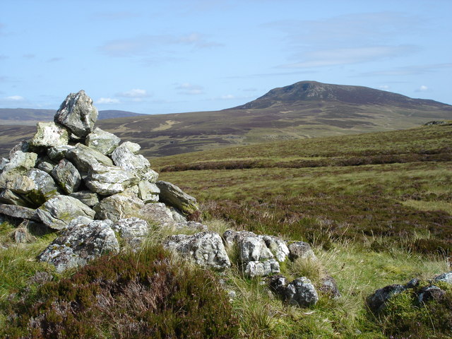
A spot height is an exact point on a map marked with its elevation above a given datum, typically represented as a small dot accompanied by a numerical value in meters or feet beside it. This marking provides a precise vertical measurement for that specific location, often rounded to the nearest meter or foot based on mapping standards. The primary purpose of a spot height is to indicate the of particular geographic features, such as hilltops, saddles, depressions, or changes in , where broader terrain depiction through contour lines may not offer sufficient detail for clarity. These annotations enhance understanding of by pinpointing critical elevations at natural or man-made points of interest, aiding in applications like and land assessment. Examples include natural features like the summit of Knocknacloghoge hill , marked at 532 meters above , or artificial structures such as building roofs where precise height data is relevant for urban mapping. In contrast to general inferred from contour lines—which connect points of equal height to illustrate slopes and landforms—spot heights deliver discrete, explicitly labeled values for targeted precision.

Elevation Datum

A vertical datum provides the reference surface from which elevations are measured positively upward, serving as the baseline for determining heights of terrestrial features such as spot heights. This reference is typically defined relative to mean sea level (MSL), which represents the average height of the ocean's surface over a 19-year tidal cycle, accounting for gravitational and rotational effects on Earth's shape. MSL functions as the global standard for vertical datums in topographic mapping, enabling consistent elevation measurements worldwide. Common vertical datums include region-specific systems designed for precision in national mapping efforts. In the United States, the North American Vertical Datum of 1988 (NAVD 88) is the official standard as of 2025, established through a continent-wide leveling network that adjusts for gravitational variations and supersedes the earlier National Geodetic Vertical Datum of 1929; however, it is scheduled for replacement by a new North American Vertical Reference Frame in 2025-2026. In the United Kingdom, the Ordnance Datum Newlyn (ODN) serves as the primary datum, referenced to the average sea level recorded at a tide gauge in Newlyn, Cornwall, between 1915 and 1921. These datums ensure elevations are tied to locally relevant reference points, facilitating accurate representation of spot heights in official surveys. Variations in vertical datums arise to accommodate regional differences in tidal patterns, gravitational anomalies, and geoid undulations. Local datums may be adopted for specific areas to better reflect these factors, such as tide gauge-based references in coastal zones. Additionally, ellipsoidal heights derived from (GPS) satellites measure distances relative to a smooth mathematical approximating Earth's shape, whereas orthometric heights reference the —the irregular surface of equal gravity potential that closely matches MSL. The difference between ellipsoidal and orthometric heights, known as the geoid height, can vary significantly, often by tens of meters globally. The selection of a directly influences the accuracy and comparability of spot height values, as elevations tied to different datums cannot be directly interchanged without conversion. For example, a location's might differ by 1 to 2 meters when shifting from NAVD 88 to its predecessor NGVD 29 in parts of , with larger discrepancies in regions affected by or tectonic activity. Such variations underscore the need for datum specification in mapping to avoid errors in applications like flood risk assessment or infrastructure planning, where even small differences can have substantial implications.

Cartographic Representation

Symbols and Notation

Spot heights on topographic maps are typically depicted using a small black or brown dot representing the precise location of the measurement, with the numerical value placed adjacent to it. The figure is commonly positioned to the right or northeast of the dot to ensure readability and alignment with map flow. Notation conventions for spot heights generally include the elevation value in either metric or , such as "150 m" for meters or "492 ft" for feet, depending on the mapping standard. These values are rounded to the nearest meter for summits and other significant features to balance precision with cartographic clarity. In some styles, the figures may be rendered in italics or bold for emphasis, particularly on complex terrains, though this is not universally applied. Variations in spot height notation occur based on map scale to manage visual clutter and detail level. On large-scale maps, such as 1:25,000, notations are more precise and frequent, often including values to the nearest meter at key points like road junctions or hilltops. In contrast, smaller-scale maps like 1:250,000 employ selective spot heights with rounded or abbreviated values to highlight major features without overwhelming the layout. Internationally, spot height conventions reflect regional standards, with metric units predominant in —for instance, the in the UK labels heights in meters above mean , such as "1066 m" for notable summits. In the United States, the traditionally uses feet on topographic maps, as in "5280 ft," though some modern publications incorporate metric equivalents during transitions to international alignment. These notations are based on an datum, typically mean , to ensure consistent vertical referencing.

Selection and Placement

Spot heights are selected based on criteria that emphasize representative and informative locations to enhance the understanding of relief without duplicating information provided by contour lines. Priority is given to summits of hills and mountains, cols or saddles between peaks, stable levels at lakes, reservoirs, and riverbanks, and junctions, and points marking significant changes in such as the base or crest of steep inclines. These choices ensure spot heights capture critical data at natural and anthropogenic features that define the landscape's structure. Redundancy with contours is avoided by focusing on discrete points where exact elevations add value, such as hilltops or depressions not fully interpolated from surrounding lines. Placement follows rules designed to associate the elevation value precisely with its feature while preserving map readability. The central dot marking the spot height is aligned with the feature's highest or lowest point, such as a peak summit or valley floor, and the numeric label is offset slightly from the dot to avoid visual overlap with the symbol itself or adjacent map elements like roads or vegetation. Labels are oriented horizontally or vertically adjacent to the dot, prioritizing directions that minimize interference with nearby features and enhance legibility for users. These visual markers, typically a small dot with an adjacent numeral, integrate seamlessly into the map's hypsographic layer. Density guidelines limit spot heights to maintain cartographic clarity, with adjustments for terrain variability—sparser in flat areas and denser in regions of high relief. In digital mapping environments, algorithms automate generation and spacing, using criteria such as minimum separation distances and proximity to key features to optimize distribution and prevent clustering. A primary challenge in selection and placement is balancing comprehensive terrain detail with overall map legibility, especially in rugged or densely featured areas where excessive spot heights can clutter the design and obscure other elements.

Applications

Topographic Mapping

Spot heights play a crucial role in topographic mapping by providing precise absolute values at specific points, which calibrate the relative elevations shown by contour intervals and enable accurate analyses such as calculations for earthwork or assessments for stability. These elevations, typically measured relative to mean , supplement the interpretive nature of contours by offering verifiable data points that ground the map's representation in exact measurements. For instance, in areas with uniform , spot heights ensure that users can interpolate elevations reliably without over-reliance on contour spacing alone. In traditional topographic maps, spot heights are integrated with other cartographic elements like contour lines, hachures for steep slopes, or hill shading to clarify features and resolve visual ambiguities. A spot height at a hill's , for example, confirms the peak marked by converging , preventing misinterpretation of subtle changes. This combination enhances the map's utility for professional applications, where precise understanding is essential. The digital evolution of topographic mapping has transformed spot heights into vector point features derived from digital elevation models (DEMs), as seen in the US Topo series produced by the USGS. These points are automatically generated using tools like those in , which extract elevations from raster data to create layers suitable for geospatial analysis and 3D modeling in GIS environments. In the US Topo format, spot heights are embedded in geospatial PDFs, allowing extraction for advanced visualizations such as terrain simulations. Spot heights contribute to practical benefits in topographic mapping, including support for through detailed data for site suitability assessments and risk evaluation by supplementing elevation models for inundation mapping and identifying high-ground areas. Additionally, they facilitate the creation of elevation profiles for recreational uses like , where key points along trails aid in estimating cumulative gain and effort.

Surveying and Navigation

In , spot heights serve as critical references to validate and refine data. Surveyors measure these elevations on-site using global navigation satellite systems (GNSS) like GPS, which provide heights converted to orthometric heights via models such as OSGM15, achieving accuracies of around 8 mm in controlled conditions. Total stations, combining theodolites for angular measurements with electronic distance measurement, allow precise height calculations through trigonometric leveling from known benchmarks, often used to establish spot heights at key features like hilltops or road intersections during primary surveys. Field techniques for capturing spot heights also include traditional leveling with optical or digital levels for differential height transfers over short distances, ensuring sub-centimeter precision relative to a datum like NAVD 88. Barometric altimeters offer a rapid, portable alternative for preliminary surveys in expansive terrain, estimating height from variations calibrated against known points, though with accuracies typically limited to several meters due to weather influences. These measurements ground-truth data, such as LiDAR-derived elevations, by confirming spot heights at validation sites to update digital elevation models. In , spot heights enable practical assessments in and operations by quantifying . Hikers and GPS-enabled apps, such as those integrating topographic maps, use spot heights to generate profiles, interpolating between marked points to estimate cumulative ascent and descent for routes and gauging physical demands. In contexts, spot heights facilitate line-of-sight analysis by plotting vertical profiles to identify visible ranges for observation or , while differences inform energy expenditure models for troop movements across varied slopes. Despite their utility, spot heights face limitations in remote areas where datum inconsistencies arise, such as deviations up to 1 meter between local geoids like and global models due to sea surface . Vegetation cover, including dense forests or tall grasses, obstructs ground-penetrating measurements in GNSS or surveys, leading to biased elevations that reflect canopy tops rather than bare , with potentially significant errors. To mitigate these, surveyors often supplement with or aerial , though reliance on such indirect sources can propagate uncertainties in datum transformations across rugged terrains.

Contour Lines

Contour lines are imaginary lines connecting points of equal on the Earth's surface, usually referenced to mean . They are spaced at uniform vertical intervals, termed the contour interval—such as 10 in regions of moderate —where the proximity of lines reflects steepness, with closely packed lines signifying steep gradients and widely separated ones indicating flat . These lines are derived from spot heights collected during field surveys, employing techniques to bridge discrete elevation data into continuous representations. In practice, methods like along triangulated networks of spot elevations determine intersection points for each contour level, ensuring smooth progression across the . Contour lines facilitate interpretation of features by illustrating overall configurations; V-shaped patterns pointing upstream denote valleys, while closed loops encircle hills or depressions, with hatchures marking the latter. Their arrangement also supports computations, where is derived from the vertical rise (contour interval) divided by the horizontal run between lines, providing quantitative insights into terrain inclination. In contrast to isolated spot heights, contour lines deliver a comprehensive view of topographic relief, enabling visualization of landscape morphology without the need for numerous labeled points.

Benchmarks and Trig Points

Benchmarks are permanent physical markers used to denote precise elevations above a reference datum, typically embedded in structures, buildings, or . These markers, often caps or disks approximately 3.5 inches in diameter, are inscribed with the exact value, a , and the date of establishment, derived from national geodetic surveys. In the United States, the National Geodetic Survey (NGS) maintains over 1 million such benchmarks as part of the National Spatial Reference System, providing fundamental control points for measurements. These benchmarks ensure consistency in height determinations, with spot heights on topographic maps frequently placed at or near their locations to offer verifiable for mapping accuracy. Trig points, also known as triangulation pillars or trig pillars, are obelisk-like structures erected on prominent hilltops or high points to facilitate angular in networks. Primarily associated with the United Kingdom's , these pillars were constructed between 1936 and 1962, with over 6,500 built to support the precise measurement of distances and across the country. Each trig point typically includes a plate at its base inscribed with a spot height relative to the national datum, serving as a reference for both triangulation and vertical control. On maps, spot heights derived from trig points are plotted to anchor the elevation network, ensuring that surrounding contours and features align with surveyed data. The integration of benchmarks and trig points with spot heights underscores their role as foundational elements in geodetic frameworks, where these markers provide the precise, locatable points from which data propagates across maps. For instance, in the UK, many spot heights coincide directly with trig pillar locations to maintain survey integrity, while in the , NGS benchmarks often form the basis for spot height annotations on USGS topographic maps. This linkage enhances the reliability of spot heights for applications requiring exact references. In contemporary , traditional benchmarks and trig points are increasingly supplemented or replaced by modern alternatives such as GPS-based Continuously Operating Reference Stations (CORS), which offer real-time, high-precision elevation data without physical markers. Networks like the NGS CORS in the provide sub-centimeter accuracy for elevations, reducing reliance on legacy monuments while still supporting spot height validation through virtual reference points. Despite this shift, physical benchmarks and trig points remain vital for historical continuity and field verification in areas with limited GPS coverage.

History and Standards

Historical Development

Spot heights, representing precise measurements at specific points on s, emerged during 19th-century national survey efforts to enhance representation beyond rudimentary . In the United States, early applications appeared in pre-USGS surveys from 1867 to 1879, where barometric readings and yielded thousands of spot elevations, such as those documented by surveyor Ferdinand V. Hayden in . The establishment of the U.S. Geological Survey in 1879 formalized this practice, with the agency's first systematic topographic map in 1884 incorporating spot elevations derived from field measurements using aneroid barometers and tape traverses. Similarly, in the , the integrated spot heights into its six-inch-scale maps starting in the 1840s, relying on leveling networks along key routes to support , with more detailed inclusion on larger-scale editions by the 1880s. Technological advancements drove the evolution of spot height determination from labor-intensive manual methods to more efficient techniques. Late 19th-century plane-table surveys, introduced in the 1860s and standardized by the USGS in 1883, allowed surveyors to plot points and elevations directly in the field using alidades for vertical angles, enabling rapid capture of spot heights at critical locations like summits and water features. By the early 1900s, began supplementing these efforts, particularly after , as stereoscopic aerial photographs facilitated the of elevations; the USGS established a multiplex mapping office in the 1930s to model in three dimensions from such imagery. Post-1980s developments in digital technologies, including geographic information systems (GIS), enabled automated and revision of spot heights on historical maps, transforming manual data into seamless datasets for large-scale analysis. Key milestones underscored the growing role of spot heights in cartographic innovation. In 1894, USGS Director Charles D. Walcott mandated the inclusion of spot elevations at township and section corners on public land maps, followed by 1896 legislation requiring at least two per township west of the 95th meridian to improve land management accuracy. The USGS introduced spot heights alongside shaded relief on maps in 1913, pioneered by topographer John H. Renshawe for western national parks like Yellowstone, where light and dark tints emphasized slopes derived from elevation data. In recent years, deep learning techniques have facilitated the automated extraction and recognition of millions of spot heights from the USGS Historical Topographic Map Collection (HTMC), aiding revisions and digital terrain modeling. This development was significantly influenced by military requirements, particularly during , when accurate terrain analysis for artillery and strategy demanded precise elevation data; British and Allied forces relied on enhanced topographic maps to evaluate Flanders-Somme region landscapes, prompting accelerated national mapping programs.

Mapping Agency Standards

The (USGS) employs spot heights in its US Topo maps, introduced in , as black dots accompanied by numeric elevation values in feet or meters, aligned with the map's contour interval and unit system specified in the margin. These are mandatory at hill and mountain summits, depressions (often marked with a specific symbol and value), and horizontal control points such as survey markers to provide precise vertical references. Bench marks, denoted as "BM" followed by the elevation (e.g., "BM 5280"), indicate third-order or higher surveyed points, typically at section corners or other control locations. In the , the (OS) standardizes spot heights as small point symbols with numeric labels rounded to the nearest meter, using the Newlyn (ODN) as the vertical reference since the adoption of metric units in the . Placement prioritizes critical terrain features, including trig points for pillars, water edges, peaks, depressions, passes, saddles, and major slope changes, to enhance relief interpretation without overwhelming the map. Digital OS Maps integrate these as extractable vector elements, allowing users to query and export spot heights alongside for applications in GIS and navigation. The Institut Géographique National (IGN) in France utilizes a comparable dot notation for spot heights on topographic maps, with elevations expressed in meters relative to the mean sea level (MSL) datum defined by the Nivellement Général de la France (NGF). These are positioned at key elevations such as summits and depressions, integrated into series like the TOP 100 and RGE ALTI models, where metadata specifies the vertical datum for consistency across datasets. Globally, the International Cartographic Association (ICA) advocates for spot height standards that minimize visual clutter through selective placement and generalization, ensuring they complement other relief elements like contours without obscuring essential map features. This approach, outlined in ICA's map generalization guidelines, emphasizes dependency on surrounding symbology to maintain readability across scales. Recent updates in USGS's The National Map transition spot heights to vector-based formats, enabling dynamic queries via tools like the Elevation Point Query Service, which interpolates elevations in feet or meters for any latitude/longitude input from 3D Elevation Program (3DEP) data. The National Map Viewer further supports interactive spot elevation extraction, allowing real-time visualization and download of vector elevation data without static printing limitations.

References

Add your contribution
Related Hubs
User Avatar
No comments yet.