Hubbry Logo
Swarkestone BridgeSwarkestone BridgeMain
Open search
Swarkestone Bridge
Community hub
Swarkestone Bridge
logo
8 pages, 0 posts
0 subscribers
Be the first to start a discussion here.
Swarkestone Bridge
Swarkestone Bridge
from Wikipedia

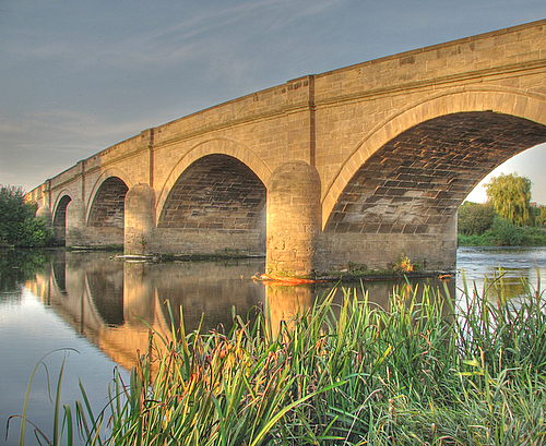
Swarkestone Bridge is a medieval bridge crossing the River Trent between the villages of Swarkestone and Stanton by Bridge, about 6 miles south of Derby. It is currently Grade I Listed and a scheduled monument.

Key Information

History

[edit]
Causeway section

The bridge was built in the 13th century to cross the river and the surrounding marshes. The first mention of the bridge was in 1204 (when it was referred to as Ponte de Cordy), but it has been modified, repaired and rebuilt; the majority of the existing bridge dates, from the late 13th and early 14th century.[1][2] The original bridge is thought to have been made of wood, and was then rebuilt in stone at the end of the 13th century. Three royal grants of tolls for bridge repair were granted between 1324 and 1347.[2]

The bridge and causeway were part of the king's highway between Derby and Coventry. This had been the main route between the two cities since before the Norman Conquest, and there had been a river crossing on the site.[1]

Swarkestone Bridge is, in total, just under a mile long and has 17 arches (six of which have been unaltered since medieval times); it is built primarily of local sandstone.[1] It is the longest stone bridge in England. The section of the bridge crossing the main flow of the river was destroyed in floods in 1795 and was replaced between 1795 and 1797, at a cost of £3,550 (equivalent to £464,400 in 2023),[3] with the present section of bridge.[2] The work was reputedly designed by Thomas Sykes, the county surveyor. However, according to Nikolaus Pevsner, it was designed by Thomas Harrison.[4]

Causeway

The bridge has proved itself of strategic importance throughout the ages. It was for about 300 years the Midlands' main crossing of the Trent, and the only crossing between Burton-on-Trent and Nottingham. The road over the bridge was the main road into Derby from the south until the 18th century. In January 1643, it was the location of the minor battle during the English Civil War. In the Battle of Swarkestone Bridge, the bridge was defended by the Royalists against the Parliamentarians, but the outnumbered Royalists lost the day.[2] In 1745, Swarkestone Bridge was the southernmost point of Bonnie Prince Charlie's advance on London, in his attempt to claim the British throne.[1] Finding no reports of support from the south, they turned back to Derby and then retreated to Scotland and their final defeat at the Battle of Culloden.[2]

During the Second World War, it was defended by gun emplacements and tank traps in case of a German invasion.[1]

Bus crossing the bridge

The bridge today

[edit]

The bridge has been widened several times (the first in 1799 and recorded works in 1808, 1830 and 1852), but is undersized for modern traffic; in several places it is scarcely two lanes and cars are unable to pass at several points.[1]

Though there is a weight limit of 7.5 tonnes, the walls of the bridge often take damage from traffic. In 2017, electronic weight sensors were placed at either end of the bridge to deter vehicles over the 7.5-tonne limit.

Local legends

[edit]

The bridge is the subject of several local legends. Its construction was said to have been financed by the two Bellamont sisters. Both had become engaged and were to throw a joint celebration; their fiancés, however, had to meet with the local barons on the far side of the river. Following a storm the Trent became swollen. Eager to return to their brides-to-be and their party, the men tried to ford the river on horseback. Both were swept away and drowned. The Bellamont sisters commissioned the bridge so that no one else would suffer the tragedy they had suffered. Neither sister married and both died in poverty having exhausted their fortune on building the bridge[5] and are buried in a single grave in Prestwold, Leicestershire,[citation needed]

The bridge is supposed to be haunted by the ghosts of the two Bellamont sisters. Others have alleged the bridge is haunted by Bonnie Prince Charlie's troops. The most commonly reported phenomenon is the sound of horses approaching at speed when there is nothing about. Another legend says that the river must claim three lives every year in order for it to be 'pacified'.[5] The bridge is a local accident black-spot, with 15 reported road-traffic accidents between 2008 and 2010.[6]

See also

[edit]

References

[edit]
Revisions and contributorsEdit on WikipediaRead on Wikipedia
from Grokipedia
Swarkestone Bridge and Causeway is a medieval stone structure in , , that crosses the River Trent and its surrounding floodplains between the villages of Swarkestone and Stanton by Bridge, serving as a vital link on the A514 road south of . Constructed primarily from coursed squared and , it consists of a bridge with five segmental arches and an extensive causeway supported by multiple pointed and segment arches, making it the longest stone bridge in at three-quarters of a mile (approximately 1.2 kilometers) in total length. First documented in 1204 as a likely wooden bridge known as "ponte de Cordy," the structure was rebuilt in stone during the late 13th to early 14th centuries, with tolls granted between 1324 and 1347 to fund maintenance. The , dating to this period, features medieval elements such as a stringcourse and masons' marks, though it has undergone significant repairs and widening in the 18th and 19th centuries, including the addition of buttresses and blue brick arches in 1899. The original bridge was destroyed by floods in 1795 and promptly rebuilt between 1795 and 1797, probably by engineer Thomas Sykes, incorporating cutwaters and strips for added stability. Designated as a Grade I listed building since 1967 and a scheduled , Swarkestone Bridge holds exceptional architectural and historical significance as part of the medieval King's Highway connecting to and as the only Trent crossing between Burton-upon-Trent and for centuries. It played key roles in historical events, including damage during the and marking the southernmost point reached by Bonnie Prince Charlie during his 1745 Jacobite retreat, after which his forces turned back upon learning of approaching royalist armies. Today, it remains an important transport route while preserving its medieval character amid ongoing flood risks from the Trent.

Introduction

Location and Geography

Swarkestone Bridge is situated in , , linking the villages of Swarkestone and Stanton by Bridge in the district. It lies approximately 6 miles (9.7 km) south of , serving as a key crossing point in the region's transport network. The bridge's precise location is at coordinates 52°50′52″N 1°27′8″W, corresponding to the grid reference SK 37027 27808. It forms an integral part of the A514 road, which runs from toward Ticknall and beyond. Geographically, the structure spans the River Trent, the third-longest river in , while extending across the adjacent flood-prone marshes that characterize the Trent Valley. This positioning over low-lying, historically marshy terrain underscores its role in navigating the challenging topography of the area, where the river's broad has long posed obstacles to overland travel. The portion traverses this waterlogged ground, facilitating connectivity between higher grounds on either side.

Overview and Significance

Swarkestone Bridge is a medieval stone bridge and causeway spanning the River Trent and surrounding marshes between the villages of Swarkestone and Stanton by Bridge in , . At nearly one mile (1.2 km or 1,304 yards) in total length, it holds the distinction of being the longest stone bridge in and the longest inland bridge of its kind. Designated as a Grade I listed building since 1967 and a scheduled , the structure is recognized for its exceptional historical and architectural value, preserving elements from its 13th- or 14th-century origins. The bridge's significance stems from its role as the primary crossing point over the River Trent in the for several centuries, serving as a vital for regional trade, travel, and military movements along ancient highways predating the . Although the current structure dates to the medieval period, with the first documented reference in , evidence indicates a river crossing existed on the site well before then, underscoring its longstanding strategic importance. For approximately 300 years, it functioned as the main Trent crossing in the region and the sole bridge between Burton-upon-Trent and , facilitating the transport of goods and people across the flood-prone valley. In terms of regional connectivity, Swarkestone Bridge links key settlements in southern , enabling essential east-west travel through the Trent valley and supporting economic and social exchanges in the area. Its enduring presence highlights the engineering ingenuity required to navigate the river's challenging marshes, contributing to the broader heritage of transport infrastructure in central .

Historical Development

Medieval Origins and Construction

The origins of Swarkestone Bridge trace back to at least the early , when it served as a critical crossing over the River Trent and its surrounding marshes in , forming part of the ancient king's highway linking to . An initial causeway was in existence by 1204, providing a vital route for regional travel and trade across the flood-prone Trent Valley, though archaeological evidence from nearby sites suggests wooden precursors may date to the 11th and early 13th centuries. The bridge received its first documented mention in , recorded in historical as "Ponte de Cordy," at which time it was likely a wooden structure susceptible to the Trent's frequent floods and subject to regular maintenance needs. This early form replaced or supplemented even older fording points or rudimentary crossings, reflecting the strategic importance of the location for connecting northern and amid challenging marshland terrain. By the late , the structure began transitioning to a more durable stone construction, spanning circa 1250 to 1350, to better accommodate growing traffic from merchants and travelers while replacing the vulnerable wooden elements. The primary motivation for this medieval construction was to ensure safe and reliable passage over the expansive Trent marshes, facilitating local trade along key routes and supporting the economic integration of communities with broader networks. While local attributes the initiative to two Bellamont sisters funding the work after personal tragedies, historical points instead to communal and royal interests in enhancing for and connectivity. To fund ongoing repairs and upkeep, royal permissions granted tolls on the bridge in 1324 and 1347, marking early efforts to sustain this essential medieval engineering feat.

Reconstructions and Modifications

In 1795, a severe flood destroyed the section of Swarkestone Bridge that spanned the River Trent, necessitating a complete rebuild of that portion. The reconstruction occurred between 1795 and 1797, at a total cost of £3,550 (approximately £570,000 in 2025 values, adjusted for using the UK Consumer Price Index). This new river-crossing segment featured five arches, replacing the original medieval structure that had succumbed to the floodwaters. The design of the 1795–1797 rebuild is attributed by some sources to Thomas Sykes, who served as Derbyshire County Surveyor at the time. However, architectural historian proposed that it was instead the work of Thomas Harrison, a noted engineer from . To address growing traffic demands in the late 18th and 19th centuries, the bridge underwent several widenings and repairs. These included expansions in 1799 and 1808, during which two arches were rebuilt; further widening of the curved causeway section in 1830; and additional west-side widening in 1852–1854, accompanied by the addition of iron ties for reinforcement. An east-side widening followed in 1853, enhancing the bridge's capacity while preserving much of its medieval form. Among the bridge's lost features are a former and a toll house, both of which were situated partway along the structure to support maintenance and passage fees but have since disappeared. The , served by priests from Priory, represented a common medieval provision for travelers on such crossings.

Key Historical Events

Prior to the construction of the medieval bridge, the site at Swarkestone likely served as a ford or early crossing over the River Trent during the Anglo-Saxon period, facilitating regional travel and potentially playing a role in local conflicts due to its strategic position on a key route. The area's Anglo-Saxon settlement origins, evidenced by archaeological finds on nearby river terraces and the village's "-ton" suffix, suggest human activity dating back centuries before the , with the location possibly defended as early as 874 when land was granted to the Dane Swerkir. During the , Swarkestone Bridge became a defensive chokepoint in a minor skirmish on January 6, 1643, known as the Battle of Swarkestone Bridge. forces under local commander Sir John Harpur barricaded and defended the bridge against Parliamentarian troops led by Sir John Gell, but the outnumbered were defeated after a brief engagement that resulted in eight deaths and several wounded, with only one Parliamentarian injured. The Parliamentarians dismantled the barricades and partially demolished part of the bridge to hinder movements, underscoring the structure's role as a vital crossing for military logistics in the . In the Jacobite Rising of 1745, Swarkestone Bridge marked the southernmost extent of Prince Charles Edward Stuart's (Bonnie Prince Charlie) advance into England, serving as a critical crossing point for his army en route to Derby. On December 4, 1745, Jacobite forces captured and held the bridge, the only Trent crossing between Burton-upon-Trent and Nottingham, allowing the army to push northward to Derby before turning back on December 6 due to lack of English support and approaching government troops. This event highlighted the bridge's enduring strategic importance as a gateway to the Midlands, with a commemorative cairn now marking the site's significance in the failed invasion.

Architecture and Engineering

Design and Structure

Swarkestone Bridge consists of a bridge proper spanning the River Trent, extended southward by a long that crosses the surrounding marshy flood plain, forming a continuous approximately three-quarters of a mile in total length. The layout integrates the river crossing with the , where the arches over the Trent transition into a series of smaller arches elevated above the low-lying to allow floodwaters to pass underneath. The structure features a total of 17 arches, of which six remain unaltered from the medieval period, primarily within the sections. Over the main flow of the Trent, there are five segmental arches, originally constructed in 1795–1797 to replace an earlier medieval crossing damaged by flooding. These river arches are ramped toward the center, supported by cutwaters and triangular buttresses that enhance stability against water currents. The arches vary in form, including medieval segment-pointed and rounded designs, some with double chamfering and masons' marks indicating their late 13th- or early 14th-century origins. Originally narrow at about 9 feet (2.7 meters) wide to accommodate packhorses, the bridge's roadway was widened in stages, reaching up to 19 feet (5.8 meters) in places by the mid-19th century to support carts and later traffic. The total span encompasses the river arches and the extended sections, which function as raised embankments with integrated revetments, including buttresses and strips, designed to mitigate flooding in the marshy Trent Valley terrain. Iron ties added in 1854 further reinforce the structure against lateral pressures from water flow and soil movement.

Materials and Techniques

The primary material used in the construction of Swarkestone Bridge is local , sourced from quarries in , selected for its durability and resistance to the damp conditions of the Trent . This appears in the form of coursed squared blocks for the main structure and finely dressed for the arches and detailing, providing a smooth, uniform finish that enhances load-bearing capacity. Construction techniques employed medieval for the bridge's arches, involving precisely cut and fitted stones to form double-chamfered segmental and pointed designs that distribute weight effectively over the soft, marshy ground. Blocks were hand-quarried and shaped on-site or nearby, bound together with —a mixture of slaked lime, , and water—to allow flexibility and breathability in the structure, accommodating minor movements from flooding without cracking. The associated , integral to the bridge's design, was built using compacted earth embankments reinforced with stone revetments and arched supports to elevate the roadway above the , preventing erosion and ensuring stability across the nearly three-quarter-mile span. These medieval methods, dating to the late 13th or early , relied on masons' marks for and triangular buttresses for added support against lateral forces. In the , widenings and repairs maintained visual harmony by incorporating similar alongside brick reinforcements, such as red and blue engineering bricks for arch strengthening, to blend with the original aesthetic while addressing structural needs.

Cultural Aspects

Local Legends and Folklore

One prominent local legend surrounding Swarkestone Bridge centers on the Bellamont sisters, two noble heiresses who purportedly commissioned its in the 13th century after their fiancés drowned while attempting to cross the treacherous . According to the tale, the sisters, grief-stricken and determined to prevent similar tragedies, financed the bridge using their fortune, ensuring a safe passage for future travelers; they remained unmarried and were buried together in a single grave at Prestwold Church in . This story underscores the bridge's origins as a to lost love and the river's perilous nature, with the sisters' spirits often invoked as protective yet sorrowful guardians of the crossing. Hauntings associated with the bridge frequently feature apparitions of the Bellamont sisters themselves, said to wander the structure on misty nights, their ethereal figures searching eternally for their drowned lovers. Witnesses have reported sightings of these ghostly women in period attire, accompanied by chilling whispers or cries echoing over the water, reinforcing the legend's emotional resonance. Additionally, the bridge is reputed to be haunted by spectral remnants of Bonnie Prince Charlie's Jacobite troops from their 1745 march, including apparitions of soldiers and the distant sounds of marching feet and galloping horses, evoking the chaos of that fleeting .

Associated Sites and Traditions

The Swarkestone Bridge once featured a medieval situated near its center, constructed around the mid-13th century and likely using timber from royal woods in 1249. This structure, served by priests from Repton Priory, functioned primarily to offer masses for the souls of travelers and pilgrims crossing the bridge, reflecting its role as a key river crossing on medieval routes. By 1503, the chapel had fallen into neglect without a resident priest for two decades, and it had completely deteriorated and vanished by the mid-16th century following the in 1538. A toll house formerly occupied a position midway along the bridge, serving as a collection point for pontage fees that supported and repairs. Royal grants authorizing these tolls were issued between 1324 and 1347, with charges varying by goods transported, illustrating the bridge's economic importance in medieval trade across the Trent. Local traditions tied to the bridge include guided heritage walks that trace its historical path along the River Trent and adjacent , often highlighting its medieval construction and strategic past. Annual events, such as the Jacobite re-enactment on the first Saturday in December, commemorate the bridge's role in 1745 when advancing forces under Bonnie Prince Charlie seized it during their march toward , underscoring its military significance in the Jacobite Rising. These walks and gatherings also evoke the bridge's earlier involvement in pilgrimages and Civil War skirmishes, like the 1643 battle that damaged nearby structures, fostering community appreciation for its layered history. Nearby, the ruins of Swarkestone Hall, an Elizabethan manor built by Sir Richard Harpur before 1577, represent a prominent associated site, with surviving 17th-century gate piers and a banqueting pavilion that once overlooked the Trent. The hall, damaged during the English Civil War, was demolished in the mid-18th century but remains linked to the area's gentry heritage. Adjacent Swarkestone Lock, completed in 1777 as part of the Trent and Mersey Canal, enhanced the Trent navigation system established by the 1699 Act, facilitating improved river transport for industrial goods in the post-medieval era.

Preservation and Modern Use

Current Condition

Swarkestone Bridge remains in a stable structural condition overall, though it is vulnerable to periodic flooding from the , which affects the surrounding low-lying areas and has prompted regular flood warnings for the site. The bridge undergoes ongoing minor repairs to address wear and damage caused by traffic on the A514 road, including incidents where vehicles have collided with its parapets. The bridge's narrow width, measuring approximately 12 feet between parapets, makes it undersized for modern vehicles, leading to frequent scrapes and collisions with the stone walls as larger trucks navigate the tight confines. A weight limit of 7.5 tonnes is enforced to protect the Grade I listed structure, yet around 40 heavy goods vehicles exceed this daily, contributing to accelerated deterioration despite a 40 mph speed restriction. To mitigate these issues, electronic weight sensors were installed at either end of the bridge, integrated with vehicle-activated signs that alert and deter overweight loads approaching the crossing. Despite these challenges, the bridge continues to serve local vehicular traffic while accommodating pedestrians and cyclists, and it remains a popular spot for scenic walks along the River Trent.

Conservation and Access

Swarkestone Bridge is protected as a Grade I listed building under the Planning (Listed Buildings and Conservation Areas) Act 1990 and as a scheduled under the Ancient Monuments and Archaeological Areas Act 1979, both managed by . Derbyshire County Council provides additional oversight through its responsibility for highway maintenance and enforcement of traffic regulations on the structure. Preservation efforts include regular structural inspections and monitoring conducted by to enforce the 7.5-tonne weight restriction and 40 mph , aimed at mitigating damage from heavy vehicles. Heritage funding has been pursued for broader improvements, such as a proposed bypass, though securing resources remains a challenge; a 2010 assessed options for diverting traffic to reduce wear on the medieval stonework, but proposals have not progressed significantly and remain stalled as of 2023. defenses in the surrounding Trent Valley contribute indirectly to the site's protection, with local authorities coordinating maintenance to address historical vulnerability to inundation. Public access to the bridge is permitted around the clock as part of the public , with pedestrian pathways along the encouraged for visitors to appreciate its historical features. Restrictions prohibit vehicles over 7.5 tonnes, enforced through signage and occasional fines to preserve the structure, while lighter traffic and cyclists are accommodated. Guided tours are occasionally available during local heritage events, such as walking festivals in , highlighting the bridge's role in regional history. Ongoing challenges include frequent violations of weight limits by heavy goods vehicles, leading to repeated enforcement actions and proposals for traffic diversion schemes to alleviate structural stress. Efforts to update preservation techniques focus on integrating modern engineering assessments with traditional conservation methods, though funding constraints have delayed comprehensive upgrades.

References

Add your contribution
Related Hubs
User Avatar
No comments yet.