

Community hub
Recent from talks
Contribute something
Nothing was collected or created yet.
Syncline
View on Wikipedia
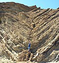
In structural geology, a syncline is a fold with younger layers closer to the center of the structure, whereas an anticline is the inverse of a syncline. A synclinorium (plural synclinoriums or synclinoria) is a large syncline with superimposed smaller folds.[1] Synclines are typically a downward fold (synform), termed a synformal syncline (i.e. a trough), but synclines that point upwards can be found when strata have been overturned and folded (an antiformal syncline).
Characteristics
[edit]On a geologic map, synclines are recognized as a sequence of rock layers, with the youngest at the fold's center or hinge and with a reverse sequence of the same rock layers on the opposite side of the hinge. If the fold pattern is circular or elongate, the structure is a basin. Folds typically form during crustal deformation as the result of compression that accompanies orogenic mountain building.
Notable examples
[edit]- Powder River Basin, Wyoming, US
- Sideling Hill roadcut along Interstate 68 in western Maryland, US, where the Rockwell Formation and overlying Purslane Sandstone are exposed
- Forêt de Saou syncline in Saou, France
- Southland Syncline in the southeastern corner of the South Island of New Zealand, including The Catlins and the Hokonui Hills
- Strathmore Syncline, Scotland
- Wilpena Pound, Flinders Ranges, South Australia
- Fort Valley, Shenandoah County, Virginia
- Hondo Syncline in the Picuris Mountains of New Mexico, an example of an overturned syncline[2]
- Afikpo syncline, Nigeria
Gallery
[edit]-
 Syncline exposed in Sideling Hill roadcut
 -
 Snow-dusted syncline in Provo Canyon, Utah
 -
 Road cut near Fort Davis, Texas showing a syncline
 -

-
 Syncline in the lower parking lot of Calico Ghost Town; the ductile folding is at the base and the brittle is above.
 -
 Synclinal fold in Silurian Wills Creek Formation or Bloomsburg Formation at Roundtop Hill (Maryland)
 -
 East wall of Bear Valley Strip Mine, near Shamokin, Pennsylvania
 -

-
 Satellite view of part of New Zealand's Southland Syncline, showing parallel folds running northwest–southeast
 -
 Wilpena Pound, a synclinal basin in the Flinders Ranges of South Australia


See also
[edit]References
[edit]- ^ Synclinorium. (2008). In Encyclopædia Britannica. Retrieved May 03, 2008, from Encyclopædia Britannica Online: http://www.britannica.com/EBchecked/topic/578375/synclinorium
- ^ Bauer, Paul W.; Williams, Michael L. (August 1989). "Stratigraphic nomenclature ol proterozoic rocks, northern New Mexico-revisions, redefinitions, and formalization" (PDF). New Mexico Geology. 11 (3): 45–52. doi:10.58799/NMG-v11n3.45. Retrieved 15 April 2020.
This article about structural geology is a stub. You can help Wikipedia by expanding it. |
Syncline
View on GrokipediaFundamentals
Definition
A syncline is a fold in stratified rock layers that arches downward, forming a concave-upward, trough-like structure in which the strata dip inward toward a central axis from both sides.[5] This configuration results from compressional forces deforming the rock, creating a symmetric or asymmetric basin-shaped feature observable in sedimentary sequences.[6] The primary structural elements of a syncline include the hinge line, which traces the axis of maximum curvature where the fold bends sharply; the limbs, representing the two sloping sides that extend outward from the hinge; and the axial plane, an imaginary surface that bisects the fold perpendicular to the hinge line, dividing it into mirror-image halves in symmetric cases.[7] In typical synclines, the youngest rock strata occupy the core along the axis, while progressively older layers appear on the outer portions of the limbs due to the preservation of depositional sequences during folding.[8] The term "syncline" derives from the Greek roots "syn-" (together) and "klinein" (to incline or lean), reflecting the inward convergence of the layers, and entered geological usage in the mid-19th century amid studies of folded sedimentary terrains.[9] As the inverse of an anticline, a syncline contrasts by having strata that converge downward rather than arching upward.[10]Key Characteristics
Synclines exhibit a distinctive trough-shaped profile in cross-section, characterized by a concave-upward curvature where rock layers dip inward toward the central axis.[11] This morphology results in a U-shaped or V-shaped structure, depending on the tightness of the fold, and synclines may display symmetrical or asymmetrical forms, with one limb potentially steeper than the other.[12] In symmetrical synclines, both limbs dip at comparable angles toward the axis, while asymmetrical variants feature unequal dips, often influenced by the orientation of the axial plane.[13] The scale of synclines varies widely, ranging from small structures on the order of meters in wavelength and amplitude to large basin-like features spanning kilometers.[11] Wavelength, measured as the distance between adjacent fold axes, and amplitude, representing the vertical distance from the axis to the inflection points on the limbs, provide quantitative indicators of fold size; for instance, microscopic crinkles measure mere centimeters, whereas regional synclines can extend tens of kilometers across.[8] These dimensions influence the overall geometry observed in the field, with larger synclines forming prominent topographic depressions.[14] Stratigraphically, synclines are marked by a sequence where younger rock layers occupy the core, and progressively older layers appear on the outward-dipping limbs, creating a normal age progression from the axis outward.[12] In tight synclines, this can lead to overturned limbs, where strata on one or both sides are inverted, resulting in an apparent reversal of the stratigraphic sequence along those segments.[15] Associated features include the development of axial traces on geologic maps, which represent the surface intersection of the fold's axial plane and serve as a key identifier for syncline locations.[16] In eroded landscapes, synclines often manifest as valleys or lowlands where younger core rocks are exposed at the surface, flanked by older strata on elevated limbs, creating characteristic exposure patterns that aid in structural interpretation.[14]Formation and Processes
Mechanisms of Folding
Synclines primarily form through ductile deformation of layered sedimentary or metamorphic rocks subjected to compressional stress, which induces buckling and creates concave-upward folds in the rock strata.[17] This process occurs predominantly at depth where elevated temperatures and confining pressures promote plastic behavior rather than brittle failure, allowing rocks to bend without fracturing.[11] Compressional tectonic forces drive this deformation by shortening the crust horizontally, leading to vertical thickening and fold development.[11] The development of synclines progresses through distinct stages of deformation. Initially, rocks undergo elastic bending, where layers shorten parallel to themselves up to about 20% strain before instability sets in and buckling initiates.[17] As strain increases, deeper layers transition to plastic flow, amplifying the folds through limb rotation and structural softening, which allows for continued ductile accommodation.[17] In the brittle upper crust, late-stage fracturing may occur, potentially locking up the folds into tighter configurations or introducing minor faults.[17] Several factors influence the mechanics and final form of synclinal folding. Rock competency plays a critical role, with stiffer (more competent) layers, such as sandstones, buckling more readily than surrounding softer (incompetent) layers like shales when viscosity contrasts exceed 10:1.[17] Higher temperatures and pressures enhance ductility, favoring flow folding in deeper crustal levels, while slower strain rates permit greater amplification and longer dominant wavelengths in the folds.[17] Basic fold geometry quantifies syncline tightness, particularly in symmetrical cases. For a symmetrical syncline with a vertical axial plane, the interlimb angle relates to the limb dip angle (measured from horizontal) as , where tighter folds exhibit smaller values approaching 0° in isoclinal stages.[18] This relation highlights how progressive deformation steepens limb dips, reducing the interlimb angle and increasing fold closure.[18]Tectonic Influences
Synclines primarily form in tectonic settings characterized by convergent plate boundaries, where the collision or subduction of lithospheric plates induces crustal shortening that deforms sedimentary layers into downward-arching folds.[19] During subduction, the denser oceanic plate descends beneath a continental plate, generating compressional forces that propagate inland and buckle overlying strata into synclinal structures as part of broader fold-thrust belts. Compressional stress serves as the key initiating force in these environments, leading to the systematic development of alternating anticlines and synclines. These structures are closely associated with major orogenic events, such as the Alpine orogeny, where continental collision between the African and Eurasian plates during the Cenozoic era produced extensive fold systems through prolonged shortening and thickening of the crust.[20] In such mountain-building episodes, synclines emerge as integral components of the deformational fabric, accommodating strain via ductile folding in the upper crust while deeper levels experience metamorphism and thrusting.[21] Secondary influences on syncline formation arise from intraplate stresses, often driven by mantle convection or gravitational loading within sedimentary basins far from active plate margins.[22] These far-field stresses can reactivate pre-existing weaknesses, inducing localized folding even in stable continental interiors, as seen in responses to distant subduction dynamics.[23] The formation of synclines typically unfolds over millions of years, aligning with the duration of orogenic cycles that involve episodic pulses of deformation, followed by potential reactivation during subsequent tectonic phases.[24] This prolonged timescale allows for progressive strain accumulation, with initial folding often occurring in the range of 10 to 50 million years, enabling synclines to record multiple phases of tectonic evolution.[25]Variations and Classification
Types of Synclines
Synclines are classified primarily by their geometry and orientation, which reflect variations in the dip of their limbs relative to the axial plane and the configuration of the hinge line, distinguishing their structural diversity.[26] Symmetrical synclines feature limbs that dip toward the hinge at approximately equal angles on either side of the axial plane, resulting in an ideal trough-like shape.[27][26] This configuration often arises in settings of uniform compression, where the fold maintains bilateral symmetry.[14] In contrast, asymmetrical synclines exhibit limbs that dip toward the hinge at unequal angles, with one limb typically steeper than the other, leading to a lopsided profile.[27][26] Such synclines may display S- or Z-shaped asymmetry depending on the rotational sense, often influenced by pre-existing structural weaknesses in the rock layers.[14] Synclines are also classified by tightness, determined by the interlimb angle between the two limbs:- Open synclines have interlimb angles greater than 120°.
- Closed synclines have angles between 120° and 60°.
- Tight synclines have angles less than 60°.
- Isoclinal synclines have nearly parallel limbs with angles approaching 0° to 10°.[26][27]
Structural Features
The hinge of a syncline represents the line of maximum curvature along the fold axis, where the rock layers achieve their tightest downward bend, often characterized by a radius of curvature that varies from the hinge to the inflection points on the limbs.[18] The axial plane, an imaginary surface bisecting the fold through the hinge line across successive layers, typically divides the syncline symmetrically in non-inclined examples, though it may curve in complex structures.[18] Plunge angles measure the tilt of the hinge line from the horizontal, with horizontal hinges at 0° indicating non-plunging synclines, while plunging varieties exhibit angles up to 90°, influencing the overall three-dimensional geometry.[18] Syncline limbs consist of the sloping rock panels extending from the hinge, with dip amounts typically ranging from gentle (less than 30°) to steep (over 60°) toward the fold trough, depending on the degree of tightness.[18] Thickness variations along the limbs often result from differential compaction in sedimentary layers or strain during folding, leading to thinner profiles on extended limbs compared to the hinge zone in similar fold types.[29] For instance, in class 1C folds, hinges may appear thicker relative to limbs due to these effects.[18] Associated minor structures within synclines include parasitic folds, which are smaller-scale folds developed on the limbs or hinge, often displaying S- or Z-shaped asymmetry aligned with the main fold axis.[18] Cleavage development, such as axial plane cleavage, commonly emerges in tighter synclines, particularly in finer-grained rocks, providing a fabric perpendicular to the maximum shortening direction.[18] Faulting may occur along the limbs, especially in asymmetrical or overturned synclines, where shear stresses concentrate and produce minor thrust or normal faults.[18] Mapping syncline structural features relies on stereonets to determine fold axis orientation by plotting poles to bedding planes, allowing calculation of the hinge plunge and axial plane attitude through techniques like the beta diagram or Hansen's method.[30] Cross-section profiling, constructed perpendicular to the fold axis, visualizes limb dips, hinge curvature, and thickness changes, enabling quantitative assessment of fold amplitude and wavelength for accurate three-dimensional reconstruction.[18]Geological Significance
Role in Stratigraphy
Synclines play a crucial role in stratigraphic analysis by exhibiting age inversion, where the youngest rocks occupy the core of the fold, contrasting with the progressively older strata on the outward-dipping limbs. This configuration arises from post-depositional folding, allowing geologists to distinguish synclinal structures from depositional basins and confirm that deformation occurred after sediment accumulation.[5] The preservation of this inverted age sequence facilitates correlation of strata across the fold limbs, enabling reconstruction of original depositional geometries and identification of tectonic disruptions in regional stratigraphic frameworks.[31] In basin evolution studies, synclines serve as key repositories for sedimentary records that document phases of subsidence and deposition, often capturing continuous sequences in subsiding troughs formed during tectonic compression or extension. These structures protect thick accumulations of sediments from erosion, providing insights into the timing and rate of basin filling, such as the transition from marine to terrestrial environments in foreland settings.[15] For instance, growth strata within synclines record progressive subsidence, revealing how tectonic forces influenced sediment supply and accommodation space over geologic time.[32] Synclines contribute to paleoenvironmental reconstruction by preserving diverse sedimentary facies that reflect ancient depositional settings, from marine shelves to fluvial systems, shielded within the fold's core and limbs. Analysis of these facies, such as coal-bearing sequences in synclinal basins, indicates shifts in sea level, climate, and sediment sources, offering evidence for past environmental conditions like humid swamps or shallow seas.[33] This preservation is particularly valuable in tectonically active regions, where synclines maintain intact records of facies transitions that would otherwise be eroded. To refine interpretations of geological history, synclinal stratigraphy is integrated with biostratigraphic data from fossils and geochronologic methods like isotopic dating to precisely time deformation events. Fossils within synclinal sequences help bracket the age of folding by identifying pre- and post-deformational faunas, while radiometric isotopes, such as 40Ar/39Ar in fault gouges, provide absolute ages for tectonic activity.[35] This combined approach enhances correlation across deformed terrains and elucidates the sequence of subsidence, deposition, and uplift in basin histories.[36]Applications in Resource Exploration
Synclines play a significant role in hydrocarbon exploration as structural traps within sedimentary basins, where the downward-folded geometry allows porous reservoir rocks in the synclinal core to accumulate oil and gas beneath impermeable overlying seals, particularly in faulted or tilted configurations that prevent migration.[37] In such settings, the synclinal structure facilitates the pooling of hydrocarbons generated from organic-rich source rocks in adjacent areas, with examples including the Pechora Syncline where Permian-Triassic sequences host potential reservoirs sealed by evaporitic layers.[38] This trapping mechanism is enhanced by stratigraphic layering that positions permeable sandstones or carbonates in the trough while shales or salts form the cap rock, enabling economic extraction through targeted drilling.[39] In mineral resource exploration, synclines are associated with deposits of coal, evaporites, and metallic ores within folded sedimentary sequences, as the trough-like structure preserves and concentrates these materials during deformation. Coal seams often accumulate in synclinal basins due to the subsidence and burial of peat-forming environments, as seen in Carboniferous sequences where folding concentrates thick, minable layers.[40] Evaporites such as gypsum and halite form extensive beds in synclinal evaporative basins, serving both as resources and seals for underlying ores.[41] Metallic ores, including lead-zinc and copper, are linked to synclinal-hosted evaporite systems where brines interact with reduced sediments to precipitate sulfides, exemplified by sediment-hosted deposits in Paleozoic fold belts.[42] Synclines also support groundwater and geothermal resource accumulation, with aquifers forming in the permeable troughs where permeability contrasts trap water in fractured or porous sedimentary layers. In synclinal basins, groundwater flows preferentially along the axis due to lower hydraulic heads, creating confined aquifers suitable for extraction, as observed in the Portland Basin where deep sandstones hold potable water resources.[43] For geothermal applications, hot fluids circulate and pool in synclinal structures, driven by convective flow in low-permeability sediments overlying hotter basement rocks, with thermal springs emerging along the folds; the Krško Basin in Slovenia demonstrates this, where Tertiary infill reaches temperatures viable for direct-use heating.[44] Such accumulations benefit from the syncline's geometry, which enhances heat retention and fluid retention compared to adjacent uplifts.[45] Exploration of synclinal resources relies heavily on seismic profiling to map subsurface geometry and identify drilling targets, as reflection seismic data reveal the fold's depth, width, and associated faults critical for trap integrity. High-resolution 2D and 3D seismic surveys delineate the synclinal axis and reservoir thickness, allowing geophysicists to model migration paths and seal effectiveness for hydrocarbons or minerals.[46] In mineral contexts, seismic methods image ore-hosting layers within the fold, while for groundwater and geothermal, they trace aquifer boundaries and fluid pathways, reducing exploration risks by integrating with borehole data.[47] This approach has proven effective in delineating prospects without extensive initial drilling, prioritizing areas of optimal structural closure.[48]Examples and Case Studies
Prominent Synclines
The Paris Basin Syncline in France represents one of the largest intracratonic synclinal structures in Europe, characterized by a broad, oval-shaped depression with a diameter of approximately 600 km.[49] This Mesozoic feature formed primarily through subsidence from the Triassic to Late Jurassic periods, resulting in thick sequences of sedimentary rocks up to 3 km deep in its central areas, with exposures visible in quarries and outcrops around Paris.[50] In the United States, the Michigan Basin exemplifies a nearly circular syncline covering an area of about 198,000 square kilometers, centered in the Lower Peninsula of Michigan.[51] Filled with Paleozoic sediments ranging from Cambrian to Permian in age, reaching thicknesses of up to 4,300 meters at the basin's center, it features gentle dips averaging 8-18 meters per kilometer and is renowned for its natural gas reserves, particularly from Devonian shales.[52] Surface exposures of these strata occur along the basin's margins in the surrounding states. The Appalachian Synclinorium, stretching across eastern North America from Alabama to New York, forms an elongated trough over 3,200 km in length within the broader Appalachian orogen. Developed during the Late Paleozoic Alleghenian orogeny approximately 325 to 260 million years ago, this structure contains folded Paleozoic sedimentary rocks up to several kilometers thick, with prominent exposures in the Valley and Ridge province where erosion has revealed its layered architecture.[53]Regional Formations
In fold-and-thrust belts, synclines commonly form as complementary structures to anticlinal uplifts during compressional deformation, particularly in regions like the Rocky Mountains where the Laramide orogeny (late Cretaceous to early Tertiary) produced basement-involved thrust systems. These synclines, such as the Bighorn Basin syncline, are bordered by fault-bounded uplifts like the Beartooth and Bighorn Mountains, accommodating thick synorogenic sediments through asymmetric folding propagated by thrust loading.[54][55] Foreland basins adjacent to orogenic belts often host synclinal depocenters that accumulate substantial sedimentary fill, as seen in the Persian Gulf region, part of the Zagros foreland basin system. Here, synclinal structures within the Persian Gulf Synclinorium preserve Cretaceous to Tertiary strata, with depocenters reaching thicknesses exceeding 10 km due to flexural subsidence during Arabian-Eurasian convergence, facilitating hydrocarbon migration and trapping.[56][57] In ancient cratons, Proterozoic synclines can be reactivated during later tectonic events, exemplified by structures in the Canadian Shield's western Churchill Province. These synclinal keels, formed during Paleoproterozoic orogenies around 1.85–1.75 Ga, exhibit reactivation through subsequent deformation, preserving metasedimentary sequences amid stable cratonic interiors while influencing Phanerozoic basin development.[58][59] Regionally, synclines interconnect to form extensive fold trains, where parallel or en echelon alignments of synclinal and anticlinal axes create linear belts spanning hundreds of kilometers, as in convergent tectonic settings. This interconnection arises from uniform layer-parallel shortening, resulting in periodic fold sets that define orogenic domains and control sedimentary routing over broad scales.[60][61]References
- https://www.[researchgate](/page/ResearchGate).net/publication/248837586_Kinematic-stratigraphic_evolution_of_a_growth_syncline_and_its_implications_for_tectonic_development_of_the_proximal_foreland_basin_southeastern_Ebro_basin_Catalunya_Spain
- https://wiki.seg.org/wiki/Michigan_basin